
Belleayre Mountain
Belleayre Mt: Ski Area from Lost Clove
| Quick Look | |||||
|---|---|---|---|---|---|
| Difficulty | Round trip | Total climb | Location | Internet Maps | |
| 6.8 mi. | 2262 ft. | N42 03.70 W74 30.62 | AllTrails | ||
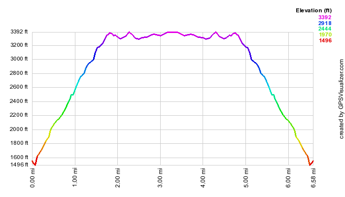
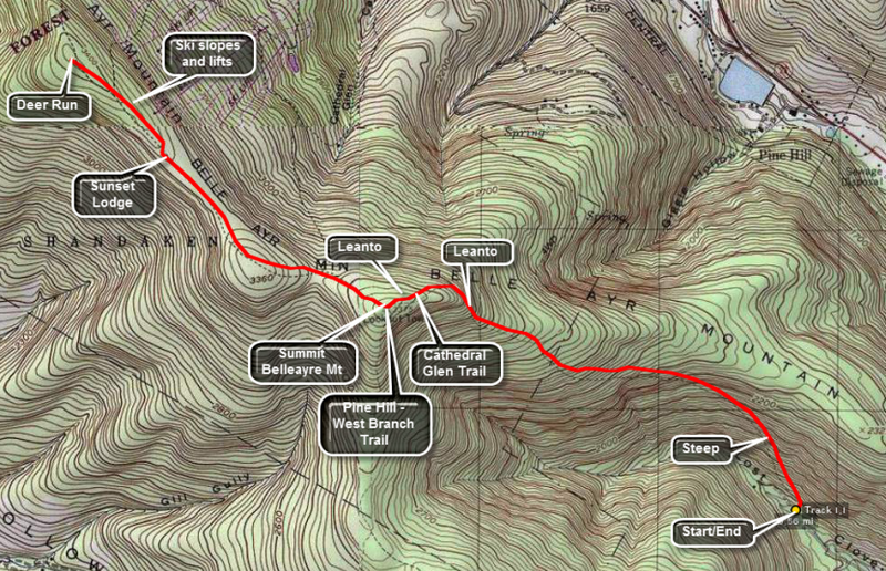 Get on Route 47, the road that runs from Big Indian on Route 28 to Claryville. Turn onto Lost Clove Road just outside the village of Big Indian. Continue for 1.5 miles on Lost Clove Road until the designated parking area on the right. The road dead ends just after this. Walk straight ahead from the parking area onto the red blazed trail. This trail is an easement on private land so stay on the trail at all times. The trail climbs 1300 feet in the next 1.3 miles! It is very steep at times and just steep at others. The trail does follow an old woods road for most of its length which makes the going easier. Some areas have loose stone which makes the footing tricky.
After 1.3 miles the trail enters the forest preserve and shortly after that ends at the blue blazed Pine Hill West Branch Trail. Turn left on this trail. The walking gets easier and a lean-to will be on the right after only .3 miles. Continue passed the lean-to for about .5 miles to the summit of Belleayre Mountain. At this point the Pine Hill West Branch trail turns south toward Balsam Mountain. Walk over the summit, through the field and slightly to your right, and pick up the red blazed Belleayre Ridge Trail. After about .3 miles, there is another lean-to on the right. Just before the lean-to the Cathedral Glen Trail turns to the right. This trail leads down through the ski slopes to the railroad tracks in Pine Hill.
Continue straight ahead on the Belleayre Ridge Trail. The signs for the various ski slopes will start to appear and then ahead will be the lifts and Sunset Lodge. You can continue straight ahead and walk all the way out to Deer Run, the last lift and ski slope on the ridge. Along the way enjoy the view down the slopes into the valley and across to the opposite hills. Be sure to walk around to the "front" of the lodge which offers a nice view of Balsam Mountain. return be retracing the path you used to ascend the mountain.
| Quick Look | |||||
|---|---|---|---|---|---|
| Difficulty | Round trip | Total climb | Location | Internet Maps | |
| 8.0 mi. | 2110 ft. | N 42.13 W 74.49 | AllTrails | ||
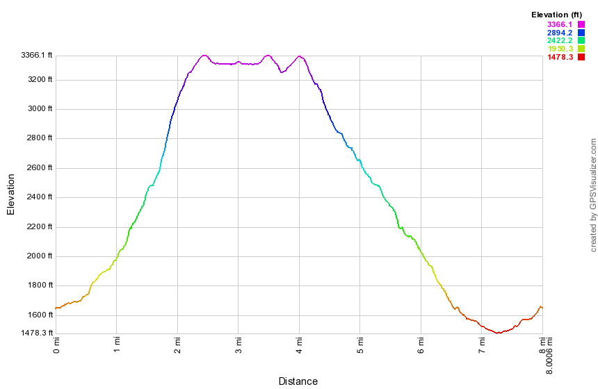
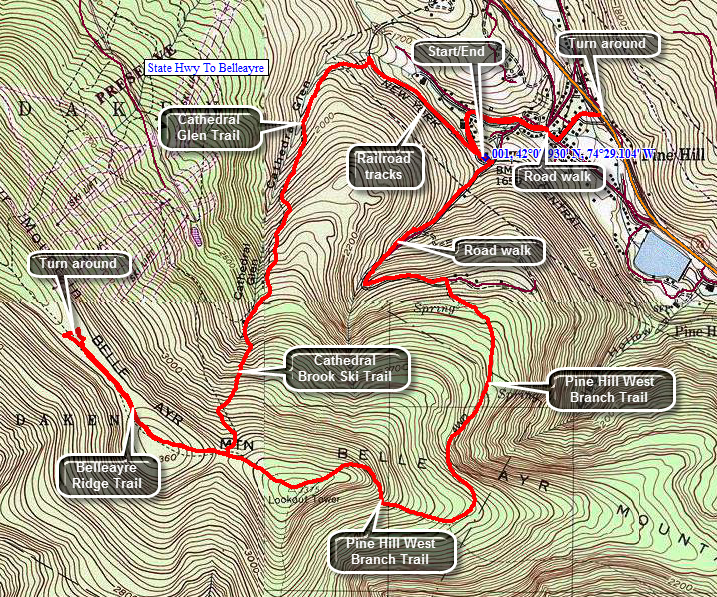 Turn south from Route 28 in Pine Hill onto Elm Street. Turn right at the end of Elm onto Main Street then turn left on Bonnie View Ave. Pass by Old Turnpike Road on the right and Mill Street on the left. Turn left on Station Road, drive to the top of the hill and park on the left side of the road next to the railroad tracks.
Walk west on Station Road and head left into some weeds where the road starts down the hill to the right. After a few feet, you will be on the railroad tracks which are quite interesting. The tracks are complete with ties underneath and stretch for some distance ahead. The rails were bolted together by three massive bolts and nuts and nailed to the tracks with large spikes. After half a mile the blue markers along the tracks stop and a sign clearly shows that the trail turns sharply into the woods on the left. Follow the blue markers into the woods. For the next 1.1 miles the trail climbs 770 feet heading mostly NNE and up toward the ridge. Most of the trail in this area is marked and obvious. The first part of the trail passes through large evergreen trees and parallels Cathedral Brook. At around 1.7 miles the trail meets the Cathedral Brook Ski Trail from Belleayre. Walk across a flat clearing and then started up the ski slope. You should be able to make out a faint hiking trail that meanders up the slope. There were some blazes on the trees on the left side of the slope. The climb is very steep in places and just steep in others. At about 2.1 miles the trail cuts to the left into the woods and the turn is well marked. The trail to the ridge is only about a quarter mile but is not a pleasant experience. This trail section is poorly marked and appears little used. The trail has many rolling rocks that threaten to cause havoc at any moment. Soon you will reach the Belleayre Ridge Trail at about 2.4 miles. Turn right on the Belleayre Ridge Trail and hike out toward the lodge and the first chair lift. On the way you will pass one of the two lean-tos on the ridge. The signs for the various ski slopes will start to appear and then ahead will be the lifts and Sunset Lodge. You can continue straight ahead and walk all the way out to Deer Run, the last lift and ski slope on the ridge. Along the way enjoy the view down the slopes into the valley and across to the opposite hills. Be sure to walk around to the "front" of the lodge which offers a nice view of Balsam Mountain. Walk back to the ridge trail and start back toward the trail junction. At the junction with the Cathedral Glen Trail continue on the Ridge Trail until it meets the blue Pine Hill West Branch Trail on the eastern summit of Belleayre which is marked with a USGS marker. Continue your hike by heading west on the Pine Hill West Branch Trail and dropping over 500 feet in the next .65 miles. The trail is well-maintained and about halfway down you will pass the other lean-to. At about 4.65 miles you will be at the junction with the Lost Clove Trail. Stay to the left on the Pine Hill West Branch Trail. At the next trail to the right continue straight ahead and pick up blue markers in a short distance. The trail begins to get wider and looks a lot like a road passable by a four wheel drive vehicle. At 5.6 miles the trail meets Woodchuck Hollow Road. A sign clearly shows a turn to the left to descend on the road. The road continues to descend and at one point makes a hairpin turn. The land to the left of the road has many stonewalls and a stream paralleling the road. A stonewall that seems to be a retaining wall runs along the stream. Watch for an old wrought iron gate on the right side of the road with a driveway that heads up the hill. The road eventually ends at Station Road near your car. The Pine Hill West Branch Trail actually starts at Route 28 and Elm Street.You can decide whether you want to hike the 1.4 miles out and back through Pine Hill!
| Quick Look | |||||
|---|---|---|---|---|---|
| Difficulty | Round trip | Total climb | Location | Internet Maps | |
| 6.9 mi. | 1880 ft. | N 42.10 W 74.52 | AllTrails | ||
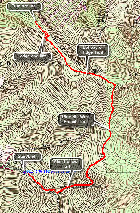 The easiest way to get to the trailhead is to turn south from Route 28 on Dry Brook Road in Arkville. Drive about 4.6 miles and turn right on ToIn about half a mile the road forks and you should bear to the right on Rider Hollow Road. Drive 2 miles to the dead end trailhead.
For the first .35 miles you will be on the red Oliverea-Mapledale Trail that runs along a brook. The brook was almost dry but rose high enough during some of the floods to wash out the footbridge and reroute the stream bed. The bridge has been replaced and the trail rerouted up a hill and away from the stream. At about .35 miles, take the yellow Mine Hollow Trail to the left toward the col between Balsam and Belleayre. The red Oliverea-Mapledale Trail continues up to the col between Balsam and Eagle. The Mine Hollow Trail ascends about 750 feet from the trail junction and stretches .86 miles. The gradient averages only about 17% but this includes some flatter spots with a few short but interesting steeper areas. Along the way there are a few large rocks to walk around but the hike is otherwise a nice walk through the woods. At the junction with the blue Pine Hill-West Branch Trail turn left toward Belleayre. For a short distance this trail is flat but then it begins to ascend to gain the 500 feet more needed to get to the high point on Belleayre. The next junction is with the Belleayre Ridge Trail at the east peak of Belleayre. Checked out the USGS benchmark before following the trail out to the ski area. The walk along the woods road to the ski lodge is about a mile. At this point you will start to see he signs for the various ski trails and chair lift #1. This spot also has a first aid shack and Sunset Lodge. The lodge is a nice place to stop to eat and has a view from the south where the views from the slopes are to the north. You may hike out all the way to the farthest ski trail, Deer Run or interrupt your hike to turn around at any time. Walk back to the Belleayre high point along the ridge trail and make the turn onto the Pine Hill-West Branch Trail. The hike is literally all downhill from this point except for a few nearly flat parts. At the next junction turn right on the Mine Hollow Trail and continue your trip back down to the car.
