North Dome
North Dome is often done in conjunction with Mount Sherrill. Several different approaches are possible and none are easy. Getting down from Sherrill to the north involves avoiding some treacherous cliffs that come upon you suddenly. Beware of the nettles!
| Trailhead Coordinates | |
|---|---|
| Name | Coordinates |
| Spruceton Road (Mink Hollow) | N 42.1919 W74.3248 |
| Route 42 (Shaft Road) | N42.1659 W74.4088 |
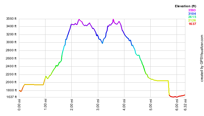
| Quick Look - North Dome and Sherrill from Mink Hollow | ||||
|---|---|---|---|---|
| Difficulty | Round trip | Total climb | Location | Internet Maps |
| 6.3 mi. (7.3 mi.) | 2485 ft. | N42.1733 W74.3494 | AllTrails | |

Take Rt. 42 north from Shandaken off Rt. 28. In Spruceton make a right on Spruceton Rd. along the West Kill.
Park at the Mink Hollow parking area on the right just out of Spruceton. Find the
red-blazed Devil's Path. After 1.4 miles you will be in the swamp that signals the beginning of the bushwhack
to North Dome. During the summer this area has biting mosquitoes and stinging nettles. From here you
"head up" which happens to be toward the west. The distance is just less than 2 miles but the climbs are
VERY steep at times and numerous seemingly impossible cliffs block the way. Sometimes the cliffs can be
scaled but other times it is better to just go around. The elevation gain is about 1200 ft. until you arrive
at the canister on the summit of North Dome (3610 ft.) Head west again and drop into the Col between North
Dome and Mt. Sherrill. The drop is between 500 and 600 ft. Now the 500 ft. climb to Sherrill begins with
an initial steep area which levels out near the summit of Mt. Sherrill (3540 ft.) The distance between the two peaks is only 1 mile but it seems much longer. From here it is possible to backtrack to return to the parking
area. The cliffs and nettles make another route seem more inviting. Head in a northwesterly direction initially
off the peak. Turn northeast with your objective being the Spruceton Rd. The beginning of the descent is steep
and your main job is to avoid stepping off one of the numerous drop offs that hide in the dense forest. The
total descent is over 1900 ft. in less than 2 miles. Depending on your exact path, you will cross Bennett
Brook at about 1.7 miles and another .2 miles will lead you to a bridge across the West Kill. Crossing
streams can be tricky depending on the amount of water so plan accordingly. Once on the Spruceton Rd. its
about a 1.7 mile walk back to the car but anything is better than the nettles.