
Overlook Mountain: Kaaterskill PA
| Quick Look | ||||
|---|---|---|---|---|
| Difficulty | Round trip | Total climb | Internet Maps | |
| 10.6 mi. | 1800 ft. | AllTrails | ||
 There are two trails that lead to Overlook Mountain and the sites found there. One trail comes up from
Meads Road and is about 5 miles or less round trip. This trail is actually an access road to the
WTZA-TV transmission tower and the state fire tower at the top of the mountain. The trail described
Here starts at or near the Kaaterskill PA and then continues across The Catskill Center Platte Clove
Preserve. This trail is almost 11 miles long round trip but offers the opportunity to visit
Echo Lake.
There are two trails that lead to Overlook Mountain and the sites found there. One trail comes up from
Meads Road and is about 5 miles or less round trip. This trail is actually an access road to the
WTZA-TV transmission tower and the state fire tower at the top of the mountain. The trail described
Here starts at or near the Kaaterskill PA and then continues across The Catskill Center Platte Clove
Preserve. This trail is almost 11 miles long round trip but offers the opportunity to visit
Echo Lake.
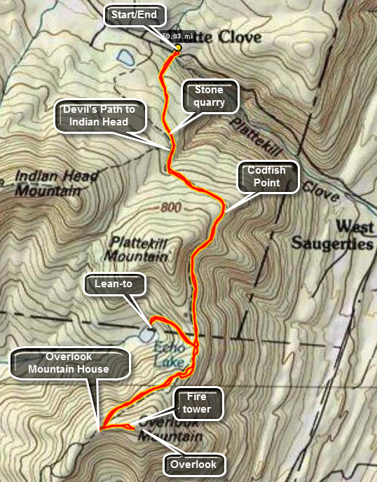
In Tannersville, find Platte Clove Road. Travel along this road until you find a pull-off on the
right for the Catskill Center Platte Clove Preserve. Parking here is limited. If there are no spaces,
continue for a short distance and turn into the Kaaterskill parking area on the left. Sign in at the trail
register. The first feature of the trail you will notice is a reconstruction of a post and tenon bridge
across the creek. The Catskill Center has provided "labels" for some of the trees and handy signs to
explain the role of the bluestone quarries in this area. After about a mile the red-blazed Devil's
Path begins on the left. Continue straight ahead on the blue-blazed Overlook Trail. In just .2 miles
you will be at the Devil's Kitchen lean-to. Another 2 miles brings you to the turn-off to Echo Lake.
This spur trail is blazed in yellow and is about .6 miles long. The descent and subsequent ascent
is steep and rocky. Echo Lake is a beautiful, natural lake surrounded by mountains. There is a lean-to
on the shore. Continue another 1.5 miles to the ruins of the Overlook Mountain Mountain House and the
WTZA-TV tower. The ruins are interesting and only the stone building blocks remain. A trail continues
.5 miles up to the Overlook Fire Tower. This tower sits on a prominent rock plateau. It offers
spectacular views of the Ashokan Reservoir, the Mountain House ruins and the surrounding hills and
valleys. Try to pick a clear day to that your view and the pictures you take are not cloudy by the haze
that can hang in the air. Return the same way you came for a round-trip of just under 11 miles.
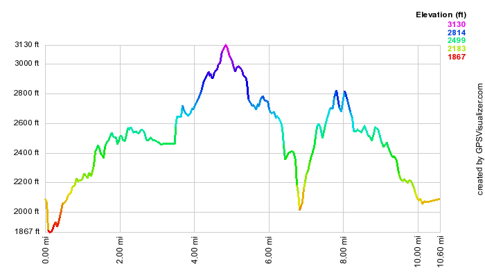 (The image at the left shows the profile of the hike. Remember that all vertical profiles are
relative!)
(The image at the left shows the profile of the hike. Remember that all vertical profiles are
relative!)
Overlook Mountain: Meades Mountain Road
| Quick Look | ||||
|---|---|---|---|---|
| Difficulty | Round trip | Total climb | Internet Maps | |
| 4.7 mi. | 1409 ft. | AllTrails | ||
 There are two trails that lead to Overlook Mountain and the sites found there. One trail comes up from
Meads Road and is about 5 miles or less round trip. This trail is actually an access road to the
WTZA-TV transmission tower and the state fire tower at the top of the mountain. The trail described
Here starts at or near the Kaaterskill PA and then continues across The Catskill Center Platte Clove
Preserve. This trail is almost 11 miles long round trip but offers the opportunity to visit
Echo Lake.
There are two trails that lead to Overlook Mountain and the sites found there. One trail comes up from
Meads Road and is about 5 miles or less round trip. This trail is actually an access road to the
WTZA-TV transmission tower and the state fire tower at the top of the mountain. The trail described
Here starts at or near the Kaaterskill PA and then continues across The Catskill Center Platte Clove
Preserve. This trail is almost 11 miles long round trip but offers the opportunity to visit
Echo Lake.
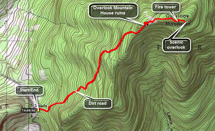
Finding the trailhead for the Meades Mountain Road route may be the hardest part of the hike. Head south and east from Phoenicia on Route 28. In about 4 miles turn east on Route 212. Route 212 heads generally east. Just passed Cooper's Lake turn left on Church Road. At the T turn left and then turn/bear right on Meades Mountain Road which may also be marked McDaniel Road. Drive for about 2.5 miles until a parking area appears on the left. Park your car and get on the access road to the tower. After walking about 1.75 miles on the road, the ruins of the Overlook Mountain House will be straight ahead. Look around the ruins. When done continue on the trail on the other side. The trail from Platte Clove and Echo lake will come in on the left. In about .4 miles you will be at the cabin. Turn left to go to the fire tower. On the way back walk behind the cabin and walk to the viewpoint that give Overlook Mountain its name. Follow the road back to your car.
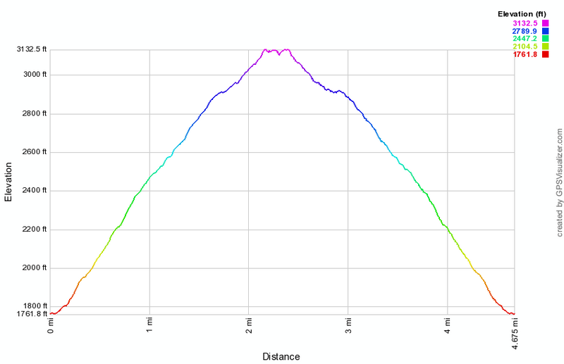 (The image at the left shows the profile of the hike. Remember that all vertical profiles are
relative!)
(The image at the left shows the profile of the hike. Remember that all vertical profiles are
relative!)