Twin Mountain
Twin is often climbed in conjunction with Indian Head. The more adventuresome and fit may also include Sugarloaf. Twin has some of the most beautiful views in the Catskills.
| Trailhead Coordinates | |
|---|---|
| Name | Coordinates |
| Prediger Road | N42.1339 W74.1043 |
| Roaring Kill | N42.1512 W74.1315 |
| Platte Clove | N42.1338 W74.0819 |
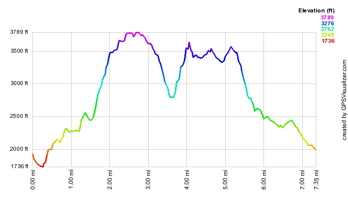
| Quick Look - Twin from Prediger Rd | ||||
|---|---|---|---|---|
| Difficulty | Round trip | Total climb | Location | Internet Maps |
| 6.1 mi. | 1850 ft. | N42.1161 W74.1150 | AllTrails | |
Turn onto Bloomer Rd. off Route 23A just west of Tannersville. At the Y in the road bear left onto
Platte Clove Rd. Continue on this road for about 3.75 miles and turn right on Prediger Rd. Go to the end
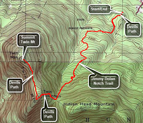
of the road and turn right onto the access road to the parking area. The red Devil's Path begins at the Prediger Rd PA. Get on the red-blazed Devil's Path
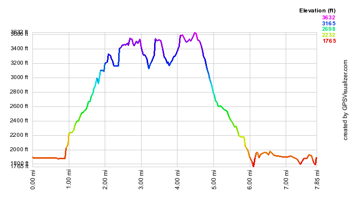
and hike .25 miles to the junction with the Jimmy Dolan Notch Trail. Bear right on the blue Jimmy Dolan Notch Trail and hike 1.35 miles to Jimmy Dolan Notch which is the col between Indian Head and Twin Mountains. The trail starts out gaining elevation gradually and then becomes steeper and rockier as you approach the notch. The last .3 miles ascends at a 27% grade. Turn right on the red Devil's Path and begin the ascent of Twin Mountain hiking another .3 miles at a 27% grade until the trail levels. Be sure to watch for a lookout on the left side of the trail which has great views of the Hudson River, Indian Head Mountain and the Catskill Community. The Devil's Path breaks out onto the southern peak of Twin where there are more great views. Continue on the Devil's Path for another .65 miles to the higher, northern peak of Twin which also has good views. This part of the hike is the easiest as the descent and subsequent ascent are minimal. When you are done turn around and retrace your route back to the Prediger Road parking area. This time the walk is mostly downhill!
| Quick Look - Indian Head and Twin from Kaaterskill PA | ||||
|---|---|---|---|---|
| Difficulty | Round trip | Total climb | Location | Internet Maps |
| 9.2 mi. | 2700 ft. | N42.1161 W74.1150 | AllTrails | |
Turn onto Bloomer Rd. off Route 23A just west of Tannersville. At the Y in the road bear left onto Platte Clove Rd. Continue on this road passed the Catskill Bruderhof and pull into the parking Lot for Kaaterskill High Peak. Walk back down the access road and take a right on Platte Clove Rd. Walk a short distance to the Platte Clove Preserve owned by the Catskill Center. Get on the aqua-blazed trail which is part of the Long Path. Follow this for .95 miles to the junction with the Overlook Trail and the Devil's Path. Turn right on the red-blazed Devil's Path. Ascend 1.25 miles through some steep areas to a lookout to the north. From here you can see the profile of Kaaterskill High Peak and a view of the Bruin. Continue on the trail for another .5 miles and get the view from another spectacular lookout. The peak of Indian Head Mountain (3573 ft.) is another .65 miles ahead. At this point you can retrace your route or continue down the other side to Jimmy Dolan Notch. At the notch you can turn back to the parking area or climb Twin Mountain. The best choice is to do Twin while you are there.
Follow the Devil's Path for .4 miles until you arrive at Jimmy Dolan Notch. Continue straight ahead
and up. The east summit of Twin Mountain is .4 miles ahead. At this point you will walk out onto a flat
rock prominence which gives a wonderful view of the valley below and includes Indian Head, Sugarloaf
and Plateau Mountains. In another .7 miles you will be at the summit of Twin Mountain (3640 ft.) Take
in the view an then turn around an return the 1.5 miles to Jimmy Dolan Notch. Now turn left on the
blue-blazed Jimmy Dolan Notch Trail and walk 1.2 miles downhill to an old logging road. In another
.4 miles, after you walk through the new parking area, you will be at the end of Prediger Road. Walk .2 miles to the end of Prediger Road
and turn right on Platte Clove Rd. Walk about 1 mile passed the Catskill Bruderhof and back to the
parking area.
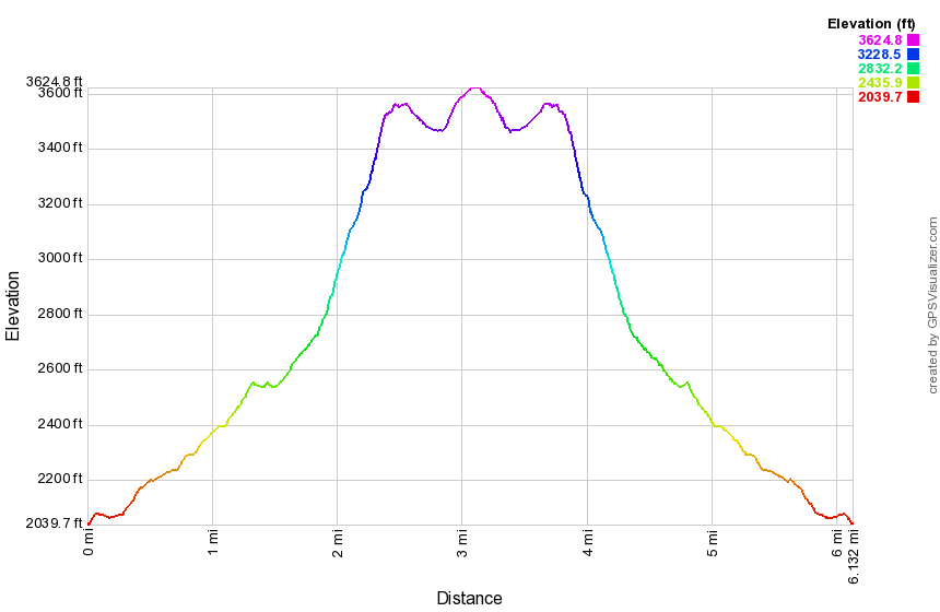
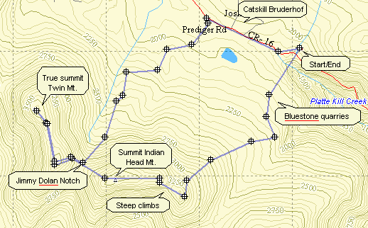
| Quick Look - Indian Head and Twin Loop from Prediger Road | ||||
|---|---|---|---|---|
| Difficulty | Round trip | Total climb | Location | Internet Maps |
| 8.4 mi. | 2590 ft. | N42 06.98 W74 06.90 | AllTrails | |
Turn onto Bloomer Rd. off Route 23A just west of Tannersville. At the Y in the road bear left onto
Platte Clove Rd. Continue on this road for about 3.75 miles and turn right on Prediger Rd. Go to the end
of the road and park on the right side obeying the signs the private landowner has posted. The Devil's Path
actually begins at the intersection of Prediger Rd and Platte Clove Road! Get on the red-blazed Devil's Path
and hike .25 miles to the junction with the Jimmy Dolan Notch Trail. Bear left staying on the Devil's Path.
After 1.5 miles turn left on the Overlook Road. Walk a short distance and turn right on the Devil's Path.
After 1.25 miles and several steep ascents there is a very nice lookout to the north. From here you can see the
Catskill Bruderhof with Kaaterskill High Peak behind it. Another .5 miles of ascent brings another lookout.
Continue for another .65 miles to the summit of Indian Head Mountain. Continue on a descent for .4 miles into
Jimmy Dolan Notch. Another .4 miles of steep climbing brings you to the east peak of Twin Mountain. The view
from this rock ledge on a clear day is hard to match anywhere in the Catskills. Since this peak is NOT the
highest on Twin, continue another .7 miles to "bag" the higher west peak. Retrace your footsteps to Jimmy
Dolan Notch. Turn left on the blue-marked Jimmy Dolan Trail. Continue following the markers for 1.6 miles
at which time the trail intersects the Devil's Path. Turn left and hike .25 miles back to the parking area.

| Quick Look - Indian Head and Twin from Prediger Road | ||||
|---|---|---|---|---|
| Difficulty | Round trip | Total climb | Location | Internet Maps |
| 6.8 mi. | 2270 ft. | N42 06.98 W74 06.90 | AllTrails | |
Turn onto Bloomer Rd. off Route 23A just west of Tannersville. At the Y in the road bear left onto
Platte Clove Rd. Continue on this road for about 3.75 miles and turn right on Prediger Rd. Go to the end
of the road and turn right onto the access road for the new parking area. The Devil's Path
actually begins at the intersection of Prediger Rd and Platte Clove Road! After parking in the new parking area, get on the red-blazed Devil's Path
and hike .25 miles to the junction with the Jimmy Dolan Notch Trail. Bear right on the Jimmy Dolan Trail.
Hike 1.6 miles to Jimmy Dolan Notch. Turn left and hike the .4 miles to the summit of Indian Head. Retrace
your steps back to the Notch and continue straight ahead on the red-marked Devil's Path. About .4 miles of
steep climbing brings you to the east peak of Twin Mountain. The view from this rock ledge on a clear day is
hard to match anywhere in the Catskills. Since this peak is NOT the highest on Twin, continue another .7 miles
to "bag" the higher west peak. Retrace your footsteps to Jimmy Dolan Notch. Turn left on the blue-marked Jimmy
Dolan Trail. Continue following the markers for 1.6 miles at which time the trail intersects the Devil's Path.
Turn left and hike .25 miles back to the parking area.
| Quick Look - Elka Park (Plateau, Sugarloaf, Twin) | ||||
|---|---|---|---|---|
| Difficulty | Round trip | Total climb | Location | Internet Maps |
| 8.3 mi. | 4440 ft. | N42 08.28 W64 10.48 | AllTrails | |
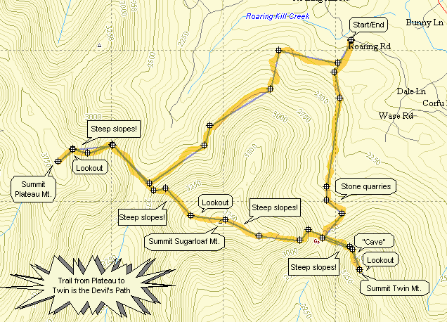 In Tannersville take Bloomer Road which is on the Hunter side of town. Continue on Bloomer until the
junction with Platte Clove Rd. Bear right here onto Elka Park Rd. Follow the signs to the trail head. The
road deteriorates quickly to dirt and the parking is limited. Take the yellow-blazed Roaring Kill trail
from the parking area. After only .25 miles this trail branches left to Pecoy Notch and right to the
Mink Hollow Trail. Turn right. The trail ascends gently through hardwood forests and, at times, over rock strewn areas.
It rolls some with a few ups and downs along the way. In more than one spot hikers have walked off the trail to get a
view or collect wood. Watch carefully that you stay on the main trail. In several spot there are views of Plateau
Mountain rising on your right. The mountain in quite impressive and this gives you some idea of the climb to come! One
lookout is especially nice and allows you to take pictures before a slight descent. Continue for about 2.5 miles to the
junction with the red-blazed Devil's Path.
In Tannersville take Bloomer Road which is on the Hunter side of town. Continue on Bloomer until the
junction with Platte Clove Rd. Bear right here onto Elka Park Rd. Follow the signs to the trail head. The
road deteriorates quickly to dirt and the parking is limited. Take the yellow-blazed Roaring Kill trail
from the parking area. After only .25 miles this trail branches left to Pecoy Notch and right to the
Mink Hollow Trail. Turn right. The trail ascends gently through hardwood forests and, at times, over rock strewn areas.
It rolls some with a few ups and downs along the way. In more than one spot hikers have walked off the trail to get a
view or collect wood. Watch carefully that you stay on the main trail. In several spot there are views of Plateau
Mountain rising on your right. The mountain in quite impressive and this gives you some idea of the climb to come! One
lookout is especially nice and allows you to take pictures before a slight descent. Continue for about 2.5 miles to the
junction with the red-blazed Devil's Path.
Turn right on the Devil's Path and be prepared for a long, hard climb up to Plateau. Continue for 1 mile and 1200 feet of vertical climb to the lookout near the summit of Plateau. The climb is strenuous with near vertical parts in places. Most of the trail has switchbacks to soften the ascent somewhat. Proceed onward for another .2 miles to the highest point on Plateau. There is little to see from this spot but it is the highest point on the mountain. Retrace your steps to the rock which allows a fine view of Sugarloaf Mountain in front of your and other peaks to the right and left. return to the parking area. When you have rested briefly, retrace your steps to the Mink Hollow trail and get ready for the ascent up Sugarloaf.
The ascent of the Devil's Path up Sugarloaf will remind you a lot of the ascent up Plateau. The vertical gain of 1200 feet is almost identical and the hiking distance is about the same. One mile and 1200 feet may not sound too impressive but the climb itself is quite a challenge made all the more challenging by your recent climb up Plateau. As you ascend and get near the top of the climb a large boulder acts as a lookout to Plateau and the other surrounding peaks and the valley below. This is even more open than the one on Plateau and so the view is better. Once you get to the summit of Sugarloaf there isn't much to see so continue on the Devil's Path toward Twin.
The Devil's Path leads down Sugarloaf and in about 1.2 miles you will be at Pecoy Notch. From here you can turn left on the Pecoy Notch trail and go back to the parking area. Since you are looking for more of a challenge, continue straight ahead on the Devil's Path. The distance is ONLY about .7 miles and the vertical gain is ONLY about 800 feet since Twin has the lowest elevation of the three mountains. These facts belie the difficulty that awaits. This short climb is one of the most challenging in the Catskills. The trail becomes steep almost immediately with several areas of open rock face to negotiate. In several other areas the trail seems to end until you look UP to see a marker almost directly above. These near vertical areas require some leg strength and upper body strength to push and pull your way up. Some views are available as you look over your shoulder back at Sugarloaf but you will be busy climbing and there are better views at the top.
Near the summit of the western peak of Twin the trail flattens and provides some relief from the difficult climb. In this area is a "cave" made by an overhanging rock ledge. Next to the cave the trail continues through a narrow passage which requires a good toehold and handhold to push and pull yourself up. The trail winds briefly and then reaches the summit on an open expanse of rock. This lookout provides GREAT views back to Sugarloaf and Pecoy Notch. In fact the view is very open for a 180 degree or more view of the entire area. The east peak of win is visible and Indian Head can be seen if you walk out onto the ledge. After taking some pictures and relaxing a little retrace your steps back down to Pecoy Notch. The way down is easier than up but still requires great care.
At the junction with the Pecoy Notch trail turn right to get back to the parking area. The trail starts as a scramble
over many rocks but softens as you move father down. In about .4 miles is a beaver pond on the left which offers views
back to Sugarloaf and Twin. In another .5 miles you arrive at Dibble's Quarry. here hikers have crate oversized chairs
out of the discarded bluestone that litters the area. This open area provides unobstructed views of Roundtop,
Kaaterskill High Peak and parts of the Hudson Valley. In .7 miles the trail ends at the Roaring Kill Trail. The parking
area is only .25 miles away!
| Quick Look - Indian Head, Twin and Sugarloaf Loop from Prediger Road | ||||
|---|---|---|---|---|
| Difficulty | Round trip | Total climb | Location | Internet Maps |
| 9.9 mi. | 4000 ft. | N42 06.98 W74 06.90 | AllTrails | |
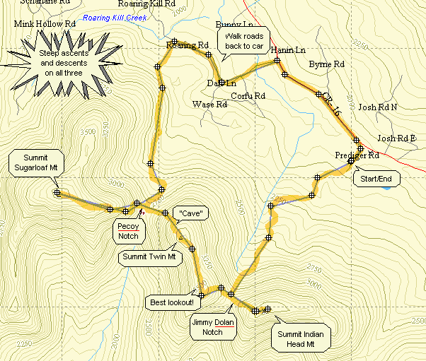
Turn onto Bloomer Rd. off Route 23A just west of Tannersville. At the Y in the road bear left onto Platte Clove Rd. Continue on this road for about 3.75 miles and turn right on Prediger Rd. Go to the end of the road and turn right onto the access road for the new parking area. The Devil's Path actually begins at the intersection of Prediger Rd and Platte Clove Road! After parking in the new parking area, get on the red-blazed Devil's Path and hike .25 miles to the junction with the Jimmy Dolan Notch Trail. Bear right on the Jimmy Dolan Trail. Hike 1.6 miles to Jimmy Dolan Notch.
Turn left and hike the .4 miles to the summit of Indian Head. Retrace your steps back to the Notch and continue straight ahead on the red-marked Devil's Path. About .4 miles of steep climbing brings you to the east peak of Twin Mountain. The view from this rock ledge on a clear day is hard to match anywhere in the Catskills. Since this peak is NOT the highest on Twin, continue another .7 miles to "bag" the higher west peak. This peak also has a nice view. Continue on the Devil's Path to your left. It leads down for about .5 miles to Pecoy Notch which is the gap or col between Twin and Sugarloaf.
Continue on the Devil's Path up Sugarloaf Mountain for about 1.1 miles. There is no view from the summit although
there is a lookout if you continue on toward Plateau. Turn around and retrace your steps to the notch. Here you may go
over Twin again and back to the car on the Jimmy Dolan Notch Trail. This is a hard go so turn left on the blue blazed
Pecoy Notch Trail. Walk 1.5 miles to the junction with the Roaring Kill Trail and take this trail for about .4 miles to
the parking area. Unfortunately, your car is back on Prediger Road. Turn right on Roaring Kill Rd., left when it joins
Dale Lane, right onto Platte Clove Road and then right onto Prediger. This whole distance is about 2.7 miles but it is
flat and fast compared to the trek back over Twin!

| Quick Look - Sugarloaf and Twin T from Roaring Kill | ||||
|---|---|---|---|---|
| Difficulty | Round trip | Total climb | Location | Internet Maps |
| 7.4 mi. | 3030 ft. | N42 06.98 W74 06.90 | AllTrails | |
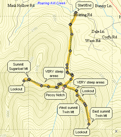
Turn onto Bloomer Rd. off Route 23A just west of Tannersville. At the Y in the road bear left onto Platte Clove Rd. Continue on this road until the sign for Elka Park Road appear on the right. Turn here and proceed on this road without turning until it turns into a dirt road. After about a mile the Roaring Kill Parking Area appears on the right. Park here and get ready for a challenging but rewarding hike. The Roaring Kill Trail heads into the woods for only .25 miles and then splits into the Pecoy Notch Trail and the Mink Hollow Trail. Turn left here onto the blue marked Pecoy Notch Trail. This trail begins a climb through pine forests as it works its way to the Col between Sugarloaf and Twin.
After .7 miles, you arrive at Dibble's Quarry which has nice views of Roundtop, Kaaterskill High Peak and the Hudson River valley. This is the remains of one of the numerous bluestone quarries that were active in the area. Hikers have piled the flat rocks into chairs and tables and thrones and walls making for a very interesting appearance. This area keeps changing as people add to the artistry. In another half mile the trail passes a beaver pond and can be quite muddy and even flooded at times. From here the trail climbs the last half mile to Pecoy Notch. You can choose to hike Twin or Sugarloaf or do both! If you choose to do both, it really doesn't matter which you choose first.
Turn right on the Devil's Path to climb Sugarloaf Mountain. The distance is only 1.3 miles but the climb is rugged for almost a mile. There are lots of rock scrambles and several areas that test your balance, agility and upper body strength. Near the summit the trail levels as you walk toward the summit. From the summit continue on the Devil's Path for less than a half mile. Look for a side trail on the left that leads to a designated campsite and great views to the north. Retrace your steps back down to Pecoy Notch.
The climb up the west side of Twin Mountain is one of the steepest I have hiked. Some areas are nearly vertical requiring you to pull yourself up by gripping roots and rocks. The climb is less than a mile but most of it is VERY STEEP. Just before the western (higher) summit there is an interesting "cave" or rock overhang on the left of the trail. The trail continues to the right of this overhang up through some cracks in the rock. The view from the top is always worth the climb. It is better on the days when there is less haze. Continue on the trail for another .7 miles to the eastern (lower) peak of Twin. The views here are perhaps even better than on the higher peak. There is a large rock shelf which offers great views of the western peak of Twin, Sugarloaf and Overlook Mountain.
The return trip consists of turning around and following the Devil's Path back to Pecoy Notch. Turn right and follow the Pecoy Notch and Roaring Kill Trail back to the parking area.