| Pick a Catskill 35 Peak: |
Balsam Mountain
Balsam is often done in conjunction with Eagle. Several approaches are possible with the shorter ones being steep and the gentler climbs being long. This Balsam is one of three 3550's with Balsam in its name.
| Trailhead Coordinates | |
|---|---|
| Name | Coordinates |
| McKinley Hollow | N42.0710 W74.4740 |
| Rider Hollow | N42.1019 W74.5170 |
| Lost Clove | N42.1058 W74.4701 |
| Biscuit Brook | N41.9911 W74.4849 |
| Segar Hollow | N42.0579 W74.5390 |
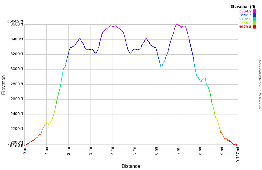
| Quick Look - Eagle and Balsam from McKenley Hollow | ||||
|---|---|---|---|---|
| Difficulty | Round trip | Total climb | Location | Internet Maps |
| 8.8 mi. | 2910 ft. | N42.0908 W74.4886 | Alltrails | |

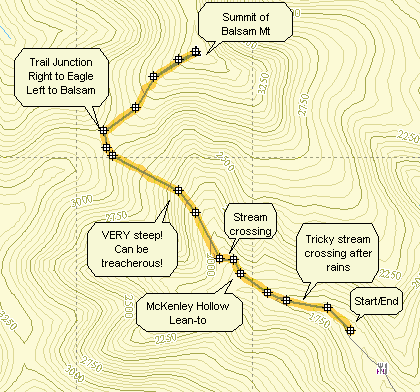
Take the Claryville Rd. north from Rt. 55 in Curry outside of Grahamsville. Just short of Claryville turn left onto the Frost Valley Rd. Pass the Frost Valley YMCA camp and continue on passing the Big Indian and Slide Mt. trail heads of the right and the Panther Mt. Parking area at the hairpin turn on the left. Look for McKenley Hollow Rd. on the left. You may also come in from Rt. 28 in Big Indian and look for McKenley Hollow Rd. on your right. Turn here, drive to the end of the road and pull into the parking area.
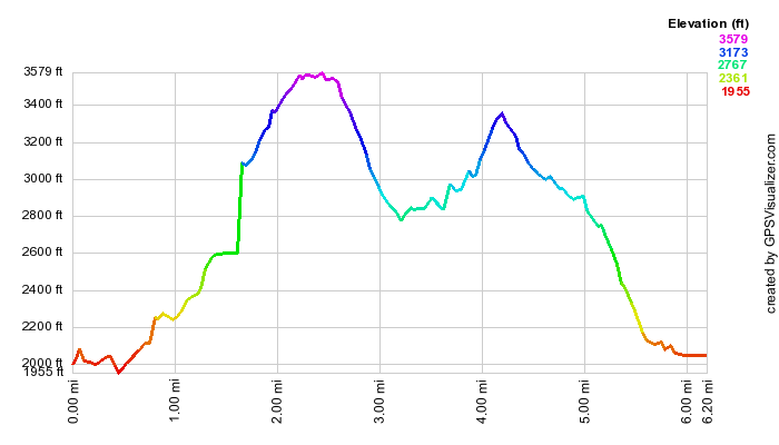
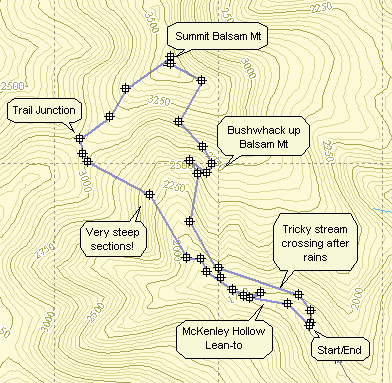
Walk up the road and look for the red-blazed Oliveria-Mapledale trail on the left. Turn onto this trail and cross a bridge over a stream. There are two MORE water crossings that do NOT have bridges and can be tricky after it has rained. In .6 miles you will be at the lean-to. Pass the lean-to and watch as the trail turns left and crosses the stream. Continue for another 1.15 miles on this trail at which point it crosses the blue-blazed Pine Hill-West Branch Trail. This trail is VERY STEEP in places and can be interesting both ascending and descending! It is also lined with nettles during the spring and summer.
Turn left on the blue-blazed trail. Stay on this trail for 2.15 miles to reach the summit of Eagle Mt. (3600 ft.).
You will also pass over Haynes Mt. which falls only 80 ft. short of being 3500. Turn around and
backtrack along the blue-blazed trail to the junction with the red-blazed Oliveria-Mapledale trail. Turn
right to return to the parking area. Continue straight ahead for .75 miles to the summit of Balsam Mt.
(3600 ft.). Turn around and retrace your route to the red-blazed trail. Turn left and hike 1.85 miles
back to the parking area.
| Quick Look - Balsam from McKenley Hollow | ||||
|---|---|---|---|---|
| Difficulty | Round trip | Total climb | Location | Internet Maps |
| 4.6 mi. | 1877 ft. | N42 05.45 W74 29.30 | Alltrails | |
Take the Claryville Rd. north from Rt. 55 in Curry outside of Grahamsville. Just short of Claryville turn left onto the Frost Valley Rd. Pass the Frost Valley YMCA camp and continue on passing the Big Indian and Slide Mt. trail heads of the right and the Panther Mt. Parking area at the hairpin turn on the left. Look for McKenley Hollow Rd. on the left. Turn here and pull into the parking area near the end of the road. Look for the red-blazed Oliveria-Mapledale trail. Continue for 1.85 miles on this trail at which point it crosses the blue-blazed Pine Hill-West Branch Trail. The trail up from the parking area is steep at times and lined with nettles during the summer. Turn right on the blue-blazed trail Stay on this trail for .75 miles to reach the summit of Balsam Mt. (3600 ft.). Turn around and backtrack along the blue-blazed trail to the junction with the red-blazed Oliveria-Mapledale trail. Turn left to return to the parking area. Continue straight ahead for 2.15 miles to the summit of Eagle Mt. (3600 ft.). Turn around and retrace your route to the red-blazed trail. Turn right and hike 1.85 miles back to the parking area.

| Quick Look - Balsam from Rider Hollow | ||||
|---|---|---|---|---|
| Difficulty | Round trip | Total climb | Location | Internet Maps |
| 6.2 mi. (4.7 mi. w/o side trip to Belleayre | 2188 ft. | N42 03.70 W74 30.62 | Alltrails | |
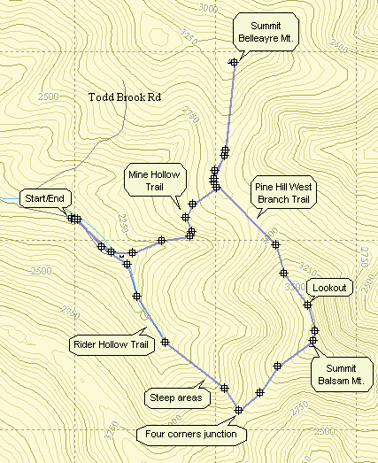
From Route 28 in Arkville take Dry Brook Road toward Mapledale. There are other possibilities but this may be the easiest the first time. Continue on Dry Brook Road until the hamlet of Mapledale. Turn left on Todd Mountain Road. Bear to the left when Baker Road goes slightly right. Pass over the bridge and take the next right. This road is not marked but is Rider Hollow Road. If you need to ask for directions, mention the Hardenburgh Town Hall! Continue on this road as it narrows and becomes a dirt road. Park in the parking area at the end.
The map shows a loop hike with a side trip to Belleayre. The summit of Belleayre is a field with no view. You may leave this part out or hike out to the ski slopes. The latter is well worth the extra time and distance! The loop can be done in either direction or it could be turned into an out and back. The description here uses the Oliveria Mapledale Trail to go up and the Mine Hollow Trail to return.
Sign in at the trail register and get on the red Oliveria Mapledale Trail. This trail is wide at this point and follow Todd Brook for a distance. Soon you will pass over the brook on a wooden bridge. After less than .5 miles, you will be at the junction with the Mine Hollow Trail. Turn right and go back over the brook on an interesting steel bridge. At .5 miles there is a lean-to. The trail continues crossing over the brook at least 4 times! When the water is higher, some of these crossings could be a problem! After the third crossing, the trail starts to get steep and the ever-present nettles begin to close in. Following the fourth crossing, the trail get even more rugged until it levels as it approaches the four corners trail junction in the col between Balsam and Eagle. Turn left on the blue blazed Pine Hill West Branch Trail.
This trail climbs Balsam Mountain without too many steep areas. Within .7 miles you are at the highest point on the mountain. There is little to mark your accomplishment and if you turn around at this point you will miss a nice lookout. Continue on this trail. Do not be fooled by the many dead end side trails. You will be tempted by many glimpses through the trees. The lookout is very obvious and just off the trail as you begin to descend. After the lookout the trail descends into a flat Col between Balsam and Belleayre. The yellow markings of the Mine Hollow Trail and a sign soon appear. From here you may turn left and return to the car or you may go straight ahead to explore Belleayre.
The Mine Hollow Trail may be the easiest way up to Balsam and Belleayre. The trail has areas covered by a green vine and is never very steep. It is possible to descend VERY quickly. In addition, there is only one water crossing without a bridge over a very small tributary of Todd Brook. After 1 mile you will be back at the trail junction by the steel bridge. Another .3 miles puts you back at the parking area.
| Quick Look - Balsam bushwhack from McKenley Hollow | ||||
|---|---|---|---|---|
| Difficulty | Round trip | Total climb | Location | Internet Maps |
| 4.8 mi | 2140 ft. | N42 03.70 W74 30.62 | Alltrails | |
Take the Claryville Rd. north from Rt. 55 in Curry outside of Grahamsville. Just short of Claryville turn left onto the Frost Valley Rd. Pass the Frost Valley YMCA camp and continue on passing the Big Indian and Slide Mt. trail heads of the right and the Panther Mt. Parking area at the hairpin turn on the left. Look for McKenley Hollow Rd. on the left. You may also come in from Rt. 28 in Big Indian and look for McKenley Hollow Rd. on your right. Turn here, drive to the end of the road and pull into the parking area.
Walk up the road and look for the red-blazed Oliveria-Mapledale trail on the left. Turn onto this trail and cross a
bridge over a stream. There are two MORE water crossings that do NOT have bridges and can be tricky after it has rained.
In .6 miles you will be at the lean-to. Pass the lean-to and watch as the trail turns left and crosses the stream. At this point continue on a path or woods road heading north and up. Since this is a bushwhack there is no trail to follow. Watch your compass and map or GPS to keep on the correct heading. Watch your step and look ahead to avoid cliff and ledges. At the top of Balsam you should be able to pick up the blue trail. Turn left on this trail and descend about .75 miles to the col between Balsam and Eagle. Turn left onto the red Oliveria-Mapledale Trail and hike 1.85 miles back to the parking area.

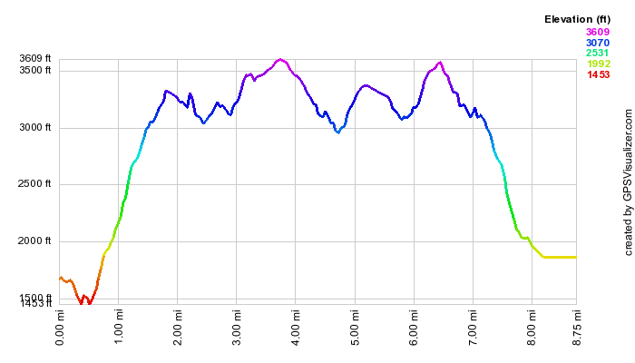
| Quick Look - Eagle and Balsam from Rider Hollow | ||||
|---|---|---|---|---|
| Difficulty | Round trip | Total climb | Location | Internet Maps |
| 9.7 mi. | 2880 ft. | N42.0619 W74.5097 | AllTrails | |
From Route 28 in Arkville take Dry Brook Road toward Mapledale. There are other possibilities but this may be the easiest the first time. Continue on Dry Brook Road until the hamlet of Mapledale. Turn left on Todd Mountain Road. Bear to the left when Baker Road goes slightly right. Pass over the bridge and take the next right. This road is not marked but is Rider Hollow Road. If you need to ask for directions, mention the Hardenburgh Town Hall! Continue on this road as it narrows and becomes a dirt road. Park in the parking area at the end.
Out of the parking area take the red Oliveria Mapledale Trail. At .5 miles bear right to stay on the OM Trail which gains 1020 feet over the next 1.3 miles averaging a 14% grade. At 1.9 miles turn right on the blue Pine hill-West Branch Trail. You will be headed toward Eagle mountain as your goal but mist climb over Haynes Mountain first. At 2.6 miles you will be at the top of Haynes and will descend the other side before climbing Eagle. It is 1.5 miles from the summit of Haynes to the summit of Eagle at 4 miles into the hike. A short path leads to the right or north to the canister. Turn around and hike back to the junction with the Oliveria Mapledale Trail. If you just want Eagle, turn left and walk back downhill to your car. Continue straight ahead on the Pine Hill-West Branch Trail toward Balsam Mountain. From the junction it is about .7 miles to the summit of Balsam after gaining 555 feet on a 16% grade. Watch carefully for a nice lookout on the right side of the trail. Continue on the Pine Hill-West Branch Trail for 1.3 miles walking downhill along the Catskill Divide dropping 800 feet of elevation. At 8.25 miles turn left on the yellow Mine Hollow Trail. Walk another mile downhill losing another 785 feet to the junction with the Oliveria Mapledale Trail. Turn right and walk out to the parking area.