| Pick a Catskill 35 Peak: |
Friday Mountain
Friday is often climbed in conjunction with Balsam Cap. Although not one of the tallest peaks, Friday can be the peak with the greatest vertical climb depending on the route you take. There are areas of steep rock faces and dense evergreens. The way between the two peaks is not easy. For me this was one of the most difficult hikes.
| Trailhead Coordinates | |
|---|---|
| Name | Coordinates |
| Moonhaw Road | N41.9847 W74.3278 |
| Denning PA | N41.9654 W74.4527 |
| Peekamoose Road | N41.9150 W74.4290 |
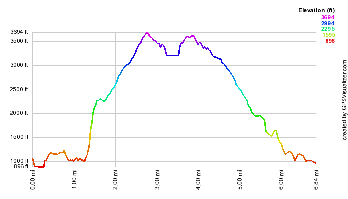
| Quick Look - Balsam Cap and Friday from Moonhaw Road | ||||
|---|---|---|---|---|
| Difficulty | Round trip | Total climb | Location | Internet Maps |
| 5.5 mi. | 2867 ft. | N41.9769 W74.3578 | AllTrails | |
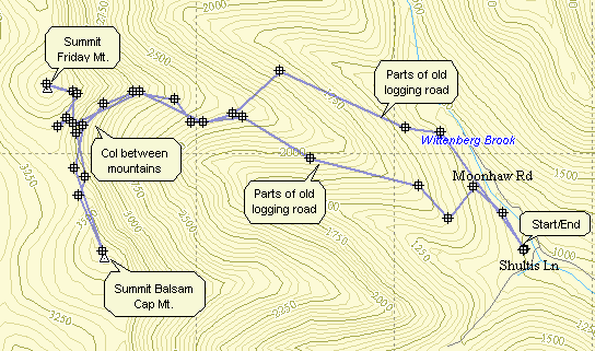
Turn onto Route 52A near the TriValley School. Stay on the road until the hamlet of Sundown where
the road turns left. Bear to the right on Peekamoose Rd. and continue on the road looking for Moonhaw Rd.
on the left. Turn onto Moonhaw Rd. and drive to the end. Park on the right just before the gates to the private driveway. Cross the road and start up toward Friday in a generally westward direction. If you hit a woods road, follow it until it strays too far off course and then duck into the woods and bushwhack toward Friday. You may find some well-defined herd paths but be sure to keep checking you bearing. If you come near a cabin, STAY AWAY since this is private property. Some damage has been done to the cabin over the years and the owners understandably are not thrilled with visitors. As you pass through this area sneak a peak at the views of the Ashokan, the surrounding hills and the valley below which are stunning. From the cabin you will have to push through some bushes but if you are lucky you will find a herd path beyond. Some people like to hike directly to the Friday ledges and find a way up and through. You may also head to a point just south of the Friday peak. In either case. the climb gets steeper as you approached Friday. You may hit some flatter ground but at some point you will see the cliff band of Friday before you. Walk along the cliff bands looking for a way up and ascend where you can. You will probably be confronted by more cliffs and have to work your way through those. Once on top of the cliffs look for a herd path. and follow it. Push through the brush as you continue toward the canister. Keep watching for well-worn paths that lead to the canister which is probably NOT at the highest point on the mountain. Signed in at the canister and then start back along the herd path toward Balsam Cap. The herd path takes you to the col between the two peaks where there is a small, cleared area and a fire ring. The herd path continues on, sometimes VERY prominent and at others times not so easy to find. Stay near the edge of the ridge. Along the way you may pass by some cliff bands which are impressive but nothing compared to the ones on Friday! As you get close to Balsam Cap it seems like you should cut up through the woods toward higher ground and this will work. Try to stay on the herd path since it soon cuts up to the summit. It is steep but easy to follow and goes right to the summit. Find the canister and sign. Follow the herd path back to the col and look for a lower path that heads down below some more cliffs. This route will take you back in the direction of the route you used to ascend Friday. If you would like to try to find the B52 crash, continue on the herd path for less than .1 miles at which point you should be almost directly west of the crash. Now it is a matter of walking DOWN to the wreck on VERY steep terrain. The crash is about .25 miles away but the vertical drop is 500 feet! The plane is the largest wreck in the Catskills and is spread over a large area. The forward part of the fuselage is largely intact. The star which was the marking of the Army Air Corps is faded but recognizable. Both engines or parts of them are present and one still has the propeller attached. The best way back is to walk uphill slightly and almost due north. If you head downhill slightly and more west northwest you can avoid some of the climb. Eventually you may rub across the path from earlier in the hike. Just follow the herd paths and roads back toward the car and through in a bushwhack when they don't go in the right direction.