| Pick a Catskill 35 Peak: |
Kaaterskill High Peak
This mountain is the one whose profile is most recognizable thanks to the numerous paintings by Thomas Cole. It has several approaches with trails that lead to a snowmobile trail that rings the actual peak. The final climb is over an obvious but steep herd path.
| Trailhead Coordinates | |
|---|---|
| Name | Coordinates |
| Platte Clove | N42.1338 W74.0819 |
| Palenville (Route 23A) | N42.1766 W74.0372 |
| Palenville (Harding Road) | N42.1763 W74.0304 |
| Gillespie Road | N42.1714 W74.1136 |
| Quick Look - High Peak from Platte Clove | ||||
|---|---|---|---|---|
| Difficulty | Round trip | Total climb | Location | Internet Maps |
| 7.2 mi. | 1785 ft. | N42.1619 W74.0806 | AllTrails | |
Turn onto Bloomer Rd. off Route 23A just west of Tannersville. At the Y in the road bear left onto
Platte Clove Rd. Continue on this road passed the Catskill Bruderhof and pull into the parking lot for
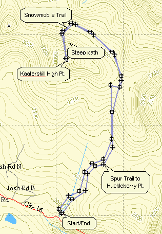
Kaaterskill High Peak. Look for the aqua-blazed Long Path. Follow this trail for 1.05 miles where the
Huckleberry Point trail goes off to the right. Stay on the Long Path as it winds its way up the mountain
for another 2.1 miles. This route goes around to the north side of the mountain where a very obvious
path leads up to the loop snowmobile trail that goes around the peak. Make a right on the snowmobile trail
and look for a well-traveled path to the left. This will take you the .5 miles to the top. At the very
summit of the High Peak (3655 ft.) there is no view. If you walk off to the east or south views open up
in both directions. To return to the parking area retrace your route. There are several ways to cut the
distance to the High Peak by bushwhacking but they don't really cut the time needed to scale the peak.
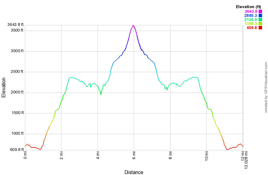
(The image above is the vertical profile for entire hike so it has a symmetrical appearance. Much of the trail is a level area near the summit that takes you around to the north side of the mountain. The distance makes the final climb to the peak look gentle. This is one of the steepest climbs in the Catskills over an unmaintained trail.)
| Quick Look - High Peak and Huckleberry Point from Platte Clove | ||||
|---|---|---|---|---|
| Difficulty | Round trip | Total climb | Location | Internet Maps |
| 11.0 mi. | 2850 ft. | N42.1619 W74.0806 | AllTrails | |
Turn onto Bloomer Rd. off Route 23A just west of Tannersville. At the Y in the road bear left onto Platte Clove Rd. Continue on this road passed the Catskill Bruderhof and pull into the parking lot or Kaaterskill High Peak. Look for the aqua-blazed Long Path. Follow this trail for 1.05 miles where the Huckleberry Point trail goes off to the right. Stay on the Long Path as it winds its way up the mountain for another 2.1 miles. This route goes around to the north side of the mountain where a very obvious path leads up to the loop snowmobile trail that goes around the peak. Make a right on the snowmobile trail and look for a well-traveled path to the left. This will take you the .5 miles to the top. At the very summit of the High Peak (3655 ft.) there is no view. If you walk off to the east or south views open up in both directions especially from Hurricane Ledge. Begin your return by carefully working your way down the herd path to the snowmobile trail. Turn right on the snowmobile trail and then left on the snowmobile trail and, finally, then right on the Long Path. Walk 2.3 miles for a long time and downhill on the Long Path to the junction with the yellow Huckleberry Point Trail. Turn left and walk about 1.3 miles to the lookout. You will probably want to spend some time looking around since there are several viewpoints that give different angles and views. Follow the Huckleberry Point Trail back to the Long Path. Turn left on the Long Path and walk the last mile back to the parking lot.
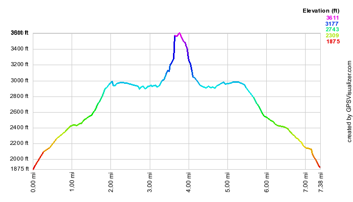
(The image above is the vertical profile for entire hike so it has a symmetrical appearance. Much of the trail is a level area near the summit that takes you around to the north side of the mountain. The distance makes the final climb to the peak look gentle. This is one of the steepest climbs in the Catskills over an unmaintained trail.)
Another way to climb the High Peak is to start in Palenville on Route 23A. This is a more difficult route but has MANY more point of interest along the way. This trail is part of the Long Path stretching from Fort Lee, NJ to Thacher Park near Albany. Poet's Ledge, Wildcat Falls and Buttermilk Falls are points of interest on the trail. The trail leads to the snowmobile trail that run around Kaaterskill High Peak and Round Top. A herd path from the snowmobile trail leads up to the High Peak.
| Quick Look - High Peak from Palenville | ||||
|---|---|---|---|---|
| Difficulty | Round trip | Total climb | Location | Internet Maps |
| 12.1 mi. 12.5 mi with Hurricane 13.5 mi with Poet's and Hurricane |
4290 ft. | N42 09.73 W74 04.83 | AllTrails | |
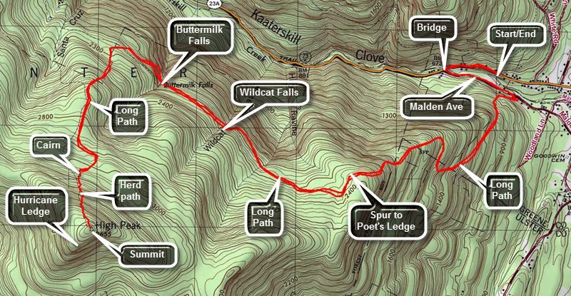
Parking in this area can be a problem. The safest parking area is on Route 23A about .2 miles west of Whites Road or .35 miles east of the bridge over Kaaterskill Creek at Malden Ave. where the Long Path meets the road. There are other legal parking areas west of the bridge but parking along Route 23A is ILLEGAL and DANGEROUS! From the east (Palenville), take Route 23A from Palenville toward Haines Falls and watch for Whites Road on the right or north side of the road. In .2 miles there will be a small parking area on the right or north where the Long Path crosses the road. From the west (Haines Falls), drive down the hill passing Kaaterskill Falls. As the hill begins to level, you will drive across a bridge that spans Kaaterskill Creek. Drive another .35 miles and watch for a parking area on the left or north side of the road where the Long Path meets the road. From the parking area walk west on Route 23A to the bridge over Kaaterskill Creek and turn left on Malden Ave. Much of the land along the first mile or so of the hike are located on a right-of-way across private property so hikers should stay on Malden Ave. and the marked trail after it. Watch for the aqua blazes of the Long Path and blue hiking disks. This street is now blocked and closed to traffic. It has been overgrown with vegetation and only the paved surface here and there separates it from any other trail. On the other end of this short path you will be back on paved road. The blazes will continue for a short distance and the direct you to turn up a short street/driveway. Blue markers now appear in addition to the blaze. After a few feet, the trail turns onto a woods road and into the forest.
The path ascends on the woods road, leveling at times, but always continuing upward. After less than a mile, the trail again cuts right and starts a serious climb up! The trail has several switchbacks and there are hints of views to the right. Continue on this trail which levels at times and then becomes much steeper. In about 1.6 miles there is an obvious lookout to the right. The lookout gives a glimpse of the Clove below and the mountains to the north. Continue on the main path for another half mile. At this point a sign points to a yellow spur trail that DESCENDS to Poet's Ledge. The descent is definitely worth it since the view is very nice but Poet's Ledge is NOT included in this hike. Continue on the main trail toward Hillyer, Wildcat and Buttermilk Falls. Each of these is more impressive than the next. How impressive they all are depends on the volume of water flowing over them. Each offers a glimpse of the other side of the clove. In fact, this entire part of the trail is relatively flat and there always seems to be an elusive glimpse of the clove off to your right.
After the last falls the trail turns south-southwest and begins to ascend again. Some of these ascents are steep and over rocky areas. The trail cuts back and forth to make the climb easier. In a short distance the trail makes a sharp turn to the right. Hike a short distance up this trail to the snowmobile trail that loops around Kaaterskill High Peak and Round Top Mountain. Turn right on the loop trail. In just a short distance you will see a WELL-DEFINED herd path marked with a stone cairn on your left. Get ready for a short but STEEP climb up to the High Peak. This climb REQUIRES crampons of microspikes in the winter as many people have been injured ascending and descending this steep path. The summit is marked by a USGS seal. Unfortunately, there is NO VIEW from the top. Although this is already a long hike, a visit to Hurricane Ledge is considered a must. Follow the paths that lead southwest from the summit clearing. The paths are well-defined but not marked. The walk is less than .2 miles. DO NOT give up until you are on a wide open viewpoint looking south and southwest toward the Devil's Path and all the peaks along it! When you have taken in the view, turn around and walk back to the summit. The best thing about the long climb to the High Peak is that the return trip is almost all downhill! Reverse your route from the ascent and enjoy the trip down!