
Finger Lakes Trail
Besides the thirty-five 3500 foot peaks in the Catskills, there are many other smaller mountains to climb. In addition, there are hundreds of miles of trails to hike. There are also MANY other places to hike also. I have divided the Trails section into list of All Trail, the Catskills, the Shawangunks, Bear Mt/Harriman, East Hudson, West Hudson, New Jersey and Other Trails. The All Trails list includes over 400 different trails and may load slowly on your computer. The "divided" list should load more quickly.
You can view all the Trails here.
Clicking on ![]() will bring up an index of trails. Clicking on
will bring up an index of trails. Clicking on ![]() will return you to the top of the page.
will return you to the top of the page.
The Finger Lakes Trail is a primitive footpath that starts in Allegheny State Park on the New York - Pennsylvania border and extends 576.5 miles to end in the Catskill Park at the beginning of the Table Peekamoose Trail off the Phoenicia East Branch Trail near the Denning trailhead. There are other side trails which increase the length of the trail system. Four hundred miles of this trail is also part of the Scenic North Country Trail. The Finer Lakes Trail Conference celebrated its 50th Anniversary on June 2, 2012. To commemorate the occasion the Conference set up a series of hikes that would cover the entire length of the trail. Hikes varied in length and difficulty from 4 to 14 miles. The Trail Conference continues to improve the trails and to move sections from roads to trails. The trails included here have parts that are no longer included in the main trail. They are included here since at some point I hiked them when they were part of the main Finger Lakes Trail.
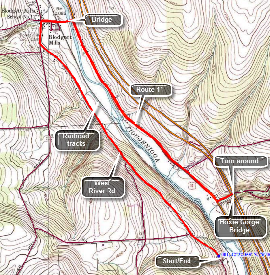
Finger Lakes Trail: West River Rd to Hoxie Gorge
| Quick Look | ||||
|---|---|---|---|---|
| Difficulty | Round trip | Total climb | Internet Maps | |
| 10.0 mi | 780 ft. | AllTrails | ||
 The Finger Lakes Trail is a primitive footpath that starts in Allegheny State Park on the New York - Pennsylvania border and extends 576.5 miles to end in the Catskill Park at the beginning of the Table Peekamoose Trail off the Phoenicia East Branch Trail near the Denning trailhead. There are other side trails which increase the length of the trail system. Four hundred miles of this trail is also part of the Scenic North Country Trail. The Finer Lakes Trail Conference celebrated its 50th Anniversary on June 2, 2012. To commemorate the occasion the Conference set up a series of hikes that would cover the entire length of the trail. Hikes varied in length and difficulty from 4 to 14 miles. The Trail Conference continues to improve the trails and to move sections from roads to trails.
This hike is best done with a car spot since it is 5 miles one way for a total of 10.0 miles. The route described here is strict out and back without any variations. Take Route 11 north from Marathon for a little more than 7 miles toward Cortland. Watch for Route 392 on the left. Turn left on 392 and then make the next right onto West River Road. The road is dirt and gravel with some large potholes. Drive 3.8 miles until you see where the Finger Lakes Trail crosses the road. Park on the left side just passed the guard rails. The first part of the hike up to Stafford Road is uphill but not very steep or long. A few hundred feet after the intersection look to your right and to see the Hoxie Gorge Bridge on I81. It seems so close that you could touch it since it is only about .3 miles away. The problem is that the terrain between you and the bridge is private land and would require crossing a railroad track and a very wide, deep and fast flowing river! Continue to hike north along West River Road toward Blodgett Mills. Starting at about one mile into the hike the next 1.6 miles are all downhill to the right turn in Blodgett Mills. The road is a back road with very little traffic. It is lined with a combination of nice, comfortable homes that alternated with trailers and shanties. One thing everyone seems to have in common is that they own one or more dogs. In Blodgett Mills turn right and walk down the street and across the railroad tracks to the bridge over the Tioughnioga River. Turn right and walked south on Route 11 which luckily has a wide shoulder. It is a little over 2 miles to Hoxie Gorge Road where you should turn left and walk as far as the bridge supports. If you have a car parked here, your journey is over. If you have only one car, turn around to start the trip back. This is strictly an out and back walk which means you know exactly what you are in for. Walk the 2 miles back north on Route 11 to the river bridge. Turn left and continue up the street, crossing the tracks and making the left onto West River Road. Continue the 2.6 mile walk back to the car.
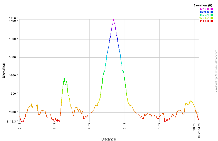
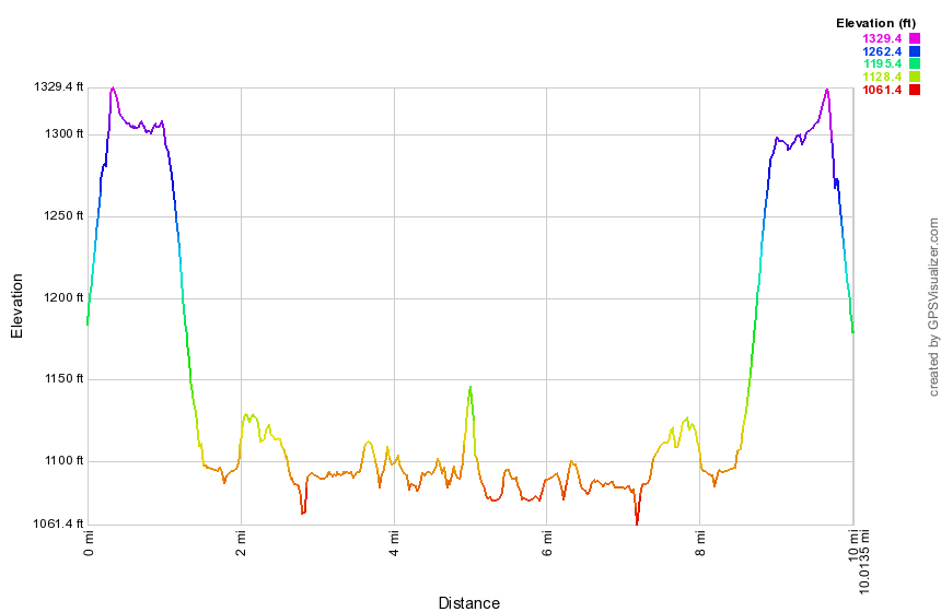 (The image at the left shows the profile of the hike. Remember that all vertical profiles are relative!)
Finger Lakes Trail: Hoxie Gorge to Baker Schoolhouse Road
| Quick Look | ||||
|---|---|---|---|---|
| Difficulty | Round trip | Total climb | Internet Maps | |
| 12.2 mi | 1830 ft. | AllTrails | ||
 The Finger Lakes Trail is a primitive footpath that starts in Allegheny State Park on the New York - Pennsylvania border and extends 576.5 miles to end in the Catskill Park at the beginning of the Table Peekamoose Trail off the Phoenicia East Branch Trail near the Denning trailhead. There are other side trails which increase the length of the trail system. Four hundred miles of this trail is also part of the Scenic North Country Trail. The Finer Lakes Trail Conference celebrated its 50th Anniversary on June 2, 2012. To commemorate the occasion the Conference set up a series of hikes that would cover the entire length of the trail. Hikes varied in length and difficulty from 4 to 14 miles. The Trail Conference continues to improve the trails and to move sections from roads to trails.
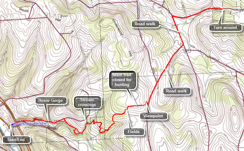
This hike is best done with a car spot since it is 6.25 miles one way for a total of 12.5 miles. The route described here is out and back with a little variation thrown in! Take Route 11 north from Marathon for about 8 miles toward Cortland. Watch for Hoxie Gorge Road on the right and turn onto this road. Just after the turn is a turn around where you should NOT park. Park on the shoulder just past the turn around. Just above you is the Hoxie Gorge Bridge on I81. Walk under the bridge on Hoxie Gorge Road. After a short walk, the road splits and you should stay to the left on Hoxie Gorge Road which is a dead end. A little farther along the road enters part of the gorge as the walls of the gorge rise on either side of the road. The road apparently is frequently washed out when this small stream swells when it rains. There are several areas which show considerable damage to the road. The road begins to gain some elevation and at about .9 miles the Finger Lakes Trail leaves the road to the right and begins to parallel the stream. SUNY Cortland has a "campus" on this road where they do environmental studies and their trail is marked with yellow markers. They also have number on the markers which must correspond to the types of trees and bushes. The Finger Lakes Trail continues to follow the stream as it drops down to the stream and then veers away from it. At around 1.4 miles the trail comes to a spot where a bridge crosses one stream and water pours out of a culvert beneath it in a sort of waterfall. From this point on the trail follows the Cortland trail for a while and crosses several small tributaries. There is a good amount of walking up and down especially when crossing these small streams. The forest begins to transition from evergreens to hardwoods as the trail heads generally east and northeast. At 2.6 miles you will start walking through some brush and weeds on the edge of a field and come out on a woods road.Continue to walk north a little then northeast and then turn almost due east when you come to the edge of a corn field. As you walk along the south edge of the field you will come to a spot where the trail makes a 90 degree turn to the left at about 3.3 miles. A sign explains that the trail is closed at this point for hunting during certain times. To take the hunting bypass do NOT turn left but continue along the fields and out to Stone Road. As you walk toward the road you may find a nice viewpoint over the corn fields and surrounding countryside. Turn left and head northeast on Stone Road for about .4 miles where the name changes to Atkins Road and Underwood Hill Road goes off to the left. Continue to walk another .75 miles mostly downhill to the McGraw Marathon Road. Turn left to head north passing several small farms on the way. It is .5 miles to our a right turn onto Baker Schoolhouse Road. After .9 miles, the Finger Lakes Trail cuts off the road to the left which marks the end of this section of the trail. If you have a car parked here, you have finished your hike. If your only car is back on Hoxie Bridge Road, retrace your route back to where you are parked. When you get to the yellow marked Cortland trails, you may simply follow them out to the road. This is a nice alternative and the trails are a little better maintained than the Finger Lakes Trail. You will break out onto Hoxie Gorge Road just above where you entered the woods. Walk downhill and through the gorge on the road to get back to your car.
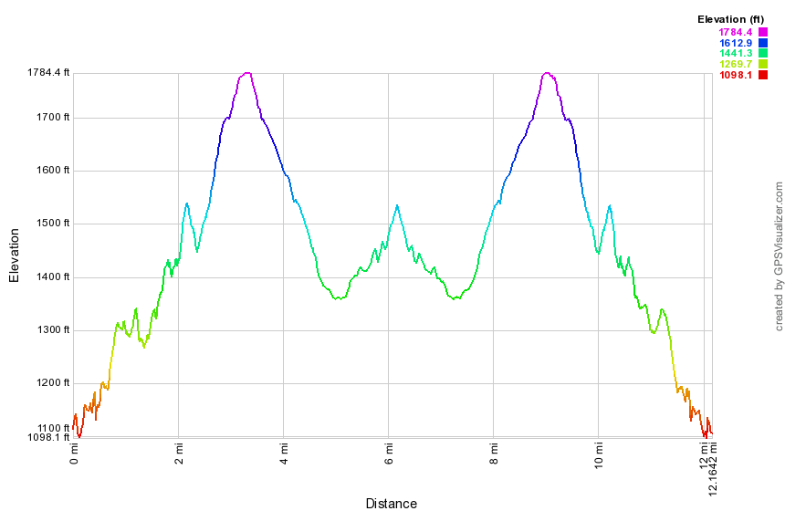 (The image at the left shows the profile of the hike. Remember that all vertical profiles are relative!)
Finger Lakes Trail: Apex Bridge to Fletcher Road
| Quick Look | ||||
|---|---|---|---|---|
| Difficulty | Round trip | Total climb | Internet Maps | |
| 10.3 mi. | 1350 ft. | AllTrails | ||
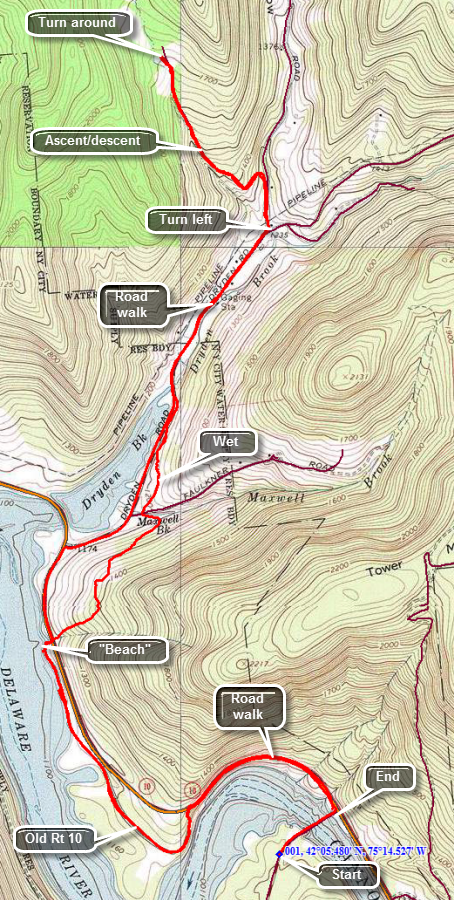 The Finger Lakes Trail is a primitive footpath that starts in Allegheny State Park on the New York - Pennsylvania border and extends 576.5 miles to end in the Catskill Park at the beginning of the Table Peekamoose Trail off the Phoenicia East Branch Trail near the Denning trailhead. There are other side trails which increase the length of the trail system. Four hundred miles of this trail is also part of the Scenic North Country Trail. The Finer Lakes Trail Conference celebrated its 50th Anniversary on June 2, 2012. To commemorate the occasion the Conference set up a series of hikes that would cover the entire length of the trail. Hikes varied in length and difficulty from 4 to 14 miles. The last section is the one described here and is mostly a road walk from The parking area on Black Bear Road (Wild Meadow Road) near Round Pond to the eastern terminus of the trail 1.2 miles from the Denning trailhead.
This hike works best with a car spot since the round trip is over 10 miles one way! The hike described here is out and back. Depending on where you are coming from there are a number of ways to get to Fletcher Road where you will park one car. Perhaps the best way to get there is to take the Cadosia exit from State Route 17 and go north on Route 268 to Route 10. Where Route 268 meets Route 10 is the beginning of the hike where you will park the one car in the lot at the end of the bridge. Drive south on Route 10 about 2 miles and turn right on Dryden Road. Drive north on Dryden Road and turn left after 1.5 miles on Finch Hollow Road. Turn left on Fletcher Road which is a gravel road that turns to a woods road with enough clearance for most cars. Park near the end of the road. When you get back to the Apex Bridge and are parked in the lot, walk across the bridge to when the Finger Lakes Trail meets the road on the left. Turn around to start your hike by walking back across the bridge and through the parking lot to the eastern shoulder of Route 10. Walk on the inside of the guardrail for .75 miles when the Finger Lakes Trail will descend the left bank. At the bottom turn right on Old Route 10 and walk a little more than a mile where the trail turns right into the woos. At this point you may first want to walk straight ahead to the shore of the reservoir. You can see where Old Route 10 simply enters the reservoir. Back on the trail hike along the reservoir with some additional viewing points and then ascend the bank to Route 10. Cross the road and begin to climb for about .25 miles gaining around 200 feet. After that you will descend and cross Faulkner Road at 3.1 miles. Continue across the road on the trail and follow it through some wet areas until it eventually meets Dryden Road at about 3.7 miles. Turn right on the road and walk to a Y. Turn left on Finch Hollow Road and walk short distance before turning left on Fletcher Road. This gravel road now begins an ascent and eventfully turns into a woods road in good condition. You will pass only one house on the way. A stream flows on the left side of the road. Walk about .75 miles on Fletcher Road gaining over 400 feet until you emerge in an open area where you may have parked another car. The Finger Lakes Trail goes straight ahead and into the woods. This is your turn around point if you do not have another car.
To return you may simply reverse your route. You may also vary your return trip slightly by walking all the way down Dryden Road to Route 10. The distance is only .65 miles. Turn left on Route 10 and walk back to your car at the Apex Bridge. You may also walk about .35 miles on Route 10 and then turn right onto the trail to follow it along the reservoir again. I like this option as the walking is almost as easy as on the road and is much more scenic. Near the end of the trip you will have to walk the last .75 miles on Route 10.
 (The image at the left shows the profile of the hike. Remember that all vertical profiles are relative!)
Finger Lakes Trail: Otselic SF to Grover Brown Road
| Quick Look | ||||
|---|---|---|---|---|
| Difficulty | Round trip | Total climb | Internet Maps | |
| 12.6 mi | 1200 ft. | AllTrails | ||
 The Finger Lakes Trail is a primitive footpath that starts in Allegheny State Park on the New York - Pennsylvania border and extends 576.5 miles to end in the Catskill Park at the beginning of the Table Peekamoose Trail off the Phoenicia East Branch Trail near the Denning trailhead. There are other side trails which increase the length of the trail system. Four hundred miles of this trail is also part of the Scenic North Country Trail. The Finer Lakes Trail Conference celebrated its 50th Anniversary on June 2, 2012. To commemorate the occasion the Conference set up a series of hikes that would cover the entire length of the trail. Hikes varied in length and difficulty from 4 to 14 miles. The Trail Conference continues to improve the trails and to move sections from roads to trails.
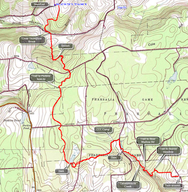
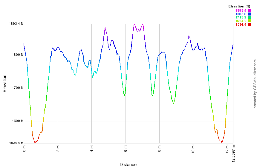
This hike is best done with a car spot since it is 6.9 miles one way for a total of 13.8 miles. The route described here is out and back with a little variation thrown in! Take the exit for Whitney Point off of I-81. Follow Route 26 north for about 29 miles passing through South Otselic. Watch for Stage Road on your right shortly after passing through town. Drive to the end of the road and turn left on Will Warner Road. The road is dirt and gravel and not maintained during the winter after a certain point. Drive 1 mile on Warner Road and you will find an access road to Otselic SF on the right. Park at the end of the road at the intersection out of the way of "traffic". Begin your hike by walking east on Warner Road for about .1 miles. Turn right into the forest and almost immediately run into some wet spots on the trail. Over the next .7 miles the trail drops over 300 feet to Thompson Brook before ascending slightly to meet Stage Road. You will have to walk back up this hill at the end of you hike if you do not have a car shuttle. As we were losing elevation I thought about the return trip knowing that I would be tired. I stopped at Thompson Brook to take a few pictures before walking up to Stage Road. Once on Stage Road we turn left and walk a few hundred feet up the road to where the trail crosses the ditch and heads into a field. Hug the left edge of the field but do not be surprised if you find only one or two blazes. Over the next 1.1 miles the trail continues to ascend but dips several times to cross streams. Most of the streams do not have bridges and several crossing could be tricky in highwater. Watch for small waterfalls along the way during periods of high water.Crossed Church Road at about 2 miles at which point the trail levels some and the surface becomes more even. Pass a trail register and then at around 2.5 miles we pass a blue blazed trail on the right to the Perkins Pond Lean-to. The trail to the lean-to is .4 miles. At 3.3 miles cross Johnson Street. The trail has gained a little elevation and you will be hiking at about 2040 feet before descending to the dam at the south end of Jackson Pond. Walk to the spillway, turn right and descend through a small filed or clearing to pick up the blazes of the Finger Lakes Trail. Follow the blazes as they cross the access road and lead you to John Smith Road. Cross the road and continue into the forest where the trail now turns east instead of south and levels off before starting to descend again. Along the way at about 5.5 miles you will pass through and old CCC camp. (Your mileage may vary since I made some errors along the way. The mileages on the Finger Lakes Trail maps seem pretty accurate.) In just 80 years the forest has reclaimed most of the buildings. At 5.7 miles you will hit Elmer Jackson Road where you should turn right. Walk down the road following the blazes until you approach a small pond with a kiosk for the Pharsalia Wildlife Management Area. Turned left and walk over the dam at the end of the pond. Note the interesting spillway underneath the bridge. Continue across the dam and take a right to follow Canasawacta Creek for the next mile as the trail drops to the creek and then ascends several times until pulling away from the creek and starting a steep ascent at 6.7 miles. At about 6.4 miles you will pass a blue trail that heads out to Bear Wallow Road where there is parking and shortly after another blue blazed trail that leads to a beaver meadow. Continue on the main trail which skirts the DEC boundary line with private property and follows a woods road. At just under 7.5 miles, you will be at the point where the trail meets Grover Brown Road. There is enough room to park one or two cars here. The road is dirt and gravel but is no worse than some of her other roads in the area. It is less than a mile to Route 23 in North Pharsalia. If you have a car parked here, you can relax on the drive back to Otselic SF. If you have only one car, turn around and follow your route 7 miles back to your car!
 (The image at the left shows the profile of the hike. Remember that all vertical profiles are relative!)
Finger Lakes Trail: Grover Brown Rd to Berry Hill
| Quick Look | ||||
|---|---|---|---|---|
| Difficulty | Round trip | Total climb | Internet Maps | |
| 12.4 mi | 1520 ft. | AllTrails | ||
 The Finger Lakes Trail is a primitive footpath that starts in Allegheny State Park on the New York - Pennsylvania border and extends 576.5 miles to end in the Catskill Park at the beginning of the Table Peekamoose Trail off the Phoenicia East Branch Trail near the Denning trailhead. There are other side trails which increase the length of the trail system. Four hundred miles of this trail is also part of the Scenic North Country Trail. The Finer Lakes Trail Conference celebrated its 50th Anniversary on June 2, 2012. To commemorate the occasion the Conference set up a series of hikes that would cover the entire length of the trail. Hikes varied in length and difficulty from 4 to 14 miles. The Trail Conference continues to improve the trails and to move sections from roads to trails.
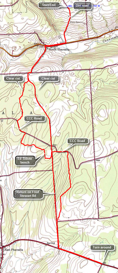
This hike is best done with a car spot since it is 6.8 miles one way for a total of 13.6 miles. The route described here is out and back with a little variation thrown in! By returning on roads the distance back is cut by 1.3 miles. Take County Route 23 west from Norwich for about 11.5 miles toward North Pharsalia. Watch for Grover Brown Road on the right which may not be marked. If you come to the intersection of Route 23 with FreStewart Road (right) and One Eye Street (right), you have gone too far. Drive up paved Grover Brown Road passing the "Seasonal Maintenance" sign where a gravel/dirt surface starts. The surface is good without too many dips or holes but you may not want to try it without an all-wheel drive vehicle. At about .6 miles from Route 23 the Finger Lakes Trail meets the road. Drive a little farther, turn around and park where the trail meets the road. To begin the hike walk .6 miles down Grover Brown Road to Route 23. Turn right and walk .7 miles along the shoulder to Fred Stewart Road on the left. This road heads south to Route 10 which is your destination. The Finger Lakes Trail, however, leaves the road several times to enter the forest. Walk south on Fred Stewart Road for .6 miles, turn right on Center Road and then make a quick left back onto Fred Stewart Road. The road at this point has a gravel surface and a "seasonal maintenance" sign but is in good shape. After walking another .1 miles, turn right into the forest. The trail surface is pretty flat with only a few rocks. In about .8 miles you will meet an old CCC road. After a short walk you will enter a clear cut area not mentioned on the map! The trail may be overgrown with prickers which flourish in the sunlight. The trail can be hard to follow in many places and there are few blazes to guide the way. The trip through the clear cut is actually short and after that you will enter an evergreen forest. When you meet the CCC road, turn left and hike along the road for .3 miles to the point where the Finger Lakes Trail leaves the road on the right. The trail now is wider and cushioned by pine needles. You will come to a stone wall where the trail turns right and just after this, at 3.6 miles, is a stone bench dedicated to Ed Sidote. Mr. Sidote chose this place. He is #3 on the FLT End-to-End list and has served the Finger Lakes Trail Conference as president and in many other capacities. Just after the bench is a stone foundation on the right. Cross the road and continue downhill to the CCC road where you will turn right. After .3 miles on the road, the trail again enters the woods on the right. Over the next 1.3 miles the trail ascends and descends a small hill staying parallel to the road until meeting it again at the intersection with Hoag-Childs Road. At this point the rest of the hike is a road walk to North Tower Road. Fred Stewart Road is now paved and the walk is downhill for .5 miles to Route 10. You will pass Dave Markham's machine shop where water is available. At Route 10 we turn left and start to walk east to North Tower Road. Route 10 is busy and has no paved shoulders for walking. It does have good sight lines so that you can get out of the way when cars or trucks are coming. The walk is mostly up hill for .8 miles to the intersection with Tower Road. If you have parked another car at the Berry Hill Fire Tower, Walk south on Tower Road for .3 miles to the access road to the fire tower. If you are by yourself, you must turn around and retrace your route back to your car. To save some distance, you can hike back all the way on Fred Stewart Road. The walk is pleasant as the road is mostly dirt and gravel and is very lightly traveled. This saves about 1.3 miles! The hike back on Route 10 was quick and we made good time back to the road intersection. I decided that we would walk back all the way on the road since it was easier to walk and had a dirt and gravel surface. It seemed that this route would also save some distance as it was absolutely straight. As we hiked the insects returned but were manageable. I kept Sheila on her leash as we had met several trucks along the way. In 1.2 miles we were at the point where the trail crossed the road and we continued north crossing the CCC Road. In another 1.3 miles we were at the point where we had first entered the woods. Along the way we passed another area where the trees were "disturbed". I stopped to take some pictures but could not decided whether this was a clear cut area or was caused by some other "disaster". We walked back out to Center Road and turned right and then left to follow Fred Stewart Road back to Route 23. From here we simply retraced our steps to Grover Brown road and then to the car. The final uphill on Grover Brown Road was easier than I thought it might be. We were back at the car at 2:10 PM having covered 12.4 miles in 4.5 hours. The vertical gain was over 1500 feet but most of this was on the roads. The trip out on the trail was 6.8 miles while the return journey was 5.5 miles saving 1.3 miles and a little over 20 minutes as I had hoped.
 (The image at the left shows the profile of the hike. Remember that all vertical profiles are relative!)