
| Pick a Scary 19 Peak: |
Cotton Hill
Cotton Hill is located in the Dutch Settlement State Forest. It can be accessed from a very easy location on Treadlemire Road. The route that I suggest is from the Village of Middleburgh via the Long Path. The Long Path in Middleburgh can be accessed from the dead end MT Path by parking in the cul-de-sac. This route follows the Long Path thru Cotton State Forest into the Dutch Settlement State Forest. Spotting a vehicle at Treadlemire Road and starting from MT Path would make for a great traverse.
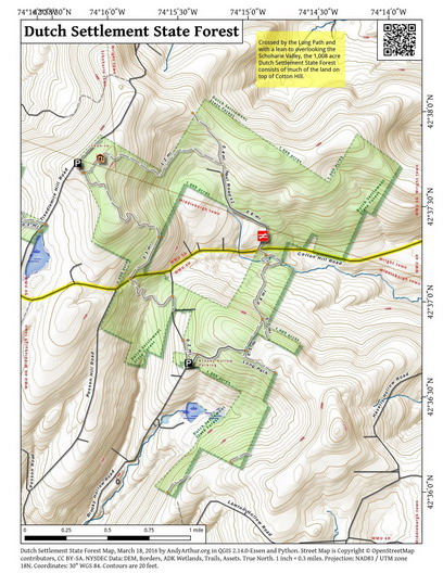
Clicking on the map below will allow you to download a full page, printable PDF map. (Courtesy of Andy Arthur)
| Quick Look | ||||
|---|---|---|---|---|
| Difficulty | Round trip | Total climb | Internet Map | Parking |
| .6 mi. | 120 ft. | AllTrails | N42.6292 W74.2704 | |
| 6.1 mi. | 2310 ft. | AllTrails | N42.6292 W74.2704 (Treadlemire) N42.5971 W74.3259 (MT Path) | |
| 11.5 mi. | 3165 ft. | AllTrails | N42.5971 W74.3259 (MT Path) | |
The easiest possible approach to Cotton Hill is from the Long Path off Treadlemire Road. From the village of Middleburgh, drive southeast on Route 145. Turn left on Cotton Hill Road just before the cemetery. Stay on Cotton Hill Road for 3.2 miles. Just after Cotton Hill makes a sharp right, turn left on Treadlemire Road and drive .9 miles watching for the point where the Long Path crosses the road. Park on the side of the road out of the way of traffic. Get on the Long Path and follow it as it starts uphill along the shoulder of Cotton Hill. After a short walk of about a quarter mile turn right off the trail and start to bushwhack Cotton Hill. The summit is relatively flat so look for the highest point you can find. Return to your car the way you came.
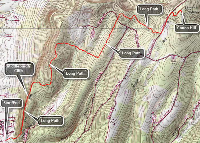
A more interesting approach to Cotton Hill is to park one car on Treadlemire Road and drive back in another car to park on MT Path in Middleburgh. From the village of Middleburgh, drive southeast on Route 145 in two cars. Turn left on Cotton Hill Road just before the cemetery. Stay on Cotton Hill Road for 3.2 miles. Just after Cotton Hill makes a sharp right, turn left on Treadlemire Road and drive .9 miles watching for the point where the Long Path crosses the road. Park one car on the side of the road out of the way of traffic. Return to Middleburgh the way you came. Turn right on Route 145 and drive .6 miles to Straub Lane. Turn right on Straub Lane and continue straight ahead on MT Path. Park in the cul-de-sac at the end of MT Path. (As an alternative, park at the elementary school across the street from Straub Lane.) Look for the aqua blazes at the end of MT Path which ascend the Middleburgh Cliffs. This is a rugged but rewarding climb. The reward is a view across the valley to Vroman's Nose and the other hills. Continued on the Long Path as it heads away from the cliffs at 1.3 miles. At 2.4 miles the Long Path turns east and dips down from the cliffs heading southeast. At 3.2 miles it turns 90 degrees heading northeast in a straight line for .85 miles. The Long path makes another 90 degree turn and heads southeast for .9 miles to Treadlemire Road. Turn left on the road and walk .4 miles to where the Log Path again turns into the woods. Make the right urn and follow the Long Path as it starts uphill along the shoulder of Cotton Hill. After a short walk of about a quarter mile turn right off the trail and start to bushwhack Cotton Hill. The summit is relatively flat so look for the highest point you can find. Return to the car you parked on Treadlemire Road the way you came.
A more challenging approach to Cotton Hill is to park on MT Path in Middleburgh and hike the Long Path to Cotton Hill and back! This requires only one car but does require a good deal of stamina. From the village of Middleburgh, drive southeast on Route 145 in two cars. Turn left on Cotton Hill Road just before the cemetery. Stay on Cotton Hill Road for 3.2 miles. Just after Cotton Hill makes a sharp right, turn left on Treadlemire Road and drive .9 miles watching for the point where the Long Path crosses the road. Park one car on the side of the road out of the way of traffic. Return to Middleburgh the way you came. Turn right on Route 145 and drive .6 miles to Straub Lane. Turn right on Straub Lane and continue straight ahead on MT Path. Park in the cul-de-sac at the end of MT Path. (As an alternative, park at the elementary school across the street from Straub Lane.) Look for the aqua blazes at the end of MT Path which ascend the Middleburgh Cliffs. This is a rugged but rewarding climb. The reward is a view across the valley to Vroman's Nose and the other hills. Continued on the Long Path as it heads away from the cliffs at 1.3 miles. At 2.4 miles the Long Path turns east and dips down from the cliffs heading southeast. At 3.2 miles it turns 90 degrees heading northeast in a straight line for .85 miles. The Long path makes another 90 degree turn and heads southeast for .9 miles to Treadlemire Road. Turn left on the road and walk .4 miles to where the Log Path again turns into the woods. Make the right urn and follow the Long Path as it starts uphill along the shoulder of Cotton Hill. After a short walk of about a quarter mile turn right off the trail and start to bushwhack Cotton Hill. The summit is relatively flat so look for the highest point you can find. Return to the car you parked in Middleburgh the way you came. (You can also stay on Treadlemire Road, walk to Cotton Hill Road, and return on Route 145. This saves a mile, is a scenic walk and is all downhill or flat!)
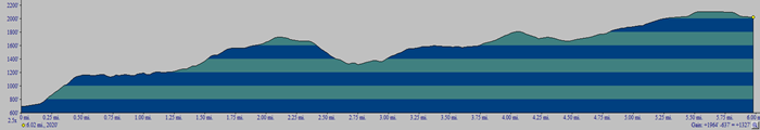 (The image shows the profile of the hike. Remember that all vertical profiles are relative!)