
| Pick a Scary 19 Peak: |
NE Fulton Hill
NE Fulton Hill is located in the Mallet Pond State Forest. NE Fulton Hill can be accessed from DEC parking area at Mallet Pond. For a more challenging approach it can be accessed from the DEC parking areas on Sawyer Hollow Road.
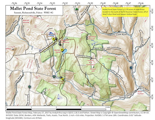
Clicking on the map below will allow you to download a full page, printable PDF map. (Courtesy of Andy Arthur)
| Quick Look - from intersection Rossman Valley Road and Rossman Fly Road | ||||
|---|---|---|---|---|
| Difficulty | Round trip | Total climb | Internet Map | Parking |
| 4.5 mi. | 740 ft. | AllTrails | N42.5890 W74.5331 | |
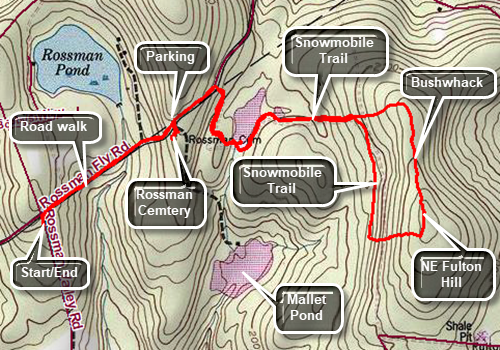
Drive to Summit, NY and head east on Sawyer Hollow Road (Route 20). Drive 3.1 miles to Rossman Valley Road. Turn left and head north for 1.2 miles to the intersection with Rossman Fly Road. Park on the side of the road to begin your hike. (When the road are in good shape, you can turn right in Rossman Fly Road and drive half a mile to park in the DEC lot.) Start your hike by walking back up the road to Rossman Fly Road. Turn right and walk down a steep hill on Rossman Fly Road toward Mallet Pond State Forest. At the bottom of the hill, start to walk back uphill. Continue passed the first road on the right near the state forest sign. Turn right on the next road at .8 miles and walk downhill to a small pond. You may be able to walk across the dam to the other side depending on the water level. If this is not possible cross where the water is narrowest. At the other end of the dam and pick up the snowmobile trail to an even smaller pond. Continue on the snowmobile trail as is starts slightly uphill through a pine plantation to 1.65 miles where the trail turns south. Start off the trail by continuing to head east and up to the ridge. At the top of the ridge, around 1.85 miles, turn 90 degrees and start heading due south staying on the highest part of the ridge. Watch for a series of beautiful stone walls that run throughout the area. Try to follow the highest part of the ridge without dipping down and you may come upon a woods road which heads for the highest point. When the road gives out continue south and find the highest point on the hill. Turn west and start to work your way down what looks to be very steep ground on the map. In reality there are a few modest ledges that are easy to ascend. In about .2 miles you will be on the snowmobile trail. Turned right heading north until you are at the point where you left the snowmobile trail. On the way back, you can visit the Rossman Cemetery by turning left off the main road onto the road that goes down to Mallet Pond near the state forest sign. Immediately after turning look to your right to find the small cemetery. Walk in that direction and you will see a stone wall was surrounding perhaps 8 markers. There is a lot of history in these places but many are in disrepair. When you are done, walk back out to the main road and follow it west to your car.
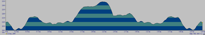 (The image shows the profile of the hike. Remember that all vertical profiles are relative!)