
| Pick a Scary 19 Peak: |
Rossman Hill NW
Rossman Hill/NW is located in the Burnt Rossman Hills State Forest. It can be accessed from many DEC parking areas including Looking Glass Pond parking area, Western West Kill Road, Eastern West Kill Road, North Road, Sawyer Hollow Road, Eminence Road Parking, Yankee Street, Rossman Hill Road, and Morey Road. The recommended route id from the parking area on Sawyer Hollow Road.
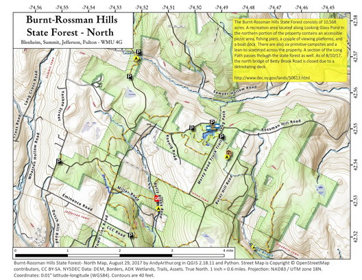
Clicking on the map below will allow you to download a full page, printable PDF map. (Courtesy of Andy Arthur)
| Quick Look - from Sawyer Hollow Road | ||||
|---|---|---|---|---|
| Difficulty | Round trip | Total climb | Internet Map | Parking |
| 4.8 mi. | 1020 ft. | AllTrails | N42.5592 W74.4868 | |
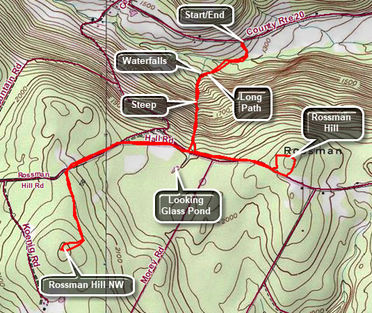
Head north on Route 30 through Margaretville, Roxbury and Grand Gorge. After passing through North Blenheim, watch for West Fulton Road on the left. Turn left on West Fulton Road and drive about 3 miles to the four corners in West Fulton. Turn left on Sawyer Hollow Road and drive 1.25 miles to the point where the Long Path turns off the road to the left. Park off the shoulder of the road where you can. If there is no place to park, you can drive back to West Fulton and park there. The aqua-blazed Long Path descends through a field to Panther Creek. The grass is usually mowed to form a wide path down to the creek. Near the creek the trail turns to the right and follows the stream for about .1 miles where there is a bridge. The bridge is old but sturdy and built high enough above the creek that it has withstood many storms. The Long Path now passes through hardwood forest and soon the trail begins to climb and then climb steeply. The trail runs close to a small creek. Over the next .7 miles the trail gains 710 feet with the trail grade average over 17%. When there is a good volume of water in the creek, you can hear that the water flowing over the rocks. If you walk over to the edge of the stream, you can see several cascades and waterfalls. Continued walking up the trail and you will see many of these waterfalls with each one seeming to be nicer than the previous. Any description you read does not do these falls justice as you must seem them yourself. Near the top of the climb is the last water fall and you should notice a stone structure in the streambed. A waterwheel was mounted here to power a gristmill. As you continue on the Long Path, it intersects Rossman Hill Road at .75 miles. On the other side of the road the trail may be wet in places and there is an indistinct trail that leads to the shore of Looking Glass Pond. Turn right on Rossman Hill Road and walk .65 miles to the west along the road. Look for a woods road on the left or simply turn left and start to bushwhack about .45 miles to the top of Rossman Hill NW. Return to Rossman Hill Road and head east. At this point, you could return to your car. Continue walking along Rossman Hill Road for about 1.2 miles when Rossman Hill will be on your left. Turn left heading north into the woods to bushwhack Rossman Hill. To return from the summit, retrace your steps or follow a woods road back to Rossman Hill Road. Turn right heading east to the junction with the Long Path. Turn right and enjoy the downhill to your car.
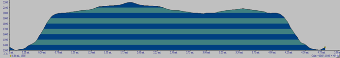 (The image shows the profile of the hike. Remember that all vertical profiles are relative!)