
Long Path
Besides the thirty-five 3500 foot peaks in the Catskills, there are many other smaller mountains to climb. In addition, there are hundreds of miles of trails to hike. There are also MANY other places to hike also. I have divided the Trails section into list of All Trails, the Catskills, the Shawangunks, Bear Mt/Harriman, East Hudson, West Hudson, New Jersey, Finger Lakes Trail, Long Path and Other Trails. The All Trails list includes over 600 different trails and may load slowly on your computer. The "divided" lists should load more quickly.
You can view all the sections of the Long Path I have hiked here from North to South. Clicking on ![]() will bring up an index of trails. Clicking on
will bring up an index of trails. Clicking on ![]() will return you to the top of the page. Click HERE for a map of these sections.
will return you to the top of the page. Click HERE for a map of these sections.
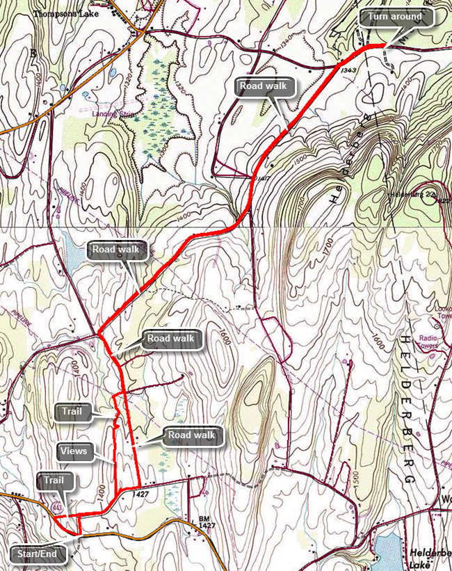
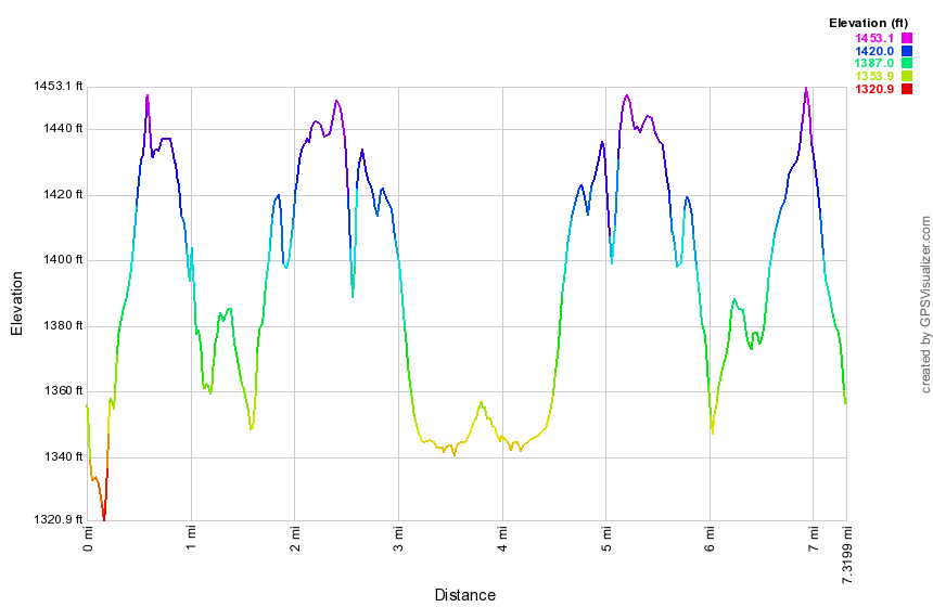
Ryan Road to Old Stage Road
| Quick Look | |||
|---|---|---|---|
| Difficulty | Round trip | Total climb | Internet Maps |
| 5.5 mi. | 480 ft. | AllTrails | |
 (The image at the left shows the profile of the hike. Remember that all vertical profiles are relative!)
Beaver Dam Road to Ryan Road
| Quick Look | |||
|---|---|---|---|
| Difficulty | Round trip | Total climb | Internet Maps |
| 8.6 mi. | 1615 ft. | AllTrails | |
 (The image at the left shows the profile of the hike. Remember that all vertical profiles are
relative!)
(The image at the left shows the profile of the hike. Remember that all vertical profiles are
relative!)
Stage Road to Beaver Dam Road
| Quick Look | |||
|---|---|---|---|
| Difficulty | Round trip | Total climb | Internet Maps |
| 7.3 mi. | 640 ft. | AllTrails | |
 (The image at the left shows the profile of the hike. Remember that all vertical profiles are relative!)
Willsie Road to East Berne
| Quick Look | |||
|---|---|---|---|
| Difficulty | Round trip | Total climb | Internet Maps |
| 9.6 mi. | 1180 ft. | AllTrails | |
 (The image at the left shows the profile of the hike. Remember that all vertical profiles are
relative!)
(The image at the left shows the profile of the hike. Remember that all vertical profiles are
relative!)
Gifford Hollow to Willsie Road
| Quick Look | |||
|---|---|---|---|
| Difficulty | Round trip | Total climb | Internet Maps |
| 6.8 mi. | 830 ft. | AllTrails | |
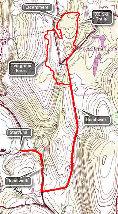
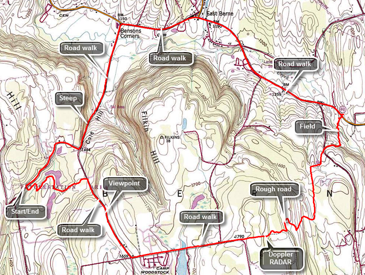
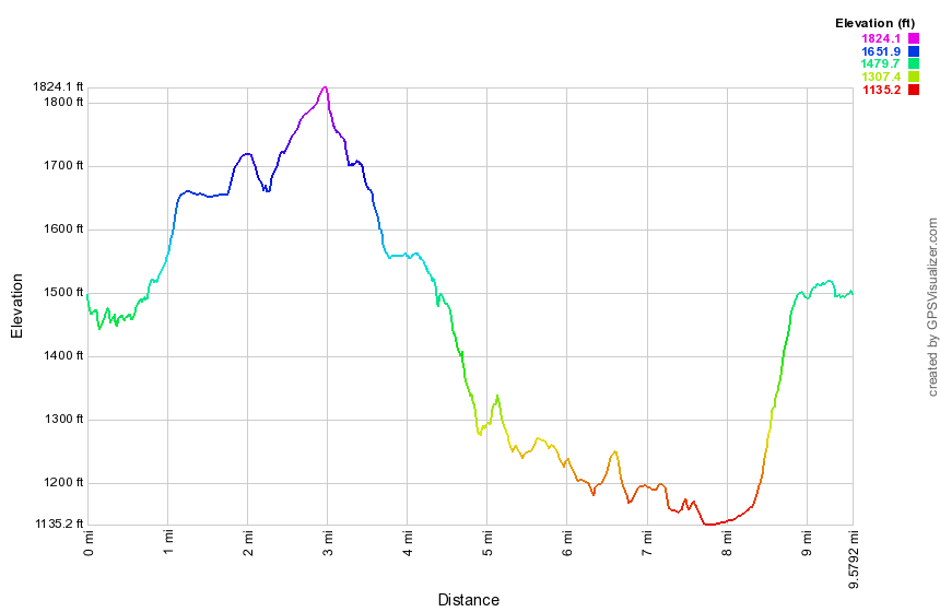
Follow Route 30 into Middleburgh and turn right to head east on Route 145 to Cotton Hill Road just outside of town. Turn left on Cotton Hill Road and drive 8.3 miles to Route 443, the Helderburg Trail. Make a left and drive 1.3 miles to Switz Kill Road (CR-1). Turn right and follow it 4.0 miles to Gifford Hollow Road on the right. Park on the shoulder of the road at the intersection. Start by walking south on Switz Kill Road for about .7 miles. Turn left onto Willsie Road which is flat momentarily and then begins to climb gently up a hill. As you climb up the hill and reach the top at 1.8 miles there are nice views across Partridge Run to the Catskills. Continue to walk along the road. At 2.1 miles the blazes on a telephone pole indicate a left turn. There seems to be a woods road on the left but just passed this the trail turned into the woods. Walk uphill and then down through some stands of pine and spruce with hardwoods between them. There are several stone walls to cross. At 3.1 miles cross Irish Hill Road where there is a shale pit and room to park a few cars. The trail ascends briefly and the aqua blazes share the trees with state cross country ski trail markers. As you walk along the trail pay attention to the blazes as there are numerous woods roads, trails and ski trails that cross the path. In general, the aqua blazes are good enough to guide your course. Begin to walk along an escarpment at about 3.3 miles. Cross several more stone walls as you reach the highest point on the hike at 3.75 miles. Here it looks as if the trail continues straight ahead but the blazes lead to the right. Start to descend through some pines until you intersected Woolsie Road at 4.2 miles. Turn right on Willsie Road to hike back to the car.
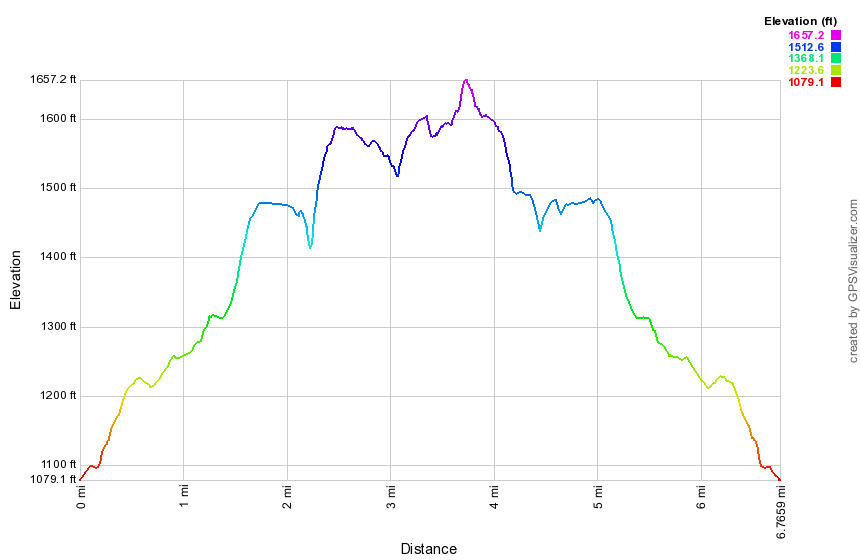 (The image shows the profile of the hike. Remember that all vertical profiles are relative!)
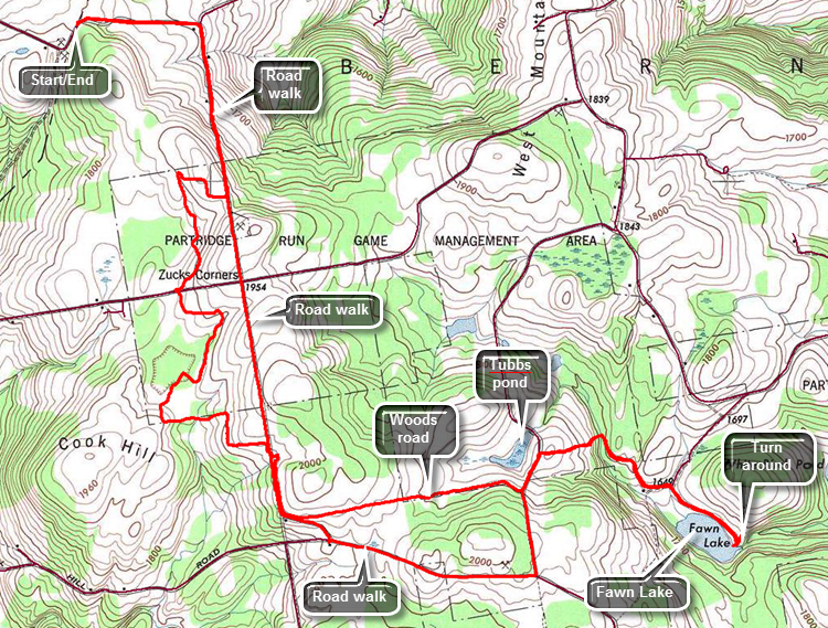
Fawn Lake to Gifford Hollow
| Quick Look | |||
|---|---|---|---|
| Difficulty | Round trip | Total climb | Internet Maps |
| 9.2 mi. | 1460 ft. | AllTrails | |
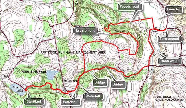
Follow Route 30 into Middleburgh and turn right to head east on Route 145 to Huntersland Road just out side of town. Turn left on Huntersland Road and drive 5.5 miles. Make a left on High Point Road. When High Point Road meets Sickle Hill Road after 3.8 miles, turn right and follow Sickle Hill Road for 1.6 miles to Fawn Lake Road. Turn right on Fawn Lake Road and drive to the parking lot at the end of the road near Fawn Lake. Begin the hike by following the trail as it leaves the upper end of the parking area on a snowmobile trail. After a slight ascent the trail begins to descend to a trail intersection at about .5 miles. Here a trail to the left branches off to White Birch Pond. Stay right on the Long Path and cross a stream on a bridge. At .8 miles the trail comes out to gravel Partridge Run Road. Turn right and walk down to Ravine Road at almost exactly one mile. The trail turns left and follows Ravine Road for a couple hundred feet before turning right again on Partridge Run Road. Continue on Partridge Run Road which is in pretty good shape but would require a high clearance vehicle to access. At 1.3 miles you may want to walk off the main trail to the right to inspect a waterfall on Partridge Run. At 1.6 miles Partridge Run Road turns to the right and descends to cross a bridge over the stream. The Long Path heads slightly left and comes to an open area. Continue passed a gate on the road and then a small pond on the right. A snowmobile trail comes in from the left. Continued ahead to a fork in the trail and bear left. The trail begins to ascend to an escarpment above Partridge Run. Unfortunately there are no viewpoints along the trail. At 2.4 miles intersect another woods road and begin to follow it until the trail turns off the road. The blazes are very clear in this area. At one point a switchback takes you along a wall of rock and then to a higher level on the escarpment. At 3.9 miles begin a switchbacked descent to the Switz Kill Valley. At 4.4 miles start to follow a woods road that parallels the edge of a field. The trail breaks out into the last field on your descent and straight ahead is the Gifford Hollow lean-to. This lean-to was finished in 2012 as an Eagle Scout project. At 5.1 miles make a sharp right and walk along the edge of a field to Gifford Hollow Road at 5.3 miles. Make a left turn onto the road and hike out to Switz Kill Road at 5.5 miles. You may now turn around and retrace your steps or try another return route. Turn around and walk back on Gifford Hollow Road passing the point where the trail intersected the road. After .75 miles, there is a sign for the Partridge Run Wildlife Management Area. Look closely when you get to this sign as what is left of Partridge Run Road turns to the right here. As you walk it is clear that at some point the stream was high enough to wash out a large part of the road. You may want to walk down to the streambed to get a closer look at the work the stream has accomplished. At about 7 miles there is a sign that says "Bridge Closed Ahead". The bridge is intact but has seen better days. At 7.2 miles cross the bridge and continue on the road until another bridge at 7.7 miles. Walk up a little hill and you will be back at the point where you were earlier in the hike just below the waterfall. Continue to walk west on Partridge Run Road until at about 8 miles you can see another waterfall on the stream below. You may want to visit this one as it has an unusual conformation. There is a drop of about 8 feet over a solid rock wall. Water shoots out from two places that have worn more deeply than the rest of the rock. Climb the bank to the road and continue out to Ravine Road. From this point on simply follow your route from earlier back to the parking area at Fawn Lake. where we had just turned around and see how e felt at that point.
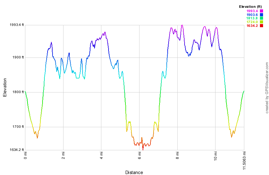
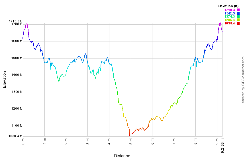 (The image at the left shows the profile of the hike. Remember that all vertical profiles are relative!)
Albany County Line to Fawn Lake
| Quick Look | |||
|---|---|---|---|
| Difficulty | Round trip | Total climb | Internet Maps |
| 11.5 mi. | 1550 ft. | AllTrails | |
Head north on Route 30 through Margaretville, Roxbury, Grand Gorge, North Blenheim and Middleburgh. Just over the Route 30 bridge in Middleburgh, turn right on Route 145 and follow it to the other side of town to Huntersland Road. Turn left on Huntersland Road and drive 2.7 miles and make a left on Lawton Hollow Road. After driving 3.9 miles on Lawton Hollow Road, pull over to the left side of the road where there is a shale pit and room for several cars. Just passed this spot on the right is a "Welcome to Albany County" sign. The first .5 miles of the hike is slightly downhill on Lawton Hollow Road to the intersection with Bradt Hollow Road. Walk south on Bradt Hollow Road for about .7 miles gaining about 260 feet in the process. There aren't many aqua blazes but watch for a brown and yellow sign for the Partridge Run Wildlife Management Area on the left side of the road. It has blazes that indicate a right turn onto a snowmobile trail. The trail is usually mowed but may be overgrown with grass and weeds. From this point on most of the trail follows snowmobile and Nordic ski trails and woods roads. The aqua blazes are very clear in most cases. At 2.1 miles cross High Point Road and begin walking through stands of Norway spruce and red pine. At about 2.7 miles there is a beaver pond and the trail parallels it for a short distance and then turns right shortly after that. The trail stays near the pond briefly and then turns away from it to the left. Begin an uphill walk which brings you to Bradt Hollow Road at 3.6 miles. Walk out onto the road and turn right and almost immediately left onto a gravel road. Take the next right into a snowmobile trail but watch carefully as the blazes are hidden. The snowmobile trail parallels the road for at least a quarter mile and then begins to swing east away from the road. Begin to follow an extremely straight woods road which seems to be the boundary between private and state land. Walk mostly downhill for about a mile to Beaver Road. Turn left on Beaver Road and walk downhill for about .2 miles where the trail turns right off the road at 5.1 miles. Continue downhill on a snowmobile trail that leads to Tubbs Pond which is not marked on all maps. Continue across the bridge just downstream from the dam. From the parking area, continue to walk on the access road to 5.8 miles then turn right on Fawn Lake Road. It is only about .4 miles to the end of the road at the Fawn Lake parking area. The road parallels the lake shore most of the way. The Long Path continues through the parking area to the left onto a snowmobile trail. This is the turnaround point for the hike and as always you may simply follow your route back to the car. Walking the back roads provides and interesting alternative. Retrace your route back to Tubbs Pond and back up to Beaver Road. Turn left on Beaver Road and continue passed the trail. Walk .3 miles out to Bradt Hollow Road and turn right on Bradt Hollow Road. Walk .9 miles to the intersection with Cook Hill Road. There was a small parking area here and a sign describing the wildlife management area. Follow Bradt Hollow Road to the right. The road is exceptionally straight and heads almost due north. At 9.9 miles cross High Point Road and at 10.3 miles you will be back at the point where you turned off the road onto the trail earlier in the day. It is just .7 miles back to Lawton Hollow Road. Turn left and walk the .5 miles back to the car.
 (The image shows the profile of the hike. Remember that all vertical profiles are relative!)
Treadlemire Road to Albany County Line
| Quick Look | |||
|---|---|---|---|
| Difficulty | Round trip | Total climb | Internet Maps |
| 10.8 mi. | 2363 ft. | AllTrails | |
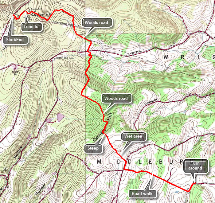
Head north on Route 30 through Margaretville, Roxbury, Grand Gorge, North Blenheim and Middleburgh. Just over the Route 30 bridge in Middleburgh, turn right on Route 145 and follow it to the other side of town. Turn left on Cotton Hill Road and after about 3 miles, make a left on Treadlemire Road. Drive just less than a mile to the parking area on the right. Walk out the back of the parking area on a woods road. After a very short distance, turn left and walk up a trail between two rocks with very interesting sedimentary layers. Within .3 miles walk up a steep but short hill and arrive at the Cotton Hill lean-to. Despite some trail descriptions there are no views from here. After the lean-to, start a descent on a nice combination of trail and woods roads. Watch the blazes carefully as there area numerous other paths and roads that cross the trail. At 1.2 miles you will reach a DEC access road which will lead out to Cotton Hill Road. The trail crosses the road and continues to descend briefly to a bridge across a stream. You will now have descended over 700 feet from the starting point and have covered about 2 miles. Head south and climb a woods road. Near the top of the hill at about 2.4 miles the trail turns off the road to the right and begins an even steeper climb. It soon levels off and then begins to descend. At 2.7 miles the woods road makes a sharp left before breaking out into an open area. Watch for the PortaJon on the left sitting out in the middle of nowhere! Even through this area the blazes are clear. Continue to walk on the woods road along the western side of Canady Hill until about 3.5 miles where the trail turns sharply left and begins a steep ascent. There may be active logging in the area. The trail "climbs over the hill" but never crosses over the summit. You will soon crest the hill and start down the other side. Some trail description talk about a "spectacular view" but there is no view. You are on private land at this point so be sure to only stay on the trail. The trail levels out and for a short distance the area is "very wet". Find some high ground and watch the aqua blazes and you will soon be at Canady Hill Road. Turn right on Canady Hill Road and then made a quick left on Lawton Hollow Road. The road immediately descends and then starts to ascend again. Some trail descriptions mentioned "views" to both the north and south but there are no views. At 5.4 miles there is a gravel pit on the left with a few spaces for parking and just passed this a sign for the Albany County Line. Turn around and retrace your route back to the car. The ascent up Cotton Hill at the end may be steep at times but the steep parts are short!
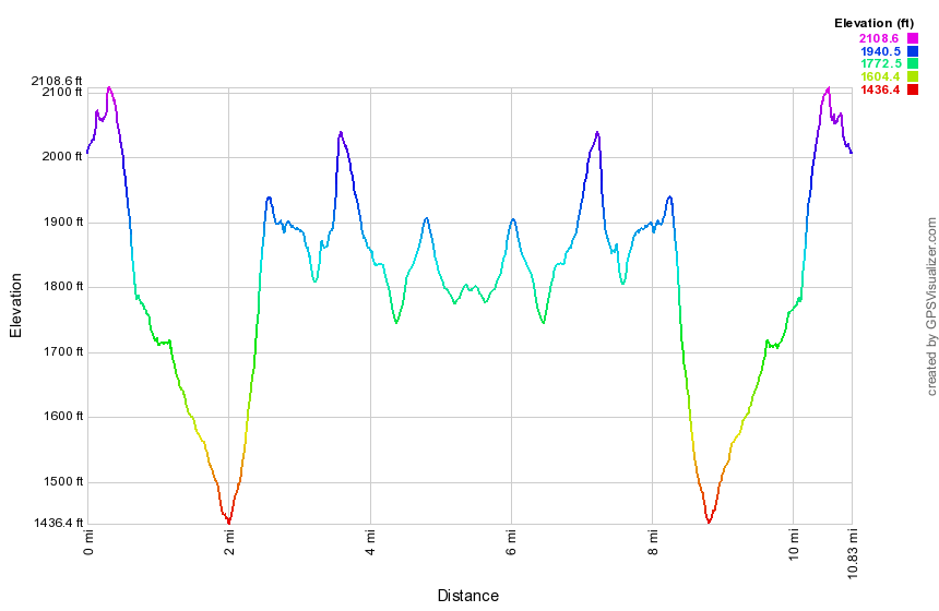 (The image shows the profile of the hike. Remember that all vertical profiles are relative!)
Middleburgh to Treadlemire Road
| Quick Look | |||
|---|---|---|---|
| Difficulty | Round trip | Total climb | Internet Maps |
| 11.5 mi. | 2370 ft. | AllTrails | |
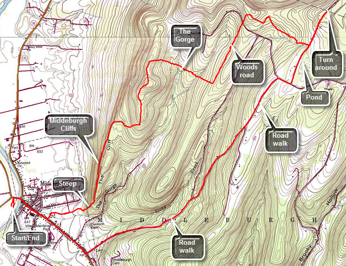
Head north on Route 30 through Margaretville, Roxbury, Grand Gorge, North Blenheim and Middleburgh. We turned right and then left to follow Route 30 through Margaretville, Roxbury, Grand Gorge and North Blenheim. Turn into Rotary Park just before the Route 30 bridge in Middleburgh. Walk behind the building near Route 30 and cross the bridge. Turn right on Main Street (Route 145 east) and walked about .6 miles until Straub Lane appears on the left. Turn left on Straub Lane and continue to follow it until it becomes MT Path. Continued to follow the aqua blazes toward the ridge in front of you. The blazes lead behind the last house and up a faint road toward a shale pit and a steep bank. The trail continues up the steep bank and starts to climb to the top of the cliffs. The blazes are very clear and the trail is usually cleared. You will find a dirt trail that ascends to a rock outcrop. At this point there is a narrow passage between the rocks which requires a big first step and then some upper body strength to get through the upper part of the passage. There is a nice viewpoint at the top with views of Middleburgh and Vromans Nose. Continue to walk along the cliffs on a nice wide woods road which continues to ascend. At about 2.2 miles turn west and then north again as the blazes continue to follow well-established wood roads. Other roads and paths cross at different points but the blazes are always clear. After reaching a high point at 3.2 miles turn from north to ESE onto a trail and off the woods road to descend to "The Gorge". Continue to descend eventually picking up another woods road and at 3.9 miles crossing "The Gorge". There is a pretty good sized ravine but the stream often has little or no water. At 4 miles make a right turn on woods road and start toward the northeast. Cross Durfee Road at 4.8 miles and begin a slight ascent. At 4.9 miles make another right turn and start to walk southeast. Just after the 5 mile point turn left on another woods road and watch for old well on the right side of the trail. This was constructed in the 1930's so that fire fighters could fill there "Indian tanks" from this water source. Around 5.5 miles turn onto a trail which parallels a streambed. Pass through some hemlocks and walk passed a house on the left before coming to Treadlemire Road at 5.9 miles. Turn left on Treadlemire Road and walk to the parking area about .5 miles up the road. Turn around here and walked back down Treadlemire Road. You may choose to return the same way you came or walk the roads back to the car. Continue down Treadlemire Road and turn right on Cotton Hill Road. You will now be on a long downhill walk back to Route 145 into Middleburgh. The road is paved and there are several short climbs. The trip to Route 145 is 3 miles of descent totaling almost 1200 feet! At Route 145 turn right and walked 1.1 miles back through Middleburgh to your car.
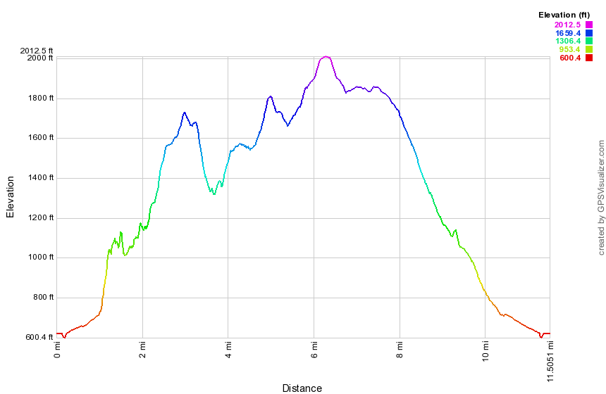 (The image shows the profile of the hike. Remember that all vertical profiles are relative!)
Snow Ridge Drive to Middleburgh
| Quick Look | |||
|---|---|---|---|
| Difficulty | Round trip | Total climb | Internet Maps |
| 11.7 mi. | 2360 ft. | AllTrials | |
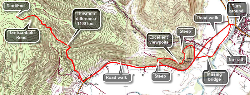
Head north on Route 30 through Margaretville, Roxbury and Grand Gorge. After passing through North Blenheim, watch for West Fulton Road on the left. Turn left on West Fulton Road and drive about 3 miles to the four corners in West Fulton. Turn right on Patria Road and drive the length of the road to the intersection with Greenbush Hill Road. Turn right and drive about .7 miles and turn right on Snow Ridge Drive. The "Private Property" signs on this road refer to the land and not the road since there is a state right-of-way. Where the road splits, stay right on the unnamed access road. The road is barely wide enough for one car! Within a short distance watch for a small, grassy parking area on the left. Head out the back of the parking area on the red trail. Within a few hundred feet you will come to the Long Path. Turn left and walk along a stone wall and immediately start to descend. Continue to hike downhill from an elevation of over 2000 feet and to Route 30 with an elevation of under 700 feet. This means that you lose over 1400 feet on the way out and have to regain the same elevation at the end of the hike. At about .5 miles turn right onto Hardscrabble Road which was abandoned many years ago.It is now overgrown and is not as well-defined as some other woods roads. As you continue to hike the blazes may become older, fewer and farther between. At about 1.8 miles exit the woods and start to walk down through a field watching for views of Vroman's Nose on the left. Continue straight ahead down the hill where some paths cross. At the road turn left to walk down to Route 30. Turn left on Route 30 to hike east toward Middleburgh. The traffic on Route 30 can be heavy but there is a nice wide shoulder. At 3.75 miles watch for the red trail on the left side of the road at the base of Vroman's Nose. The red trail is by far the steepest access to Vroman's Nose gaining over 400 feet in just the first .2 miles and averaging over a 30% grade. In places there really isn't much of a trail and the footing is unstable. It would be foolish to attempt this ascent without hiking boots and poles! The trip from the road to where the trail levels out is about .5 miles and the vertical gain is over 500 feet. As you begin to walk along the edge, various lookouts came into view but the best views are from the top. The views include the broad fields down below and the hills beyond with views stretching south to the Catskills. As you reach the end of the flat portion and begin your descent follow the aqua blazes down the very eroded trail. Vroman's Nose is a victim of its own success. A great many people visit this remarkable attraction but little has been done to improve or maintain the trails. Near the bottom continue to follow the aqua blazes to the right rather than the other trails that lead back to the parking area. At around 5 miles you will come out onto Church Street. Turn right to walk out to Route 30 where you should turn left. If you are attempting to hike this section, I suggest you do NOT follow the various trail descriptions or the route that I describe below! Turn left on Route 30 at the end of Church Street and stay on Route 30 into Middleburgh. There are problems with the trail that make hiking the actual route very frustrating. They are another example of the miscommunication between those marking the trails and those who write the descriptions. If you choose to try to follow the exact route of the Long Path, immediately turn right onto Mulberry Lane. Walk down this short and straight street for about .2 miles where it abruptly ends at a sign that says "Bridge Closed". There is no "new snowmobile bridge" across Line Creek. It seems to have been washed out some time ago. There was a short span on the other side and it is easy to cross Line Creek when the water is low. Walk over the span on the other side and turn right to walk along the edge of the field. This may be easier when the field does not have corn stalks 7 feet high! It is impossible to walk in the "woods" between the field and the creek. As you near Schoharie Creek, there are still no blazes and the situation is the same. Around 6 miles into the hike you will finally break out into an open area along the field and walk through some weeds to the Rotary Park. Continue through the park to the road bridge across Schoharie Creek on Route 30. Turn right and walk over the bridge to the intersection with Route 145 and then turned around to start back. You may retrace your exact path but this will require another trip back along the field and another ascent and descent of Vroman's Nose. An alternative is to follow Route 30 all the way back to Hardscrabble Road which also cuts a little mileage leaving you fresh for the 2 mile uphill trek at the end. At 9.5 miles into the hike you will be back at Hardscrabble Road. Turn right and walk a little way up the road then turn right again onto the path through the field. The final climb from Route 30 is 1440 feet over 2.1 miles
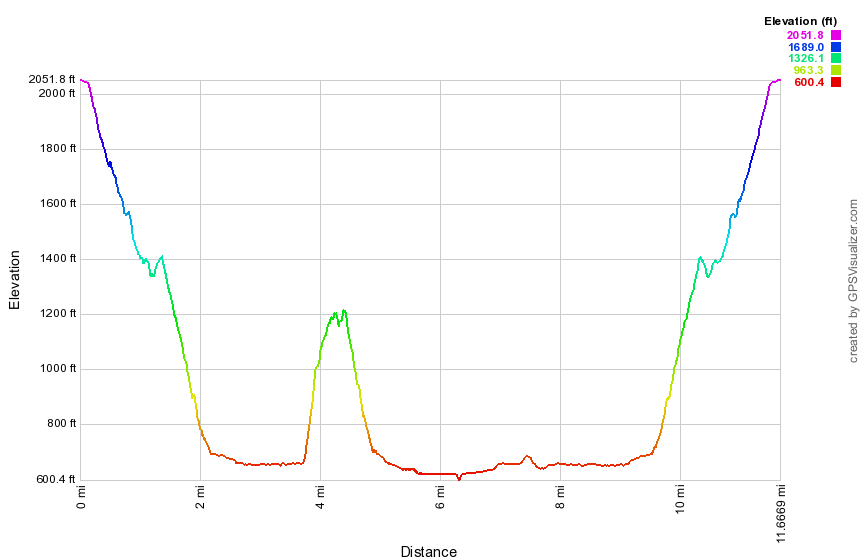 (The image shows the profile of the hike. Remember that all vertical profiles are relative!)
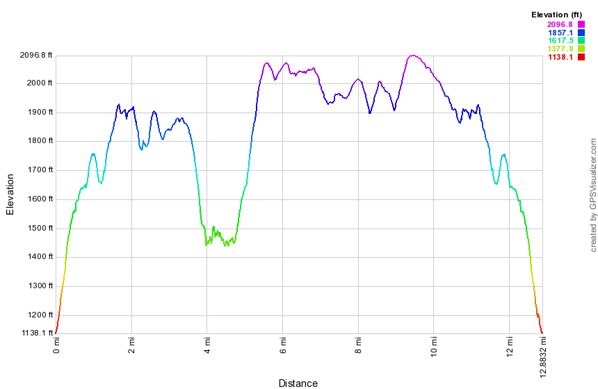
West Fulton to Snow Ridge Drive
| Quick Look | |||
|---|---|---|---|
| Difficulty | Round trip | Total climb | Internet Maps |
| 12.9 mi. | 2662 ft. | AllTrails | |
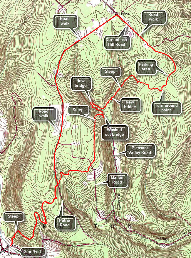
Head north on Route 30 through Margaretville, Roxbury and Grand Gorge. After passing through North Blenheim, watch for West Fulton Road on the left. Turn left on West Fulton Road and drive about 3 miles to the four corners in West Fulton. Turn right on Patria Road and cross a small bridge. Turn around and park on the side of the road where the Long Path turns left to go through a field. Enter the field and hike to a white pine tree with a white blaze. Several more blazes on pine trees lead to a pine forest and an immediate climb to a ridge. Within a little less than a mile the trail gains over 600 feet. The trail in this area is well-marked and easy to find as it follows old woods roads. At about .8 miles you will come out onto a woods road that is obviously being used for some purpose as it has recently been cleared. Turn left to walk uphill and then re-entered the forest on the right. The trail takes a dip at .9 miles and signs that say "State Forest" appear. This is Patria State Forest. Ascended again to about 1.7 miles and then descend a little to cross Patria Road at 2.15 miles. There are quite a few woods roads in the area which cross the trail and other places where the trail continues to follow a woods road. It is important to watch the blazes as the land up to the state forest is private. After crossing Patria Road head downhill where the trail begins to look a little less traveled and the blazes a little older. The trail heads east or northeast near a small seasonal stream through hemlocks. Cross the stream and begin to climb to the ridge again where the trail levels off briefly and crosses Mallon Road at 2.95 miles. Where you cross Mallon Road, there is a small parking area on the other side with a signboard which has seen better days. Entered another reforestation area on a woods road and start to head almost due north until 3.8 miles. The trail starts to descend to Pleasant Valley at 3.4 miles and at 3.8 miles turns east and continues to descend to 3.9 miles. The trail turns right or south and travels along the lip of a steep drop. Pass several roads going down the slope until the trail finally turns onto one of these just short of 4 miles. The road descends to a stream but the trail turns to the left just as the road makes a sharp right to go down to the stream. DO NOT follow the blazes down to the stream as this is the old route. No one has bothered to paint over these blazes and even "official" descriptions may not be updated. Turn left and follow the new blazes as they head upstream to the northwest and in about .25 miles follow them down to a new bridge across the stream. Just after you cross the bridge the trail turns southeast to head back downstream along what may be the old Pleasant Valley Road. Continue to the southeast until about 4.5 miles where the trail turns to the northeast off the "road" to continue on another woods road. The road leads to another new bridge across a large stream at 4.75 miles. After crossing the bridge, start an ascent along a nice woods road through pine forests heading northeast. At 5.2 miles the trail turns southeast but continues to ascend to 5.6 miles. The blazes in this area along this road are VERY few and VERY far between. At the top of the hill, the woods road and snowmobile trail continue straight ahead but the trail turns to the right. When you turn to the right it may be hard to follow the blazes and the trail since it seems to be little used. You will start to descend through a pine forest and may see a stone foundation on your left. Continue ahead until the trail turns to the right. Watch for a red blazed trail on the left which leads to a small parking area on a gravel road that acts as an access road to state land. At this point you may turn around and retrace your route. It may be quicker and more interesting to walk some of the roads. The route is a little longer but the walking is easier. From the parking area turn right on the access road and walk of to Snow Ridge Drive. Continue on this gravel road until it meets Greenbush Hill Road at 6.8 miles. Turn left and walk downhill along the road for about .7 miles where you should turn left onto Patria Road. This road is paved for a short distance but then turns back to gravel when it enters the state forest. The road is not all downhill but continues to ascend and descend hills along its length. For a mile from the intersection the road is completely straight and heads southwest. At 8.6 miles it turns to the south but continues to roll until it heads downhill to meet Mallon Road at 10 miles. The road is paved at this point as you continue downhill to 10.7 miles where the trail crosses. You may continue on Patria Road back to the car or turn right onto the trail. The distance on the road is somewhat longer but may be an easier walk. Turn right onto the trail and start a slight ascent. The trail levels some and then at 11.2 miles begins a long descent back to the car. You may be able to get a nice view as you turn onto the well-developed woods road. From here continue to follow your route from earlier in the day. The descent from the hemlock forest to the field may seem steeper than the ascent did earlier in the day.
 (The image shows the profile of the hike. Remember that all vertical profiles are relative!)
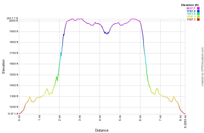
West Fulton to Old Cemetery Road
| Quick Look | |||
|---|---|---|---|
| Difficulty | Round trip | Total climb | Internet Maps |
| 8.2 mi. | 1388 ft. | AllTrails | |
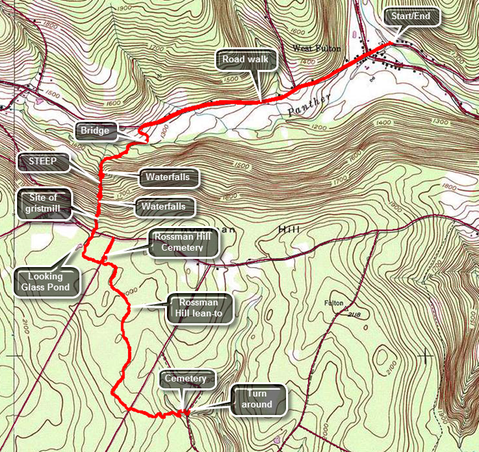
Head north on Route 30 through Margaretville, Roxbury and Grand Gorge. After passing through North Blenheim, watch for West Fulton Road on the left. Turn left on West Fulton Road and drive about 3 miles to the four corners in West Fulton. There is a small picnic area and playground on the right just before the STOP sign. You may park here or turn right at the STOP sign onto Patria Road. After crossing a bridge, park on the left side of the road where the Long Path turns left to go through a field. Walk back to the four corners and continue straight ahead on Sawyer Hollow Road gaining some elevation. At about 1.3 miles we pass a fishing access for Panther Creek and at 1.4 miles the Long Path turns left to descend through a field to Panther Creek. The grass had been mowed to form a wide path down to the creek. Near the creek the trail turns to the right follows the stream for about .1 miles where there is a bridge. The bridge is old but sturdy and built high enough above the creek that it must have withstood many storms. You will be walking through hardwood forest and soon the trail begins to climb and then climb steeply. The trail runs close to a small creek. Over the next .7 miles the trail gains 710 feet with the trail grade average over 17%. When there is a good volume of water in the creek, you can hear that the water flowing over the rocks. If you walk over to the edge of the stream, you can see several cascades and waterfalls. Continued walking up the trail and you will and many of these waterfalls with each one seeming to be nicer than the previous. Any description you read does not do these falls justice as you must seem them yourself. Near the top of the climb is the last water fall and you should notice a stone structure in the streambed. A waterwheel was been mounted here to power a gristmill. As you continue on the trail, it crosses Rossman Hill Road at 2.4 miles. On the other side of the road the trail may be wet in places and you will soon see a pond up ahead. The trail is a little indistinct but leads to the shore of Looking Glass Pond. Make a hard left and enter an evergreen forest. A sign at Rossman Hill Road indicates that the lean-to is about a mile from the road. Shortly after the pond the trail crosses Morey Road which is marked on some maps as Old Cemetery Road. The trail continues almost straight ahead but you may turn left to investigate the Rossman Hill Cemetery. The cemetery is overgrown with high grass and many of the stones are too worn to read. Other markers are legible and show that no one has been buried in the cemetery since the late 1800's. The site of the Methodist Church was just down the road from the cemetery and was disbanded in 1930. No trace of the church remains. Walk back to the Long Path to continue your hike. Shortly you will round a turn in the trail to find the Rossman Hill lean-to. It is in good shape but has no privy. The spring is further down the trail. After the lean-to the trail begins to head south and seems to follow some of the woods roads in the state forest. It veers off the road to the right to traverse some ground which is often wet. You will pass through or walked along a number of stone walls some of which are quite high. At 3.8 miles the trail finally turns east and starts to descend a little more steeply to a stream where there is no bridge. When the water level is low, crossing is no problem. Climb the far bank and you may be able to see a road through the trees. Continue to descend and approach the road where there is another cemetery. This one is smaller and probably older than the one on Rossman Hill. Walk down to the road and turned left to walk to where the trail enters the woods. At this point turn around and retrace your route back to the car as none of the roads in the area offer a shorter route. It should take less time on the way back since the trip is mostly downhill.
 (The image shows the profile of the hike. Remember that all vertical profiles are
relative!)
(The image shows the profile of the hike. Remember that all vertical profiles are
relative!)
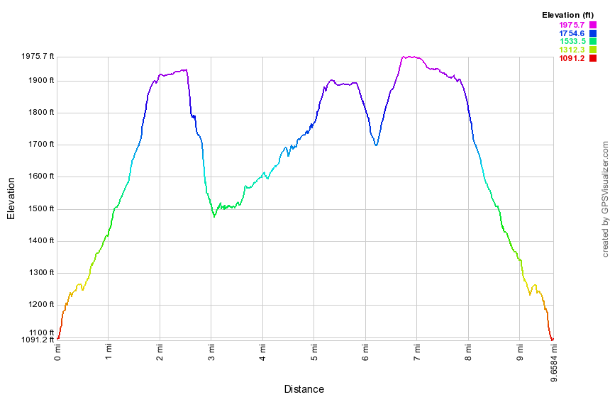
Doney Hollow to Old Cemetery Road
| Quick Look | |||
|---|---|---|---|
| Difficulty | Round trip | Total climb | Internet Maps |
| 9.7 mi. | 1770 ft. | AllTrails | |
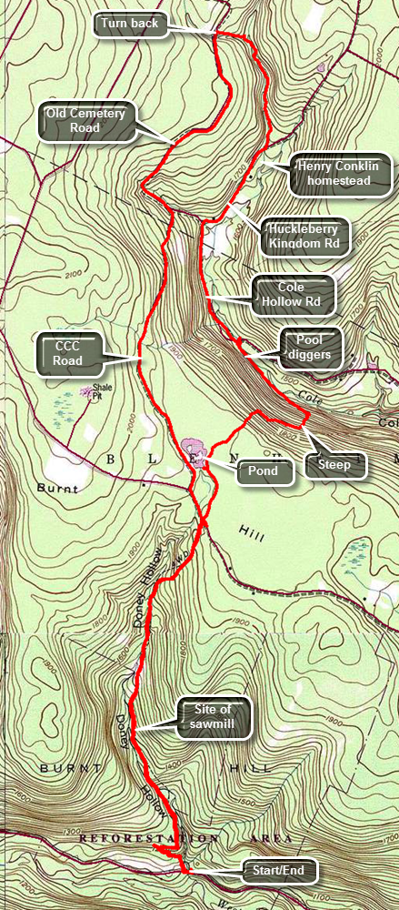
Head north on Route 30 through Margaretville, Roxbury and Grand Gorge. Just after coming to North Blenheim, turn left on West Kill Road and drive a little over two miles where there is a small pulloff on the left side of the road. Walk a little farther along the road and over a bridge to the point where the trail cuts right into the woods. The trail follows a woods road but after a short distance leaves the road to climb a bank. The woods road has been eroded by the small creek and all but disappears causing this detour. After another short distance, the trail rejoins the road. For the next 1.6 miles the trail stays mostly on woods roads paralleling a small creek. There are no majestic views over the countryside but there is a lot of evidence of past habitation. At about 1.25 miles there is a large pile of stones across the stream. This was once a dam and the site of one of two water-powered sawmills. On the other side of the trail is a set of stone steps that leads to a foundation. You will be passing by the summit of Burnt Hill. The area got its name from the frequent fires that were purposefully set in the early 1900's to improve the blueberry crops. Within a short distance, at about 1.9 miles, the trail crosses Burnt Hill Road. The road is little more than a single lane dirt and gravel woods road at this point. Cross the road and at 2.25 miles there is a short side trail on the left that leads to a small but pretty pond. A little passed the pond begin a rather steep descent to Cole Hollow Brook. In .6 miles you will have dropped over 400 feet and be at the edge of the brook. Turn left and walk another quarter mile northwest along the brook before the trail comes to Cole Hollow Road. Along the way there are several "pool diggers" in the brook. These artificial "waterfalls" oxygenate the water and help to erode small pools. Both of these actions help trout and other game fish to survive when the water level is low and the temperature rises. Turn left on Cole Hollow Road and walk to about 4 miles where the road turns left. Continue straight ahead on what is marked as Thomson Road on many maps. The old name for the road is Huckleberry Kingdom Road reflecting the importance of that "crop" in the area. Walk along this road for only about .5 miles where the trail turns left into the woods. Just before this turn there is a homestead on the right side of the road. This was the site of the home of Henry Conklin. Conklin authored the book Through Poverty’s Vale, which details the difficulty of living in area in the 1840s. The trail travels along a stream and there may be nettles to wade through since the trail is little traveled. Fortunately, the trail enters a pine forest and seems to follow a woods road which makes the hike more pleasant in several ways. At about 5 miles cross a small stream on a bridge and the trail intersects with a gravel road. You may turn around and retrace your path at this point or use the roads to form a partial loop. The road is marked as Old Cemetery Road on some maps and there is an old cemetery a little further up the Long Path. Turn right to hike south on Old Cemetery Road. Walking the roads is much easier than the trails particularly because of the level surface. At 6.3 miles stay right at a fork in the road to get on one of the many CCC roads in the area. This road has a very good gravel surface and is easy to walk although it heads uphill toward the pond and Burnt Hill. At 7.5 miles you will pass by the pond from earlier in the hike. Continue out to Burnt Hill Road and turn left to head back toward where the trail leaves Burnt Hill Road. Watch for the trail on the right which is only .1 miles from the intersection. The rest of the hike is a repeat of what you hiked earlier only in reverse.
 (The image shows the profile of the hike. Remember that all vertical profiles are
relative!)
(The image shows the profile of the hike. Remember that all vertical profiles are
relative!)
Creamery Road to Doney Hollow
| Quick Look | |||
|---|---|---|---|
| Difficulty | Round trip | Total climb | Internet Maps |
| 5.2 mi. | 860 ft. | AllTrails | |
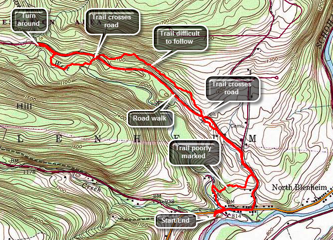
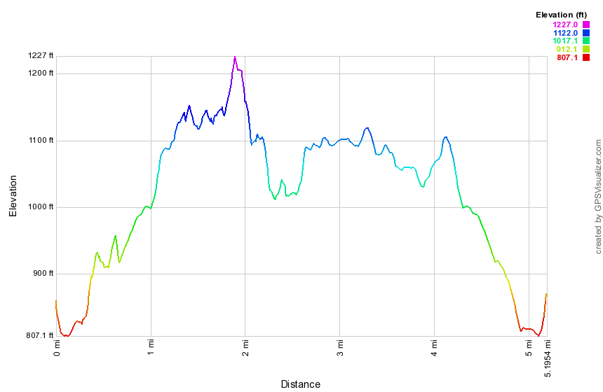
Head north on Route 30 through Margaretville, Roxbury and Grand Gorge. Continue on Route 30 passing Minekill Falls and Lansing Manor. Watch for the NYPA fishing access road on the right just before a bridge and the sign for Blenheim. Turn right and park on the shoulder of the road. Go back out to Route 30 and turn left to walk downhill to Creamery Road. Turn left onto this dead end street and watch for paint blazes on a few trees and poles. Just after the turn there is a rather large and old cemetery up on the right bank. At about .3 miles there are some blazes on the left although they may be hard to see. Head up a very steep bank and passed the cemetery on the right. Climb to some level ground and turn right to walk along the top of the ridge. This section may be VERY poorly marked so watch carefully for the blazes at about .35 miles. From this point the blazes are hit and miss and there is no trail to follow. At about .5 miles you will come out into a field where there are blazes along the edge. Walk to the corner of the field and turn left uphill at the edge of the field. At the top there is a single blaze on a tree but there was no indication of which way to turn. Turn right and look for a blaze on a tree. You may have to wade through tall grass to get to the treeline. Walk down a steep bank to come out to West Kill Road. Turn left on West Kill Road and begin a road walk. At .9 miles pass by the turnoff onto Burnt Hill Road on the right. At 1.15 miles the trail turns into the woods and ascends another steep bank through grass and briars to a small ridge. Walk along the ridge parallel to the road and within sight of it most of the time. The trail is in the woods for a little more than .1 miles then you will be right back out on the road. Cross the road and ascend another bank to start on a section of "trail" that is more like a bushwhack. Blazes are few and far between and blazes are missing at some important turns. The blazes pass above a pond where you will sidehill as best you can. At around 2.2 miles there is a single paint blaze on a tree and a choice of two equally distinct trails. Turn left and come to West Kill Road within less than a hundred feet. The trail crosses the road and an descend to the bank of the West Kill. After this descent, the blazes again become hard to find and the trail seems to meander around. The West Kill at this point is not spectacular. This section only lasts for .4 miles until you climb another steep bank. At 2.6 miles turn left on West Kill Road and walk to a small parking area near a bridge. Turn around here. You may reverse your route OR walk back on West Kill Road. The walk back on West Kill Road to Route 30 is 2.1 miles. At Route 30 turn right and walk back up the hill to the car.
 (The image shows the profile of the hike. Remember that all vertical profiles are
relative!)
(The image shows the profile of the hike. Remember that all vertical profiles are
relative!)
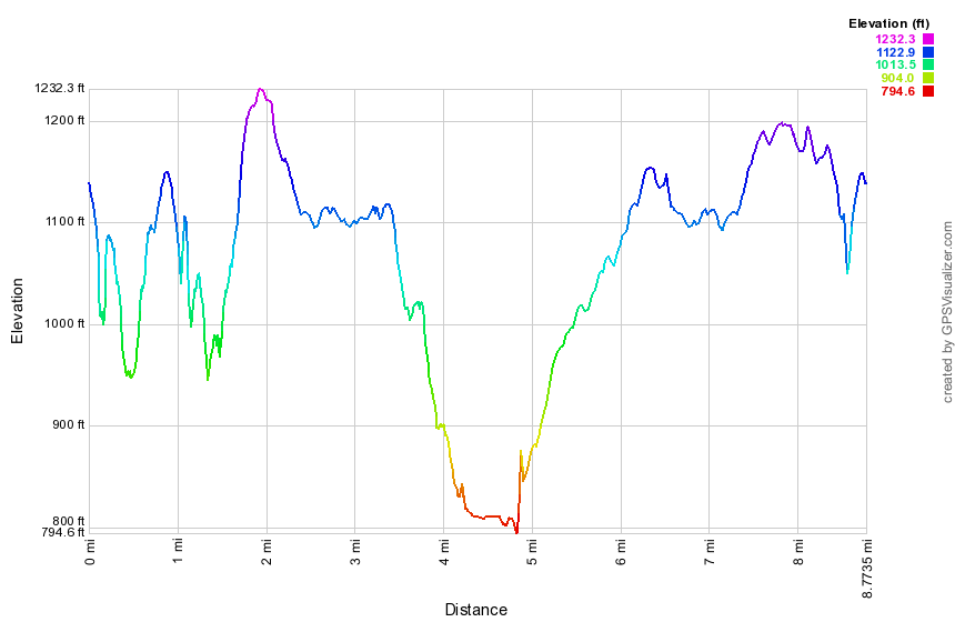
Mine Kill Falls to Creamery Road
| Quick Look | |||
|---|---|---|---|
| Difficulty | Round trip | Total climb | Internet Maps |
| 8.8 mi. | 1467 ft. | AllTrails | |
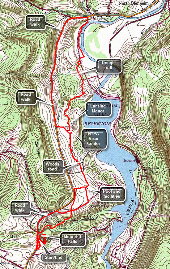
Head north on Route 30 through Margaretville, Roxbury and Grand Gorge. In about 6 miles watch for the entrance to Mine Kill Falls. Turn right to park in the parking area. If you want to view the falls, walk down the wooden stairs to the overlook platform. You may also walk back up to the top of the stairs and turn left to walk to the base of the falls. This part of the trail is also part of the Long Path. This walk will be about .85 miles. When you are ready, walk back toward the parking area. The Long Path has been rerouted to cross the Mine Kill on the Route 30 bridge as the crossing downstream proved to be unreliable. Walk out the entrance road for the park to Route 30 and turn right to cross the bridge. Just after the bridge the Long Path descends a steep bank on the right. The trail begins to descend through some evergreens and parallels the Mine Kill for about .5 miles. After a low point, the trail then starts to turn ENE and away from the creek. It begins to ascend gaining about 250 feet over the next .4 miles. At the top you will break out of the woods at the main access road into Mine Kill State Park. The Long Path continues straight ahead along a path mowed in the grass and parallels Route 30. The markings are pretty easy to follow. The park seems to be well-used and has a disk golf course to complement the pool, ball fields and courts. At 1.2 miles the Long Path turns right and heads downhill a little toward the soccer fields and picnic grove. Bear to the left toward a break in the trees which is a woods road where you will turn left at 1.4 miles. The path is clearly labeled and blazed. Walking this path is easy on the feet and you will soon come out of the trees to an open field with a series of cedar trees. The trees have been planted and protected by fencing to allow the deer to forage but not destroy the trees. Walked slightly up hill through the field to the Visitor's Center for the Blenheim-Gilboa Power Project. At about 2.1 miles into the hike you will pass the solar array and windmill. Walk over to the flagpole for a beautiful view down the Schoharie Valley and into the lower reservoir. Water is pumped from the lower to the upper reservoir during off peak hours. During high demand hours the water is released and turns turbines to generate power. From the flagpole walk in back of the Visitor's Center and then head a little left to walk in front of Lansing Manor. As you leave Lansing Manor, the blazes became harder to spot but the idea is to walk around the edge of the "lawns" to a break in the woods. There are paint blazes but you have to really strain to see them. At 2.6 miles enter the woods and find that the trail changes. The Long Path begins to drop dramatically and it is obvious the trail is not much used or maintained. At 2.8 miles you may have to fight your way through weeds and briars to a microwave tower. Just passed this point there is a nice lookout to the dam on the reservoir. Continue the descent through the woods and at 3.45 miles you will come to the New York Power Authority North Access Road. There is a small parking area. Cross the road and head to the left. Watch for the blazes that indicate you should cross the road and head down another steep bank as the trail nears Schoharie Creek again. There is a jumble of weeds and vines but these are usually cut back. Walk about .4 miles on the trail sandwiched between the road and the creek. At 3.9 miles the Long Path climbs to the road on a set of stairs. Turn right at the top and walk outside the guardrail to Route 30. You may turn around and reverse your route or use the roads for part of the return trip. Turn left on Route 30and be prepared for an ascent from the North Access Road almost all the way to Lansing Manor. At Lansing Manor you may continue on Route 30 but cutting back down to the rail is a better option. Walk the woods road back to Mine Kill. At the park walk out passed the pool to the main entrance road and then to Route 30. Turn left on Route 30 and hike the last .7 miles back to the car.
 (The image shows the profile of the hike. Remember that all vertical profiles are
relative!)
(The image shows the profile of the hike. Remember that all vertical profiles are
relative!)
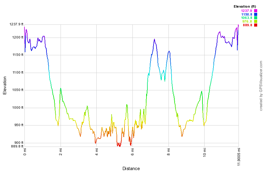
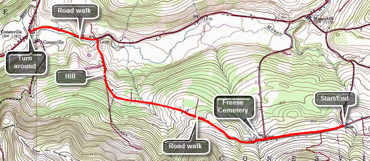
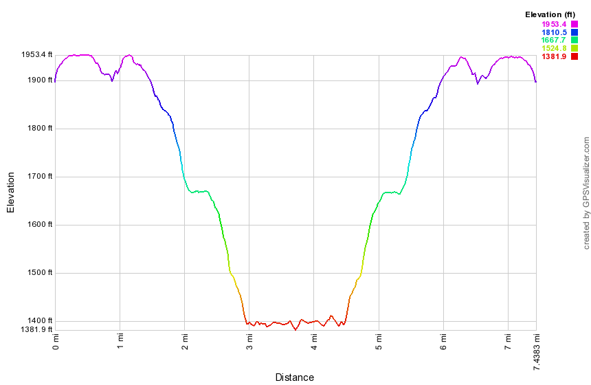
Manorkill Falls to Mine Kill Falls
| Quick Look | |||
|---|---|---|---|
| Difficulty | Round trip | Total climb | Internet Maps |
| 11.9 mi. | 1760 ft. | AllTrails | |
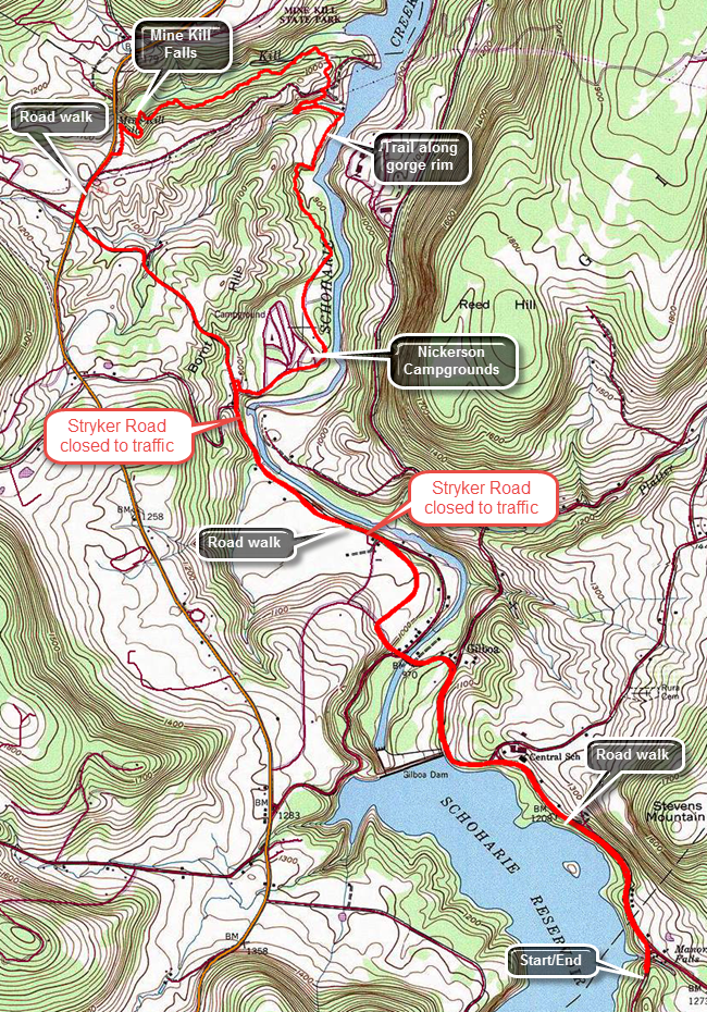
Head north on Route 30 through Margaretville, Roxbury and Grand Gorge. In about 5 miles after Grand Gorge turn right on Route 990V. Drive about 3 miles to Conesville and turn right on the Prattsville Road. Just after crossing the bridge, park on the side of the road. Walk back across the bridge to Route 990V and turn left to hike the shoulder of the road back toward Gilboa. The road has a lot of traffic and in most places the shoulder is wide enough. The road rolls a little until you pass the Gilboa-Conesville School on the right at about 1 mile. Just after this the road narrows for the ongoing construction on the dam. Start a descent to the post office. Just after the post office there is a small display of fossils found when excavating the reservoir. More fossils are in a small museum on Stryker Road. The museum in only open on summer weekends from 12:00 PM to 4:30 PM! The descent continues to 1.9 miles where you cross Schoharie Creek on a road bridge. From here walk up hill to the right turn onto Stryker Road. Stryker Road is now a dead end from both directions and is closed to through traffic. Walking on Stryker Road is a pleasure since the traffic is light. You will pass a large farm on the left that seems to have exotic animals. At about 2.6 miles there is a barrier that blocks traffic. Be careful as you walk around the barrier to the left as the right side of the road is collapsing into Schoharie Creek. There is more erosion downstream. Continue to walk down the road and at 3.1 miles there are a series of rock ledges at the side of the road. The second set is more interesting and shows that the road has all but disappeared. A little farther along the road is down to a single track for walking! From the road you can see a huge area of erosion ahead where an entire hillside seems to be in danger of collapsing into the creek! Shortly after this is another barrier as the road starts to ascend and moves away from the creek. Continue toward the Nickerson Park Campgrounds and at 3.5 miles turn into the campground. Follow the aqua blazes behind the store and down the main camp road. At one point you will cut to the right off the road onto a trail but then come right back to the road after a short distance. Just follow the blazes which are pretty clear through the campgrounds. Eventually you will run out of campground roads and enter the woods on a trail at about 4.4 miles. The trail can be muddy in spots and at about 4.75 miles there is a short but steep climb. At the top the trail levels and makes a sharp right turn to head directly for Schoharie Creek. At 4.9 miles there is a nice viewpoint upstream and down to the water at least 50 feet below. This continues for about a quarter of a mile. Soon the trail descends steeply and then makes a sharp left turn to run along the banks of a small stream parallel to the main creek. Walk upstream and watch for a rock shelf on the edge of the water which gives a nice view up and down the stream. Continue to walk upstream until a set of stepping stones crosses the stream. On the other side walk along the bank back downstream until the trail cuts up the bank. At the top of the climb you will be at a powerline right-of-way where the trail markers lead to the right and then left up the bank to the woods. At 5.8 miles you will be within sight of the Mine Kill and the trail makes a hard left and parallels the stream. The trail keeps climbing and at 6.7 miles passes the cutoff to the lower part of Mine Kill Falls. It is a quick walk to the parking area near the top of the falls. You will be at about 7 miles now and returning by reversing your route will make a 14 mile hike. To cut some mileage and make an easier walk continue out the entrance road to Route 30. Turn left and walk only about .4 miles on Route 30 to Stryker Road. It is another mile to the campgrounds on Stryker Road. Once you are back at the campground road, simply reverse the walk from earlier in the morning.
 (The image shows the profile of the hike. Remember that all vertical profiles are
relative!)
(The image shows the profile of the hike. Remember that all vertical profiles are
relative!)
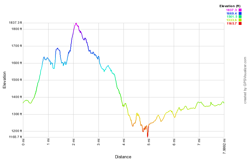
Conesville to Manorkill Falls
| Quick Look | |||
|---|---|---|---|
| Difficulty | Round trip | Total climb | Internet Maps |
| 11.9 mi. | 1760 ft. | AllTrails | |
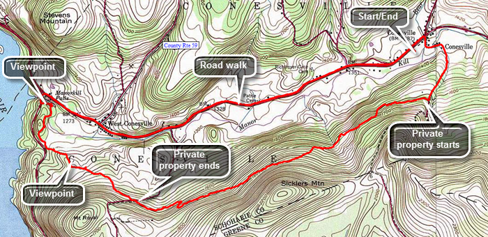
Follow Route 30 through Margaretville, Roxbury and Grand Gorge. Turn right on Route 990V and drive through Gilboa and West Conesville. Three miles after the intersection with the Prattsville Road you will be in Conesville. Park in parking lot at the firehouse as far out of the way as possible. Walk east on the main road to Champlin Road and turned right. The road has a hardpacked dirt surface and there are only a few houses near the beginning. Watch for the point where the Long Path turns right off the road. This happens after walking past a driveway on the right at about .8 miles. Just off the road is a sign explaining the trail is now on private property. There is also a small mailbox and a request for hikers to "sign in". The next 2.7 miles of hiking is through private land as the Long Path heads almost due west and just to the north of Sickler's Mountain. The route is downhill most of the way. In this area, as in so many others along the Long Path north of the Catskill Park, there really isn't a trail. There may be paint blazes on the trees but there is little evidence that a trail was constructed or that anybody walks the route very much. There is little or no maintenance in most places. It can be very hard to watch the blazes and watch your footing at the same time. At 2.2 miles you will pass north of the summit of Sickler's Mountain and there are some very interesting cliffs on the left. Remember not to violate the property owner's request that hikers stay on the "trail". Follow the paint blazes which are often placed along old woods roads. There are many more open areas which may be heavily populated by briars and nettles! As you get closer to Pangman Road there are a few places to get some views by walking off the trail. Pangman Road is about 3.5 miles into the hike and the straight line distance to Manorkill Falls is almost exactly a mile. Walk downhill from Pangman Road for .85 miles until we you can see Prattsville Road ahead through the trees. Just before you get to the road the trail comes very close to the edge of the gorge cut by the Manorkill. The Manorkill usually flows slowly and lazily below and, in its present state, does not look like it could have cut such an impressive ravine. As you approach the road, the blazes turn north to almost parallel the road. The first part is simply a zigzag through numerous blowdowns. After that, the blazes take you within sight of the Manorkill again near the area of the upper falls. The land below the trail is marked with orange paint so continue to a spot where there is a lookout down into the gorge. Several different viewpoints provide good opportunities to take pictures of the falls and rapids. Continue out to the road and turn right to walk over the road bridge. You may want to stop on the bridge and look to the right for a better view of the upper falls. The main falls is just below the bridge and it is hard to see. Walk out to Route 990V and turn right to head towards West Conesville and the Conesville. The entire walk is about 3 miles. This road always seems busy but in most places it has a wide enough shoulder.
 (The image shows the profile of the hike. Remember that all vertical profiles are
relative!)
(The image shows the profile of the hike. Remember that all vertical profiles are
relative!)
South Mountain Road to Conesville
| Quick Look | |||
|---|---|---|---|
| Difficulty | Round trip | Total climb | Internet Maps |
| 7.4 mi. | 750 ft. | ||
Head north on Route 30 through Margaretville, Roxbury and Grand Gorge. In about 5 miles after Grand Gorge turn right on Route 990V. Pass the Schoharie Reservoir heading east towards Conesville. After passing the turnoff for the Prattsville Road near Manor Kill Falls, drive another 3.8 miles through Conesville and turned right on South Mountain Road. Drive three miles to Cook Road on the right and a CCC or woods road directly across from it. Park on the woods road as far to one side as you can or park on the shoulder of Cook Road. Start walking back toward Potter Mountain Road on South Mountain Road. The trip out is mostly downhill making the return trip an uphill climb. There are a few interesting "attractions" along then road. Within the first half mile there is a cemetery on the right which seems to show more care than some of the others on the trail. Some houses along the road are obviously occupied while others seem to be second homes or deserted. Some of the houses are new and well-kept while others are older and run down. One house has a wrought iron fence around it and what were once tennis courts on the other side of the road. Everything is slowly decaying but there is no "For Sale" sign on the property. There is even one farm along the road. From Haner Road the South Mountain Road descends more steeply. It is almost exactly 3 miles to the intersection of South Mountain Road with Potter Mountain Road, the extension of Route 990V in this area. Turn left on Potter Mountain Road and walk .7 miles into Conesville to Champlin Road on the left. Since there are some opportunities to park in the area, this is a good place to turn around and walk back to the car. It also leaves a reasonable hike from Conesville to Manorkill Falls and back.
 (The image shows the profile of the hike. Remember that all vertical profiles are relative!)
Route 10 to South Mountain Road
| Quick Look | |||
|---|---|---|---|
| Difficulty | Round trip | Total climb | Internet Maps |
| 12.8 mi | 2730 ft | AllTrails | |
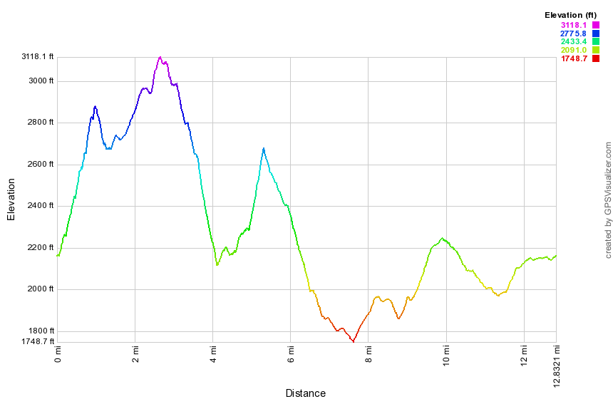
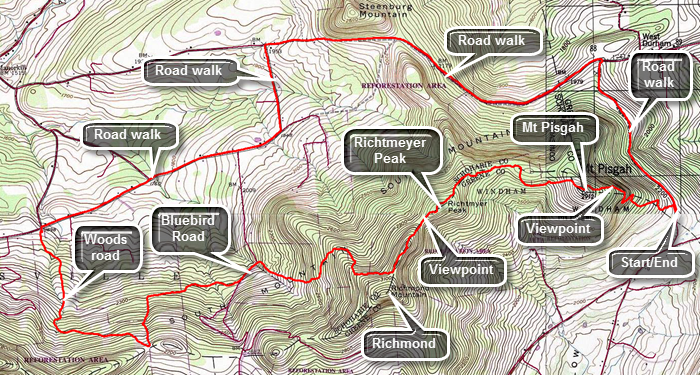 In the village of Windham find Route 21 north. Drive 4.5 miles north and turn right onto Route 10. Route 10 will make a sharp left up a hill. Park in the first pulloff on the right about .6 miles after Route 21 merges with Route 10. The trail crosses just north of the pulloff. For the first .7 miles the trail wound its way up the eastern shoulder of on Mount Pisgah. A short distance from the road there is a set of low cliffs but the trail turns right and then leads us up through a gap in the rocks. Several switchbacks use old woods road to ascend the mountain. At about .7 miles the trail starts along the northern shoulder of the mountain. At .75 miles the trail turns to the left and stars the climb to the summit of Mount Pisgah. Just at this point there is a limited viewpoint to the north. Pass across the summit at about 1 mile but don't expect any views as the summit is overgrown with pine trees. Descend from the summit about 200 feet to a col and then begin to climb to Richtmeyer Peak which is slightly higher than Mount Pisgah. Most of the forest here is hardwood with some evergreens mixed in. At 2.3 miles cross over the summit. Just passed the top there is a limited view to the south toward the Blackhead range. The trail has been heading west most of the hike but now shifts to the southwest on the descent off Richtmeyer and towards the northern peak of Richmond. At 2.65 miles you will be at the highest point of the day at over 3100 feet. Continue southwest toward the main peak of Richmond. At 2.9 miles the trail turns west and becomes a little wet as it hugs the northern shoulder of Richmond. The Long Path does not go over the main peak of Richmond but it is a short bushwhack to the summit. Pass by the summit and at 3.1 miles the trail heads north on the start of a steep descent. The trail loses 860 feet in a mile. After the descent the trail eventually hits a woods road and then Bluebird Road at 4.1 miles. Turn left on Bluebird Road for about .2 miles where the Long Path turns right into the woods again. Initially it follows a woods road which soon becomes a trail heading west. At 4.6 miles begin to ascend gently to 5 miles. Here the trail turns south and begins to ascend much more steeply on a 20% grade. There are hardwood forests here that give way to a pine plantation. In .4 miles gain 390 feet coming out into an open area at the top. The old route of the Long Path to Ashland Pinnacle and Huntersfield is ahead slightly to the right and marked in red. The Long Path turns right and starts down a dirt road toward South Mountain Road. The road starts to the west before turning north and in 1.4 miles meets South Mountain Road. At this point you may turn around and retrace your route back to the car. Walking the local roads back to the car is shorter and much easier. Turn right on South Mountain Road to walk the 1.75 miles to Toles Hollow Road. There are some nice views of the route you just hiked on the right. Just before your turn there are some views to the north. Turn left and walk downhill briefly and then uphill to the Durham Road. At 9 miles into the hike turn right onto the Durham Road to head east for about 2.5 miles to Route 10. The views to the north along this route are beautiful. Over the 2.5 mile walk you will hike up over a "bump" but then descend down the other side. At 11.6 miles turn right onto Route 10 for the final 1.2 mile walk back to the car. There is still some elevation gain although it isn't much. Watch for some nice views to the east. Continue on the road back to the car.
 (The image at the left shows the profile of the hike. Remember that all vertical profiles are relative!)
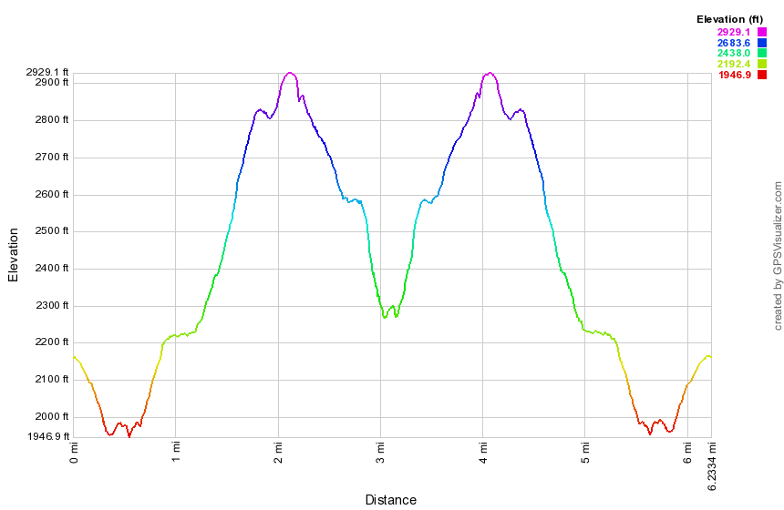
Route 10 to Barlow Notch
| Quick Look | |||
|---|---|---|---|
| Difficulty | Round trip | Total climb | Internet Maps |
| 8.2 mi | 1864 ft | AllTrails | |
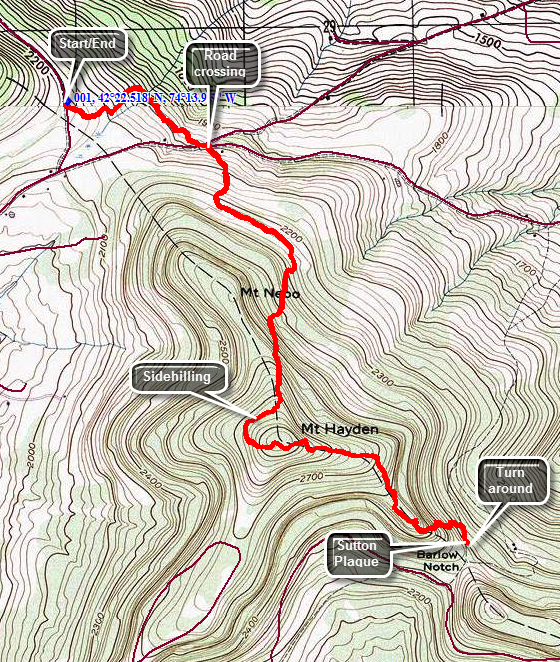 In the village of Windham find Route 21 north. Drive 4.5 miles north and turn right onto Route 10. Route 10 will make a sharp left up a hill. Park in the first pulloff on the right. The trail crosses just south of the pulloff. The first .7 miles of trail descends through some hardwoods and then is flat until the junction of Cunningham and Sutton Roads. Walk across the road intersection and pick up the trail on the other side. It starts out on an old road but quickly turns right into the forest and over the next 1.2 miles gains over 850 feet. The trail passes east of the summit of Mount Nebo in a generally south or southeast direction. You will start to ascend Mount Hayden by sidehilling around the west shoulder and passing the summit. The trail turns sharply east and climbs the final 125 feet to the top. There are no viewpoints along the way although there are some places where views might be available when the leaves are off the trees. The summit of Mount Hayden is 2.1 miles into the hike. Along some parts of the trail blazes are few and far between in some critical places. Over the next mile the trail heads first east and then southeast on a one mile descent to Barlow Notch. You will lose 675 feet and walk through some steep sections and some switchbacks. Near the bottom of the descent the trail meets a woods road which is actually marked on some maps and GPS devices. Continue on the trail watching for the Sutton plaque on the left side of the trail. The plaque is not far from where the trail meets the woods road about 3.1 miles from the car. Turn around and follow the trail back toward the car. By the time you get back to Cunningham Road and climb the last .7 miles to Route 10 the ascent may seem a little more challenging than you thought it might be.
 (The image shows the profile of the hike. Remember that all vertical profiles are relative!)
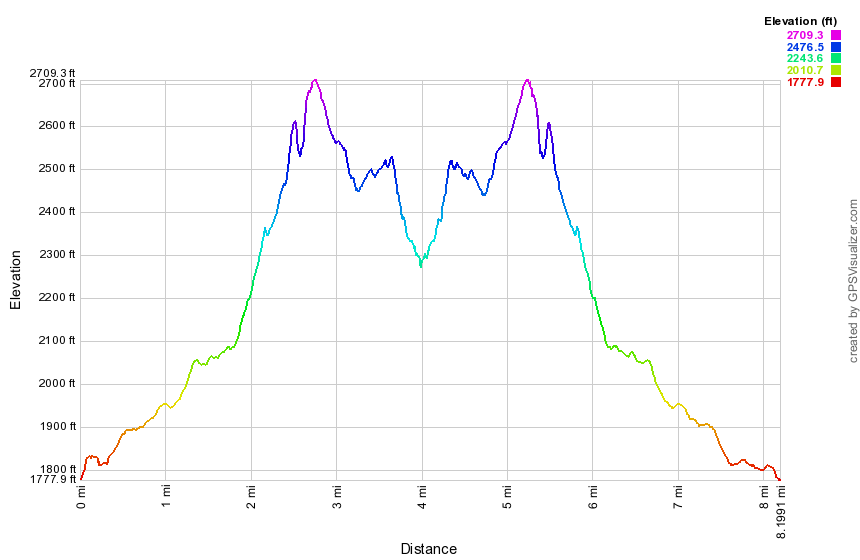
Windham to Barlow Notch
| Quick Look | |||
|---|---|---|---|
| Difficulty | Round trip | Total climb | Internet Maps |
| 8.2 mi | 1864 ft | AllTrails | |
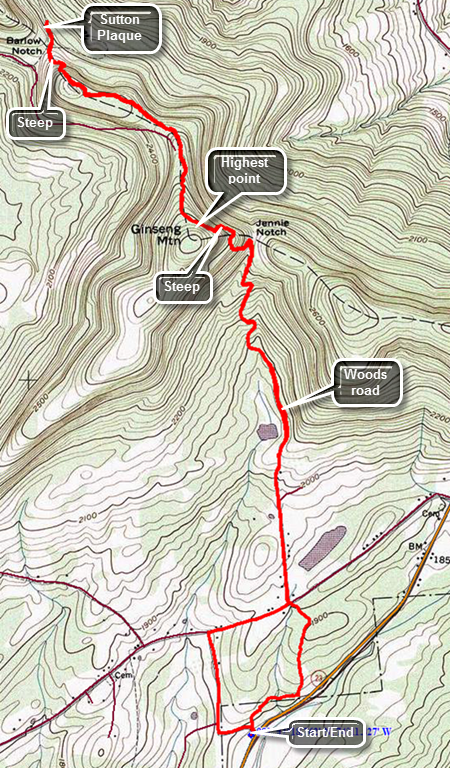 Drive east on Route 23 from the village of Windham. Watch for the Elm Ridge parking area and Cross Road on the left or north side of the road. Park in the parking area and when you are ready walk to Cross Road. Cross the road and find the trail marked with blue plastic discs as well as the aqua blazes of the Long Path. The first .33 miles is pretty flat and actually parallels Route 23. The trail is not always well-maintained and can be overgrown. In addition, the area can be very damp during wet seasons which seems to attract insects. The trail turns north and begins to rise but only slightly. Walking through the evergreens may remind you a little of some of the places over on Windham High Peak. At .75 miles you will come out of the woods and cross Old Road to Jennie Notch Road. The trail follows Jennie Notch Road to where it dead ends. There is a small pond or lake on the right with a mountain behind it which can be quite picturesque. The paved road soon turns to dirt and then ends at about 1.3 miles where there is an open gate. The road actually continues as a grassy lane which is easy to follow even though the blazes are few and far between. Initially the grade of the road is gradual. It is obvious that the road was important and built up with a shale base at some point. You will pass a small pond on the left with some very limited views through the trees. Starting at 1.8 mikes the grade increases until Jennie Notch at about 2.4 miles. Along the way you can see some cliffs on the left which defines part of Ginseng Mountain. There are several switchbacks along the way but at the Notch the trail turns to the left more than 90 degrees. It begins to head up the mountain and soon the grade is 30% or more! This doesn't last very long and between 2.6 and 2.8 miles the trail begins to sidehill along the north shoulder of Ginseng Mountain. The trail levels a little at the top and then starts to descend. The Long Path in this area is overgrown with low briars and nettles and there are several blowdowns. Over the first half mile you will lose about 260 feet from the highest point on the hike. You will be walking along a ridge with no real views. On either side of the trail you can see sky as the ridge is not very wide. In winter there are limited views since the leaves are not a factor. After the descent the trail gains some elevation and then starts the drop to Barlow's Notch. On the descent look to the right for the best view of the day. The trail down to the Notch has several steep places. You will be at he Notch at about 3.9 miles. If you continue to walk a little farther there is a small memorial plaque to local resident Donald Sutton. You will have dropped 530 feet from the top of Ginseng Mountain. Reverse your route and remember that after the climb to the high point on Ginseng Mountain, the return trip is all downhill or flat. At the point where Jennie Notch Road meets Old Road you can reenter the woods or use the roads to return to the car. At the intersection turn right on Old Road, walk down to Cross Road and follow it back to the parking area. The distance on the roads is a little longer but the time is quicker.
 (The image at the left shows the profile of the hike. Remember that all vertical profiles are relative!)
Windham High Peak from Route 23
| Quick Look | |||
|---|---|---|---|
| Difficulty | Round trip | Total climb | Internet Maps |
| 7.3 mi. | 1860 ft. | ||
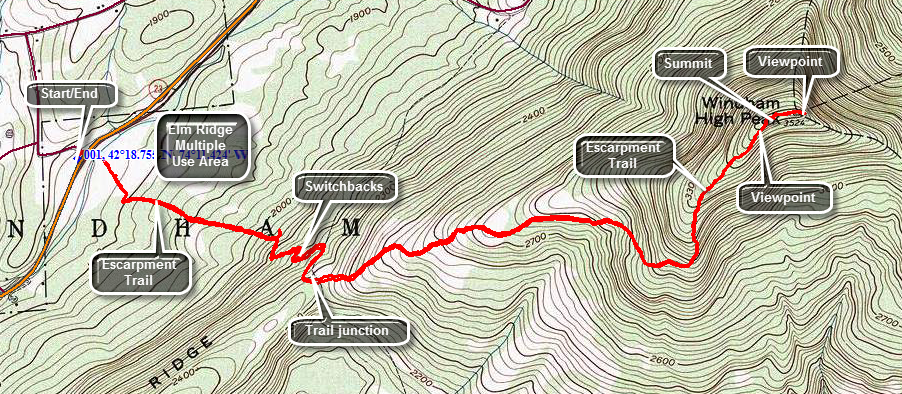
Drive east on Route 23 from the village of Windham. Watch for the Elm Ridge parking area and Cross Road on the left or north side of the road. Park in the parking area and when you are ready walk across Route 23 to the blue blazed Escarpment Trail on the other side of the road just opposite Cross Road. The first part of the trail crosses over a wetland on abridge and some walkways. You will come to a kiosk and a set of trails that branch from the main trail to Windham. These trails are multiuse trails popular with local residents for walking and also used by mountain bikers. Stay on the main trail which after .3 miles begins to get steeper on its ascent up the mountain. The ascent never gets very steep but it is constant as the trail passes through mostly hardwood forests to a trail junction. A few switchbacks along the way moderate what might be a steeper ascent. At about 1.5 miles the Elm Ridge Trail intersects the main Escarpment Trail. There is a lean-to on the right at this junction. Turn left on the Escarpment Trail and stay on the trail for 2.4 miles to the summit of Windham High Peak (3524 ft.) This trail winds through some boggy areas where old log foot "bridges" are slowly rotting away. The woods turn from hardwoods to pines and then back to hardwoods again. The area under the lines can be "spooky" and there are plenty of roots to avoid. Then final climb up Windham gets a little steeper but the views that reward you are worth the climb. Once you reach the summit plateau continue to hike across the top until the trail begins to drop again. Along the way you will be treated to a view on the right to the south which reveals the entire Blackhead Range. A little after this viewpoint is the summit of Windham. DO NOT turn around here as the next viewpoint is only a few hundred feet away. This viewpoint on the left of the trail takes in the area to the north of the Catskills. On a clear day Albany is visible as are the mountains from Huntersfield to Mount Pisgah. After taking in the view, turn around and retrace the same route to the parking area.
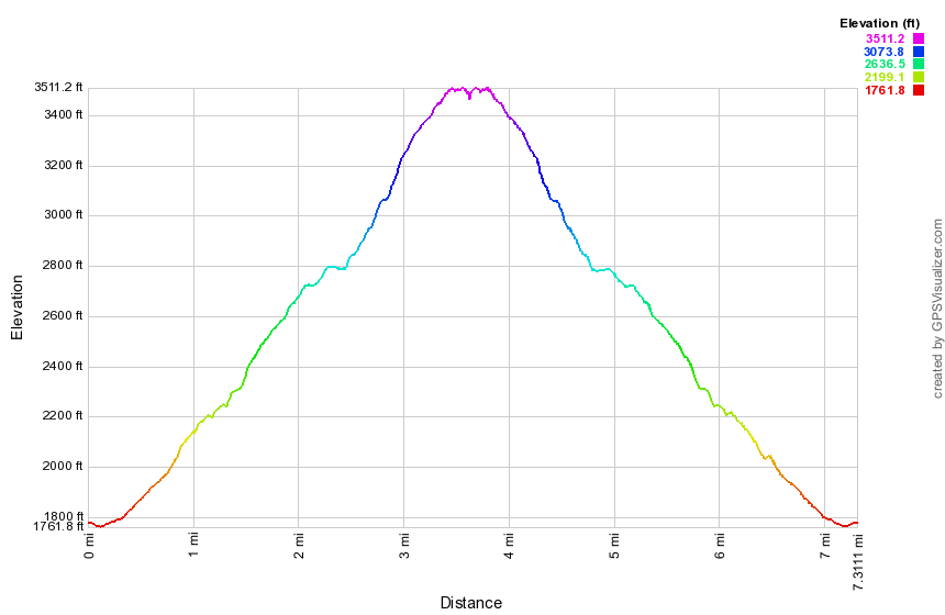
(The image at the right is the vertical profile for the entire hike starting at the Route 23 PA.)
Windham High Peak and Blackhead from Batavia Kill
| Quick Look | |||
|---|---|---|---|
| Difficulty | Round trip | Total climb | Internet Maps |
| 10.8 mi. | 3400 ft. | AllTrails | |
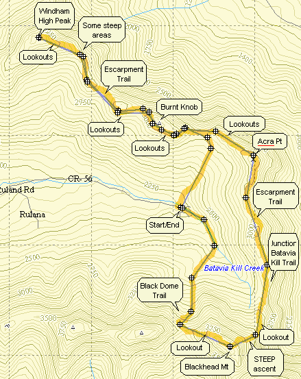
From Rt. 23C take Maplecrest Road north to Maplecrest and then turn right onto Big Hollow Rd. Go to the "end" of Big Hollow Road and park in the parking area on the right. You may also use the snow plow turn around on the left when there is no snow. On the left side of the road find the trail head for the red-blazed Black Dome Trail. The first water crossing across Batavia Kill is on a bridge so there is no problem. Right after the bridge and trail register you must cross a small tributary which can be all but impossible during high water. If you cannot cross here, you may be able to bushwhack along the left side of the stream to an easier crossing. After about a mile the Black Dome Trail ends at a T with the blue-blazed Escarpment Trail. Turn left toward Burnt Knob and Windham High Peak. The climb up Burnt Knob is short but can be tricky. In the winter the narrow trail is hard to negotiate with snow shoes. In the drier seasons the loose dirt in some areas makes falling very easy. After about .25 miles there is a side trail to the left which offers a beautiful view of the Blackhead Range to the south. Back on the main trail you will begin to descend from Burnt Knob in only .1 miles. There is a view of Windham just as you begin to descend. The view is much better when there are no leaves on the trees. After about 1.5 miles of most flat walking the climb up Windham begins. There are several spots along the way that offer views; some better than others. One spot in particular is about halfway between Burnt Knob and Windham. Walk off the trail to the right and a rock ledge offers wonderful views to the north and east. The climb up Windham gets steeper at times but a few switchbacks help out. The distance is less than a mile and Windham is only 3524 ft. in elevation. As you near the top there are two nice lookouts on the right. Continue on to a big pine tree near the top that marks the highest spot on the peak. Retrace your steps to the lookouts and enjoy the view. To get back to the junction with the Black Dome Trail just reverse your course and return the way you came. At the trail junction continue straight ahead on the Escarpment Trail as it ascends Acra Point. There are some nice views of the valley from lookouts on Acra Point. At 7.9 miles into the hike the Batavia Kill Trail departs to the right. Stay on the Escarpment Trail by continuing straight ahead and get ready for the most challenging climb of the hike up the east side of Blackhead. This part of the Escarpment Trail begins to ascend almost immediately and although it does level out after the first ascent it then becomes VERY STEEP. It rises around 1300 feet in less than one mile. At 8.6 miles you will be at the open rock that marks the summit of Blackhead. Signs here indicate that the Escarpment Trail goes to the left. Turn right on the Blackhead Trail which takes you across the summit plateau and then down to Lockwood Gap. Along the way there are some lookouts which have nice views of Black Dome. At the trail junction in Lockwood Gap turn right to take the Black Dome Trail back to the parking area. The walk back to the car is about 1.6 miles but it is all downhill dropping over 1200 feet!
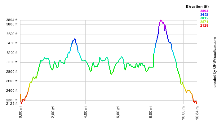
(The image is the vertical profile for the entire hike starting at the Batavia Kill PA.)
Blackhead from Colgate Lake
| Quick Look | |||
|---|---|---|---|
| Difficulty | Round trip | Total climb | Internet Maps |
| 13.8 mi. | 2650 ft. | AllTrails | |
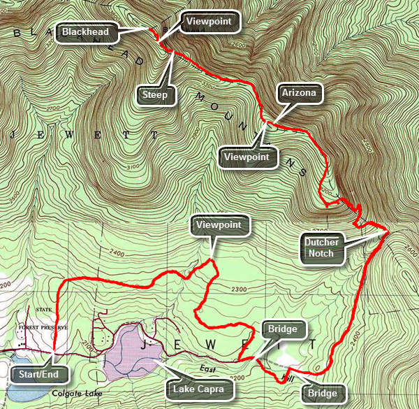
From Route 23A in Tannersville head north on County Route 23C. The road ascends to a stone chapel at the top. The views of the Devil's Path from the stone chapel are worth a quick stop. As you drive down the other side of the hill from the chapel, watch for Colgate Road which is also marked as County Route 78 on the right. Turn right and drive 1.7 miles to the parking area for the hike on the left. The parking area is just passed Colgate Lake which is on the right. From the parking area there are some nice views of Blackhead in the distance. Walked out the end of the parking area to cross a field before walking into the woods. The initial part of the trail is largely an old woods road. The trail follows this road but is somewhat circuitous to avoid the private inholding of Lake Capra. The road connected the fertile Jewett Valley with the markets on the east side of the Escarpment by passing through a gap called Dutcher's Notch. The first bridge is at 1.25 miles followed by a second at 2.0 miles. Just after the 2 mile mark the trail is often very wet with standing water and mud. It is possible to avoid walking through much of it by staying on the sides of the trail or taking a slight detour. At about 2.3 miles there is an evergreen forest and a large beaver meadow on the left with nice views of the Escarpment, Arizona and the Blackhead Range. At 2.5 miles there is a third bridge over the East kill or one of its smaller tributaries. There is a beaver pond on the left of the trail on the other side of the bridge. Shortly after this there is a fourth bridge made up of two logs after which the trail takes a sharp right onto an old road. A field on the left offers some more great views of the Blackhead Range. A little farther along there is a small falls on the right of the trail. The trail/road here was a lot of rocks making the walk a little tricky. For the next 1.5 miles the trail ascends toward Dutcher Notch and begins to climb a little more seriously. In many places high stone cliffs rise on either side. In other places there is a deep gorge on the left side of the trail. After 4.25 miles there is a junction with the Escarpment Trail. Turn left and start to gain some real elevation on the climb to Arizona. There are some beautiful views, several switchbacks and a few scrambles up and over rocks. There was even a "tunnel" in one spot. When you reach the plateau near the top, there are nice lookouts at the 5 mile mark. Lake Capra is visible just below the viewpoint and on a nice day the Hudson can be seen. For the next .8 miles there is about a 300 foot elevation gain as the trail follows the narrow spine of the escarpment and the Blackhead Range. After this there is a drop of over a 100 feet and then a gentle climb up toward Blackhead for .75 miles. At this point the climb begins to get steep all the way to the summit of the mountain. For the next half mile there is a gain of 500 feet. There are two areas before the summit that look remarkably like the top but are "false summits". The second has the legend "Camp Steel 1936" painted in white on the rocks. Once you are at the true summit there isn't much to see. To complete the hike turn around and follow the same route back to the car.
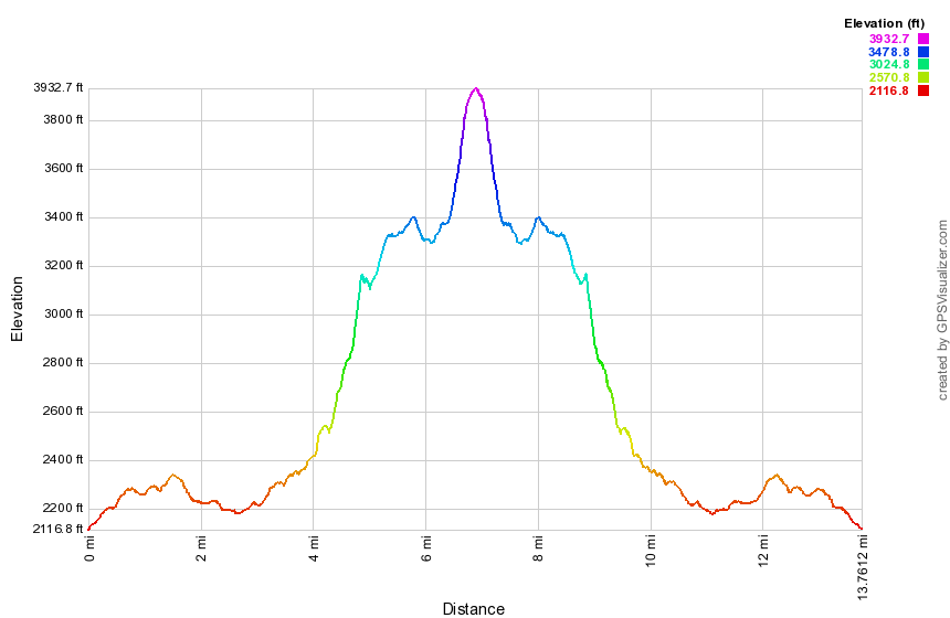
(The image is the vertical profile for the entire hike starting at Colgate Lake.)
Winter Clove: Winter Clove Falls and Escarpment Loop
| Quick Look | |||
|---|---|---|---|
| Difficulty | Round trip | Total climb | Internet Maps |
| 12.1 mi | 3642 ft | AllTrails | |
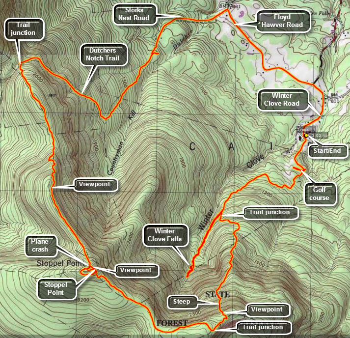 From State Route 32 north of Palenville turn west on County Route 31 Hearts Content Road just north of the Friar Tuck Inn. Turn southwest on Winter Clove Road and stay on Winter Clove Road all the way to the end. Park at the Winter Clove Inn. This is a PRIVATE resort and all the trails start on PRIVATE property. Go to the front desk in the main building and ring the bell. Ask politely if you may park and hike. The INN will even allow you to take the descriptions they have of their trails.
This hike starts by heading out across the field from the parking area by the building across from the Inn. As you walk back toward the Inn there will be a building on the left. Walk up the path next to the building and then up the gravel/dirt road that runs alongside the golf course. When the road splits, take the up branch to the left and walk up to another part of the course. Walk across the course, avoiding the greens, toward the upper left corner of the open space. You are looking for the SIXTH TEE. Pass through some trees and cross two small bridges. Walk down the fairway and take the first trail to your right. Walk up a small hill and then into a field or clearing. Walk along the left side of the field and look on the left for an old sign that says Webster's Pass. Turn left here and walk along an old road. A sign on the right says North Point and Winter Clove Falls. Turn right here at about .6 miles into the hike. From here the trail climbs a little and then starts downhill, At about .8 miles the trail turns to the left at a sign again designating North Point and Winter Clove Falls. From here the trail climbs steadily using old woods roads until at 1.35 miles it splits. Bear to the right toward Winter Clove Falls. Along the way you may hear the roar of the water of a creek to your right and, at times, you may see the water forming small drops and rapids along the way. At 1.65 miles the trail descends a little and crosses an old creek bed with several downed trees. From this point on the trail markers are scarce and a little faded but continue to follow the creek bed.You will keep getting closer to the creek and should see glimpses of the falls ahead. The trail climbs steeply at this point to the top of the falls. There is a view along the clove out into the valley toward the Hudson but how could the view is depends on the lighting and the amount of haze. The falls has two major drops and the water volume controls how impressive they will be. You can carefully work my way down the north bank to the area between the two drops. This is not easy but it does allow you to get a view of the upper drop head-on. Work your way back to the top of the falls. At this point it is worth spending some time bushwhacking further up the stream to some more falls. How far you get on this bushwhack depends on the water level and your own desires. Headed back down the stream and down the trail you came up. Several paths lead down to the stream below the falls but all were very steep. Head back down the trail to where it split at about 2.75 into the hike. Turn right and start up the trail toward North Point. The trail is steep in most places and steeper in others. It is clear this is "the road less traveled" as there is little evidence of use and many of the paint blazes are very faded. At about 3.0 miles the trail turns left and starts an ascent that is about a mile long and gains over 1300'. Parts of the trail follow old roads up the mountain. In other places the trail leaves the roads to take even steeper ascents. Near the top the angle is at least 45 degrees! On the way up the trail you can see the Blackhead Range to the right but the view is obscured by the trees. At around 3.9 miles you will we skirt some cliffs. On top there is one rock that offers an unobstructed view of the mountains. The trail is ill-defined toward the top but at about 4.0 miles into the hike you should hit the Escarpment Trail at 3100 feet slightly northeast of North Mountain. There is a nice viewpoint over North South Lake at this point. Turn right on the trail which is relatively heading toward Stoppel Point. At Stoppel Point you should be about 5.4 miles into the hike and one option is to return the way you came. Continue on the Escarpment Trail and watch for a viewpoint on the left side on the trail toward KHP and Round Top. Continue on to the plane crash. There is a "trail" from the plane crash down a ridge to the Winter Clove Inn but it is hard to find and overgrown. Continue on the Escarpment Trail to the Dutcher Notch Trail. On the way you will pass by Milt's Lookout at about 6.6 miles. From the lookout it is a 600 foot drop over the next 1.1 miles to the Dutcher Notch Trail and the last part of the descent was steep. The Dutcher Notch Trail follows a road that was the main connection between the farms in the Jewett Valley and the markets near the Hudson in Catskill and Cairo. The road was sited at the lowest point in the Wall of Manitou. Since the wagons could not ascend or descend directly due to the elevation gain over a short distance the road on the east side had to have a sweeping switchback. The trail stars slightly to the east but then turns southeast nearly paralleling the escarpment. It is interesting to walk down this trail below the escarpment where you were earlier. The road is so eroded in places that the trail travels along the high bank often on stone walls. After about a mile and 770 feet of descent the trail swings toward the northeast and continues to descend. It begins to follow a stream bed and enters private property with an easement. Continue on the trail as it passed across the lawn of a private residence and through a locked gate onto paved road at about 9.7 miles. After about .5 miles on Storks Nest Road turn right on Floyd Hawver Road. Hike a little more than 1.1 miles on Hawver Road before turning right on Winter Clove Road. After walking .5 miles on Winter Clove Road you will be back at the Inn and your car.
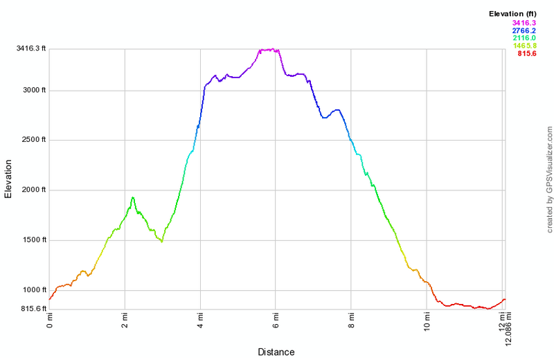
(The image shows the profile of the hike. Remember that all vertical profiles are relative!)
North Lake South Lake:
North Point, Stoppel Point, Escarpment Trail, Palenville Lookout
| Quick Look | |||
|---|---|---|---|
| Difficulty | Round trip | Total climb | Internet Maps |
| 14.4 mi. | 3000 ft. | AllTrails | |
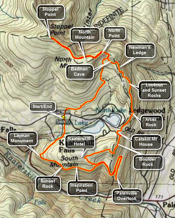 The hiking trails around the North Lake South Lake Campgrounds may be the most scenic in the Catskills.
As you hike the Escarpment Trail the history and the views just seem to get better with every passing
mile. Many spots have names like Inspiration Point and Artist's Rock. Even places that aren't
named have beautiful views of the Hudson River and surrounding countryside.
The hiking trails around the North Lake South Lake Campgrounds may be the most scenic in the Catskills.
As you hike the Escarpment Trail the history and the views just seem to get better with every passing
mile. Many spots have names like Inspiration Point and Artist's Rock. Even places that aren't
named have beautiful views of the Hudson River and surrounding countryside.
Turn north on Rt 18 from Rt 23A in the town of Haines Falls. After about 1 mile, turn right on Schutt Road just before the entrance to the state campgrounds. Turn left into the parking area. Walk up Schutt Road and cross the main road to the campgrounds to the start of the yellow Rock Shelter trail. This may be one of my least favorite trails since it winds its way over rocks and roots for about 1.3 miles to the red Mary Glen Trail. There isn't much to see along the trail. Turn left on the Mary's Glen trail toward North Point. This trail ascends for about .8 miles to join the blue Escarpment Trail near North Point. The hike to the Point is only .3 miles but some of it is very steep with some rock scrambles. Once on North Point you will know that your work was worth it. From this high point you can see spectacular views of the Hudson River and the surrounding communities. North Point has at least three different "levels" and the best view may be from the highest one. Stay on the Escarpment Trail as it levels off slightly and passes by North Mountain. The trail rolls some before climbing to Stoppel Point after about 1.8 miles. Stopple Point offers great views to the northeast and on a clear day buildings in Albany are visible. Continue on for less than a mile to a plane crash on the right side of the trail and watch for another lookout to the south on the right side of the trail as you return. From Stopple Point reverse your path and return 1.8 miles to North Point and the .3 miles back to the junction with Mary's Glen Trail.
This time stay on the Escarpment Trail and in about .7 miles descend a rock slope to the trail junction with the Rock Shelter trail. On your right will be Badman cave which is more of a rock overhang than a cave. Stay on the Escarpment trail by bearing to the left and pass by a small swampy area on the right of the trail. In about .5 miles you will be at Newman's Ledge which offers now limited views. From Newman's Ledge the trail descends steeply for a bit. Watch for a yellow spur trail to the right which leads to Lookout Point and Sunset Rock North. The views of the two lakes from Sunset Rock are beautiful! Lookout Point offers more views of the Hudson to the east. This area also offers an opportunity to climb to the area without using the trail. Several chimneys and cracks provide short but challenging climbs. Return to the main trail and pass under several rock overhangs along the base of the lookouts you just visited. In .5 miles you will be at Artist Rock. This viewpoint offers spectacular views of the Hudson Valley and is often used by photographers and artists. The trail continues to descend to the beach and parking area at the extreme east end of North Lake. Go through the parking lot and head toward the iron gate to stay on the Escarpment Trail and ascend the .25 miles to the site of the former Catskill Mountain House where a large boarding house once stood overlooking the Hudson. There is now an open field and a sign commemorating the structure. The views are fantastic and many people like to picnic here or just sit and enjoy the views. It is easy to see why this was such a popular Catskill destination with a cog railway and road for carriages.
In about .5 miles the Escarpment trail bears left to go toward Boulder Rock and Split Rock. DO NOT take the red cutoff trail or you will miss these two sights. Boulder Rock is a large boulder just sitting on a rocky shelf. This site gives one of the best views of the Hudson River. At Split Rock the trail passes by several places where large pieces of rock have split of the main bedrock formation. Continue on for about .7 miles to the junction with the Schutt road trail near the site of the former Kaaterskill Hotel. This was another popular hotel and boarding house that once stood in the area. Turn sharply left to descend on the Escarpment Trail for about .4 miles. Here the Escarpment Trail meets the Harding Road Trail and a horse trail. Turn left on the Harding Road and horse trail to start the hike to the Palenville Lookout. When the Harding Road Trail turns right DO NOT follow it but stay on the horse trail. There will be few marking on the horse trail so follow it carefully. When the trail splits follow the fork to the right. The trail is flat is places and then descends. It starts out heading northeast but then bends southeast before turning northeast again! After .8 miles, there is a switchback that sends you southwest and descends VERY STEEPLY. At the base of this switchback the trail splits. Make a SHARP RIGHT here to head toward the Palenville Lookout! In another .5 miles you will descend again to the Lookout. The views from here are phenomenal. To the right you can see Kaaterskill High Peak and Round top and up into Kaaterskill Clove. Straight out from the lookout is the Hudson while looking left gives you a view more toward the north. Laid out below, so close you could almost reach out and touch it, is the small town of Palenville. Hikers have used some of the local flagstones to build several chairs on the lookout. A few informal paths lead northeast along the escarpment but none have better views that right at the lookout. Retrace your steps for about 1.3 miles back to the Escarpment Trail.
After walking along the path bounded by laurel for about .8 miles you will be at Inspiration Point with a further .2 miles putting you at Sunset Rock South. Both of these viewpoint offer great views across Kaaterskill Clove and down into the clove itself. The high Peak and Round Top are right across from these lookouts. The houses of Twilight Park seems to had on the edge of the mountain. From Sunset Rock the trail starts to descend for about .5 miles with some descents being steep. The trail then turn sharply right to head back to the Schutt Road lot. At this bend is a stone monument with a plaque commemorating the death of a firefighter who was killed fighting a fire in the early 20th century. From the Layman Memorial the trail ascends and then flattens. It passes by several side trail. Stay on the Escarpment Trail for 1.2 miles and cross Schutt Road to get back to the car. This 15 mile hike is long (obviously) with several challenging ascent and descents. However, once you have done this hike there isn't much around North South Lake that you have missed!
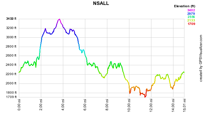 (The image at the left shows the profile of the hike. Remember that all vertical profiles are
relative!)
(The image at the left shows the profile of the hike. Remember that all vertical profiles are
relative!)
North South Lake: Palenville Lookout (Sleepy Hollow)
| Quick Look | |||
|---|---|---|---|
| Difficulty | Round trip | Total climb | Internet Maps |
| 8.8 mi. | 2007 ft. | AllTrails | |
 The hiking trails around the North Lake South Lake Campgrounds may be the most scenic in the Catskills.
As you hike the Escarpment Trail the history and the views just seem to get better with every passing
mile. Many spots have names like Inspiration Point and Artist's Rock. Even places that aren't
named have beautiful views of the Hudson River and surrounding countryside.
The hiking trails around the North Lake South Lake Campgrounds may be the most scenic in the Catskills.
As you hike the Escarpment Trail the history and the views just seem to get better with every passing
mile. Many spots have names like Inspiration Point and Artist's Rock. Even places that aren't
named have beautiful views of the Hudson River and surrounding countryside.
This hike requires two cars for a car shuttle or you will have to double the mileage! Turn north on White Road just west of Palenville on Route 23A. Bear left and park one car in the parking area. Drive back down White Road to Route 23A and turn left. Take the next left on Bogart Road Drive to the junction with Mountain House road and turn left. Drive to the gate and park on the side of the road but DO NOT block the gate. Get on the wide woods road that leads up to the escarpment. The first 1 mile of the hike parallels Stony Brook and there are numerous falls and rapids along the way. Many of these falls are on private property. At 1 mile the trail turns to the left and crosses Stony Brook on a bridge. At this point there is a rock upstream from the bridge that, in the Legend of Sleepy Hollow, was Rip Van Winkle's resting place. This was also the site of the Rip Van Winkle house. The trail now heads generally south with one large switchback as it continues its ascent for the next 1.9 miles. Watch to your left along the way for several nice viewpoints. At 3.3 miles the trail crosses of right-of-way which was originally cut for the Otis Elevating Railway. The railway hauled passengers from the valley to the Catskill Mountain House. This area of the trail is often VERY wet. At 3.8 miles there is a trail junction and you should continue straight ahead to go to the Palenville Lookout which is about a .5 mile walk. At the main part of the lookout there is the remains of a foundation and some stone furniture that hikers have constructed. The view from here is outstanding particularly on a clear day. Palenville is just below but you can see out to the Hudson and beyond. You may walk along the escarpment to the left for some additional views. When you are ready, walk back up the trail and turn on the path to the left that takes you out to another lookout. This viewpoint better allows you to look back up Kaaterskill Clove. Back on the main trail walk to the trail junction, turn left and get ready for a short but steep ascent that approaches a 30% grade! The horse trail will continue to climb for the next .85 miles to a trail junction. Turn left on Harding Road. This road was constructed to bring materials to the plateau to build the Kaaterskill Hotel owned by George Harding. This road props 00 feet over the next 2.4 Niles and has several switchbacks that were needed to allow horse drawn wagons to make the grade. Watch to your right along the way for viewpoints. There is at least one stream crossing but you will not get your feet wet. At the end of the road a short trail takes you the additional .5 miles to the parking area.
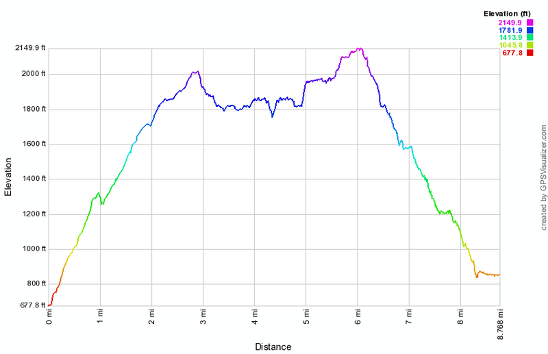 (The image at the left shows the profile of the hike. Remember that all vertical profiles are relative!)
Whites Road to Malden Avenue
| Quick Look | |||
|---|---|---|---|
| Difficulty | Round trip | Total climb | Internet Maps |
| 2.5 mi. | 366 ft. | ||
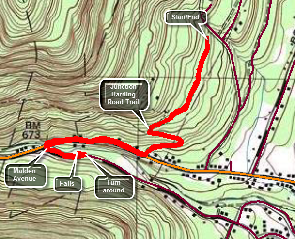 The hiking trails around the North Lake South Lake Campgrounds may be the most scenic in the Catskills. As you hike the Escarpment Trail the history and the views just seem to get better with every passing mile. Many spots have names like Inspiration Point and Artist's Rock. Even places that aren't named have beautiful views of the Hudson River and surrounding countryside.
This hike "connects" the Harding Road Trail to Malden Avenue to complete a section of the Long Path. Turn north on Whites Road just west of Palenville on Route 23A. Drive up the road a little more than half a mile watching for the access road to the parking area on the left. Park in the small lot and head out on the yellow connector trail. The first .4 miles of trail are relatively flat but then the trail begins to lose some elevation to the junction with the red-blazed Harding Road Trail. Turn left and drop some more elevation to the end of the Harding Road Trail at Route 23A. There is a small parking area here with a sign board. Turned right on Route 23A and began to hike to Malden Avenue. The shoulders on Route 23A are very narrow and it can be a little tricky when there is traffic coming down the hill. It is only .35 miles to the turn and at 1 mile turn left on Malden Avenue. You may turn around here or hike down Malden Avenue for some distance. There is a falls on the creek just downstream from the bridge. The land between the trail and the falls is private property so you will have to use the zoom on your camera to take pictures. When you are done, turn around and walk back to the Harding Road Trail. As you ascend the trail, be sure to make the turn on the yellow connector trail. Almost immediately after that turn the yellow trail heads to the right and an unmarked woods road continues straight ahead and up the hill. Be sure to stay on the yellow trail.
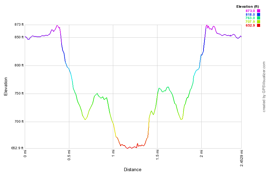 (The image at the left shows the profile of the hike. Remember that all vertical profiles are relative!)
Kaaterskill High Peak (Palenville)
| Quick Look | |||
|---|---|---|---|
| Difficulty | Round trip | Total climb | Internet Maps |
| 10.5 mi. | 4420 ft. | AllTrails | |
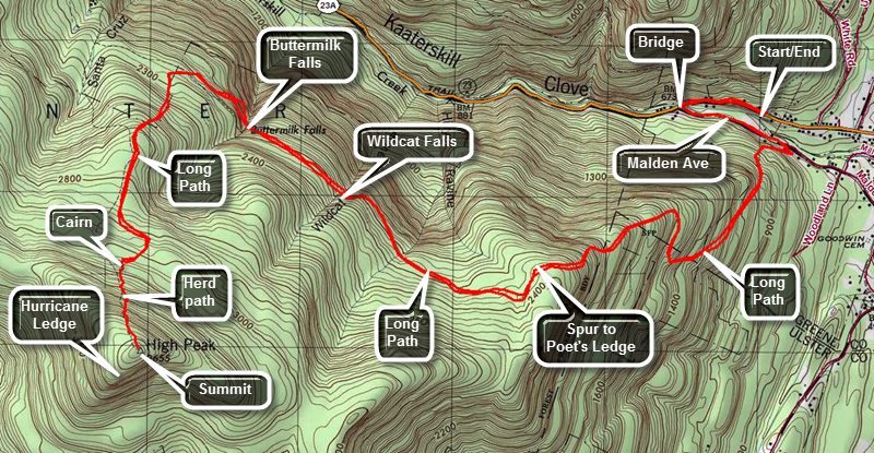
Take Route 23A from Palenville toward Haines Falls if you are coming from the east or from Haines Falls to Palenville if coming from the west. Park on the north side of 23A near Palenville near where the road cross Kaaterskill Creek. Walk on the road and cross over to a "street" that branches off just before 23A crosses the creek. Watch for the aqua blazes of the Long Path and blue hiking disks. This street is now blocked and closed to traffic. It has been overgrown with vegetation and only the paved surface here and there separates it from any other trail. On the other end of this short path you will be back on paved road. The blazes will continue for a short distance and the direct you to turn up a short street/driveway. Blue markers now appear in addition to the blaze. After a few feet, the trail turns onto a woods road and into the forest.
The path ascends on the wood road, leveling at times, but always continuing upward. After less than a mile, the trail again cuts right and starts serious climb up! The trail has several switchbacks and there are hints of views to the right. Continue on this trail which levels at times and then becomes much steeper. In about 1.25 miles there is an obvious lookout to the right. The lookout gives a glimpse of the Clove below and the mountains to the north. Continue on the main path for another half mile. At this point a sign points to a yellow spur trail that DESCENDS to Poet's Ledge. The descent is worth it since the view is very nice. As you descend you will pass a large, flat expanse of rock with several fire circles. There is a view from here but this is NOT Poet's Ledge. After another short descent through some rocks you will be on the Ledge.
The Ledge gives an unobstructed view of Kaaterskill Clove and Route 23A below. To the left is South Mountain and the Escarpment Trail. On the right looming above the Ledge is Kaaterskill High Peak. The Ledge is at 2200 feet but the mountain is another 1400 feet of vertical gain. After visiting Poet's Ledge and returning to the main trail turn right and continue toward Hillyer, Wildcat and Buttermilk Falls. Each of these is more impressive than the next. How impressive they all are depends on the volume of water flowing over them. Each offers a glimpse of the other side of the clove. In fact, this entire part of the trail is relatively flat and there always seems to be an elusive glimpse of the clove off to your right.
After the last falls the trail turns to the southwest and begins to ascend. Some of these ascents are steep and over rocky areas. The trail cuts back and forth to make the climb easier. In a short distance the trail turns 90 degrees and heads southeast. Be VERY careful to look for a sign that points to a snowmobile trail that turns right off this path. Hike up the trail to the snowmobile trail that loops around Kaaterskill High Peak and Round Top Mountain. Turn right on the loop trail. In just a little while you will see a WELL-DEFINED herd path marked with a stone cairn on your left. Get ready for a short but steep climb up to the High Peak. Unfortunately, there is NO VIEW from the top. Views may be had by walking toward the east or south. Many of these views have been blocked as trees grow taller every year. Turn around a retrace your steps to the car.
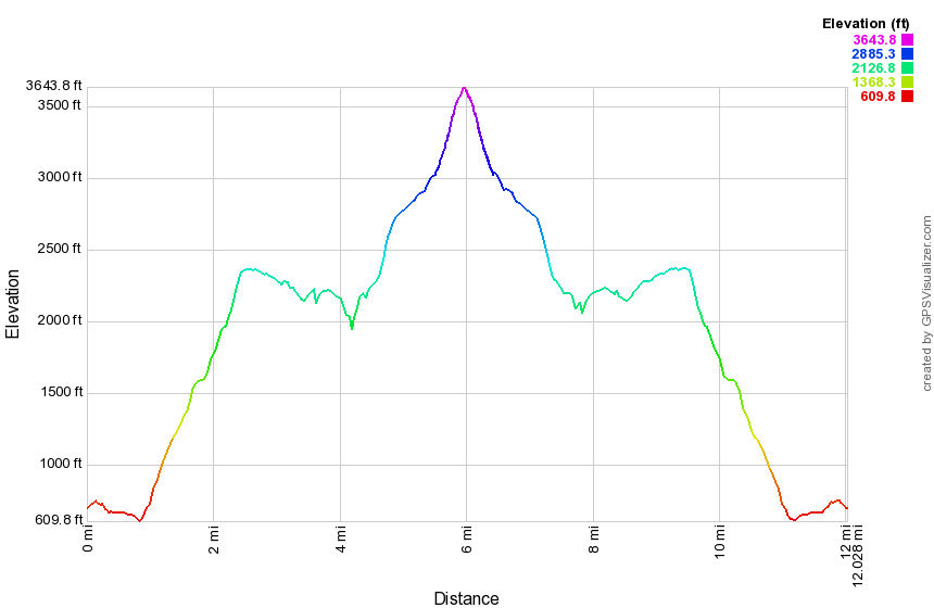
(The image at the left is the vertical profile for the out and back hike so it has a symmetrical appearance. )
Kaaterskill High Peak (Platte Clove)
| Quick Look | |||
|---|---|---|---|
| Difficulty | Round trip | Total climb | Internet Maps |
| 7.2 mi. | 1785 ft. | ||
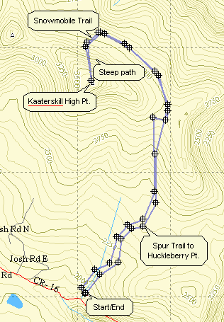
Turn onto Bloomer Rd. off Route 23A just west of Tannersville. At the Y in the road bear left onto
Platte Clove Rd. Continue on this road passed the Catskill Bruderhof and pull into the parking lot for
Kaaterskill High Peak. Look for the aqua-blazed Long Path. Follow this trail for 1.05 miles where the
Huckleberry Point trail goes off to the right. Stay on the Long Path as it winds its way up the mountain
for another 2.1 miles. This route goes around to the north side of the mountain where a very obvious
path leads up to the loop snowmobile trail that goes around the peak. Make a right on the snowmobile trail
and look for a well-traveled path to the left. This will take you the .5 miles to the top. At the very
summit of the High Peak (3655 ft.) there is no view. If you walk off to the east or south views open up
in both directions. To return to the parking area retrace your route. There are several ways to cut the
distance to the High Peak by bushwhacking but they don't really cut the time needed to scale the peak.
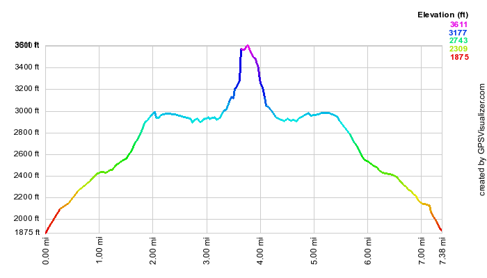
(The image above is the vertical profile for entire hike so it has a symmetrical appearance. Much of the trail is a level area near the summit that takes you around to the north side of the mountain. The distance makes the final climb to the peak look gentle. This is one of the steepest climbs in the Catskills over an unmaintained trail.)
Platte Clove to Kaaterskill Parking
| Quick Look | |||
|---|---|---|---|
| Difficulty | Round trip | Total climb | Internet Maps |
| 1.0 mi. | 325 ft. | AllTrails | |
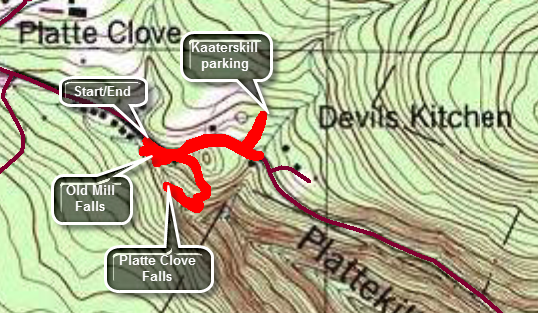
This hike connects the section of the Long Path that comes over Kaaterskill from Palenville with the section that goes through the Platte Clove Preserve and over the Devil's Path. It includes a hike to the two falls in the Preserve.
Turn onto Bloomer Rd. off Route 23A just west of Tannersville. At the Y in the road bear left onto Platte Clove Rd. Continue on this road passed the Catskill Bruderhof and pull over to park by the Platte Clove Preserve. Begin the hike by walking along the road for about .2 miles to the access road for the parking area for Kaaterskill High Peak. Walk up the access road to the register box and then turn around and walk back to the Platte Clove Preserve. Before returning to your car, turn left and walk passed the front of the cabin and down to Platte Clove Falls. Walk back up the trail after your visit to the falls and take one of the informal paths to the right of the cabin and follow it down to the stream. There is a rock outcropping in the stream that makes a nice spot to take pictures of Old Mill Falls and the kingpost bridge that crosses the stream just above the falls.
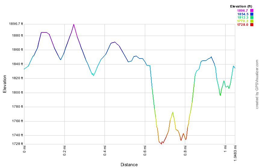
(The image above is the vertical profile for entire hike.)
Indian Head and Twin (Platte Clove)
| Quick Look | |||
|---|---|---|---|
| Difficulty | Round trip | Total climb | Internet Maps |
| 7.6 mi. | 2186 ft. | AllTrails | |
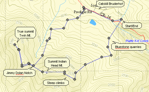
Turn onto Bloomer Rd. off Route 23A just west of Tannersville. At the Y in the road bear left onto Platte Clove Rd. Continue on this road passed the Catskill Bruderhof and pull into the parking Lot for Kaaterskill High Peak. Walk back down the access road and take a right on Platte Clove Rd. Walk a short distance to the Platte Clove Preserve owned by the Catskill Center. Get on the aqua-blazed trail which is part of the Long Path. Follow this for .95 miles to the junction with the Overlook Trail and the Devil's Path. Turn right on the red-blazed Devil's Path. Ascend 1.25 miles through some steep areas to a lookout to the north. From here you can see the profile of Kaaterskill High Peak and a view of the Bruin. Continue on the trail for another .5 miles and get the view from another spectacular lookout. The peak of Indian Head Mountain (3573 ft.) is another .65 miles ahead. At this point you can retrace your route or continue down the other side to Jimmy Dolan Notch. At the notch you can turn back to the parking area or climb Twin Mountain. The best choice is to do Twin while you are there.
Follow the Devil's Path for .4 miles until you arrive at Jimmy Dolan Notch. Continue straight ahead
and up. The east summit of Twin Mountain is .4 miles ahead. At this point you will walk out onto a flat
rock prominence which gives a wonderful view of the valley below and includes Indian Head, Sugarloaf
and Plateau Mountains. In another .7 miles you will be at the summit of Twin Mountain (3640 ft.) Take
in the view an then turn around an return the 1.5 miles to Jimmy Dolan Notch. Now turn left on the
blue-blazed Jimmy Dolan Notch Trail and walk 1.2 miles downhill to an old logging road. In another
.4 miles, after you walk through the new parking area, you will be at the end of Prediger Road. Walk .2 miles to the end of Prediger Road
and turn right on Platte Clove Rd. Walk about 1 mile passed the Catskill Bruderhof and back to the
parking area.
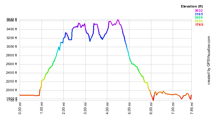
(The image is the vertical profile for the hike. Don't be fooled by the gentle curves. Some of the ascents and descents are very challenging. The symmetrical peaks on the right show the out and back of the trip to Twin Mountain.)
Plateau, Sugarloaf, Twin (Roaring Kill)
| Quick Look | |||
|---|---|---|---|
| Difficulty | Round trip | Total climb | Internet Maps |
| 8.55 mi. | 4325 ft. | AllTrails | |
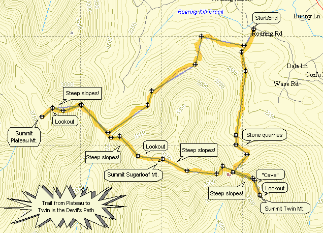 In Tannersville take Bloomer Road which is on the Hunter side of town. Continue on Bloomer until the
junction with Platte Clove Rd. Bear right here onto Elka Park Rd. Follow the signs to the trail head. The
road deteriorates quickly to dirt and the parking is limited. Take the yellow-blazed Roaring Kill trail
from the parking area. After only .25 miles this trail branches left to Pecoy Notch and right to the
Mink Hollow Trail. Turn right. The trail ascends gently through hardwood forests and, at times, over rock strewn areas.
It rolls some with a few ups and downs along the way. In more than one spot hikers have walked off the trail to get a
view or collect wood. Watch carefully that you stay on the main trail. In several spot there are views of Plateau
Mountain rising on your right. The mountain in quite impressive and this gives you some idea of the climb to come! One
lookout is especially nice and allows you to take pictures before a slight descent. Continue for about 2.5 miles to the
junction with the red-blazed Devil's Path.
In Tannersville take Bloomer Road which is on the Hunter side of town. Continue on Bloomer until the
junction with Platte Clove Rd. Bear right here onto Elka Park Rd. Follow the signs to the trail head. The
road deteriorates quickly to dirt and the parking is limited. Take the yellow-blazed Roaring Kill trail
from the parking area. After only .25 miles this trail branches left to Pecoy Notch and right to the
Mink Hollow Trail. Turn right. The trail ascends gently through hardwood forests and, at times, over rock strewn areas.
It rolls some with a few ups and downs along the way. In more than one spot hikers have walked off the trail to get a
view or collect wood. Watch carefully that you stay on the main trail. In several spot there are views of Plateau
Mountain rising on your right. The mountain in quite impressive and this gives you some idea of the climb to come! One
lookout is especially nice and allows you to take pictures before a slight descent. Continue for about 2.5 miles to the
junction with the red-blazed Devil's Path.
Turn right on the Devil's Path and be prepared for a long, hard climb up to Plateau. Continue for 1 mile and 1200 feet of vertical climb to the lookout near the summit of Plateau. The climb is strenuous with near vertical parts in places. Most of the trail has switchbacks to soften the ascent somewhat. Proceed onward for another .2 miles to the highest point on Plateau. There is little to see from this spot but it is the highest point on the mountain. Retrace your steps to the rock which allows a fine view of Sugarloaf Mountain in front of your and other peaks to the right and left. return to the parking area. When you have rested briefly, retrace your steps to the Mink Hollow trail and get ready for the ascent up Sugarloaf.
The ascent of the Devil's Path up Sugarloaf will remind you a lot of the ascent up Plateau. The vertical gain of 1200 feet is almost identical and the hiking distance is about the same. One mile and 1200 feet may not sound too impressive but the climb itself is quite a challenge made all the more challenging by your recent climb up Plateau. As you ascend and get near the top of the climb a large boulder acts as a lookout to Plateau and the other surrounding peaks and the valley below. This is even more open than the one on Plateau and so the view is better. Once you get to the summit of Sugarloaf there isn't much to see so continue on the Devil's Path toward Twin.
The Devil's Path leads down Sugarloaf and in about 1.2 miles you will be at Pecoy Notch. From here you can turn left on the Pecoy Notch trail and go back to the parking area. Since you are looking for more of a challenge, continue straight ahead on the Devil's Path. The distance is ONLY about .7 miles and the vertical gain is ONLY about 800 feet since Twin has the lowest elevation of the three mountains. These facts belie the difficulty that awaits. This short climb is one of the most challenging in the Catskills. The trail becomes steep almost immediately with several areas of open rock face to negotiate. In several other areas the trail seems to end until you look UP to see a marker almost directly above. These near vertical areas require some leg strength and upper body strength to push and pull your way up. Some views are available as you look over your shoulder back at Sugarloaf but you will be busy climbing and there are better views at the top.
Near the summit of the western peak of Twin the trail flattens and provides some relief from the difficult climb. In this area is a "cave" made by an overhanging rock ledge. Next to the cave the trail continues through a narrow passage which requires a good toehold and handhold to push and pull yourself up. The trail winds briefly and then reaches the summit on an open expanse of rock. This lookout provides GREAT views back to Sugarloaf and Pecoy Notch. In fact the view is very open for a 180 degree or more view of the entire area. The east peak of win is visible and Indian Head can be seen if you walk out onto the ledge. After taking some pictures and relaxing a little retrace your steps back down to Pecoy Notch. The way down is easier than up but still requires great care.
At the junction with the Pecoy Notch trail turn right to get back to the parking area. The trail starts as a scramble
over many rocks but softens as you move father down. In about .4 miles is a beaver pond on the left which offers views
back to Sugarloaf and Twin. In another .5 miles you arrive at Dibble's Quarry. here hikers have crate oversized chairs
out of the discarded bluestone that litters the area. This open area provides unobstructed views of Roundtop,
Kaaterskill High Peak and parts of the Hudson Valley. In .7 miles the trail ends at the Roaring Kill Trail. The parking
area is only .25 miles away!
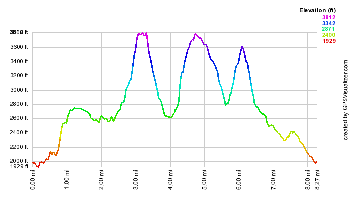
(The image is the vertical profile for the route up to the summit.)
Plateau (Notch Inn Road)
| Quick Look | |||
|---|---|---|---|
| Difficulty | Round trip | Total climb | Internet Maps |
| 8.2 mi. | 2560 ft. | AllTrails | |
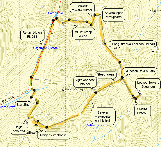 Turn onto Notch Inn Road just south of the Devil's Tombstone Campgrounds on Green County Route 214. On some maps and GPS this may be marked as Silver Notch Road. Once you turn on the road continue to drive until the road begins to level off. You will see "Privately Maintained" signs at some point. Park in one of the pulloffs along the road BEFORE these signs. If you want to park at the small parking area at the dead end, make sure you get permission from the owner of the house at the end of the road. Be sure NOT to block the driveway of any of the private homes on the road. Start walking on the woods road following the aqua blazes of the Long Path. The new trail actually relocates and eliminates this section on the Long Path so many of the blazes may be painted over. After about .5 miles, look for the sign for the new blue-blazed trail on your left. Turn here and follow this trail to the Devil's Path.
The trail continues for about 1.3 miles climbing unnamed mountain to almost 3400 feet! This includes many switchbacks to moderate the climb. There area a few places to get a view but most are blocked by vegetation in the spring and summer. After the top of this mountain, there is a descent of about .5 miles into a Col before the final assault on Plateau. The climb is almost 500 feet in .5 miles. Near the top the trail levels so the steep spots before that can be very steep. There are several nice viewpoints and lookouts along the way. At the top the trail meets the Devil's Path as the long Path turns left at this point.
There are several options now available. One is to turn around and go back directly. Another is to turn right and hike the .5 miles to the summit and an extra .1 miles to the rock that gives a great view of Sugarloaf and the surrounding mountains and valleys. You can then reverse your course. The option shown on the map is to turn around from the Sugarloaf lookout and continue following the Devil's Path down to Notch Lake. From Notch Lake walk south on Route 214 to Notch Inn Road and back to your car. This option offers a loop and a nice view of Hunter Mountain and Stony Clove. The descent to Notch Lake is STEEP but manageable. The walk back on 214 goes quickly as it is downhill.
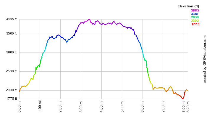
(The image is the vertical profile for the route up to the summit.)
Silver Hollow (Notch Inn Road)
| Quick Look - Silver Hollow | |||
|---|---|---|---|
| Difficulty | Round trip | Total climb | Internet Maps |
| 3.5 mi. | 1150 ft. | AllTrails | |
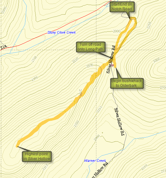
Silver Hollow is one of the CHH peaks that IS on public land and has a trail to the highest point. In fact, the trail is the Long Path. The trailhead is at the end of Notch Road off Route 214 north of Phoenecia and south of Hunter. Once you turn on the road continue to drive until the road begins to level off. You will see "Privately Maintained" signs at some point. Park in one of the pulloffs along the road BEFORE these signs. If you want to park at the small parking area at the dead end, make sure you get permission from the owner of the house at the end of the road. Be sure NOT to block the driveway of any of the private homes on the road. The first part of the trail heads up an old woods road which is highly eroded in places and may resemble a cross between a rock scramble and a stream. The trail has been routed around the worst of these areas. This trail was once part of the Long Path but the new Warner Creek Trail over Plateau has eliminated the need for a road walk along 214.
After about .5 miles turn right off the road onto the Long Path marked with aqua blazes. This trail also goes left and ascends to the Devil's Path on Plateau. The next .5 miles or so are a gradual climb up to the summit plateau of Silver Hollow. Once on the flat part at the top, the trail wanders back and forth but stays near the edge of the ridge. There are some views of Little Rocky (not the CHH peak) and Olderbark which are better when there is less vegetation on the trees. After around .5 miles, you will have crossed several "higher" spots of land any of which may be the highest spot on the ridge. I walked until I started to descend and the returned the way I came. Back on the road I started a bushwhack toward Olderbark but decided that since I could not get any visual I would try that peak from another trailhead.
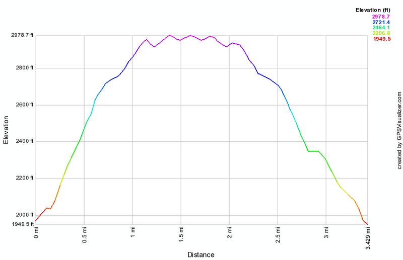
(The image at the left is the vertical profile for the entire out and back hike.)
Willow Trail to Silver Hollow
| Quick Look | |||
|---|---|---|---|
| Difficulty | Round trip | Total climb | Internet Maps |
| 11.5 mi | 4880 ft | AllTrails | |
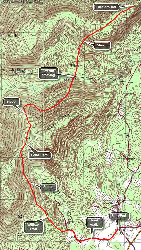 Turn off Route 28 onto the main street in Phoenicia. Continue on Main Street which becomes Route 40 and passes the main parking area for Mount Tremper. At the intersection with Route 212 turn left and drive to VanWagner Road on the left. Turned left on VanWagner Road to get to the small hamlet of Willow. Along the way you will pass the Woodstock Farm Animal Sanctuary on the left. Just passed this is the intersection with Jessup Road which leads to the Willow Trail. On the corner is the Willow Post Office where you will park since there is no parking near the actual trailhead. The post office appears to be a construction trailer with a zip code sign! To begin your hike walk up Jessup Road for about 1.1 miles passing the end of the public road along the way. Turn left onto the woods road that is the first part of the trail. The trail climbs from the post office but after the turn into the woods it begins to ascend more steeply. The grade averages about 15% until it levels off at 2 miles. Along the way the route transitions from the woods road to a trail that, in some cases, hangs right on the edge of the hill. It becomes rocky and the footing can be difficult especially in wet weather. At the two mile mark the trail elevation has increased from about 1100 feet to almost 2100 feet. Along the way you may get some views of the mountains and valleys to the north and east. After a quarter mile of relatively flat walking, the trail again begins to ascend gaining another 400 feet to the trail junction with the Warner Creek Trail at 2.7 miles. At the trail junction turn right to follow the Warner Creek Trail north toward Carl Mountain. At about 2.8 miles the trail begins to drop some as it negotiates a route that does not actually reach the summit of Carl Mountain. The trail descends off the slopes of Carl Mountain until at 4.25 miles it crosses Warner Creek. This can be a tricky crossing when the water is high. Continue on the trail as it begin an ascent up to the ridge. This ascent can be steep at times as it gains 1400 feet in less than a mile. Once the ascent is complete walk along the flat summit of Silver Notch until you are ready to turn around. To complete the out and back hike simply turn around and follow your route back to the car.
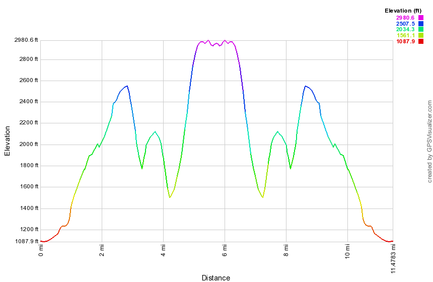
(The image shows the profile of the hike. Remember that all vertical profiles are relative!)
Willow Trail to Mount Tremper
| Quick Look | |||
|---|---|---|---|
| Difficulty | Round trip | Total climb | Internet Maps |
| 9.5 mi | 2310 ft | AllTrails | |
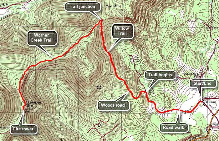 Turn off Route 28 onto the main street in Phoenicia. Continue on Main Street which becomes Route 40 and passes the main parking area for Mount Tremper. At the intersection with Route 212 turn left and drive to VanWagner Road on the left. Turned left on VanWagner Road to get to the small hamlet of Willow. Along the way you will pass the Woodstock Farm Animal Sanctuary on the left. Just passed this is the intersection with Jessup Road which leads to the Willow Trail. On the corner is the Willow Post Office where you will park since there is no parking near the actual trailhead. The post office appears to be a construction trailer with a zip code sign! To begin your hike walk up Jessup Road for about 1.1 miles passing the end of the public road along the way. Turn left onto the woods road that is the first part of the trail. The trail climbs from the post office but after the turn into the woods it begins to ascend more steeply. The grade averages about 15% until it levels off at 2 miles. Along the way the route transitions from the woods road to a trail that, in some cases, hangs right on the edge of the hill. It becomes rocky and the footing can be difficult especially in wet weather. At the two mile mark the trail elevation has increased from about 1100 feet to almost 2100 feet. Along the way you may get some views of the mountains and valleys to the north and east. After a quarter mile of relatively flat walking, the trail again begins to ascend gaining another 400 feet to the trail junction with the Warner Creek Trail at 2.7 miles. At the trail junction turn left to follow the Warner Creek Trail to Mount Tremper where it ends at the fire tower. The turn is more than 90 degrees and changes the direction of travel from north to west by southwest. Initially the trail ascends some but at 3.2 miles it starts a descent to avoid sidehilling along an unnamed bump before Mount Tremper. At 4 miles another climb begins as the trail turns south and heads toward the fire tower. Over the next .85 miles you will reach a sort of summit plateau and negotiate a short descent before climbing again to reach the tower. The last ascent is about 365 feet. The Warner Creek Trail ends at the tower. To complete the out and back hike simply turn around and follow your route back to the car.
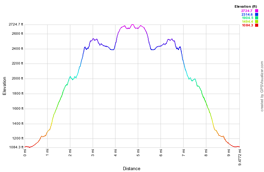 (The image shows the profile of the hike. Remember that all vertical profiles are relative!)
Tremper Mountain: Rt. 40, Phoenicia
| Quick Look | |||
|---|---|---|---|
| Difficulty | Round trip | Total climb | Internet Maps |
| 6.1 mi. | 2100 ft. | AllTrails | |
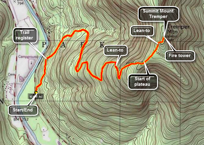 The Tremper Mountain Fire Tower is believed to be the oldest of the reconstructed fire towers in
The Catskills. It was originally constructed elsewhere in 1917 and then moved to its present location.
The trail is mostly along an old road to the summit. It has many switchbacks which make the route
Not as steep as it might be but also add length to the distance. Views of the surrounding mountains
are easily has had from the fire tower.
The Tremper Mountain Fire Tower is believed to be the oldest of the reconstructed fire towers in
The Catskills. It was originally constructed elsewhere in 1917 and then moved to its present location.
The trail is mostly along an old road to the summit. It has many switchbacks which make the route
Not as steep as it might be but also add length to the distance. Views of the surrounding mountains
are easily has had from the fire tower.
From Rt. 28 turn at the sign that indicates the village of Phoenicia. Continue straight through town until the sign for Rt. 40. Continue of Rt. 40 for about 3/4 of a mile. Pass the first parking area on your right. Park at the next parking area on the left. This area has a sign for the Tremper Mountain Fire Tower. Walk over three bridges and up a hill on the stone steps. Don't be surprised at the lack of a trail register at this point. The register is a little over a quarter mile on the trail. From here follow the well-marked red Phoenicia trail to the tower. The trail is an old road to the tower. It has many switchbacks which makes the incline quiet easy but lengthens the hike. It is possible to cut some of the switchbacks or bushwhack the entire way. BE CAREFUL! There are reports of timber rattlesnakes in this area!
The trail eventually reaches a plateau and after a short hike and a short climb you will be at the fire tower. This tower is surrounded by trees until you get near the top. The views are nice but not as interesting as the ones from Overlook, Balsam or Hunter on a nice day. Retrace your trail and you will be back at your car.
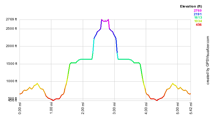 (The image at the left shows the profile of the hike. Remember that all vertical profiles are
relative!)
(The image at the left shows the profile of the hike. Remember that all vertical profiles are
relative!)
Tremper Mountain to Lane Street
| Quick Look | |||
|---|---|---|---|
| Difficulty | Round trip | Total climb | Internet Maps |
| 4.8 mi. | 250 ft. | AllTrails | |
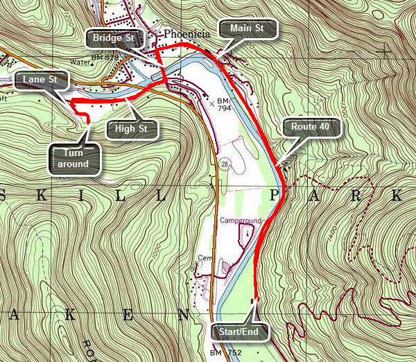 This hike connects the Mount Tremper parking area to the trail over Romer and Cross Mountains that starts at Lane Street in Phoenicia. Turn off Route 28 and drive down the Main Street of Phoenicia which eventually becomes Route 40. Watch for the parking area for Mount Tremper on the right. Park in the lot and hike back toward the village on Route 40. At 1.6 miles turn left on Bridge Street and walked across the Esopus on a road bridge. Just after the bridge turn right on High Street. At 2.2 miles turn left onto Lane Street and walk to the parking area at the end. Turn around and retrace your path back to the parking area.
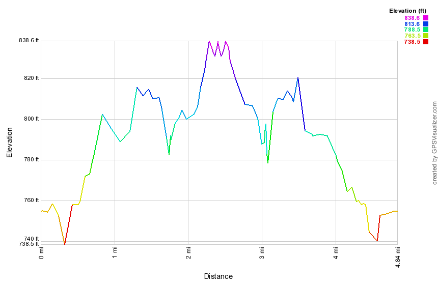 (The image shows the profile of the hike. Remember that all vertical profiles are relative!)
Romer Mt: Long Path from Woodland Valley to Lane Street
| Quick Look | |||
|---|---|---|---|
| Difficulty | Round trip | Total climb | Internet Maps |
| 11.2 mi. | 2805 ft. | AllTrails | |

This hike requires a car spot or a drop off as the one-way distance is 11.2 miles! Turn onto Woodland Valley Road from Route 28 west of Phoenicia . After crossing the bridge over the Esopus Creek turn left on High Street even though there may be no sign. Watch for Lane Street on your right after about .5 miles. Turn right on Lane Street and drive to the end and make a right to cross over a small stream. Park one car in the parking area. Drive back on Woodland valley Road to the Woodland Valley Campgrounds. Park another car in the lot here and pay the parking fee at the booth or have someone drop you at the lot. Walk across the road and through some campsites to find the beginning of the trail on a ridge that crosses a stream. The first mile of trail from the bridge gains 920 feet at an almost 18% grade. The trail continues to ascend for another .75 miles before leveling off some. Once the trail levels off it has only a few ups and downs until the junction with the trail to Terrace Mountain at 2.5 miles. Turn right at this junction and start toward Wittenberg. The new trail is about .2 miles further along the main trail on the left at 2.7 miles. Turn left onto the new trail which has blue markers indicating that it is an extension of the Pine Hill - West Branch Trail. There is also an official Long Path marker as well.The surface of the trail is smooth and flat at the beginning but changes to rocky and back to smooth any number of times. At 3.5 miles you may see a path that leads to the site of the camp the trail crew used when they stayed in the woods to work on the trail! At 3.5 miles descend the first staircase which is very nicely constructed. Remember that the trail crew members were working only with hand tools and the stones and rocks available around them! Walk along the edge of a dropoff and at 3.7 miles you will come upon an open rock face with beautiful views to the north and east. Turn to my left to see the imposing bulk of Wittenberg looking down at you. To the north are the mountains of the Devil's Path. The views are spectacular! Continue on your way down the rock face and descend for the next quarter mile. You are actually still on a ridge and lose only about 250 feet. Watch to your right for possible lookouts. At 4.75 miles you will start to ascend Cross Mountain. There is a limited lookout on the right with some views of the Ashokan Reservoir. A few hundred feet further along there is another, better viewpoint. If you climb a little more and there is a third lookout with the best views of all. Get back on the main trail and continue over the top of Cross Mountain and then down the other side. You will skirt the summit of Mount Pleasant at about 6.5 miles into the hike. There is another great lookout on the left of the trail with an almost 180 degree field of view. Only the view to the north is partially blocked. From the lookout there is a drop of about 600 feet to the 8 mile point where there is a slight climb over an unnamed bump. Once you are over the top of Romer Mountain there is less than 3 miles to the car and it is all downhill. Near the bottom, a series of switchbacks turns a quarter mile hike into almost of mile of trail!
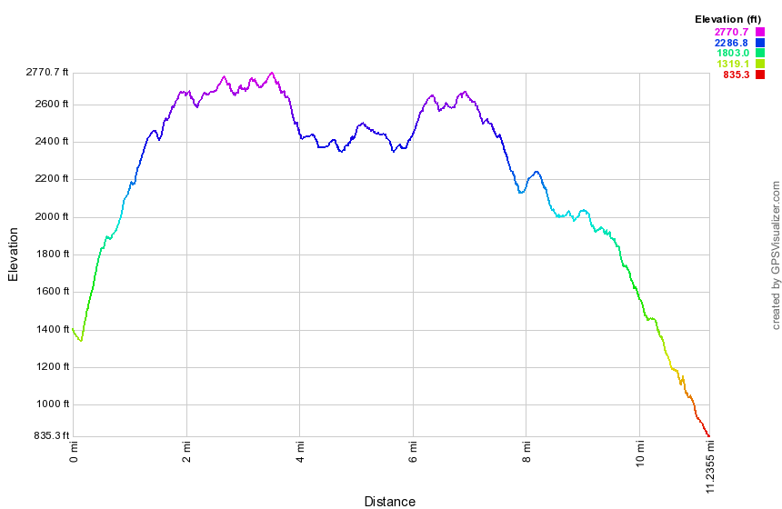
(The image shows the profile of the out and back hike. Remember that all vertical profiles are relative!)
Burroughs Range Out and Back from Woodland Valley
| Quick Look | |||
|---|---|---|---|
| Difficulty | Round trip | Total climb | Internet Maps |
| 13.1 mi. (round trip) | 4767 ft. | AllTrails | |
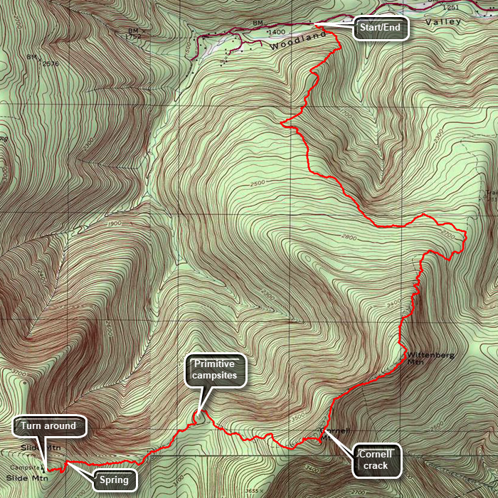
The out-and back trip loop over all three peaks in the Burroughs Range is 13 miles with many challenging rock scrambles. This loop traverses Wittenberg, Cornell and Slide with Cornell and Wittenberg done twice. Many people park one car at each end of the trail which cuts the distance to just over nine miles. Parking is available on RT 47 at the Panther Mountain or Slide Mountain trail head. Parking at Woodland Valley State Campgrounds is also possible but there may be a seasonal parking fee.
From Woodland Valley follow the red markers through the campsites to the bridge over the stream and to the red-blazed trail. Immediately the trail gives you a hint of what is to come. There is an ascent to even get to the log book! After 3.9 miles of ascent including some interesting rock scrambles, you arrive at the top of Wittenberg Mountain. Wittenberg offers one of the finest lookout in the
Catskills and is well worth the effort. The trail now descends into the col between Wittenberg and Cornell and then ascends to the summit of Cornell, a total distance of only .85 miles. Be sure to take
the short spur trail to the left at the top of Cornell to actually reach the highest point on the mountain. The trail now descends to the col between Cornell and Slide which is reached after about 1.4 miles. As you begin the steep climb up Slide, look to the right as you ascend the rock and wood "staircases". A short trail leads to a spring which also affords a nice view back at Cornell. After about .85 miles from the col, you will be at the Slide Mountain lookout. After a rest at the top of Slide, it is time to turn around and start back!
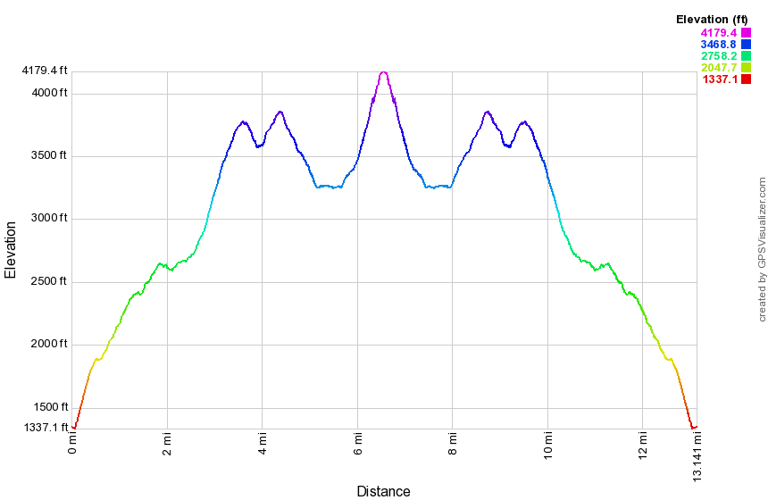
Slide from Denning
| Quick Look (Denning Out and Back) | |||
|---|---|---|---|
| Difficulty | Round trip | Total climb | Internet Maps |
| 10 mi. | 2523 ft. | AllTrails | |
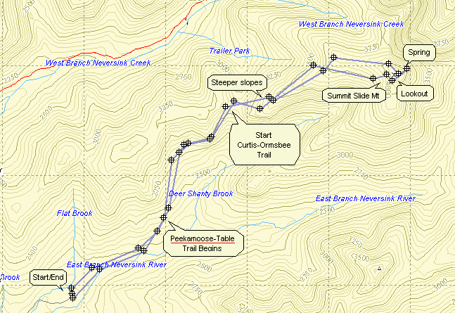
A longer but still easy path starts at the Denning trailhead on the Claryville Road. Park at the trailhead and find the yellow-blazed Phoenicia-East Branch trail. This starts out as a wide logging road and continues for 3 miles. The trail gets rockier, more rugged and steeper until it meets the blue-blazed Curtis-Ormsbee Trail at the Curtis Monument. This trail continues 1.65 miles until it joins the red-blazed Wittenberg Cornell Slide Trail. From this point it is about .7 miles to the summit of Slide and the lookout.
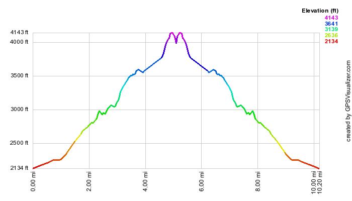
(The image above is the vertical profile for the entire hike which starts and ends at the Denning trail head. It includes a trip to the spring.)
Table and Peekamoose from Denning
| Quick Look - Table and Peekamoose from Denning | |||
|---|---|---|---|
| Difficulty | Round trip | Total climb | Internet Maps |
| 8.4 mi. | 2570 ft. | Google Maps | |
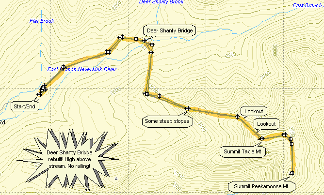
Turn onto County Route 19 (Claryville Road) from State Route 52 in Curry between Neversink and Grahamsville. Stay on the road until the hamlet of Claryville. Continue through Claryville where the name of the road changes to the Denning Road. Stay on this road until you run out of road. Park in the Denning Trail Head lot. Get on the yellow-marked Phoenicia-East Branch Trail and hike for about 1.2 miles. At this point the blue-marked Peekamoose Table Trail turns to the right and heads down to the East Branch of the Neversink River and Deer Shanty Brook. After .3 miles, there will be a log bridge cross the East Branch. This bridge washes out at times and the river may not be easily crossed! The trail now heads toward Table Mountain with several smaller hills to cross before the main ascent. Just after 3000 ft there is a very obvious lookout on the right which has a nice view to the south. After about 2 miles, there is a small spring on the left which can dwindle to nothing in dry weather. In another .1 miles, there is a spur trail to the right that leads to a lean-to. Shortly a sign announces the 3500 ft elevation. Keep your eyes open for another short trail to the right which leads to a small outcropping of rock. This is another lookout facing south. There are several other places on this trail that hint of views both to the south and north but foliage in the summer blocks these views. The hiking gets steep now for the last .2 miles at which time you have arrived at the summit of Table Mountain. The hike to Peekamoose is only .85 miles more and the drop into the Col between them is minimal. Peekamoose doesn't offer many vies but the trail near the top is interesting. After reaching the summit of Peekamoose, retrace your steps back to the parking lot.
(The map shows the out and back hiking route.)
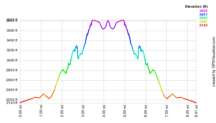
Peekamoose from Peekamoose Road
| Quick Look - Peekamoose from Peekamoose Road | |||
|---|---|---|---|
| Difficulty | Round trip | Total climb | Internet Maps |
| 5.6 mi. | 2453 ft. | Google Maps | |
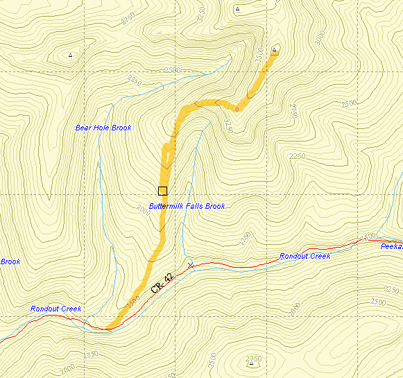
Turn onto Route 52A near the TriValley School. Stay on the road until the hamlet of Sundown where
the road turns left. Bear to the right on Peekamoose Rd. and continue on the road until parking areas
begin to show up on the left. The parking area most use to climb the mountain is the sixth marked spot
and indicates the beginning of the Peekamoose-Table trail. Park here and start up the blue-blazed
trail. After 2.3 miles you reach Reconnoiter Rock which has a nice view. Climb for about .75 miles
and there is a rock ledge with opens views to the south. The summit of Peekamoose Mountain (3843 ft.)
is .85 miles further. The Trail continues on to the Denning trail head but your car is back on the Peekamoose Rd. Turn around and retrace your route to the car.
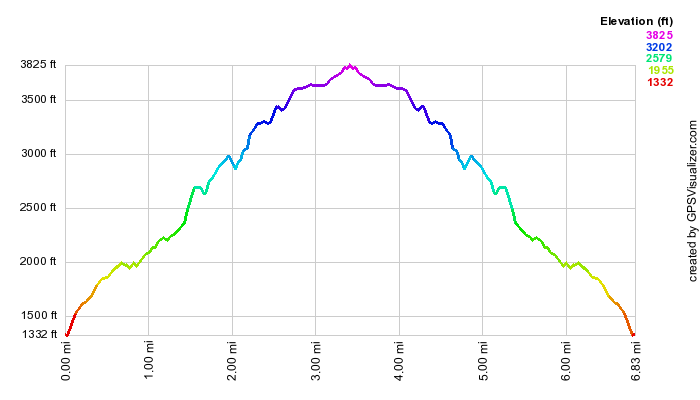
(The image is the vertical profile for the hike.)
Peekamoose Road from Peekamoose to Long Path Turn
| Quick Look - Peekamoose Road | |||
|---|---|---|---|
| Difficulty | Round trip | Total climb | Internet Maps |
| 1.0 mi. | 159 ft. | AllTrails | |
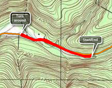
This hike connects the hike over Table and Peekamoose Mountains with the next section of the Long Path with a short walk along Peekamoose Road. This short walk could be included as part of a longer hike on either section.
Turn onto Route 52A near the TriValley School. Stay on the road until the hamlet of Sundown where the road turns left. Bear to the left on Peekamoose Rd. and continue on the road until parking areas begin to show up on the left. The parking area most use to climb the Peekamoose is the sixth marked spot and indicates the beginning of the Peekamoose-Table trail. Park here and walk on the road following the aqua blazes of Long Path. In .5 miles there will be a small parking area on the right and the Long Path will turn left near a very large boulder. The Long Path continues over Bangle hill to Vernooy Kill Falls and Cherrytown Road. Turn around and walk back to the car.
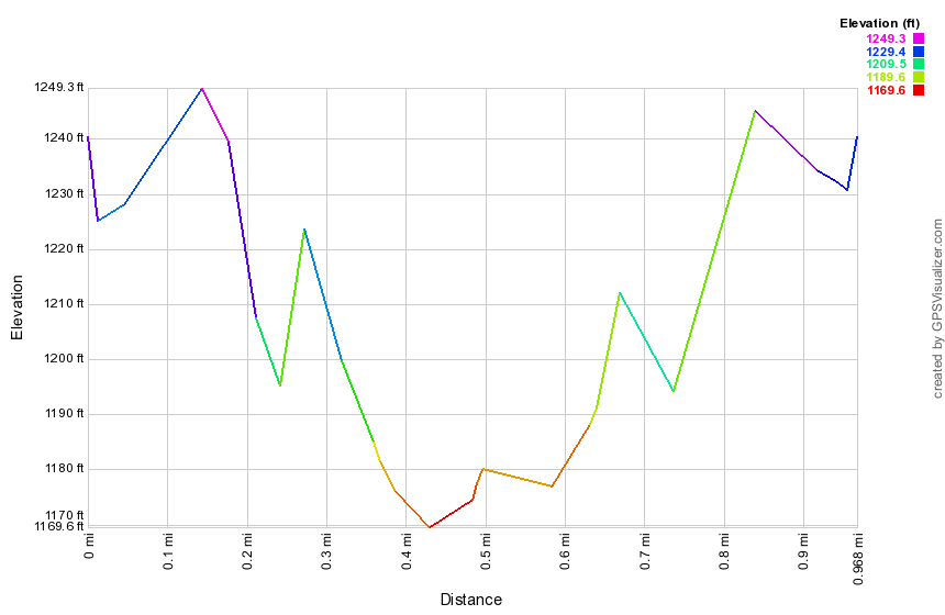
(The image above is the vertical profile for the hike.)
Vernooy Kill Falls: From Peekamoose
| Quick Look | |||
|---|---|---|---|
| Difficulty | Round trip | Total climb | Internet Maps |
| 9.5 mi | 1695 ft | AllTrails | |
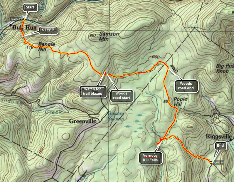 Turn onto Route 52A near the TriValley School. Stay on the road until the hamlet of Sundown where the road turns left. Bear to the left on Peekamoose Rd. and continue on the road until parking areas begin to show up on the left. Watch for a brown and yellow sign on the right for the Long Path toward Cherrytown Road. There is a small parking area opposite the start of this trail. The next parking area on the left is the Upper Peekamoose Parking Area and is much larger. Of course, you may also reach this area by turning onto Peekamoose Road off Route 28A, the road that runs along the south side of the Ashokan Reservoir. Once you are on the trail there is a climb of over 1100 feet in the first mile to the top of Bangle Hill. As you walk up the trail look over your left shoulder for a view of Peekamoose Mountain. There is a small set of ledges near the top of Bangle hill but they are VERY small. From the top of Bangle Hill the trail turns east and descends for some distance until ascending to the highest point just south of Samson Mountain after about 2.4 miles. Turning north hear there is a short, about .6 mile, bushwhack to the top of Samson Mountain. The trail continues to descend and opens up to a wide woods road. At mile 3.2 the trail turns heard to the right off the road. If you continue ahead on the woods road, there is a small stone shed and evidence of other foundations and stone walls.
The trail continues to descends through spruce and hardwood groves until it meets Spencer Road at 3.5 miles. Turn left on the road and walk about 1.3 miles east and northeast until mile 4.8. The trail markers are few and far between but do NOT worry about missing the turn to the right back into the woods and off the road. The trail is well marked but the walk along the road seems long. The trail turns almost due south and descends some until a slight climb to the top of Popel Hill at mile 6.0. Watch for a "witness sign" to your right and a USGS marker apparently in the middle of nowhere. From here the trail turns a little to the southeast before continue south to the falls at mile 7.2. The falls are more of a set of rapids and cataracts than one continuous drop of water. Walk upstream on either side to take in all the beauty of the various "steps" to the falls. There is no formal trail but you will have no trouble finding your way. Near the bridge are the ruins of a mill built by the Vernooy family that first owned the land. Standing on the rocks in the middle of the stream offers a great view of the bridge and many of the different steps to the falls. It also offers a good opportunity to fall in so be careful. After exploring the area of the falls, get back on the trail. You may now hike the 7 miles back to your car or hike out to Cherrytown Road where you had the foresight to park another car for the shuttle. From the falls the trail heads east and then southeast but always descends until you reach the parking area at about mile 9.0.
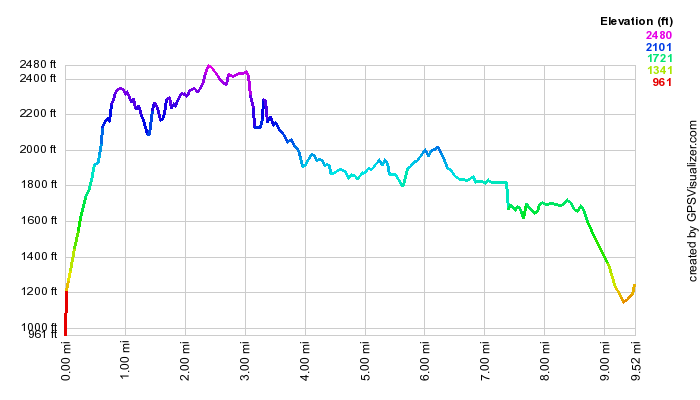 (The image at the left shows the profile of the hike. Remember that all vertical profiles are
relative!)
(The image at the left shows the profile of the hike. Remember that all vertical profiles are
relative!)
Riggsville to Cherrytown Road
| Quick Look | |||
|---|---|---|---|
| Difficulty | Round trip | Total climb | Internet Maps |
| 6.0 mi | 1695 ft | AllTrails | |
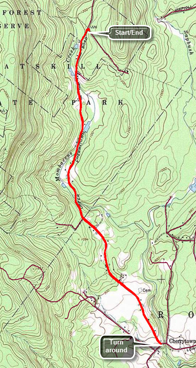 Turn north on Samsonville Road off Route 209 just east of Kerhonksen. Drive 1.25 miles and then turn left on Cherrytown Road. Continue on Cherrytown Road for 3.5 miles to the intersection with Upper Cherrytown Road. Bear left here and follow Upper Cherrytown Road for 3 miles where there is a parking area on the right side of the road. Leave the parking area and turn left. Walk 3 miles south on the road to the intersection of Upper Cherrytown Rd and Cherrytwon Rd. The walk in slightly downhill and you will lose about 500 feet along the way. At the intersection turn around and walk the 3 miles back uphill to the car.
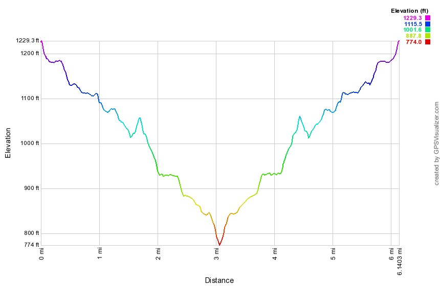
(The image shows the profile of the hike. Remember that all vertical profiles are relative!)
Lundy Quarry to Upper Cherrytown Road
| Quick Look | |||
|---|---|---|---|
| Difficulty | Round trip | Total climb | Internet Maps |
| 12.0 mi | 1230 ft | AllTrails | |
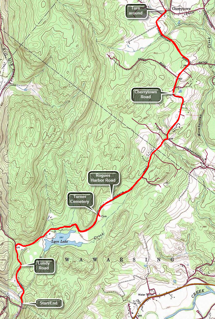 Turn north on Lundy Road off Route 209 just northeast of the Wawarsing Post Office. Continue on Lundy Road for about 1.4 miles to the quarry and park on the right side of the road.Walk north on Lundy Road which is a mixture of dirt and gravel. It winds through some nice evergreen forests for about .8 miles to the intersection with Rogues Harbor Road. The area feels remote and the walk is slightly uphill gaining about 230 feet. Turn right on Rogues Harbor Road which heads ENE. Within .3 miles, a high wooden fence appears on the right which blocks the view of Lyon Lake. This is a rather upscale and private club or community. The fence extends for more than .5 miles or the entire length of the lake. After this the trail seems flat but does roll some. There is a slight climb to the intersection with Woodland Ridge Road. Along the way at 2.3 miles there is a sign that reads "Turner Cemetery" and points south into the woods along a faint path. The road surface changes to pavement as you descend to Cherrytown Road at 3.7 miles. Turn left on paved Cherrytown Road and immediately start uphill although the ascent is not steep. From the turn onto Cherrytown Road you will gain another 200 feet to the intersection with Mount Laurel Road where the road levels. From Mount Laurel Road it is another 1.2 miles to the intersection with Upper Cherrytown Road. Along the way there are many small farms many with horses and other farm animals. At the intersection turn left on Upper Cherrytown Road and walk a short distance before turning around and starting the hike back. The remaining portion of this section is only 3 miles for a round trip of 6 miles.
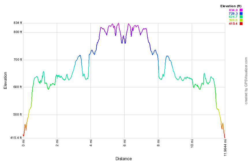
(The image shows the profile of the hike. Remember that all vertical profiles are relative!)
Berme Road to Lundy Quarry
| Quick Look | |||
|---|---|---|---|
| Difficulty | Round trip | Total climb | Internet Maps |
| 5.8 mi | 445 ft | AllTrails | |
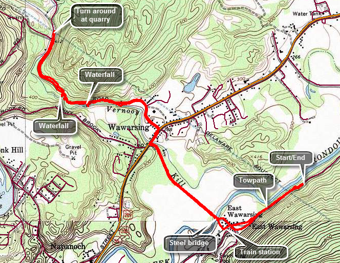 Take Route 52 through Ellenville heading east over the mountain. Just before the road began its trip up the mountain, turn left on Berme Road and drive about 4 miles to where the Long Path crosses the road. There is room for one or two cars to park on the side of the road. Cross Berme Road and walk down the bank until you spot a Long Path marker on the old D and H Canal towpath below. Follow the towpath as it parallels Berme Road. The trail is often filled with garbage and walking on the road may be preferable! At about .5 miles the towpath turns into Towpath Road which crosses Port Ben Road. Towpath Road leads back to Port Ben Road and crosses Rondout Creek on a very old metal bridge. Port Ben Road stretches out ahead passing between two fields. Walk for .7 miles on Port Ben Road to the point were it ends on Route 209. Route 209 is a busy road but it had a sidewalk on the near side so turn right and walk a short distance to Lundy Road. Turn left and head generally northwest as Lundy Road begins a very gentle ascent following the Vernooy Kill. You can hear and see various rapids on the creek. Lundy Road very quickly turns to a gravel surface but there is almost no traffic. At 2.1 miles there is an interesting waterfall caused by what looks like an old dam across the stream. At 2.4 miles into the hike there is another small waterfall. The road continues to gain some elevation and at 2.8 miles pass Cutler Road on the left. The long range plans for the Long Path include taking the trail off Lundy Road at this point and continuing along the Vernooy Kill to the falls. In a few hundred feet the quarry will be on the right side of the road at 2.9 miles. Return the way you came.
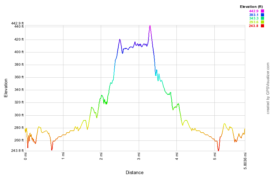 (The image at the left shows the profile of the hike. Remember that all vertical profiles are relative!)
Berme Road to Berrypickers Path
| Quick Look | |||
|---|---|---|---|
| Difficulty | Round trip | Total climb | Internet Maps |
| 5.8 mi | 445 ft | AllTrails | |
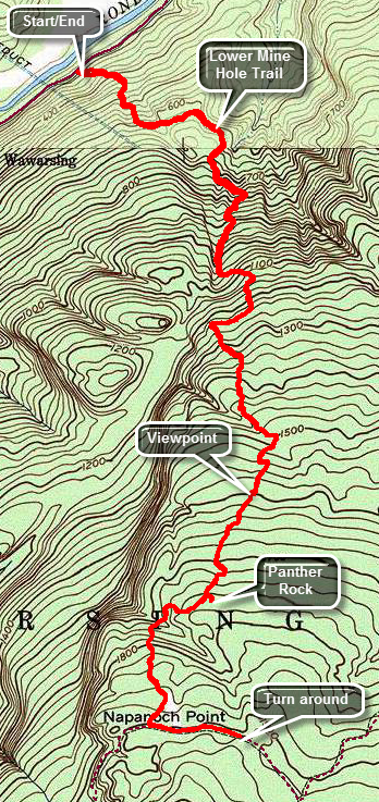 Take Route 52 through Ellenville heading east over the mountain. Just before the road began its trip up the mountain, turn left on Berme Road and drive about 4 miles to where the Long Path crosses the road. There is room for one or two cars to park on the side of the road. Follow the aqua blazes through hardwood forests consisting mostly of oak trees. The trail is pretty easy to follow as it uses woods roads and is pretty well marked. At .7 miles turn left on another woods road which is also marked as the Lower Mine Hole Trail coming up from Foordmore Road. The trail is rocky and layers of oak leaves can make it slippery underfoot. The trail heads south and continues climbing toward the ridge. At about 1.4 miles the trail turns west to avoid some ledges and then turns south again. At an elevation of about 1230 feet the typical Sam's Point and Shawangunk vegetation appears. There are now open rock faces with scrub pine and the transition is sudden and stunning. Keep looking back over your shoulder as viewpoints begin to appear. From some lookouts you can see the valley below and the mountains of the Catskills beyond to the north. Keep an eye out for the side trail on the right to Jacob's Ladder which you may want to visit. Also watch for a path on the left to Panther Rock which is a great lookout. The trail is marked with a sign saying "Panther Rock" and is blazed in white. It is only a few hundred feet out to Panther Rock but it is certainly worth the trip. Climb up to the top of Panther Rock and find views similar to other viewpoints but unobstructed and more expansive. Continue heading southwest and climbing. Just after Panther Rock descend a little and cross a stream before climbing again. At 3.4 miles you will hit the Smiley Carriageway. Turn left and walk to the beginning of the Berrypickers Trail which is only about a quarter mile away. Once you are at the beginning of the Berrypickers Path, head back down along the same path you used on the way up.
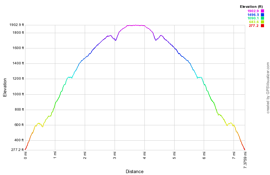
(The image shows the profile of the hike. Remember that all vertical profiles are relative!)
Sam's Point: Napanoch Point and Berrypicker's Trail
| Quick Look | |||
|---|---|---|---|
| Difficulty | Round trip | Total climb | Internet Maps |
| 10.9 mi. | 1137 ft. | AllTrails | |
 The hiking trails throughout the Sam's Point Preserve vary from open carriageway to narrow "maintained"
trails through the brush, over the bogs and around many interesting rock formations. There are
several different variations in length from the trail through the Ice Caves and to Sam's Point which
is about 4 miles to the 10.5 mile complete loop. The ecology is a pine barrens with some hardwood
sections and many boggy areas. Verkeerder Kill falls is well worth the visit as are the Ice Caves.
These "caves" are actually tectonic caves formed when part of the mountain pulled away forming
deep crevices in the rock.
The hiking trails throughout the Sam's Point Preserve vary from open carriageway to narrow "maintained"
trails through the brush, over the bogs and around many interesting rock formations. There are
several different variations in length from the trail through the Ice Caves and to Sam's Point which
is about 4 miles to the 10.5 mile complete loop. The ecology is a pine barrens with some hardwood
sections and many boggy areas. Verkeerder Kill falls is well worth the visit as are the Ice Caves.
These "caves" are actually tectonic caves formed when part of the mountain pulled away forming
deep crevices in the rock.
Park in the lot at the Visitor's Center at Sam's Point. Be sure you pay the parking fee or buy a pass that is good for a year. As you walk toward the trails, you may bear to the left or right. Bear to the left and begin to hike up the loop road on a gentle grade. Watch on your left for some of the shacks used by blueberry pickers in years gone by. These shacks are all but gone but hark back to an era when berry picking was a commercial venture. At about .3 miles the South Gully Trail branches left off the loop road. This trail leads down to Route 52 and is a hike all by itself. There are several waterfalls and cascades along the trail as it parallels a stream. Continue to walk along the loop road. At about 1.0 mile there will be a short side trail that goes to the shore of Lake Maratanza. Depending on the level of the lake, this may or may not prove interesting. At this point you will start to see TV and other communications towers on your left. The High Point Carriageway bears to the left off the loop road at 1.2 miles. At about 1.5 miles a trail to the left leads to Indian Rock. Although this glacial erratic is interesting and has a nice view, save it for another, shorter hike. Continue north on the carriageway to 2.75 miles where there is a junction with the High Point Trail and the Smiley Carriageway. Continue straight ahead on the carriageway but be aware that it is not well-marked in places and can have some very wet spots along the way, The path descends to about 3.85 miles where it begins to rise some. At 4.15 miles informal pathways lead off to the left to Napanoch Point. Turn left here for a short bushwhack out to this viewpoint. You may also find some areas where there have been campfires. Return to the main path and at 4.4 miles another path heads left or north toward Jacob's Ladder. You may turn here and walk about .4 miles since there are some views on this descent. Turn around and walk back to the main carriageway and turn left. At 5.6 miles the Berrypicker's Path branches off to the right. Make the turn and be prepared for a 1.8 mile uphill walk across open rock and through scrub pines. Along the way hikers have created cairns and other designs with stones. At the end of this trail you will be in the area where there was once a fire tower. Before descending back to the High Point Carriageway, follow the High Point Trail .3 miles to High Point. A USGS marker is embedded here in the stone. Retrace your path and descend to the High Point Carriageway and turn left to start back to the Visitors Center. At 9.3 miles the spur trail to Indian Rock will be on your right. When you reach the Loop Road at 9.7 miles turn right. The communications towers will be on your right. At 10.6 miles you will pass by the South Gully Trail and the berrypicker's shacks. From here it is a short walk to your car.
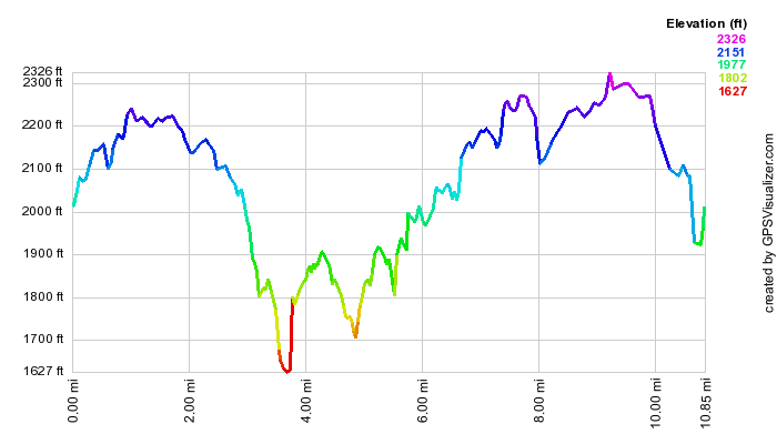 (The image shows the profile of the hike. Remember that all vertical profiles are relative!)
Sam's Point: Main Loop
| Quick Look | |||
|---|---|---|---|
| Difficulty | Round trip | Total climb | Internet Maps |
| 8.8 mi. | 1220 ft. | AllTrails | |
 The hiking trails throughout the Sam's Point Preserve vary from open carriageway to narrow "maintained"
trails through the brush, over the bogs and around many interesting rock formations. There are
several different variations in length from the trail through the Ice Caves and to Sam's Point which
is about 4 miles to the 10.5 mile complete loop. The ecology is a pine barrens with some hardwood
sections and many boggy areas. Verkeerder Kill falls is well worth the visit as are the Ice Caves.
These "caves" are actually tectonic caves formed when part of the mountain pulled away forming
deep crevices in the rock.
The hiking trails throughout the Sam's Point Preserve vary from open carriageway to narrow "maintained"
trails through the brush, over the bogs and around many interesting rock formations. There are
several different variations in length from the trail through the Ice Caves and to Sam's Point which
is about 4 miles to the 10.5 mile complete loop. The ecology is a pine barrens with some hardwood
sections and many boggy areas. Verkeerder Kill falls is well worth the visit as are the Ice Caves.
These "caves" are actually tectonic caves formed when part of the mountain pulled away forming
deep crevices in the rock.
Park in the lot at the Visitor's Center at Sam's Point. Be sure you pay the parking fee or buy a pass that is good for a year. As you walk toward the trails, you may bear to the left or right. Bear to the right on the Loop Road toward Sam's Point. This hike leaves out many of the "attractions" in favor of a slightly shorter(?) hike. As you ascend the road there will be good views from open rocks ledges on the right. Pass by the side path to Sam's Point and continue on to the road. Turn right on the road that goes down to the ice caves. Turn then a left onto the Verkeerder Kill Falls Trail which has the aqua blazes of the Long Path. This trail has some beautiful views out over the flat valley on your right. Straight ahead on the trail you will see the cliffs of Castle Point and Hamilton Point at Minnewaska State Park and the blue waters of Lake Awosting. The trail drops 500 feet in about 1.75 miles to the lowest point on the hike at Verkeerder Kill Falls at 2.9 miles into the hike. There are lookouts on both sides of the falls. The falls are more interesting when there has been some rainfall but this makes crossing the stream above the falls more dangerous! After observing the falls from the far side, continue on the trail as it rises to a trail junction over the next .3 miles. Bear left on the red High Point Trail. For the next 2 miles this trail follows the edge of the escarpment on its way to High Point. The trail has some fantastic views over the valley and you can always take a look back at where you have been and ahead to where you are going. As the trail approaches High Point it passes through some brush. The trail here may be wet depending on the recent rainfall and the brush may be thick. The red blazes are painted on the rocks and may be hard to see. At about 5.4 miles, you will climb a steep spot and be on High Point which is marked by a USGS benchmark. Continue on the trail for another .3 miles to an area where there was once a fire observation tower. You can still see the iron moorings of the tower embedded in the rock. Walk down the trail to where it ends on the High Point Carriageway. Turn left to start back to the Visitors Center. The carriageway gains some elevation until and 7.25 miles the spur trail to Indian Rock appears on the right. Continue on the carriageway to the Loop Road at 7.6 miles. Turn right on the road in the area where there are several communications towers. The road now continuously descends over the next 1.2 miles until you are back in the parking lot. Along the way you may see what remains of the sheds used by blueberry pickers back in the day when that was a commercial enterprise. At 8.5 miles the South Gully Trail will be on the right. This trail is a nice hike on its own and is part of the Long Path. When the South Gully Trail gets to Route 52, It connects to the Shawangunk Ridge Trail.
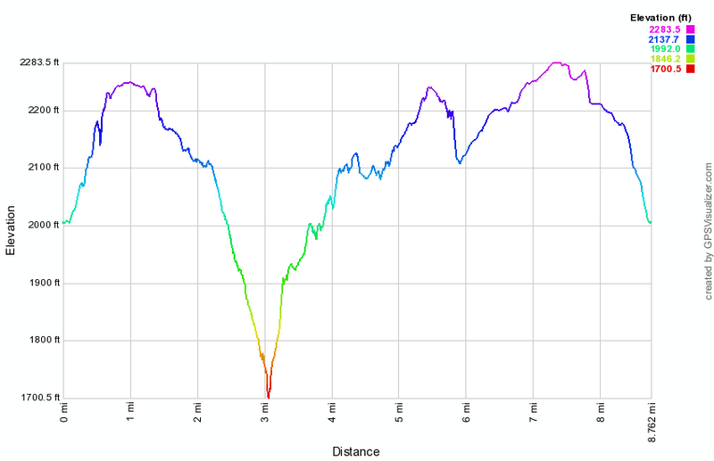 (The image at the left shows the profile of the hike. Remember that all vertical profiles are relative!)
Sam's Point: South Gully Trail Only
| Quick Look | |||
|---|---|---|---|
| Difficulty | Round trip | Total climb | Internet Maps |
| 6.1 mi. | 2143 ft. | AllTrails | |

Take New York State Route 52 east from Ellenville. The road will begin to climb the Shawangunk Ridge as soon as you leave town. The road winds up along the ridge and there are several pulloffs on the way up. On a clear day park at one of these areas and enjoy the view of the valley and the Catskills beyond. Just as the road leaves town look on the left as you pass over a bridge. There is a beautiful waterfall with small rapids below it. About 1.1 miles from this waterfall Route 52 will cross South Gully on a bridge. At the end of the bridge is a wide shoulder on the left side of the road. Turn around and park on the wide shoulder by the guardrail. This is where the trail begins. The first part of the trail drops a little from the road to the stream that forms South Gully. At the bottom of the descent, you may walk over to the stream and take some pictures before getting back on the trail. There are MANY small waterfalls and rapids along the stream! In some places the trail almost disappears and you must sidehill. Slippery leaves and pine needles makes this section of trail interesting. You may want to walk down to the stream at several points along the way to take pictures of some of the small waterfalls and rapids. At about 2.1 miles you will come to South Gully Road. Walk out to the road and turn left. Walk across the road and downhill for a short distance before picking up the trail on the other side.
From South Gully Road the trail becomes a little steeper before leveling off near the top of the plateau. Over the first 2 miles you will gain just over 300 feet. In the next mile to the junction with the loop road, the gain is almost 700 feet. At around 3 miles you will reach the Loop Road at Sam's Point. Turn around and retrace your route back to the car at 9.2 miles.
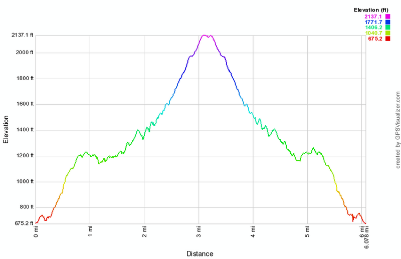
(The image at the left shows the profile of the hike. Remember that all vertical profiles are relative!)
Shawangunk Ridge Trail: South Gully to Shawangunk SF
| Quick Look | |||
|---|---|---|---|
| Difficulty | Round trip | Total climb | Internet Maps |
| 6.9 mi. | 1594 ft. | AllTrails | |
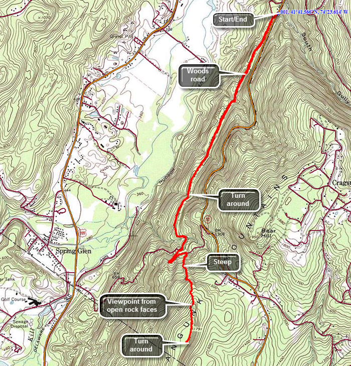 The Shawangunk Ridge Trail runs from High Point State Park in New Jersey to the Mohonk Preserve. The hike may be broken into sections. This section is an out and back hike from the South Gully Trail on Route 52 outside of Ellenville near the Sam's Point Preserve to the top of the first ridge.
Take Route 52 out of Ellenville and drive up the mountain heading toward Pine Bush. Pull over just after the South Gully bridge. Turn around and park on the wide shoulder near the trailhead. Cross the road to pick up the Long Path and SRT heading south. The trail descends from the road and the trail markings immediately disappear at a T! Turn left on what is marked on the maps as Old Route 52 and find the aqua blazes of the Long Path which seem to alternate with the dark blue blazes of the SRT. The road is wide and grassy at this point and is mostly uphill. Continue on the road which became MUCH rockier in places and continues to head uphill on a very slight grade. You will cross several small streams heading generally southwest. At 2.4 miles the trail suddenly turns 180 degrees and heads northeast to avoid descending into a deep ravine. At 2.6 miles you will reach a trail junction with the yellow connector trail which continues straight ahead to a parking area on Route 52. Turn right to stay on the Long Path and SRT. The trail immediately begins to climb up a ridge and is at times steep. There are open rock faces to climb over and some can be a little slippery from the accumulation of pine needles. Within a short distance there is an open rock face with some nice views to the west and north. The ascent continues for another .6 miles and gains 675 feet with an average grade of right around 20% but with some areas nearly 30%. You can turn around when you like but it is worth it to continue to the highest point on the ridge. In two or three more spots there are open views from rock faces. The trail begins to level off at 3.25 miles and can be quite overgrown by laurel and scrub oak. Walked a little farther to 3.5 miles and then turned around to head back
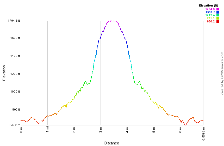
(The image shows the profile of the hike. Remember that all vertical profiles are relative!)
Shawangunk Ridge Trail: Wurtsboro to Ellenville
| Quick Look | |||
|---|---|---|---|
| Difficulty | Round trip | Total climb | Internet Maps |
| 8.6 mi. | 2730 ft. | AllTrails | |
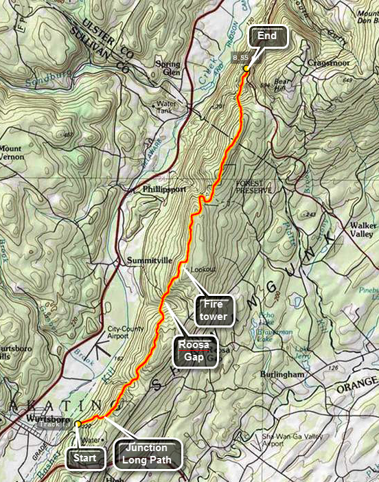 The Shawangunk Ridge Trail runs from High Point State Park in New Jersey to Sam's Point Preserve, The hike may be broken into sections. This section is a through hike from Wurtsboro north to Route 52 outside of Ellenville near the Sam's Point Preserve.
Park a car in the pull off 1.7 miles south of South Gully on Route 52 heading out of Ellenville. Drive to the VFW in Wurtsboro on VFW Road off Sullivan Avenue. You may use back roads to get to Wurtsboro or drive there on Route 209. The trail starts with a nice "warm up" of 600 feet of elevation gain over the first .95 miles. From here there are views of the Basha Kill to the southwest and the Catskills to the north. The Wurtsboro Airport and the massive Kohl's Distribution Center dominate the valley below. Immediately after the climb the trail descends into the next gap on the ridge. The descent is a little steep in places losing 400 feet in .45 miles. There is a small stream at the bottom just before the next climb. Over the next.9 miles the trail rises 470 feet but the reward are the views from the ridge. The views of the Catskills and the ridge across from the Shawangunk Ridge dominate the views. From this ridge you begin a steep descent to the lowest point on the route except for the very beginning. The trail drops 600 feet in the next .85 miles to Roosa Gap. There is another small stream here surrounded by ferns in season. Watch for the flowers from tulip trees in the spring and summer. The next section of the trail is a .7 mile climb that gains 725 feet. After this, the trail continues to rise but does so very gently for the next .8 miles. In the first part you will cross Roosa Gap Road. As you climb the ridge you can look back at the ridge you just left. At 5.15 miles the trail descends again and then begins to climb. The climb is gentle at first but then steepens some. This climb lasts 1.8 miles and rises to 780 feet, the highest point on this section of the trail. This part of the trail skirts the edge of the ridge before crossing over to the highest point. Along the way some interesting rock formations present themselves. One rock tower stands away from the edge of the cliff and is very interesting.
From the highest point the trail drops VERY steeply, losing 700 feet of elevation in about .5 miles. The trail makes its way down to the woods road that is the Old Route 52. The Long Path heads north from here as the road turns left. Pick up the yellow trail that leads UP to Route 52 where your car is parked. This trail is less than 1 mile long and passes over a small stream with a waterfall. From that point there is a short but steep ascent to the main road. As you turn left on Route 52 to get back to the parking area, watch for hang gliders plying the air currents above the area. Also take advantage of the beautiful views from the parking areas along the road. Don't forget to go get your other car in Wurtsboro!
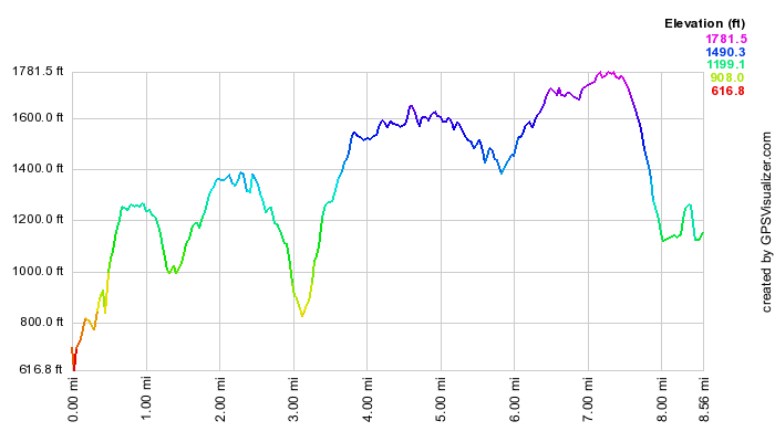 (The image at the left shows the profile of the hike. Remember that all vertical profiles are relative!)
Shawangunk Ridge Trail: Haven Road to Wurtsboro VFW
| Quick Look | |||
|---|---|---|---|
| Difficulty | Round trip | Total climb | Internet Maps |
| 9.1 mi. | 400 ft. | AllTrails | |
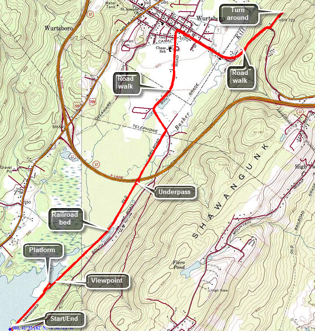 Take the Quickway (Route 17/I86) to the exit for Route 209 in Wurtsboro and head south toward Port Jervis. After about 2 miles turn left on Haven Road. Follow the road as it crosses over the Basha Kill. At the first intersection turn left and park in the large lot. Head northeast on the old railroad bed which makes up a good part of the SRT in this area. There are no blazes for either the SRT or Long Path but the route is clear as it simply follows the railbed. Within a short distance there is a nice viewpoint over the Basha Kill to the ridges beyond. You may encounter a few wet areas on the trail and some mud. There were also several places where old wooden bridges were cross the water. These bridges are slowly deteriorating and the whole atmosphere is one of neglect. At 1.8 miles there is an underpass beneath the highway allows hikers and wildlife to pass under the highway without a problem! At 2.3 miles the trail ends and the road walk begins. Turn left on South Road which eventually turns into Pennsylvania Avenue. It is rather pleasant walking on the flat and level road. As you near town, you will come across the D and H Canal Linear Park. A sign explains that Wurtsboro was named after Maurice Wurts who was the president and founder of the D and H Canal. There is also a stone snubbing post that was used to control the coal barges. When you arrive at Sullivan Avenue, the main street of Wurtsboro, turn right and head southeast, crossing the old railroad bed again at 3.8 miles. To this point the hike has been nearly flat gaining only 100 feet. This changes as you leave the Village of Wurtsboro and head up the hill to VFW Road. In truth the "climb" is only about 200 feet in .7 miles making an average grade of only 6%. Make the left turn onto VFW Road and hike a short distance to the post. The tail enters the woods from the parking area just beyond the post. The return trip is simply a reverse of the route from the way out since no viable loop options exist.
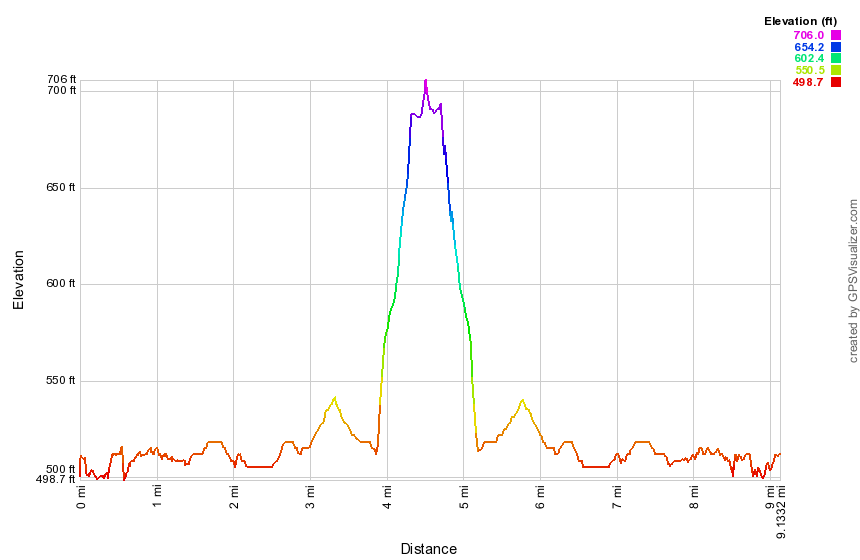
(The image above shows the profile of the hike. Remember that all vertical profiles are relative!)
Shawangunk Ridge Trail: Basha Kill Southern Loop
| Quick Look | |||
|---|---|---|---|
| Difficulty | Round trip | Total climb | Internet Maps |
| 10.4 mi. | 520 ft. | AllTrails | |
 The Basha Kill is a 2400 acre wetland and wildlife preserve in the southern part of Sullivan County. Among other things it is home to at least 50 species of birds and especially bald eagles. The remains of the Port Jervis to Kingston branch of the O&W forms a rail trail on the southeastern shore. On the northwestern shore is the D&H Canal and the towpath. The two can be combined for a loop using Haven Road to cross the marsh on the northern end and Otisville Road to swing around the southern end.
Take Route 17/I 86 to exit 113 and head south on Route 209. After about 1.7 miles Haven Road appears on the left. Turn left here and drive to the parking area on the left to park. Start your hike by walking east on Haven Road through the marsh toward the rail trail on the eastern shore. Turned left or north on the rail trail. The trail here is relatively firm even when it has been raining. After about a mile watch for a trail to an observation tower and turn left on this unmarked trail. Within .1 miles you will be at the tower which is more of an observation platform. There are nice views over the marsh to the north and west. At Haven Road cross to the other side and to follow the rail trail south. The trail can be VERY wet in places especially after it rains so you may have to cross from one side to the other or use the banks to make it through this area. The banks are covered in barberry and some other thorny brush so making progress can be slow and painful. The rail trail dries out after this but still may have a few muddy spots along the way. There are views of the marsh all along the way. The trail is extremely straight which is not surprising given that it is the old railroad bed. At 3.7 miles there is one of the larger parking areas just off South Road and near the Basha Kill Winery. The water is more open in this area and people like to canoe or kayak from here. When you leave the parking area, continue on the trail which is often wet and muddy. In about .4 miles the Long Path markings appear to head to the right off the rail trail but this may be a dead end. Continue to head south on the rail trail and watch for a sign that says "Long Path". At about 4.3 miles the trail again may became wet and muddy. Turn left off the trail and walk out to the road. AVOID private property postings as there are a few in the area. Once on the road, continue south and at 4.5 miles the road will cross a small stream. Look to the left and see a beautiful waterfall. The posting in the area is unclear so read carefully before proceeding! Walk to the base of the falls and get a view of the water flowing down over a wall of rock. Walk back out to the road to continue. Walking on the road goes quickly and in about another mile at 5.5 miles into the hike there is a small parking area on the right with an observation deck. The deck gives a nice view of a stream flowing out of the Basha Kill. Turn right out of the parking area and walk to the intersection. Turn right on Otisville Road which runs out to Route 209. The D&H Canal towpath should intersect the road just before Route 209. If you cannot find the towpath, walk out to Route 209 and turn right on the road. Walk .2 miles on the road, to a sign for the Basha Kill and turn right down this dirt road. As you approached a flat area a path turns left across a field and into the trees. As you enter the trees and walk up a small incline turn right. This is the towpath. The canal and the towpath have an interesting history and I am sorry to say I don't know enough about it. The canal ran to the left or west of the towpath and in many places the canal is still very obvious. There are still stone walls on either side of the canal and even the trees that now grow in it cannot hide it. Head north and then east to get around a hill before heading north for most of the rest of the trip. The canal is now dry in most places but in some areas there is water which hints at the original purpose. In a few places you will see bridges of rock built across the canal. After the canal was no longer in use, these bridges were built across it to reach the towpath and the Basha Kill. At 7.5 miles a dirt road runs down to the Stonefield parking area and this continuous for about .35 miles. Continue on the towpath when the road turns into a parking area and at 8.25 miles there will be a bridge that was built over the original canal. The span of the bridge no longer exists but the stonework that made up the abutments is still there. Also present are the stone walls that lined the lane that leads up to the bridge. A little further on the trail crosses a chasm on a wood bridge. Just to the left is another stone bridge that crossed the canal. At 10.1 miles there is a gate which leads out onto Towpath Road. This short road soon intersects Haven Road. Turn right and walk .3 miles back to the car.
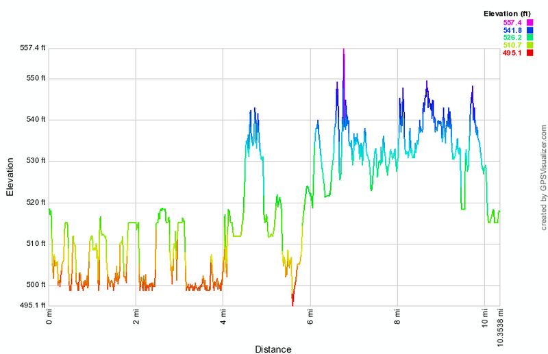 (The image at the left shows the profile of the hike. Remember that all vertical profiles are relative!)
Shawangunk Ridge Trail: Basha Kill to Guymard Turnpike
| Quick Look | |||
|---|---|---|---|
| Difficulty | Round trip | Total climb | Internet Maps |
| 12.0 mi. | 1376 ft. | AllTrails | |
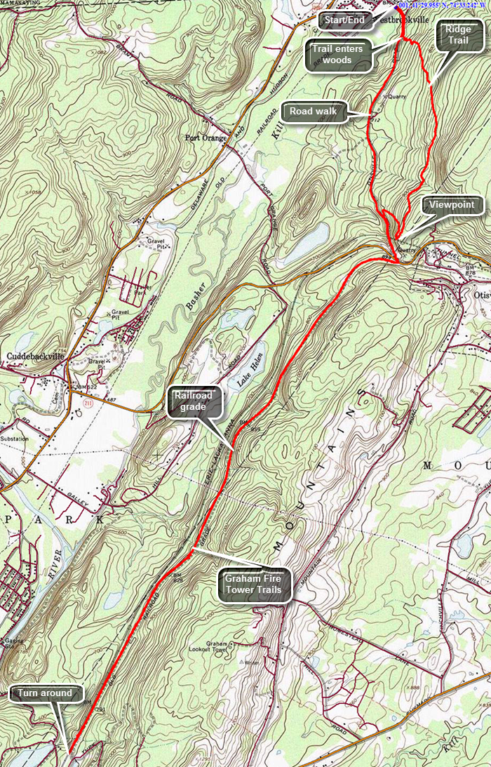 Take the Quickway (Route 17/I86) to the exit for Route 209 in Wurtsboro and head south toward Port Jervis. After about 6 miles and turn left on Route 61 toward Otisville. Just before the bridge over the Basha Kill park in a small lot on the right side of the road. Start your hike by heading southeast on Route 61 and crossing over the bridge across the Basha Kill. The Long Path and Shawangunk Ridge Trails are co-aligned here and you should pick them up at the corner of Indian Orchard Road. Follow the markings southeast on Route 61 for about .25 miles to the point where the trail enters the forest on the left side of the road. The bank is very steep and the trail goes through several switchbacks as it climbs toward the top of the ridge. Over the next .75 miles you will gain over 400 feet. The trail may be lightly used and the markers can be hard to spot so pay careful attention as you hike! The trail meanders back and forth and at about 1.75 miles you will hit the highest point at 1035 feet. The trail never actually hits the highest point on the ridge which seems to be about 1200 feet. As you walk along the ridge, there are no opportunities for views and not much of any interest. Around 1 mile the trail turns onto a wide and well-maintained woods road but this only lasts until about 1.25 miles when the trail turns into the woods. At 1.8 miles start a slight descent and find that the trail seems to split with the marked trail going to the right. Go to the left to find a nice viewpoint over the valley below. Go back to the main trail and begin a descent to the road. In .2 miles you will drop a little over 200 feet and at the end you will be at Route 61. There are NO MARKERS here to indicate which way to turn! Turn left and walk up the hill to the junction with Route 211. There is a parking area at the intersection with some blazes. Cross the road diagonally to the left and pick up the trail which follows the old railroad bed for the rest of hike out. The railroad bed runs southwest and parallel to the existing Conrail tracks. It is very level and very straight for most of its length. The surface varies from hard-packed cinders to areas that have angular stones which makes walking more difficult. There are a few areas where water has accumulated but these are easily avoided. Sometimes it runs under the cover of trees but in other places it is completely open. Shortly after the beginning of the railroad bed a huge powerline comes in from the west and then follows the course of the railroad bed for some distance. At one point the two part for a short distance but then join again. At about 4.4 miles the powerline joins another and leaves the railroad bed. About half a mile beyond this point or 4.9 miles into the hike watch for the trail markers for the trails to the Graham Fire Tower on the left. Both the white Tower Trail and the red Ravine Trail originate in the same place but take different approaches to the top. At about 4.9 miles there is an open area on the left side of the trail and you will see two trees with markers. One tree has three red markers for the beginning of the Tower Trail and the other has three white markers for the beginning of the Ravine Trail. You now have a choice to make. You may turn around here and return to your car. You may hike to the fire tower and then return to your car. You can continue to hike on the main trail to Guymard before you turn around. Hiking to Guymard adds another 1.7 miles to your trip and there isn't much to see. It may help you complete a section of the Long Path and the Shawangunk Ridge Trail. On your return trip you may want to use Route 61 to get back to the car to avoid the hike up and over the ridge again. The hike is, of course, a road hike but it is all downhill, the shoulders are wide and it is only 1.7 miles.
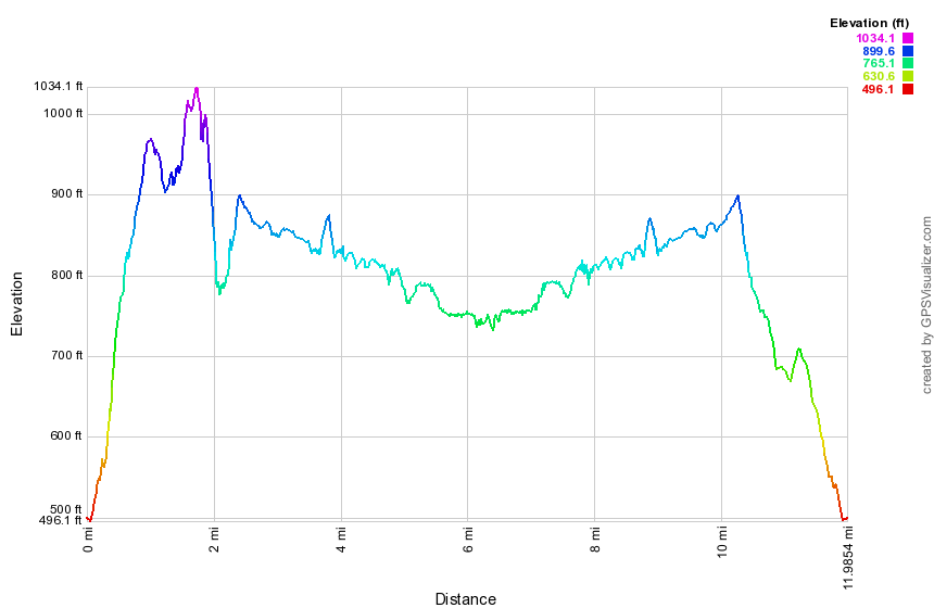
(The image above shows the profile of the hike. Remember that all vertical profiles are relative!)
Shawangunk Ridge Trail: Graham Fire Tower
| Quick Look | |||
|---|---|---|---|
| Difficulty | Round trip | Total climb | Internet Maps |
| 5.3 mi. | 800 ft. | AllTrails | |
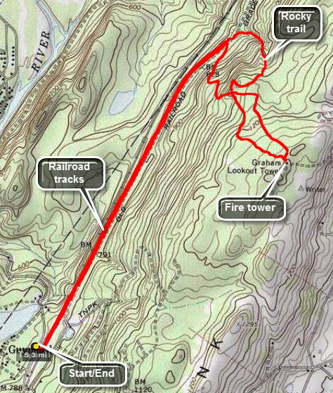 Drive to the hamlet of Godeffroy on Route 209 about 5.5 miles north of Port Jervis. Watch for the Guymard Turnpike on the east side of the road. Turn onto the turnpike and drive about .7 miles to a T. Turn right to follow the turnpike as it ascends and passes by one end of Guymard Lake. In about .2 miles park on the side of the road. The train tracks are active so look and listen before crossing to the other side to pick up the Shawangunk Ridge trail. Turn left and head northeast on the wide and flat woods road that parallels the Conrail tracks. After 1.7 miles of absolutely flat walking, look for red blazes going up the hill to the right and turn onto another woods road. The road wanders up the mountain heading south, then east, then southeast. At a little over 2 miles you will cross the white trail that you will use on the way back. The fire tower shares the top of the hill with cell towers and a nice little cabin. There is an access road for the cell towers which would probably be the quickest and easiest route to the top. The entire first flight of treads on the tower is missing from the steps to discourage anyone from climbing on the now closed tower! Find the blazes of the white trail to start back to the car. At some points this trail comes very close to the edge of the cliff but there are no real views. The white trail twists and turns but heads generally north. This route is much more of a trail than the red blazed woods road you used on the way up. Parts of it are rough as it gets little use. The last .3 miles are a rather steep descent along a small stream. In this section there is barely a trail and lots of rocks to negotiate. After slightly over a mile, you will be back on the SRT just slightly north of the turn for the red trail. Turn left and enjoy the flat hike back to the car.
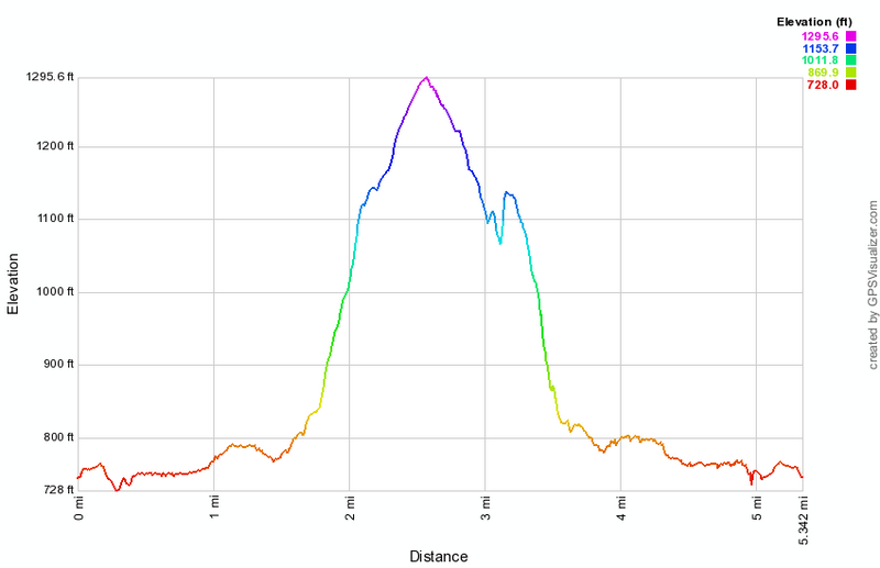
(The image at the left shows the profile of the hike.)
Shawangunk Ridge Trail: Guymard Turnpike to Hawthorne Lake
| Quick Look | |||
|---|---|---|---|
| Difficulty | Round trip | Total climb | Internet Maps |
| 10.4 mi. | 1794 ft. | AllTrails | |
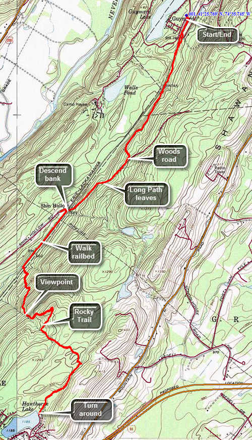 Drive to the hamlet of Godeffroy on Route 209 about 5.5 miles north of Port Jervis. Watch for the Guymard Turnpike on the east side of the road. Turn onto the turnpike and drive about .7 miles to a T. Turn right to follow the turnpike as it ascends and passes by one end of Guymard Lake. In about .2 miles park on the left side of the road. The train tracks are active so look and listen before crossing to the other side to pick up the Shawangunk Ridge Trail. Once you cross the tracks look for the aqua blazes of the Long Path on the left side of the right-of-way just before the underpass. Follow the trail down to a ditch and then up and across the Guymard Turnpike. Enter the woods on the other side of the turnpike. From this point on the trail rises and falls a little as you walk through both hardwood and softwood forest. Areas of the trail can be muddy and there are several small streams to cross and a few small "ponds". At 1.6 miles you will come to a woods road where you should turn right. Posted signs on both sides of the trail are a reminder to stay on the trail. At one point the Long Path cuts off to the left and the blazes change from the aqua Long Path blazes to the dark blue of the SRT. At 2.3 miles you will come to an old wooden bridge over the tracks and the trail blazes indicated a right turn. The bridge has been condemned and one look will tell you why! The trail descends the bank on the right side of the bridge. At the bottom turn left and walk along the right-of-way. The trail cuts into the woods near a stream at about 3.1 miles. Turn left and immediately start the biggest ascent of the day. Over the next .8 miles the trail climbs about 600 feet through several switchbacks and areas of very challenging trail. At times it seems you are walking in a rocky stream bed. At 3.6 miles there is an open rock face which serves as a nice lookout. You are now in Huckleberry Ridge State Forest. After finishing the climb there is a slight descent and then another ascent. There is one area of puncheons that can be very slippery. At 5.25 miles you will break out of the woods into the parking area near Hawthorne Lake. Just before the parking area is an unmarked trail to the right that goes near the shore of the lake. This is an out and back hike so turn around and retrace your steps when you are ready.
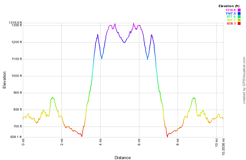
(The image shows the profile of the hike.)
Mountain Road to SRT
| Quick Look | |||
|---|---|---|---|
| Difficulty | Round trip | Total climb | Internet Maps |
| 3.6 mi. | 700 ft. | AllTrails | |
 Take exit 113 off Route 17/I86 to get on Route 209 south toward Port Jervis. Drive south to the Guymard Turnpike which is a sharp left turn about 1.7 miles south of the junction with Route 211. Follow the winding road over the ridge to Mountain Road. Turn right on Mountain Road and drive 3 miles south to the trailhead on the right. Park slightly south of the beginning of the trail where there is a pullout that can accommodate three or four cars. Walk north along Mountain Road and through a break in the fence. The trail begins as a wide woods road and starts a gentle climb for the first .4 miles. Passed a gravel pit on the right and watch carefully for aqua blazes which are sparse. After .4 miles there is a small pond with a concrete dam impounding the water. A white blazed trail crosses the dam at this point. From the pond continue on the Long Path heading first northeast and then northwest. The trail begins a gentle descent. At .9 miles there is another small pond. Just after this pond make a 90 degree turn to the left still following the Long Path. At 1.2 miles there is yet another pond where you will find the other end of the white trail. The Long Path begins to descend still following woods roads. Over the next .7 miles the trail descends a little over 350 feet until it intersects the Shawangunk Ridge Trail. "Tag" the SRT and then turn around to head back to the car. Ascend the ridge and at 2.7 miles you will be back at the last pond. You may continue to follow the Long Path back to the car. For some variety, turn right and start to follow the white trail. It also follows a road and from it you can see the Long Path as the trails are parallel at times. Cross a gas pipeline right-of-way and arrive back at the first pond you visited. The white trail turns left here and passes over the dam to rejoin the Long Path. Walk back down the woods road to Mountain Road and turn right to get back to the car.
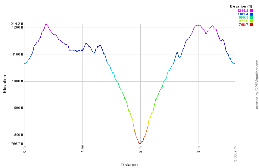 (The image shows the profile of the hike. Remember that all vertical profiles are relative!)
Hartley Road to Mountain Road
| Quick Look | |||
|---|---|---|---|
| Difficulty | Round trip | Total climb | Internet Maps |
| 14.8 mi. | 1360 ft. | AllTrails | |
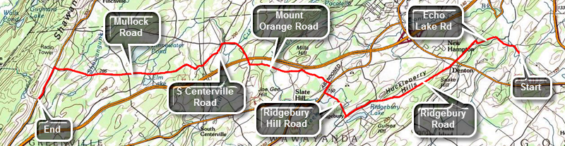 This route is a one way hike from east to west. This requires a you to spot a car at the end or get a ride. The 29.6 mile roundtrip would be difficult! Take exit 113 off State Route 17 to get on Route 209 south toward Port Jervis. Drive to the Guymard Turnpike and turn left to follow the winding road over the ridge to Mountain Road. Turn right on Mountain Road and drive 3 miles south to the trailhead on the right. Park slightly south of the beginning of the trail as there is a pullout that can accommodate three or four cars. Drop a car here. Drive to Hartley Road just west of Goshen. The easiest way to do this may be to drive south on Mountain Road to I84 and then take I84 to Middletown. From Middletown take Route 17 east to the Fletcher Street exit, exit 126. Turn right and right again onto Cheechunk Road. Drive about 1.7 miles west to Hartley Road. Turn left to the Heritage Trail pulloff only a few hundred feet in on the right. Start by hiking north on Hartley Road to Echo Lake Road. Turn left on Echo Lake Road and head west. After a short distance, cross over the Walkill River and pass Echo Lake at .75 miles. At 1.2 miles continue turn left slightly onto CR 50 heading west. Pass by the Waywayanda Inn and at 2 miles crossed Route 6. From this point on the road rolls some but overall gains elevation most of the time. After Route 6, cross Denton Hill Road and stay right on Ridgebury Road. The walk on Ridgebury Road is close to 3 miles to the intersection with Ridgebury Hill Road. Turn right at just over 5 miles and watch for the left turn onto Wilcox Road. Wilcox Road is only about .2 miles long and then the trail is back on Ridgebury Hill Road. Despite the fact that this is a road walk the blazes are there and pretty easy to spot. Continue north on Ridgebury Hill Road until it meets Route 6 where you turn right. Walk north on Route 6 for about .25 miles before turning left on McBride Road. At the end of McBride Road turn left on CR 49 and then almost immediately right on R. Hunter Road. Within a short distance R. Hunter Road becomes Mount Orange Road. The further west you hike the more rural the area becomes and the more elevation you gain. After about a mile Mount Orange Road turns sharply right and crosses over I84. Continue north and then west on Mount Orange Road until about 9.4 miles where the trail turns left onto Remey Road. The walk on Remey Road is short as it soon meets South Centerville Road that heads south and west to 10.1 miles. Continue straight ahead on Mullock Road which begins a nice climb ! Houses get farther apart and there are fewer cars. Mullock Road seems to go on forever as it gains elevation heading west toward Mountain Road. It crosses several roads on the way and passes an old cemetery. At 13.9 miles turn left onto Mountain Road for the final .9 miles back to the car.
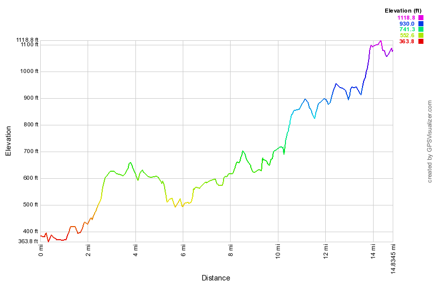 (The image shows the profile of the hike. Remember that all vertical profiles are relative!)
Heritage Trail
| Quick Look | |||
|---|---|---|---|
| Difficulty | Round trip | Total climb | Internet Maps |
| 11.6 mi. | 360 ft. | AllTrails | |
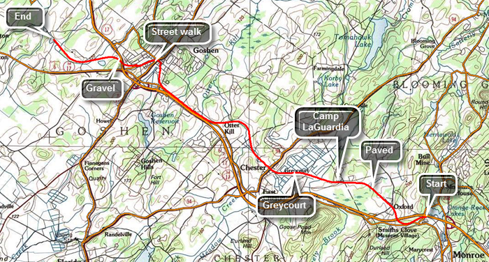 This route is a one way hike from east to west. This requires a you to spot a car at the end or get a ride. The 23.2 mile roundtrip would be difficult.Take the Fletcher Street exit, exit 126, off Route 17 heading east. Turn right and right again onto Cheechunk Road. Drive about 1.7 miles west to Hartley Road. Turn left and park at the Heritage Trail pulloff only a few hundred feet in on the right. Drop a car here. Drive back out to Route 17 and take exit 129. Park in the Heritage Trail parking lot on the right before the large commuter lots on the left. The trail starting in Monroe is a hard paved surface which makes walking it very easy. Throughout the walk you will meet other people who are walking and running some with their dogs. You will also meet people on bicycles. Everyone seems very respectful of the other people using the trail and many use it several times a week. Within .75 miles the trail passes under Route 17. Shortly after that there is a small cemetery nestled between the trees on the right side of the trail. It acts as a reminder that this area of Orange County has been settled for some time. There isn't much indication that the trail was once a railroad bed except where the trail crossed over another road. In several, places the tracks and original bridge are still intact. At about 1 mile the farmlands begin and you can catch glimpses of the countryside through the trees. You can still hear the noise of traffic but the atmosphere is very rural. Around 2.5 miles the trail passes by Camp Laguardia but most of the building are hidden by the high bank on the left side of the trail. There is also some fencing at various points along the route. Around 3.8 miles you will see the flat open fields of a black dirt region on the right or north of the trail. Just before the trail enters the village of Chester there is a railroad siding at Greycourt. A signboard tells the history of the area. As you enter Chester, there is an old railroad station on the left. The next section of trail is a little more than 4 miles and ends in Goshen. There is a lot of farmland on both sides of the trail. There are also three different marble benches dedicated to various people along the way. Where the trail crosses several roads traffic usually stops for pedestrians in the cross walk. There is even a portable toilet at one intersection. The village of Goshen is 8.5 miles from Monroe. Turned right on St. James Place and then left onto South Church Street. Continue on South Church and turn left on West Main after crossing Route 207. Keep looking for the aqua blazes on poles and signs. About .5 miles from South Church there is a large cemetery and the turn to the left is clearly marked with aqua blazes. Followed the blazes across the street and down a lane to the beginning of the last section of the Heritage Trail. From the village of Goshen to its end on Hartley Road, the trail is "paved" with crushed stone or it is simply packed earth. There are fewer people using this section. Pass under Route 17 at about 9.65 miles and continue on the flat, straight section. The predominant view on either side of the trail is a series of ponds and wetlands. There is one sign indicating that the Audubon Society maintains a bird sanctuary in the area. There is one final bench near the bird sanctuary with no dedication. After this it is a quick walk to Hartley Road.
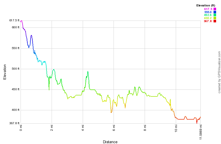 (The image shows the profile of the hike. Remember that all vertical profiles are relative!)
Route 32 to Heritage Trail
| Quick Look | |||
|---|---|---|---|
| Difficulty | Round trip | Total climb | Internet Maps |
| 8.7 mi. | 1832 ft. | AllTrails | |
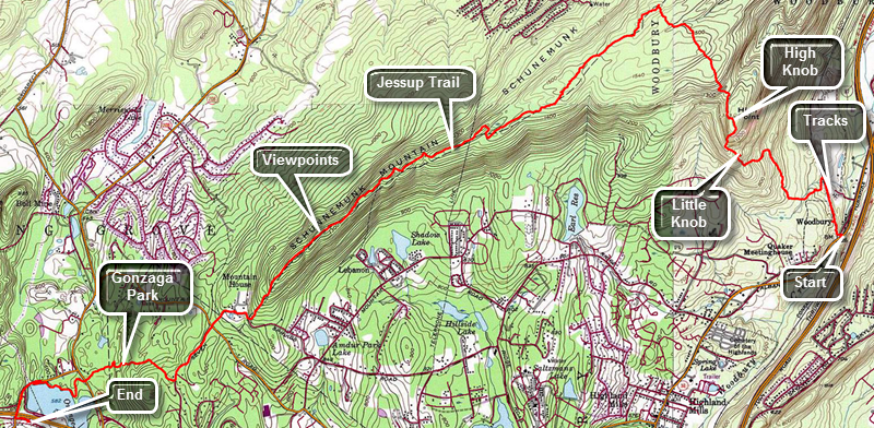 This route is a one way hike from east to west. This requires a you to spot a car at the end or get a ride. The 17.4 mile roundtrip would be VERY difficult.Drop a car in the Heritage Trail parking area at exit 129E off Route 17. Drive another car or get a ride to the beginning of the hike. Take the last exit before the Harriman toll plaza heading south and east on Route 17. Take Route 32 north about 4 miles through the hamlet of Highland Mills. Park at the corner of Evans Drive and Highland Mills. Walk .2 miles north and east on Route 32 being very careful as the road is heavily traveled. Turn left just after you walk under the railroad trestle and watch for some stone steps that ascend to the railroad tracks and right-of-way. Walk about .4 miles along the tracks. It is easier to cross to the opposite side of the tracks where there is a much smooth surface. Watch the aqua blazes and turn off the tracks onto a woods road. At .8 miles the aqua blazes point to the right as the trail turns off the woods road. The trail now begins an ascent that ends on the Schunnemunk Ridge. The trail heads generally northwest with some detours around cliffs and ledges. At 1.4 miles there is a lookout dubbed Little Knob. There are some good views to the south and east. The next climb is to the top of High Knob which has an elevation of over 1300 feet. The train trestle is at an elevation slightly below 500 feet. The trail now begins to climb very steeply with some sections requiring you to grab onto a root or pull yourself up over rocks. As you climb watch for views to the west and north. The primary view in the foreground is Kiryas Joel, an ultraorthodox Jewish community. At 1.7 miles reach the top of High Knob and where the views are breathtaking! The views are expansive in almost all directions. Back on the main trail start down off High Knob. The trail is sited along the edge of High Knob and drops only about 100 feet before starting to climb again to the ridges. At 2.75 miles the Long Path meets the yellow Jessup Trail on the main Schunnemunk Ridge. On your trip up the ridge there are several other paths and trails that cross the Long Path including the Woodbury Park Trail which is still marked with faint red blazes. You will also cross Dark Hollow Brook walking through hardwood forests with a predominance of oak trees. Turn left on the Jessup Trail being careful to avoid the orange blazed Western Ridge Trail. Over the next 3.6 miles the trail heads southwest. Most of the time you will be descending and any ascents are short. The trail is well-maintained and the further you go the more it looks like a woods road. The state park ends at about 3.4 miles and you will soon pass an antennae park. From that point on there are very limited views to the east but excellent views to the west and north. One viewpoint has a picnic table and fire ring. The Catskills and Shawangunks are clearly visible. The yellow blazes are easy to follow but someone has added fluorescent green paint which is even more visible! At 6.4 miles the rail meets paved Seven Spring Road and turns right and then quickly left. It is a short walk to a gate and Gonzaga Park. This park is being developed by Orange County. It was originally the site of the Seven Springs Mountain House in the early 1900's. It was a popular retreat for vacationers and later became the Gonzaga monastery and catholic retreat center. All that remains today the well enclosure, a large octagonal chapel once attached to the monastery and a smaller chapel in the woods. Walk down to the entrance to the park and cross Seven Springs Mountain Road. Watching for the blazes on the road and the point where they make a right turn into the woods at 7.1 miles. The hike is not completely flat after this turn and there were still some small ups and downs on the way to Route 208. There were many well-constricted stone walls in the area and some foundations from an old homestead very close to Route 208. Cross the road at 7.8 miles and walk about .2 miles to the shores of Orange Rockland Lake. Along the way you will have to negotiate a few ledges and one steep but short descent. Turn right at the lakeshore to follow the trail to Museum Village Road. Turn left on the road and follow it until you cross over Route 17. Turn left and walk back down to the parking area. This the final section is only about .4 miles.
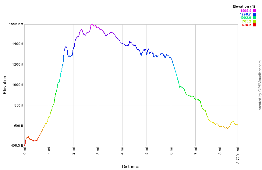 (The image shows the profile of the hike. Remember that all vertical profiles are relative!)
Lake Massawippa to Route 32
| Quick Look | |||
|---|---|---|---|
| Difficulty | Round trip | Total climb | Internet Maps |
| 13.5 mi. | 1430 ft. | AllTrails | |
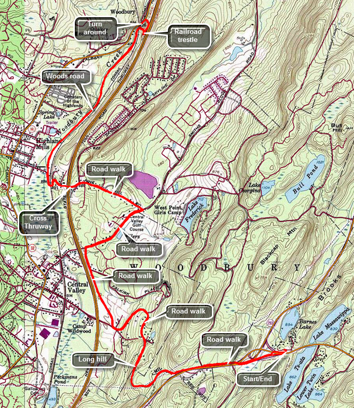 Take I86, the Quickway, to the exit just before the Harriman toll plaza and get on Route 6 East. Drive 3.8 miles to the parking area on the left just before Lake Massawippa. You may also take Route 6 West from the Bear Mountain traffic circle and the parking area will be on the right just after the lake. Walk out to Route 6, carefully cross the road and walk for a half mile on the shoulder of Route 6. Just passed the intersections with Route 293 cross the road and walk into the woods. Watch for a trail and the aqua blazes of the Long Path. Turn left and follow the trail as it parallels Route 6. At .8 miles the trail comes out of the woods to the shoulder of Route 6 and at about 1 mile it turns right and begins a long downhill section at the point where the guardrail begins. Walk downhill on a track or path and pass through a gate in a fence. Almost immediately you will be on an old, abandoned road heading north. You may get views of the Woodbury Commons shopping center and Monroe-Woodbury High School. This road starts as Old Route 6 and then is marked as Estrada Road. At about 1.7 miles there is a chain across the road and a turnaround. Some descriptions give this as a parking area but there are several "official" signs that said "No Parking"! Walk down Estrada Road following the aqua blazes. At 2.6 miles at the bottom of the hill and just before crossing the Thruway, turn right on Abrams Road which runs parallel to the Thruway. Traffic here is usually minimal and the shoulder is wide enough to walk on. At 3.3 miles turn right onto Smith Clove Road and walk about .6 miles northeast. This road has almost no shoulder at the beginning and traffic can be heavy. Watch for some very expensive houses and a large, well-maintained golf club. At 3.9 miles turn left on Pine Hill Road and walk .7 miles until you cross over the Thruway. Continue to descend Pine Hill Road passing through an underpass under the Metro North tracks. At 4.9 miles the road turns left but you should continue straight ahead onto a woods road. The woods road is wide and open and acts as a right-of-way for a gas pipeline. The road travels along Woodbury Creek and the trip is pretty. Except for the traffic noise from the Thruway the setting could be mistaken for anyplace in the Catskills. The road swings to the northeast and then back north for about 1.5 miles. It is very flat. At 6.45 miles walk under a railroad trestle and near Woodbury Creek. Just after walking under the trestle, turn right heading east and walk up a steep bank to a fence. Walk around the end of the fence and turn left. Walk along it for about .1 miles when the trail will bring you out to the berm that runs along the shoulder of the Thruway. Walk north along the berm for a hundred feet and then turned left into the woods. Follow the aqua blazes over a fence and down a steep bank to Route 32. At the road turn left, walk across a bridge over the creek and stop just short of the trestle. Look across the road at a drive way and find a "Long Path" sign and aqua blazes on the other side. This is your turnaround point since the next section starts here. To get back to the car, turn around and retrace your route.
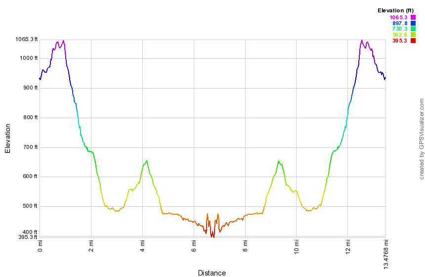 (The image shows the profile of the hike. Remember that all vertical profiles are relative!)
Harriman: Turkey Hill to Route 6
| Quick Look | |||
|---|---|---|---|
| Difficulty | Round trip | Total climb | Internet Maps |
| 7.2 mi. | 1887 ft. | AllTrails | |
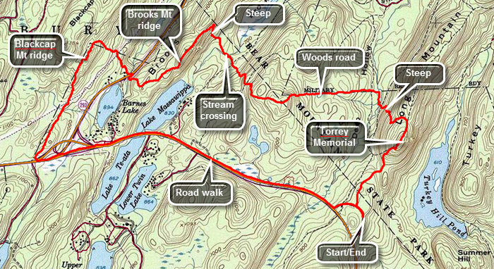 Take I86, the Quickway, to the exit just before the Harriman toll plaza and get on Route 6 East. Drive a little more than 4 miles to the parking area on the left where the Long Path crosses the road. You may also take Route 6 West from the Bear Mountain traffic circle for less than a mile. In this case the parking area is on the right. From here the Long Path heads northeast toward Long Mountain and passes the Torrey Memorial on the way. Raymond Torrey was a founding member of the new York New Jersey Trail Conference and instrumental in the creation of the Long Path. The first part of the trail descends and crosses the Popoloppen Torne Trail. Stay on the Long Path and start a short ascent up a hill. The trail flattens out at the top at around .7 miles is the memorial with a message carved into the exposed bedrock. The views are good and you see the Perkins Tower on Bear Mountain. Turkey Hill Lake lies below with its rocky but secluded shores. Continue following the aqua blazes and over the next half mile drop 420 feet as the trail descends the steep side of the ridge. Several switchbacks moderate the grade but it still averages 15%. When a layer of damp leaves covers the slippery rocks a quick descent is impossible. At about a mile the well-worn track seems to go straight ahead but the trail turns to the right. Near the bottom of the descent cross a stream by hopping from rock to rock which is easy when the water level is low. There is a "bridge" present but it has seen better days. The construction consists of two logs that were cut on site to span the stream. The "decking" is made of branches lashed to the logs with very old rope. At 1.25 miles the trail turns to the left and starts to travel due west on what looks like a right-of-way or woods road. On the right are signs indicating that the land is part of the West Point Military Reservation. Start an ascent of 470 feet over .66 miles to the top of Howell Mountain. Near the top of the ascent is a rock outcropping where large cubical blocks of rocks have split off. As you begin to descend the 430 feet from Howell Mountain you can see the next ridge. The descent has a few switchbacks to help where the slope is the steepest. At the bottom of the descent cross the outlet stream to Lake Massawippa on large stepping stones placed by a trail crew. The Brooks Mountain ridge lies ahead and hiking directly up the ridge would have mean gaining over 200 feet in about 400 feet! Fortunately the trail turns north to ascend on a shallower slope and then turns southwest in a major switchback at about 2.8 miles. The trail picks up a woods road that gently ascends the ridge to the summit at 1080 feet. There are only limited views from the top. Descend off the ridge heading southwest until at 3.6 miles you come to Route 293. Along the way the trail shifts direction turning to the northwest. Walk up to the road passing a culvert that directs Popolopen Creek under the pavement. Cross the road and face another ascent up the Blackcap Mountain ridge. Blackcap Mountain has a maximum elevation of 1381 feet but the trail turns southwest at less than 1200 feet. Continued to walk through hardwood forest and begin the climb up the ridge. At 4 miles and about 1180 feet the trail turns 90 degrees and heads southwest again along the base of the ridge. For about a mile the trail is straight as an arrow heading southwest toward Route 6. There are some ups and downs in the trail but nothing compared to the ridges you have already crossed. The trail does not actually intersect Route 6 but as you near the road it is easy to walk out to the pavement. Cross Route 6 and eventually Route 293 as well. The traffic can be very heavy but the shoulders are wide. At 5.6 miles Route 6 passes between Lake Massawippa and Lake Te-Ata. Continue on Route 6 back to the parking area on the left.
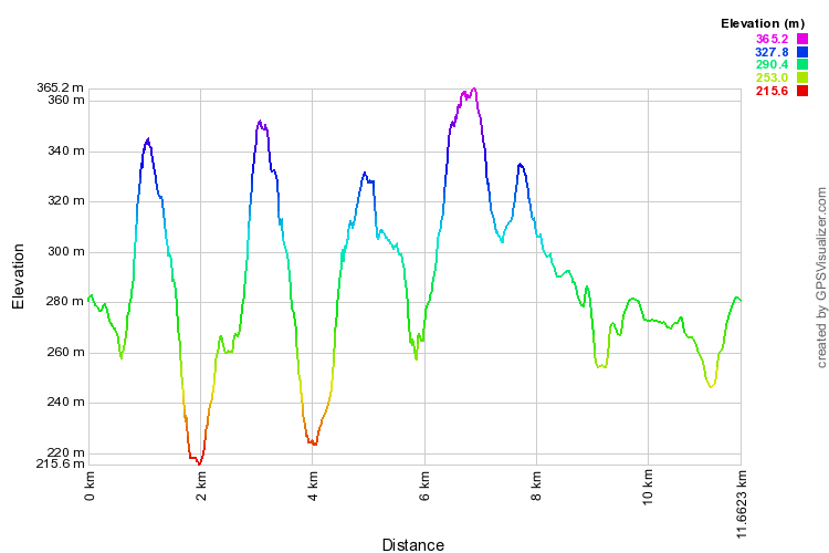 (The image shows the profile of the hike. Remember that all vertical profiles are relative!)
Harriman: Long Path to 1779 Trail Loop
| Quick Look | |||
|---|---|---|---|
| Difficulty | Round trip | Total climb | Internet Maps |
| 10.9 mi. | 2170 ft. | AllTrails | |
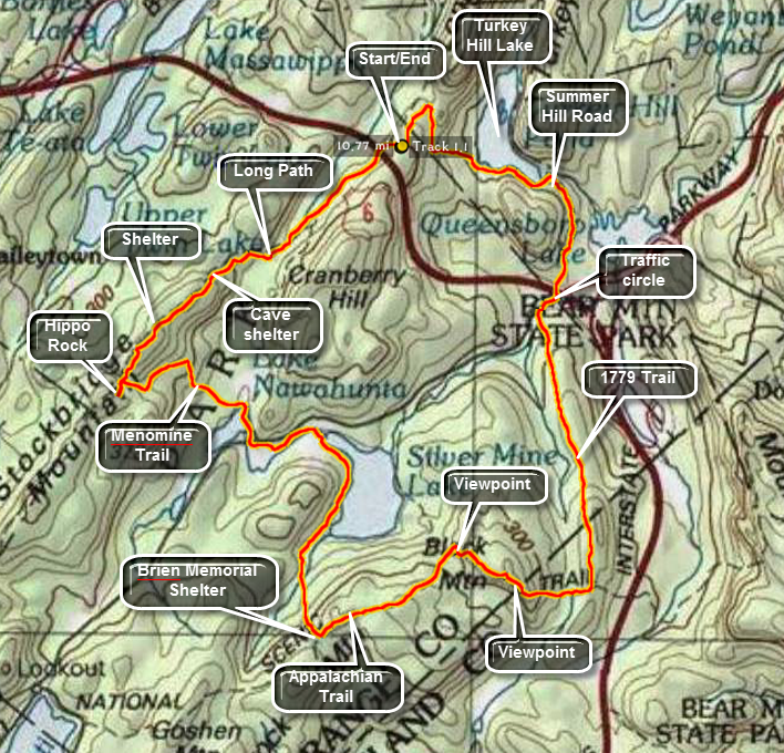 Take I86, the Quickway, to the exit just before the Harriman toll plaza and get on Route 6 East. Drive a little more than 4 miles to the parking area on the left where the Long Path crosses the road. You may also take Route 6 West from the Bear Mountain traffic circle for less than a mile. In this case the parking area is on the right. From here the Long Path heads northeast toward Long Mountain and passes the Torrey Memorial on the way. Walk out the exit for the parking area and across the road since this hike heads in the opposite direction. The Long Path crosses almost directly across from the exit to the parking area. The trail follows wide woods roads in many places. Be careful as you hike since there are many fire roads and other paths that crisscross the trails and it is easy to get lost even with a map. The Long path heads almost directly southwest and climbs around 400 feet in the first 1.8 miles. Just before another climb there is a series of rock overhangs which are labeled "cave shelter" on the NYNJTC maps. Climb to the top of the rise and walk along a flat part of the trail to a rock shelter at 2.0 miles. The shelter faces west and the map marks it as a viewpoint. Like so many of the places that were once viewpoints the trees have grown to block most of the view. Descend to the junction with the yellow Menomine Trail but continue straight ahead to Hippo Rock at 2.3 miles into the hike. This rock really does look like a hippo from the front. Head back to the trail junction and turn right on the yellow Menomine Trail heading generally southeast. The trail is a long descent along a woods road and soon you will pass Lake Nawahunta. At 3.6 miles cross Seven Lakes Drive and head toward Silvermine Lake. Walk the trail along the west shore of the lake. Over the next .6 miles the trail gains 320 feet to the site of the Brien Memorial Shelter. The shelter is about 5.3 miles into the hike. Turn left onto the Appalachian Trail and starting up a short, steep rock climb. This trail is marked in white for the AT but also has red blazes as it is part of the Ramapo Dunderberg Trail. After reaching the top of the rock scramble, the trail flattens some with a few ups and downs. For about .9 miles from the shelter the trail rolls up and down slightly until at 7.2 miles it turns to the right. Now you are hiking southeast rather than northeast and starting up Black Mountain. After a short but steep climb there is a viewpoint over Silvermine Lake. Continue on to the summit at 7.7 miles into the hike. The views here include the New York City skyline. From the summit start down a very steep descent of almost 400 feet in .35 miles. A little further on turn left and head almost due north on the blue 1779 Trail. The trail parallels the Palisades Parkway which is just over a ridge to the right. There are no views but the 1.6 miles to Seven Lakes drive near the Long Mountain traffic circle is pleasant enough. At the traffic circle cross the road and head directly into the woods. DO NOT walk further up the road as the trail there is not marked and it will take you out of the way. Find a marker on a tree and then look ahead across the construction yard for another on a pole! Walk to the back left corner of the yard a find the trail and the markers. Enter the woods to continue the hike. The trail heads north toward the Popolopen Gorge Trail and Turkey Hill Lake just skirting a climb up Summer Hill. After about .6 miles, you may walk straight ahead on Summer Hill Road rather than take the circuitous route on the trail. If you want to stay on the trail, turn to the right. Be sure to turn left at the next trail junction! Just before you cross a small stream look for the trail on the left. It may be hard to spot since it is marked for an approach from the opposite direction. Stay on the trail and you will soon be at the dam for the lake. Continue around the west shore of the lake which has several spots to stop and take pictures. From the dam it is all uphill for the next .9 miles until you hit the Long Path again at 12.2 miles. Turn left on the Long Path and hike the .3 miles back to the car.
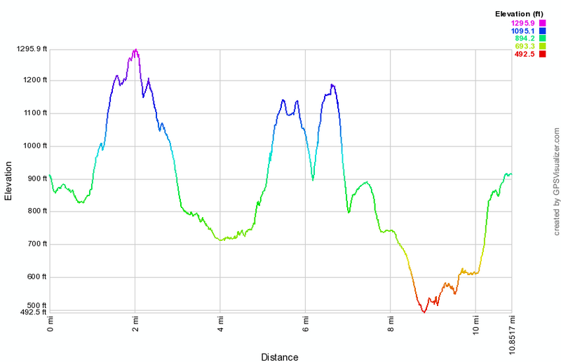 (The image at the left shows the profile of the hike. Remember that all vertical profiles are relative!)
Harriman: Lake Tiorati to Hippo Rock
| Quick Look | |||
|---|---|---|---|
| Difficulty | Round trip | Total climb | Internet Maps |
| 4.9 mi. | 1040 ft. | AllTrails | |
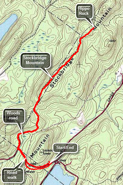
Take Seven Lakes Drive southwest from the Long Mountain Circle near Bear Mountain. At the Tiorati Circle turn right on Arden Valley Road and park in the parking area on the left. Walk up to the Arden Valley Road and head west and north on the road. Walk up and down the hill, to find the Long Path at the point where the road makes a sharp left. The aqua blazes are clear on both the rocks and trees. Turn right onto a wide woods road and walk passed a gate heading north and then north northeast. At 1 mile the trail turns to the north again and rises over the top of a ridge and descends down the other side. The forest is all hardwoods and very open. As you come down off the first, small ridge you enter the area between two ridges. It is very rocky as is typical of Harriman. Begin to climb up the Stockbridge Ridge to Stockbridge Mountain. The climb looks steep on the profile but is only about a 10% grade. At the top of the mountain is a flat, open area with a limited view. Descend from Southbridge Mountain still heading north and continue north along the trail as it rolls some. Hippo Rock is a large and precariously balanced glacial erratic on the left side of the trail. As you descend a hill at 2.5 miles the rock will be directly ahead and is unmistakable. When you are done at the rock, turn around and retrace your route back to the car.
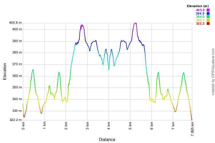 (The image shows the profile of the hike. Remember that all vertical profiles are relative!)
Harriman: Lake Tiorati to Lemon Squeezer
| Quick Look | |||
|---|---|---|---|
| Difficulty | Round trip | Total climb | Internet Maps |
| 7.1 mi. | 1700 ft. | AllTrails | |
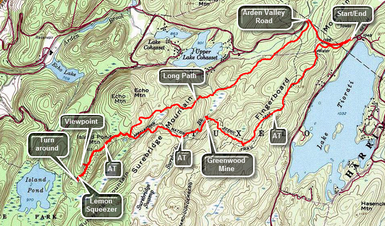
Take Seven Lakes Drive southwest from the Long Mountain Circle near Bear Mountain. At the Tiorati Circle turn right on Arden Valley Road and park in the parking area on the left. Find the blue blazed Tiorati Trail that leaves the parking area heading west and roughly parallelling Arden Valley Road. After about .3 miles, the blue trail ends at the AT and Ramapo-Dunderberg Trail. Turn left and follow the trail blazes. Almost immediately you will pass by a new steel water storage tank on the right and the old cement and wooden cistern on the left. The trail begins to climb to the top of the Fingerboard Mountain Ridge. The trail generally ascends and you will hit 1375 feet at the highest point which is a little more than 400 feet higher than the parking area. You can see Lake Tiorati below if there are no leaves on the trees but there is never a good enough vantage point to take pictures. The trail surface is typical for Harriman with areas of open rock faces alternating with jumbles of rocks and a few clear areas between! Watch for the numerous glacial erratics that litter the park. There ware three small but interesting "pink" boulders in one area which may be "pinks schist". At 1.3 miles you will be at the highest point of the ridge you will then drop almost all the elevation you gained as you hike downhill to Surebridge Brook. Do not cross the brook here but turn left to follow the AT along the brook. Watch for the tailings piles from the Greenwood Mine. The Harriman area is full of iron mines that date back as far as the period of the American Revolution. Some are just small pits while others like the Greenwood Mine are much bigger. Most of the Greenwood Mine is now underwater but the main adit and the tailings are visible along the trail. There is another large adit up on the hillside. Continue on the AT until it crosses the brook at 2.2 miles. Ascend a small hill and then walk back down the other side to the junction with the Long Path at 3 miles. Continue on the AT and begin the steepest climb of the day to the top of Island Pond Mountain. As you descend the other side watch for a nice lookout off to the right that has a beautiful view of Island Pond. Walk back to the trail and down the other side of the mountain to the area of the Lemon Squeezer. The Lemon Squeezer on the AT in Harriman is one of at least four that I know of and each is different and interesting in its own right. You will come to a point on the AT where there is a sheer drop of at least 10 feet with only a few handholds. You may try this descent or opt for the easy way which is marked by a sign that says ... "Easy Way"! Work your way back over to the Squeezer which is a narrow slot that you have to walk through. Walk back through the Squeezer and return to the junction with the Long Path. You will have to climb up and over Island Pond Mountain again. At 4.5 miles turn left or northeast on the Long Path. For the next 2.1 miles you will struggle over some very rocky terrain. Along the way you will hike up and down at least three hills. Nothing is very steep or very high but the constant hike over the rocks begins to become uncomfortable. Finally at 6.6 miles you will hit the Arden Valley Road. Turn right and walk on the flat, hard surface up a hill. Simply stay on the road and walk back to the car at the Lake Tiorati Circle parking area.
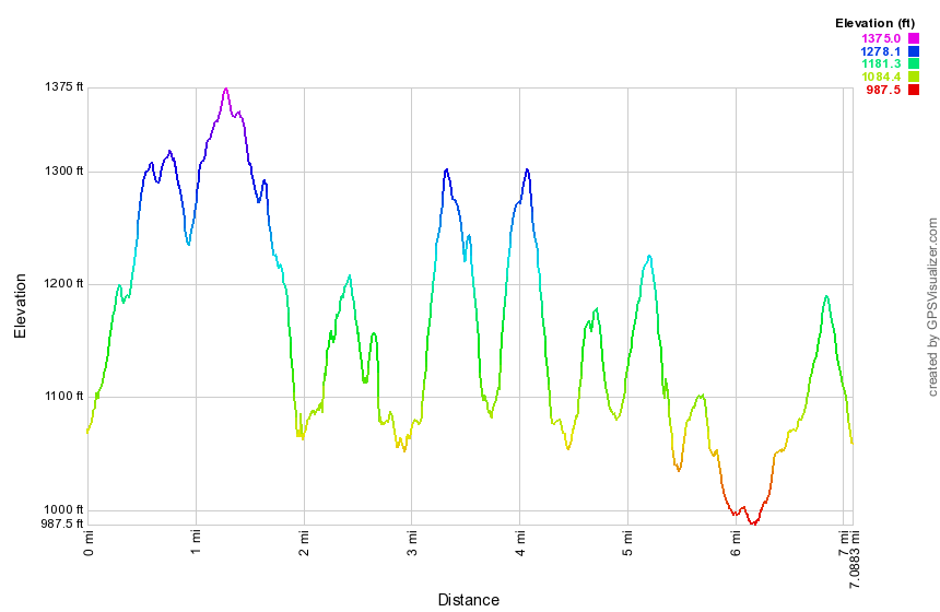 (The image at the left shows the profile of the hike. Remember that all vertical profiles are relative!)
Harriman: Route 106 to Elk Pen
| Quick Look | |||
|---|---|---|---|
| Difficulty | Round trip | Total climb | Internet Maps |
| 9.3 mi. | 1936 ft. | AllTrails | |
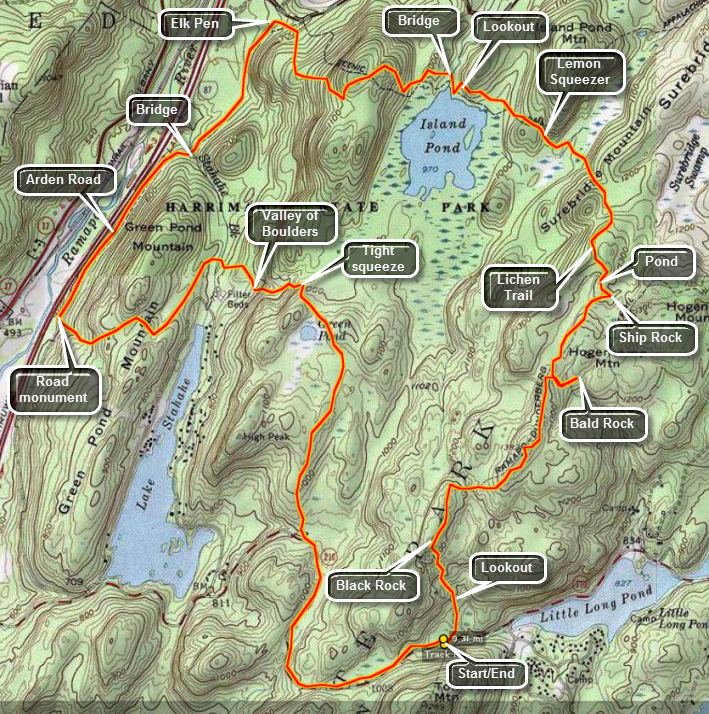
Take Seven Lakes Drive southwest from the Long Mountain Circle near Bear Mountain. Pass through the Tiorati Circle staying on Seven Lakes Drive. At the Kanawauke Circle take Route 106 west passing between the two parts of Lake Kanawauke. The next body of water on the left is Little Long Pond. Just passed Little Long Pond on a slight upgrade will be a parking area on the right for up to ten cars. There are no trailhead markers but this is the place to park. After parking walk into the woods straight ahead and watch for the red markers of the Ramapo-Dunderberg Trail.
Hike through some tress to an area with enormous and impressive rock formation. Hike up and through these formations for about .25 miles until you are on an exposed rock face with a good view of the surrounding terrain and the hills in the distance. Get back on the RD and hike across the rocky spine surrounded by a few trees. After another .25 miles you will be at Black Rock which also gives nice views. As you hike keep looking for the best views since they aren't always at specific named places along the way. In about .8 miles you will be at the Bald Rocks in an open area where many glacial erratics lie on top of strangely marked bedrock. Just after this area the yellow Dunning Trail turns left to Hogencamp Mountain and the Hogencamp Mine. To the left the trail leads to the White Bar Trail and on to the Nubian Trail near Valley of the Boulders.
Continue on the RD passing Hogencamp Mountain on the right. After ascending some open slabs of rock, take in the nice views of the immediate area, the hills and valleys afar and the little pond just below. bear right on the Rd and descend off the ridge for just a short distance. Ahead and slightly to the left will be a large glacial erratic sitting among some trees. Use you imagination to see the prow of a ship sailing into the forest. This is Ship Rock. You can continue on the RD to Times Square and return on the Arden-Surebridge Trail. It may be easier to retrace your steps back to the open rock faces and turn right on the Lichen Trail marked with a blue L on a white background. This trail has some nice viewpoints and is worth the walk. Keep a careful watch for the markers as they may be hard to spot. The Lichen Trail is only about .4 miles long. It passes over a rocky outcrop and then drops around it before rising over more open rock faces. At this point Island Pond can be seen at a distance on the left. At the bottom of a short, steep descent turn left on the red marked Arden-Surebridge Trail which runs concurrently with the aqua blazes of the Long Path.
In .8 miles you will hook up with a section of the white blazed Appalachian Trail just passed the Lemon Squeezer. Before this trail junction are several others that can mislead and confuse. An unmarked trail named the Bottle Cap is the first to appear on the right. Just a few hundred feet later the aqua blazes turn right as the Long Path leaves to the north. In this same area the white blazes of the White Bar Trail appear on the left. Stay on the red trail to an area where you will see some tight passages between the rocks. This is the Lemon Squeezer, The trail does not actually pass through the Lemon Squeezer but feel free to examine this area and walk through the tight "canyons". Just after this the red blazes turn abruptly left as the A-SB Trail turns south. Continue straight ahead on the Appalachian Trail as it works its way passed Island Pond. You will want to get a better view of this little pond but each potential viewpoint is blocked by trees. Stay on the AT as it descends to a flat area just above the pond. Walk to your right to a rock ledge and a beautiful view of this body of water. Return to the AT and cross the outlet of the pond on a small wooden footbridge. Observe the stonework that seems to form a sluice out of the pond.
The AT then ascends form the pond outlet and snakes its way over Green Pond Mountain. The ascent and descent have a few steeper areas but the switchbacks take car of most of these. As you start to descend, you may notice the sounds of traffic. At this point you are headed toward the Elk Pen which is adjacent to the New York State Thruway. After 1.4 miles on the AT and at the bottom of the hill near the Elk Pen turn left on the Arden-Surebridge Trail which runs along the surface of the old Arden Road once called the Harriman Flat Road. In .3 miles the A-SB turns left but you should continue straight ahead on the Stahahe Brook Trail and the Arden Road. After another .3 miles, this trail turns left into the woods just after crossing Stahahe Brook. Stop at the bridge to enjoy the sights and sounds of the brook running under the bridge. Bear right to stay on the Arden Road which now parallels the Thruway for .85 miles. At this point a marker commemorates the road and the builder by stating "showing the advantages of building flat roads in hilly country". Just after this memorial are the white marks of the Nurian Trail which will lead all the way back to the parking area. This trail crosses the Thruway on a raised overpass!
The Nurian Trail now climbs back over the Green pond Mountain Ridge and has a few challenging areas. In .8 miles it crosses Stahahe Brook on a double bridge where the Stahahe Brook Trail enters from the left. Be sure to bear right in this area turning east and southeast on the Nurian Trail. Within .25 miles the trail ascends slightly and then descends into a boulder strewn stream bed. This is the Valley of Boulders and is impressive for the number and variety of large rocks. the trail ascends steeply out of the valley but several switchbacks eliminate all but a few sharp climbs. In one area the trail ascends passed and through some large rock formations. The trail ascends some and joins several woods roads and other trails including the White Bar and Dunning Trails. The Nurian Trail will lead back to the RD just south of Black Rock. You can take the RD back to the parking area by retracing your steps. You may also turn right on the wide Island Pond Road as it come up on your right. After about 1 mile on this road you will be at Route 106. Turn left on the road and walk 1.2 miles back to car. Along the way you will notice a large parking area on the right for the White Bar trail as it turns south. This is the ONLY parking area with any signs or trailhead markers. Several more parking areas or pulloffs will be on the left.
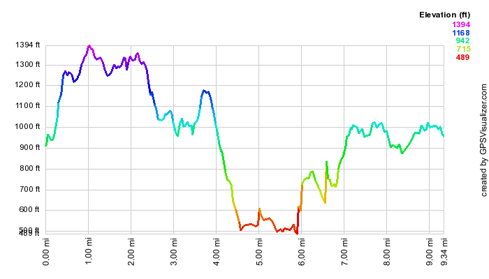 (The image at the left shows the profile of the hike. Remember that all vertical profiles are
relative!)
(The image at the left shows the profile of the hike. Remember that all vertical profiles are
relative!)
Harriman: Lake Skanatati to Pine Swamp Mountain
| Quick Look | |||
|---|---|---|---|
| Difficulty | Round trip | Total climb | Internet Maps |
| 5.6 mi. | 980 ft. | AllTrails | |
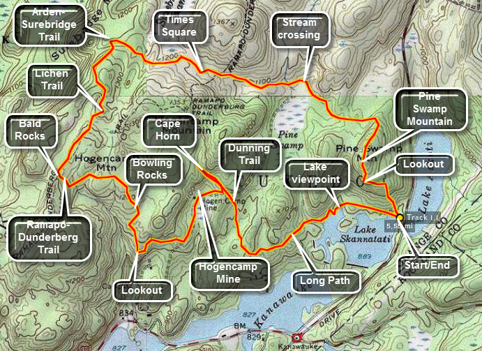
Take Seven Lakes Drive southwest from the Long Mountain Circle near Bear Mountain. Pass through the Tiorati Circle staying on Seven Lakes Drive. Just passed Lake Tiorati there are two lakes, one on each side of the road. These are Lakes Askoti and Skanatati. Pull into the parking area on the right next to Lake Skanatati. This lake is larger than it looks as you will see when you hike along the shore and see it from above. The trails start to the right of the lake. Bear to the left on the Long Path marked with aqua paint. As you walk along this path there are several opportunities to walk down to the lake to get a better view. After following the shoreline of the lake the Long Path continues west and then turns north. At 1.1 miles the Long Path meets the yellow marked Dunning Trail.
Continue north on the Long Path for about .2 miles. The trail ascends gently passed some really impressive rock formations and a cold mountain stream. Continue up the trail until you see a pair of glacial erratics on a hill above you. There was extensive mining in this area and you may see the opening of mine adits, mine pits and equipment. Turn around and hike back to the junction with the Dunning Trail. Turn right and follow the Dunning Trail west .15 miles. In this area there are extensive tailings from the Hogencamp Iron Mines. There are also open pits and at least one adit. The trail continues south and then west for .45 miles before turning abruptly north. In this area, there is a nice lookout over Little Long Pond. This is a good place to stop for a rest before continuing north.
Take the Dunning Trail north as it ascends about .3 miles to the Bowling Rocks. Here there is a long narrow open rock face with several medium sized boulders. All that is needed are some "pins". Continue walking another .35 miles to the Bald Rocks and the junction with the Ramapo-Dunderberg Trail. The Bald Rocks can be accessed from an unmarked trail just before the RD junction or turn left on the RD and walk up a slight incline to the Bald Rocks. At the trail junction turn right on the red marked RD Trail. This trail has many open rock faces some of which are flat but MANY of which are tilted. These areas can be slippery when wet, cold when windy and IMPOSSIBLE when icy. The trail descends into a swale with a small stream. There is a log bridge here. On the other side the trail ascends up a short rock scramble and then up an open rock face. The RD Trail goes up and over the top. At the top look down to you left to see a small pond often frequented by wildlife. Continue for several hundred feet on the RD Trail. Look straight ahead to see a large glacial erratic that looks a little like the prow of a ship. Return to the top of the rock outcrop and turn right. Watch for the blue L on a white background that marks the Lichen trail. The total distance from the Dunning-RD junction is about .35 miles.
The Lichen Trail runs to an elevated rock plateau and continues straight ahead off the plateau and down to the left. After wrapping around a rock outcrop to the right the trail ascends over...an open rock face. From this point is a nice lookout over Island Pond. The trail continues .35 miles along open rock and descends steeply down to the Arden-Surebridge Trail which is marked with red triangles. Turn right on the ASB Trail and continue over relatively flat but often wet ground for .45 miles to Times Square. This is a junction of four trails and a woods road. The trails are well marked but make sure you continue ahead and slightly to the right on the ASB Trail. This trail has its ups and downs as it continues .45 miles to the junction with the Dunning Trail. Pick your way across a stream that eventually empties into Pine Swamp and stay on the ASB Trail. South on the Dunning Trail are the remains of the Pine Swamp Iron Mine. This mine has an adit that can be entered in drier weather and a large stope.
The ASB Trail continues east for .5 miles and then turns directly south and starts to climb Pine Swamp Mountain. In .2 miles you will be at the top of the mountain. The climb is not difficult and proceeds along a wide woods road. From the top of Pine Swamp Mountain are several nice lookouts over the surrounding lakes. Directly south is lake Skanatati and just beyond the two part of Lake Kanawauke. Around to the left Lake Askoti is partly visible with Little Long Pond on the extreme right. After taking some time to enjoy the view and take pictures, get back on the trail and descend to the parking lot .35 miles away. This descent is steep in spots with one short rock scramble.
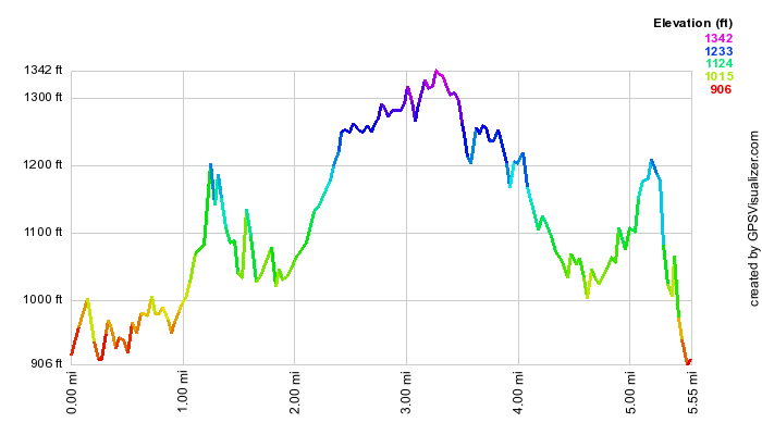 (The image at the left shows the profile of the hike. Remember that all vertical profiles are
relative!)
(The image at the left shows the profile of the hike. Remember that all vertical profiles are
relative!)
Harriman: Boston, Garfield, Greenwood, Surebridge Mines
| Quick Look | |||
|---|---|---|---|
| Difficulty | Round trip | Total climb | Internet Maps |
| 10.6 mi. | 1825 ft. | AllTrails | |
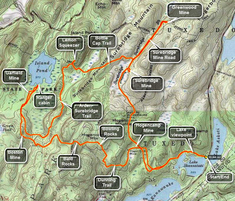
Take Seven Lakes Drive southwest from the Long Mountain Circle near Bear Mountain. Pass through the Tiorati Circle staying on Seven Lakes Drive. Just passed Lake Tiorati there are two lakes, one on each side of the road. These are Lakes Askoti and Skanatati. Pull into the parking area on the right next to Lake Skanatati. This lake is larger than it looks as you will see when you hike along the shore and see it from above. The trails start to the right of the lake. Bear to the left on the Long Path marked with aqua paint. As you walk along this path there are several opportunities to walk down to the lake to get a better view. After following the shoreline of the lake the Long Path continues west and then turns north. At 1.1 miles the Long Path meets the yellow marked Dunning Trail.
Bear left on the Dunning Trail past the workings of the Hogencamp Mine on the right. There is a swamp on the left and some tailings from the mine. The trail ascends a hill to an area that overlooks Little Long Pond. Continue up the hill to a long flat area of bedrock. There are several large boulders lying on the flat area. these are called the Bowling rocks. The trail winds down and up until it meets the Ramapo-Dunderberg Trail after about 1.2 miles. Just to the left up the RD Trail is the area known as the Bald Rocks. The exposed bedrock in this area has interesting striations. Continue on the Dunning Trail through this area.
In .25 miles the Dunning Trail meets and runs concurrently with the White Bar Trail for another .25 miles. At this point turn right to stay on the Dunning Trail. Stay on the Dunning Trail and in about .3 miles begin to look for mine tailings. This is the Boston Mine. There are two surface pits with their associated tailings. To find the Island Pond Road walk north or slightly northeast until you see the red triangles that mark the Arden-Surebridge Trail. Turn left on this trail and follow it until it meets the road. After several hundred feet the ASB Trail turns left. Continue on the road until it forks and take the left fork. The road appears to end but work your way through the laurel until you are almost at the lake shore. Here you will find an exploratory pit and a water filled trench. There are also some tailings from the Garfield Mine. Walk back out to where the road forks and take the right fork. This part of the road ends on the shore of Island Pond. The pond is beautiful and the ruins of an old stone ranger station can be found here.
Turn around and take the road back to where the ASB Trail meets the road. Turn left onto the trail. this trail heads southeast and then turns northeast as it heads toward the Lemon Squeezer about 1.6 miles away. The trail initially is relatively flat but then climbs to the top of a ridge. From here it goes up and down until the Lemon Squeezer. Stop here an spend some time investigating the lemon Squeezer. The AT ascends through this area but you will be returning to the ASB Trail after finishing at the Lemon Squeezer. Continue on the SB Trail and the Long Path for about .25 miles until the Bottle Cap Trail leaves to the left. The Bottle Cap Trail is marked by bottle caps nailed to the trees. The trail immediately ascends to the top of Surebridge Mountain. Continue on the trail over the top of the ridge and down the other side to a wet area to find the Surebridge Mine Trail. The total distance on the trail is about .6 miles and a stone cairn marks the road.
Turn left on the road and walk .6 miles to the Greenwood Mine. Watch for the white blazes of the AT on the right and almost immediately after that the tailings of the mine on the left and a mine opening on the right. The opening is filled with water. Continue on the trail to find another trench on the right. Turn right and walk up the hillside. Wander around looking for mine tailings. Above the mine tailings there will always be a mine working of some kind. The Greenwood mine has several trenches some with underground openings. Return to the road and walk .6 miles back to the Bottle Cap Trail junction. Stay on the mine road and watch for the first workings of the Surebridge Mine on the left. Walk off the trail to the left. There are several piles of tailings. Look for three different trenches at least one of which appears to extend underground. There are several exploratory pits and one deep shaft. The shaft is vertical but seems to turn horizontally at the bottom. Most of these workings are filled with water. Return to the mine road.
After .35 miles you will join the ASB Trail and the Long Path and the trail junction called Times Square. Find the Long Path and walk .4 miles over the hill to the Hogencamp Mine. Another .4 miles takes you to the Dunning Trail Long Path junction where you began the loop earlier in the day. Walk 1.1 miles back to the parking area.
 (The image at the left shows the profile of the hike. Remember that all vertical profiles are
relative!)
(The image at the left shows the profile of the hike. Remember that all vertical profiles are
relative!)
Harriman: Lake Skanatati to St. John's Road
| Quick Look | |||
|---|---|---|---|
| Difficulty | Round trip | Total climb | Internet Maps |
| 3.5 mi. | 555 ft. | AllTrails | |
Take Seven Lakes Drive southwest from the Long Mountain Circle near Bear Mountain. Pass through the Tiorati Circle staying on Seven Lakes Drive. Just passed Lake Tiorati there are two lakes, one on each side of the road. These are Lakes Askoti and Skannatati. Pull into the parking area on the right next to Lake Skannatati. Walk out the far end of the parking area following the aqua blazes. Walk up to the road, hop the guard rail and cross to the other side. Follow the blazes onto a gravel and cinder road until they veer to the right. The trail leads to a woods road and stays on it for a short distance before the leaving the road and starting a gentle climb. Crossed a right-of-way with a telephone cable and three stands of open wire. At .4 miles you will hit the top of the hill and then drop to Route 106 at .5 miles. Turn right on the road and walk a few hundred feet to the Long Path blazes on the left. The trail crosses a marshy area on some thin slats nailed to some thin rails. Head south toward Lake Welch Drive and St. John's Road as the trail gains about 175 feet from 1 mile to 1.4 miles. Along the way there is a small foundation on the right side of the trail. The trail travels over a flat area and then begins the descent from the little ridge to Lake Welch Drive. With the road in sight watch for a woods road which is lined on either side by large boulders. Walk out to Lake Welch Drive, cross the road and find the Long Path blazes on the right side of St. John's Road. Walk along the trail for a few feet and then turned around and retrace your route to the car. Further down St. John's road is the St. John's in the Wilderness Church is a beautiful, old church with a rich history. Each year the church holds a special Palm Sunday service for hikers. I have never been inside but hope to attend services there this next year. The architecture from the outside is worth a visit.
 (The image shows the profile of the hike. Remember that all vertical profiles are relative!)
Harriman: ORAK Ruins from St. John's Church
| Quick Look | |||
|---|---|---|---|
| Difficulty | Round trip | Total climb | Internet Maps |
| 6.7 mi. | 1295 ft. | AllTrails | |
Take Seven Lakes Drive southwest from the Long Mountain Circle near Bear Mountain. Pass through the Tiorati Circle staying on Seven Lakes Drive. Pass through the Kanawauke Circle and continue southwest on Seven Lakes Drive until the sign for Lake Sebago Beach. Stay to the left and turn left to go toward Lake Welch Drive. Turn onto Lake Welch Drive and watch for St. John's Road, the first road on the right. Turn here and drive until you see St. John in the Wilderness Church on the left. Park in the parking lot. Walk back down the road for .3 miles toward Lake Welch Drive. At the end of the road just before Lake Welch Drive turn right off the road and begin to follow the aqua blazes of the Long Path. The trail alternates between trail and wider woods road in many places. It also makes several twists and turns and rolls over hills and at least one mountain. At .45 miles the trail bends sharply to the left and at .65 it turns onto a woods road to the right. The road also continues to the left and is a shortcut back to the church. After climbing a bit, you now descend to cross Beaver Pond Brook in a swampy area. Along but narrow causeway gets you across this area. Just after the causeway, notice the large grove of red pine which was probably planted in the area. At 1.2 miles the trail again turns to the left and parallels Pine Meadow Road. Stay on the trail as it rises to 1.7 miles and then turns right to cross the wide road. At 1.8 miles the trail tops out at Big Hill and the Big Hill Shelter. The shelter is the typical stone structure with dual fireplaces at the entrance and a pit in front. There is a limited view east to the Hudson. Here the Suffern Bear Mountain Trail comes in from the right and joins the Long Path for a short distance.
The trails now descend a rather steep slop. Watch straight ahead and you will see two large communications towers in the distance on Jackie Jones Mountain. To the left of these towers is a shorter fire tower where you are headed. At about 2.0 miles the Long Path bears right on a woods road. Follow the yellow SBM Trail to the left as it descends slightly and crosses a brook. At 2.15 miles the trail crosses Pine Meadow Road and begins the ascent up Jackie Jones Mountain. This mountain and Rockhouse Mountain are the highest points in Rockland County. At 2.7 miles , at the top of the mountain stands a now closed fire tower. Although the cab is closed, you can climb the tower for the view. Be careful as some of the boards look better than others. Also, if there is any wind at ground level it may be at a somewhat higher velocity near the top of the tower. The tower does offer good views for 360 degrees on the landing just below the cab. Back on the ground continue on the SBM Trail as it begins a descent passed the communications towers on the left. The trail bears to the right and passes over an open rock face. Maps mark this as a viewpoint but the view is limited by trees which have grown. The trail continues to descend and at about 3.0 mikes you will begin to see some stonework and foundations.
This marks the ruins of the ORAK mansion constructed in 1923 by an executive of the company that produced KARO syrup. The mansion was torn down years later but much of the stonework still remains. At first it doesn't look like much but keep walking toward the paved driveway. Bear right to what look like an open clearing. You are standing in what was once the dining room. To the left is a curved stone wall with excellent craftsmanship. The wall has and arched doorway and small, round windows. The owner liked ships and the sea and the dining room was built to resemble a ship. Walk back to and down the driveway. On the right are the foundations of other building. If you continue to walk on the driveway, the gatehouse, which is mostly intact, will be on the left. The trail at this point continues out to Gate hill Road or Route 106. Along the way is another mansion constructed by Rose Renard of Red Rose Tea fame. Turn around and walk back on the driveway. You may want to walk off to the right to see the remains of other outbuildings. When you are finished exploring, follow your route all the way back to the parking area and your car.
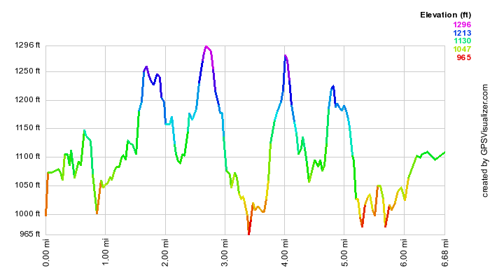 (The image at the left shows the profile of the hike. Remember that all vertical profiles are relative!)
Mount Ivy to Route 106
| Quick Look | |||
|---|---|---|---|
| Difficulty | Round trip | Total climb | Internet Maps |
| 7.5 mi. | 1630 ft. | AllTrails | |
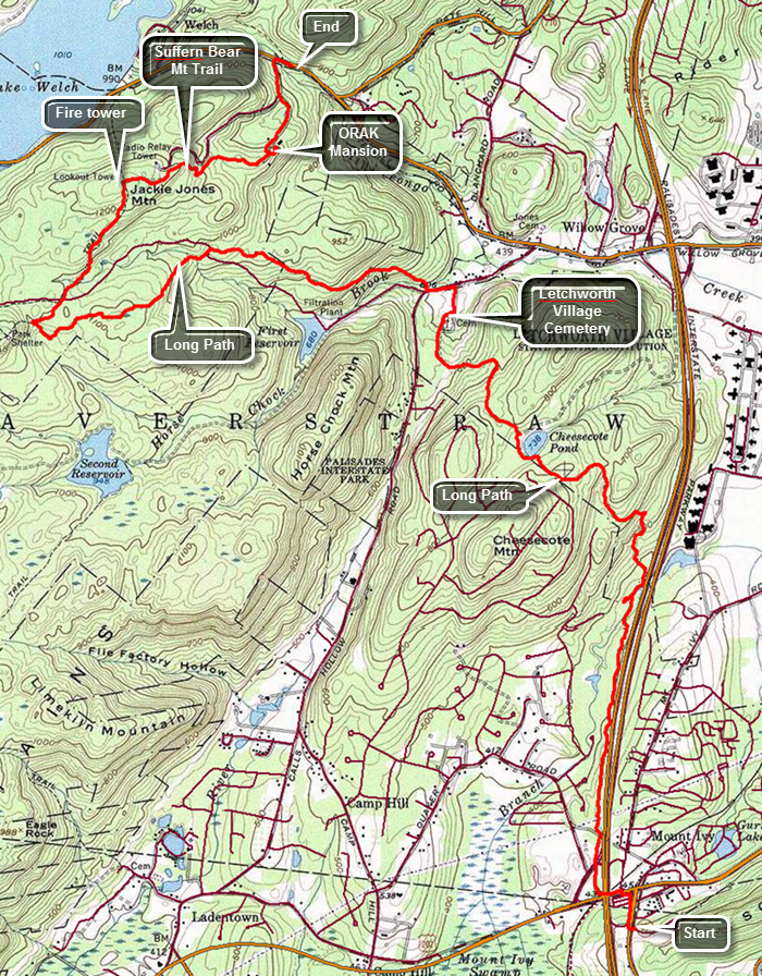
Note: This hike is best done with a car spot as the round trip would be 15 miles over difficult trails.Take the Palisades Parkway to Exit 15 and turn left onto Route 106. Drive to the junction with Route 98 and turn right. The parking area is a short distance up the road on the left. Park one car here. Drive back out to the Palisades Parkway South and take exit 13. Turn left on Route 202 and then right and the next light onto Route 45. The parking area for South Mountain County Park is just up the hill on the left. Walk down Route 45 to the traffic light and cross Route 202 to the other side. Walk under the parkway and then up a bank to the right. Continue through a short stretch of wood and then cross the exit ramp to the parkway and enter the woods on the other side. For the next 1.2 miles the trail follows a narrow strip of woods along the parkway. At 1.65 miles cross a stream by walking along the edge of a "culvert" that conducts the stream under the parkway. At this point the trail begins to turn to the northwest ascending the northern shoulder of Cheesecote Mountain. At about 2.4 miles the trail joins a road which skirts Cheesecote Pond. Turn to the left and follow the blazes around the pond. The trail soon enters the trees again on a woods road. Ascend a small hill and then descend the other side of the hill and head down toward Call Hollow Road. At 3.5 miles there is a cemetery that is marked on the map. There are very few gravestones with most plots being marked only by a small metal marker with a number. As you continue around the cemetery there are some stone benches in front of a monument with a bronze plaque inscribed with a list of names. The plaque has an inscription that read "Those Who Shall Not Be Forgotten". One of the stone benches bears the words "Giving Names to Souls Forgotten No Longer". This is "The Letchworth Village Cemetery 1914-1967". Letchworth Village was a residential institution located in Rockland County built for the physically and mentally disabled of all ages from the newborn to the elderly. It was opened in 1911 and at its peak consisted of over 130 buildings spread out over many acres of land. Many of the residents were placed there by their families and forgotten. Walk out the access road to Call Hollow Road, turn left and walk a few hundred feet up the road before turning right into the woods at 3.7 miles. Cross a stream on a bridge and follow the aqua blazes as best you can. The problem is that the blazes are few and hard to spot among the trees. At 4.6 miles the trail intersects Old Turnpike. Cross the wide woods road to pick up the blazes of the Long Path. Cross a small stream and watch carefully for the blazes on the other side as they are hard to spot. From this point on the trail is poorly marked. The trail continues to ascend and at 5.7 miles comes to an intersection with the yellow blazed Suffern Bear Mountain Trail and a woods road. If you need to "tag" the Big Hill shelter follow the aqua blazes to the left. Walk up to the shelter and then back to this junction. Otherwise make a hard right and follow the yellow blazes. In .7 miles you will be at the top of Jackie Jones Mountain. There is a fire tower here which is not blocked so you may climb to the landing just under the cab. There are a few steps missing and the remaining steps and landing have seen better days. There is a nice view from the top except for the communications complex just to the northeast of the fire tower! To the north of the tower is Lake Welch and farther to the east the Hudson. Get back on the trail and negotiate a few open rock faces until you come to the ruins of the ORAK Mansion at 7.5 miles. This mansion was built in 1923 by George Briggs Buchanan, a vice president of the Corn Products Refining Company, which manufactured Karo syrup. Orak is Karo spelled backwards. After Buchanan died in 1939, his heirs sold the mansion to the park, and it was demolished in 1973. Walk to the right off the trail and into the area that was once the dining room. Little remains except for a rock wall with a door and small round windows. Buchanan had the floor of the dining room built to sway like the deck of a ship and the round widows acted as portholes. Return to the trail and walk down the hill passing the remains of the mansion, the servants quarters and the gatehouse. The trail soon meets the access road for the communications complex and it is less than half a mile to Route 106. Turn right on the road and walk a few hundred feet back to the car.
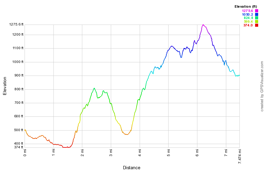 (The image at the left shows the profile of the hike. Remember that all vertical profiles are relative!)
Tors: Little Tor and High Tor
| Quick Look | |||
|---|---|---|---|
| Difficulty | Round trip | Total climb | Internet Maps |
| 8.5 mi. | 1492 ft. | AllTrails | |
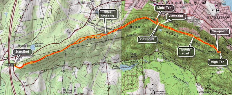
Take the Palisades Parkway to Exit 13 and turn onto Route 202 East. At the first traffic light turn south on Route 45. Just up the hill is a parking lot on the right or east side of the road. Park here. Note the signs warning about ticks and Lyme Disease and be sure to take appropriate precautions. The hike is a relatively straight forward out and back route that follows the Long Path for its entire length. The trail meanders up and down some and back and forth only slightly as it follows the ridge line the entire way. You may cut off the first part of the hike by parking on Route 33 where the Long Path crosses the road. There is room for several cars. Little Tor and High Tor are both east of this parking area and the "trail" is over wide woods roads for the mots part.
From the Route 45 parking area walk east on the Long Path following the aqua blazes. Walk off the trail to the left or right occasionally to enjoy the view. North or left is heavily populated while south or right seems more wild. After 1.75 miles, you will descend to Route 33. Be careful when crossing since both north and south have blind curves and the drivers are always going too fast. At this point the trail becomes a wide road which is often covered with stone chips. The walking is easy and your pace can increase. After only .3 miles a power line crosses the trail and a path leads up and to the left. This is a good lookout to the north but nothing like what is to come. In a little more than 1 mile from Route 33 a wide path turns to the left away from the main trail and leads to Little Tor.
As you walk up the path stop on the edge of the cliff and look at the views laid out below. Now turn back to the path and follow it to the top of Little Tor for the really remarkable 360 degree panorama. The Hudson River is to the east and the jutting rock formation is part of High Tor. When you have taken in all you can, retrace your route to the main trail and walk another 1.25 miles to High Tor. The trail breaks up a little and may be wet in places but this is not really a problem. As you approach High Tor you may wonder how you can climb such a massive piece of rock. Do not fear! The Long Path bends to the right hear and then turns sharply left up the "back" of the tor. This part of the trail is steep in places with some rock scrambling but it is also short and well worth the effort.
After the brief climb, the trail levels some and then ascends to the top of the tor. To the left is a large, flat, open rock outcropping which offers unhindered views of the populated area below. There are also views of the Hudson River and the more forested areas west and south. Immediately to the east rises another prominent rock outcropping which is the top of the tor. Head for this area and ascend over the bare rock face which can be slippery when wet. Near the top you will see four anchors which are all that remain of a tower which housed and airplane beacon. You will now have an unhindered 360 degree view of all that is near and far. On a clear day the view is one of the nicest in the lower Hudson Valley. After getting a drink and a snack, take some pictures and then retrace your route back to the car.
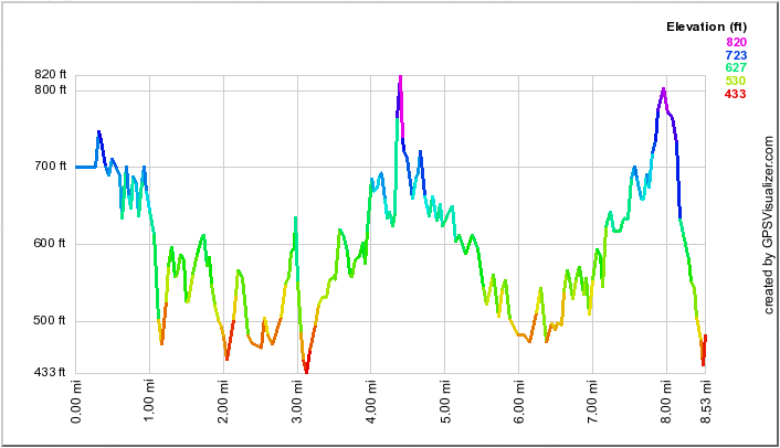 (The image at the left shows the profile of the hike. Remember that all vertical profiles are
relative!)
(The image at the left shows the profile of the hike. Remember that all vertical profiles are
relative!)
Landing Road to High Tor
| Quick Look | |||
|---|---|---|---|
| Difficulty | Round trip | Total climb | Internet Maps |
| 12.0 mi. | 2610 ft. | AllTrails | |
Take exit 12, Palisades Center, off the NYS Thruway. After getting off the exit watch for signs for Route 303 north. Watch for Lake Road on the right at a stop light. Turn right and followed Lake Road to Route 9W. Cross 9W to pick up Rockland Lake Road and drive around the southern tip of the lake and north along the eastern shore. At the intersection with Landing Road turn right onto Landing Road and park in the small lot. Look for the aqua blazes of the Long path on the north side of the parking area. The trail immediately begins a climb from the parking area as it passes by the Wells Family Cemetery. Within about .25 miles there is a high point but the trail immediately starts down the other side. This pattern continues all along the ridge. Along the ridge you may find a few limited viewpoints shown on some maps and mentioned in some trail description. Almost all of these points are now obscured by trees. You may try walking off the trail to find lookouts but it may be best to wait for High Tor! At 2.7 miles the trail hits the highest point on the ridge and starts down toward Lost Clove and Route 9W. On the way down there is a white blazed trail called the Treason Trail on the right. Descend to Route 9W where there is a small parking area. Straight across Route 9W is Lost Clove Road which is closed to traffic for some distance. Cross Route 9W and hike on Lost Clove Road passing the Tilcon Quarry on the right. The basalt that makes up most of the Palisades has been quarried here since 1920 and the operation is huge. Soon Last Clove Road becomes open to traffic and the Long Path then turns right on Scratchup Road to get to Old Route 303 or the Haverstraw Road. Turn left on Old Route 303 and start hiking west being very careful as the road has almost no shoulder and there can be a lot of traffic. Hike for about a quarter mile until the blazes indicate a right turn into the woods to begin the assault on High Tor. The trail is very rocky and poorly blazed in a few spots. After an initial climb the trail levels a little and then starts a gentle ascent passing a house on the left as it makes its way up toward the ridge. Hike almost directly north and at 5 miles descend a little to the junction with the spur trail to the left to High Tor Vineyards. Continued a little farther north and then follow the trail as it turns northwest to start the ascent up what is sometimes called South Mountain. You can chose to ascend through a rock scramble to the very top or follow the blazes of the Long Path around to the south side for an easier route. Follow the blazes to the final climb to the top of High Tor. The trail climbs the south side of the tor to the top with good views in all directions. From the summit the Hudson is just below with the village of Haverstarw at the base of the tor. To the south is Deforest Lake in the foreground with several other lakes further away including Rockland Lake. When you are ready, head back the way you came. Follow the trail back to Old Route 303 and from there walk back to Route 9W. You may now hike back over the Hook Mountain ridge or walk down to the bike path along the Hudson. Walk through the gate and follow the path to the left down to the railroad tracks. Carefully cross the tracks and watch for a path leading down to the bike path that runs along the river from Haverstraw to Nyack. Once on the bike path turn right to walk south to your car. Within a short distance there is a sign marking the spot where Benedict Arnold and John Andre discussed the betrayal of the fort at West Point. A little farther along there is a tunnel to the right that allows the trains to pass under the Hook Mountain ridge. At 8.3 miles there are some ruins down near the water. Walk down a path to the shores of the Hudson. The ruins aren't very old and aren't very interesting. All along the entire bike path are small stone buildings which look like they may have been bathhouses or restrooms. You may walk to the waters edge where you will be almost at sea level. When you are done, walking back up to the bike path and turn left to head south again. The path actually rolls some unlike the southern portion which is very flat. Eventually you will walk up a little hill a junction. Turning to the left takes you to Nyack. Turn right and follow the paved road up the hill and back to the parking area.
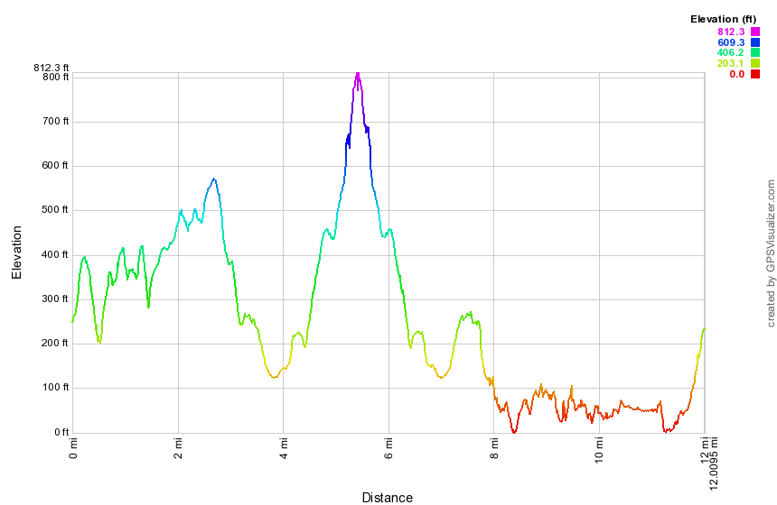 (The image at the left shows the profile of the hike. Remember that all vertical profiles are relative!)
Nyack to Landing Road
| Quick Look | |||
|---|---|---|---|
| Difficulty | Round trip | Total climb | Internet Maps |
| 10.8 mi. | 2070 ft. | AllTrails | |
Take exit 11, Nyack, off the NYS Thruway. Turn left at the traffic light at the end of the exit onto Route 59. Park in a parking lot in one of the strip malls as close to where you turned as possible. Be sure to park away from any stores. Walk west on Route 59 to Mountainview Avenue and turn right to head north. The bridge over I87 has a very narrow sidewalk but after that there sidewalks until the trail cuts right into the wood at .3 miles. Walk through a strip of forested land that is bordered on either side by houses and apartment buildings. The Long Path begins to head east and at about .6 miles skirts Oak Hill Cemetery. The Hudson River and Tappan Zee Bridge are visible through the trees. The views are good but much better views are to come! Follow the trail as it turns left and starts up a hill to a water tank. The trail begins to head north and then northwest rolling a little. At about 1.4 miles look to your right to see Nyack High School. At this point the trail starts a somewhat steep descent to Christian Herald road at 1.7 miles. Passed through a gate, turn right and walk on the sidewalk along the road. Continue on the sidewalk passing the high school and the Ramah Jewish Day Camp on the way to the intersection with Route 9W. At 9W turn left to hike north .4 miles. There are no sidewalk but the shoulder is wide. At 2.5 miles cross the road and pass through an opening in the guardrail. A short distance into the woods a white trail comes in from the right. This is the Upper Nyack Trail which you will use to hike a loop on the way back. The Long Path continues on a wide woods road which parallels Route 9W. The road is well constructed with stone laid up to support the road surface. The trail begins to gain elevation as it heads northeast and away from 9W. At 2.8 miles you enter Rockland Lake State Park. There are a few lookouts but continue to the top of Hook Mountain. At 3.25 miles you will reach the summit and the highest point on the hike. The views were spectacular in all directions. Of course the dominant view is the Hudson River to the east as well as the village of Nyack. You can see the Tappan Zee Bridge and the construction being done to create the new span. The Hudson is at its widest here and these views make that very clear. To the north is Rockland Lake. Walk down off the summit of Hook Mountain and then start up the next rise. Near the top are some more nice views. CAREFULLY walk to the edge of the cliff for a really breathtaking experience. At 4 miles begin your final ascent and at 4.7 miles gain another high point with some views. The views were much the same as from the other lookouts. Descend from the final high point to the west side of the ridge and again walk on a wide woods road. To the left is Rockland Lake. The trail descends steeply at times with a few switchbacks as it heads toward Landing Road. The final part of this descent is over a very rocky area and brings you to two old foundations. Walk out to the parking area and read the sign that gives the history of the Knickerbocker Ice Company. The company used the pure waters of Rockland Lake for ice and was one of the largest companies in the area. Turn right on Landing Road walk down the park road to the Shore Trail which is a bike path along the Hudson. The bike path begins as a paved road which leads down to the waters edge to a picnic area. After this the path is stone dust which is much softer on the feet. At 7.4 miles you will be at the Nyack Beach State Park parking area. Continue by walking up the hill from the parking area turning left on North Broadway to begin the Upper Nyack Trail. Almost immediately turn right on Larchdale Avenue and walked passed the Marydell Faith and Life Center. Marydell was founded by the Sisters of Our Lady of Christian Doctrine to provide a place for disadvantaged youth during the summer. At the end of Larchdale turn left on North Midland Avenue and after a few hundred feet follow the white blazes into the woods at 8 miles. The Upper Nyack Trail heads east for .4 miles and gains enough elevation to meet the Long Path near Route 9W. Turn left on 9W and head back to the intersection with Christian Herald Road. Turn right at the intersection and walked back passed Nyack High School. The trail turns left into the woods just after the high school and you may retrace your route to the car. If you want to stay on the roads, continue on Christian Herald Road to Mountainview Avenue. Make the left turn and start up the road. For the most part you will have a good view of oncoming traffic and after a short climb there will be sidewalks. Continue on Mountainview Avenue to Route 59. Turn left and walk back to your car.
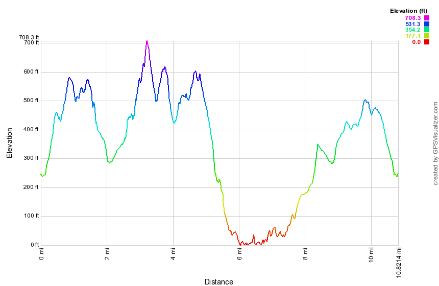 (The image at the left shows the profile of the hike. Remember that all vertical profiles are relative!)
New Jersey Border to Nyack
| Quick Look | |||
|---|---|---|---|
| Difficulty | Round trip | Total climb | Internet Maps |
| 10.5 mi. | 1720 ft. | AllTrails | |
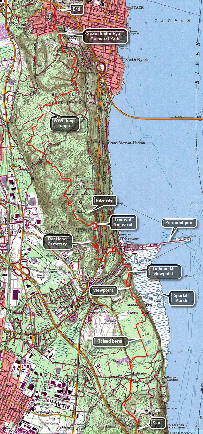
This hike is 10.5 miles ONE WAY. Unless you feel you can cover 21 miles, you will need to arrange a car spot or a ride.Take exit 11, Nyack, off the NYS Thruway. Turn left at the traffic light at the end of the exit onto Route 59. Park in a parking lot in one of the strip malls as close to where you turned as possible. Be sure to park away from any stores. Drive another car or get a ride to the Lamont-Doherty Observatory entrance which is south on Route 9W at the New York-New Jersey border to begin your hike. Walk passed then gatehouse down the sidewalk to find the aqua blazes of the Long Path. The first .7 miles of the trail heads downhill and parallels Route 9W passing through some hardwood forest and eventually meeting Route 9W. The traffic on 9W can be heavy at times but the road has wide shoulders. Head north on the road until 1.2 miles where the trail crosses the road to the parking area for Tallman State Park on the other side. The trail begins as a wide woods road and bike path with a firm surface which makes it easy to walk. Walk east and then turn north at 1.5 miles on what is more like a hiking trail. For the next .5 miles the trail follows along a raised walkway with lower wetlands on both sides. Some areas are just marshy while others have small ponds. At 2 miles turn east again and then start heading NNW along the edge of the escarpment. Look to the right to see the Hudson River and some views of the large Sparkill marsh below. Trees limit the photographic opportunities until the trail descends a hill to an area with benches at about 2.9 miles. From this area walk up a paved walkway and then turn onto a trail to get to the plateau that makes up what is called Tallman Mountain. Walk passed the shelter at the top on a paved roadway to a lookout just north of the shelter. Tallman Mountain has a maximum elevation of only 171 feet. From here you can still see the marsh below as well as views of the Tappan Zee Bridge and the village of Piermont below. The most interesting feature is a long spit of land that juts out into the river from Piermont. This is the mile long Piermont pier that was a terminus for the Erie Railroad. It also served as a point for ferry service to Dobbs Ferry on the other side of the river. Walk a little farther to find another lookout that has views down into Piermont. Back on the main trail walk down a steep hill to the road. Cross Sparkill Creek on a bridge and start walking north on Piermont Avenue passing some small shops. The trail is well-marked by aqua blazes and soon they will indicate a left turn onto a side street. Walk up Tate Street and near the top turn left up a set of stairs to Ash Street. At the corner across from you is the old Erie Railroad station for Piermont. The building is over 100 years old but has been resided. Follow the blazes on Ash Street west to Piermont Place. Head south on Piermont Place and then west on Crescent Road. Crescent Road is a dead end but the trail follows an old fire road at the end which heads south and then west to Route 9W. Turn right on Route 9W and then almost immediately left on Castle Road. Follow Castle Road for a short distance until the blazes indicated a right turn into the woods. Continue on the trail passing through some woods but still climbing. The trail eventually leads to the roads that run through the Rockland County Cemetery. Turned right almost 180 degrees and ascend to the top of the hill through a switchback. Follow the roads heading north along the escarpment and pass by many impressive grave markers. At 5 miles the Long Path passes the memorial for John C. Fremont. Fremont was a colorful figure who had a checkered career as an adventurer, politician, and military officer. Continue to follow the road until the blazes indicate a turn to the right. The trail heads west and then north continuing to climb and leaving the Rockland County Cemetery land to cross property marked as "Military Reservation". The Long Path skirts the summit of Mount Nebo and then reaches a high point at 585 feet on the shoulder of another unnamed hill. At about 5.75 mile an orange trail branches off to the right. The trail goes to Mount Nebo which was once the site of a Nike missile silo that protected New York City. It is now a recreation area. The trail starts to descend through hardwood forests as it enters Clausland Mountain County Park. At 7 miles cross Clausland Mountain Road and enter Tackamack Town Park which is maintained by the Town of Orangetown. Head northwest for about .25 miles to a small pond where the trail turns northeast and at 7.5 miles crosses Marisco Court to enter Blauvelt State Park. This is the first time on the hike that there is an evergreen forest as the trail begins to swing to the northeast. At about 8 miles you will cross over a low cement wall and turn to the right. Soon you will come to a higher cement wall. These are the remains of a World War I firing range and target walls. The tunnels connecting the two still remain here underground. Begin another ascent crossing a few streams along the way some with and some without bridges. At 8.8 miles cross North Tweed Boulevard and continue to climb to the highest point on the hike at about 625 feet. Some maps indicate a viewpoint here but there isn't too much to see. There is a large amount of broken glass on the rocks where inconsiderate people had found breaking bottles irresistible! Descend from this high point only to climb another and then another as you head generally north toward Nyack. Leave Blauvelt State Park and cross Bradley Hill Road at 9.8 miles. Make a quick ascent and then start the final descent into town. You are now in Sean Hunter Ryan Memorial Park. Sean Hunter Ryan was a Rockland County resident who died with his climbing partner, Philip Otis, on Mount Rainier in 1995. The two young men were park rangers involved in a rescue mission under extremely dangerous conditions. They remain the only two rangers to die on a rescue mission on Rainier. The trail comes to Towt Street where you should walk downhill to Waldron Avenue. Walk down the street and out to Route 59. Cross Route 59 and walk back to your car.
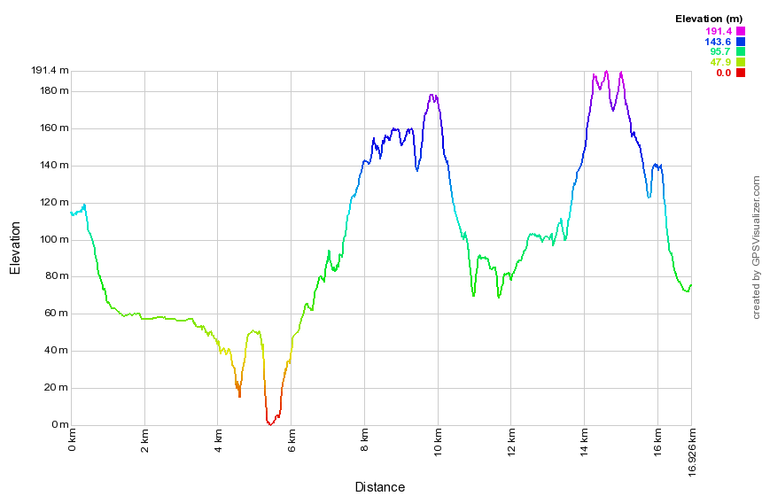 (The image at the left shows the profile of the hike. Remember that all vertical profiles are relative!)
Fort Lee to New York Border
| Quick Look | |||
|---|---|---|---|
| Difficulty | Round trip | Total climb | Internet Maps |
| 13.5 mi. | 1265 ft. | AllTrails | |
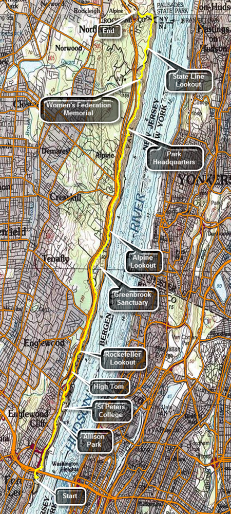
This hike is 13.5 miles ONE WAY. Unless you feel you can cover 27 miles, you will need to arrange a car spot or a ride.Take exit 11, Nyack, off the NYS Thruway. After getting off the exit turn left on Route 59 and then right on Route 9W not far down the road. Head south on Route 9W passing through Palisades and turning left onto Ludlow Lane at the state border. Park on the shoulder of Route 9W just north of the bus stop as far off into the grass as possible. Call a car service for a ride to Fort Lee or drive another car to Fort Lee Historical Park to start the hike. The easiest route is to get on the Palisades Parkway just south of where you are parked. Get off at exit one and take Route 505 south. The entrance to Fort Lee Historical Park is on the left after you pass under I95. The first part of the trail goes out to Route 505 where it heads north and passes under I95. Right after this it goes up a set of stairs on the right and then crosses another road on a pedestrian bridge. From here the Long Path passes through a wooded strip of land that is for the most part sandwiched between the Palisades Parkway on the west and the escarpment and Hudson River on the east. At about .5 miles there is a side trail that goes out to a viewpoint which is the first of many you will encounter. The George Washington Bridge and the city skyline are prominent from this lookout. Walk a little farther and there is another lookout. At the base of the cliff there is what looks like a park and the views of the Palisades cliffs are impressive. This general pattern repeats itself many times throughout the hike. At .8 miles blue and white trail blazes mark the Carpenter's Trail to the right that leads to the Shore Trail. At about 1.6 miles there is an iron fence ahead of us and the Long Path blazes turn to the left around Allison Park. Walk passed the entrance to the park, along the access road and then on a narrow strip of land near the parkway. Walk in front of St. Peter's College at about 2.1 miles. After passing the college, there is another viewpoint. At 2.5 miles descend some steps to East Palisades Avenue, turned right and then almost immediately left to cross the road. The aqua blazes go up some steps and then onto the trail along the edge of the cliffs. There are again nice views to the east side of the Hudson. At about 3.1 miles the Long Path turns left but there is a nice viewpoint straight ahead. Walked on an unmarked trail to the top of High Tom for some great views. Continue on the Long Path to some more great views at about 3.5 miles at the Rockefeller Lookout. At 4.6 mils there is another lookout at Clinton Point opposite East Clinton Avenue. After another viewpoint, there is a chain link fence a fence at 5.1 miles. Walk along the fence until you cross a stream and a road at 5.4 miles. There is a gate in the fence which surrounds Greenbrook Sanctuary which is a private sanctuary that preserves areas of forest and habitats that were once common in the area. Continue on the Long Path dipping twice to cross streams. At 6.25 miles a red trail, the Huyler's Landing Trail leaves the Long Path to the right and heads down to the Shore Path. Continue straight ahead on the Long Path which again runs along the cliffs. At about 6.75 miles reach the Alpine Lookout which has several different viewpoints. The largest one is near the top of a short hill with views up and down the river. Continue along a stone wall and then enter the woods again. The trail is on an old paved surface again and passes by several stone walls and some foundations. Continue walking along the trail with the parkway on the left and glimpses of the cliffs and river on the right. At 8.35 miles descend a hill to the Alpine Access Road bordered by a stone wall. The trail turns right and passed through a tunnel under the road. On the other side the trail begins to ascend a very rocky trail as it heads toward the headquarters for the New Jersey section of the Palisades Interstate Park. The trail continues at the far end of the parking area and passes through hardwood and evergreen forests. At 9.3 miles there is a path to the right which has a short bridge out to a rock outcrop. Walk across the bridge and out onto the rocks for some more nice views of the river. Over the next mile or so the trail follows some dirt and gravel roads while other paths cross the trail. Watch the aqua blazes carefully and you will have no trouble staying on the Long Path. At 10.7 miles there is a clearing with a small "castle". This is a monument to the New Jersey Federation of Women's Clubs which played a big part in preserving lands on the Palisades. The monument also has another good lookout. Climb the stairs to the top of the monument if you like although there are no better views from the top. Continue on the Long Path by descending some stone steps. Pass a blue and white trail, the Forest View Trail which descends to the Shore Trail. At 11.2 miles cross the access road to the State Line Lookout. There are many ski trails in the area but the aqua blazes are always very prominent. Continue to follow the blazes until at 11.7 miles and you will be behind the State Line Lookout snack bar. The trail turns left here but walk out to this very large viewpoint. Walk back to the trail and follow it as it winds its way back to the old access road. Walk along the road until the trail turns to the right into the woods again. At 12.4 miles there is a chain link fence that marks the state border. The Long Path turns right here and begins to descend a set of stone steps which are steep at times. Turn left and pass through a gate into New York continuing to descend on the steps. At 12.8 miles the descent ends and you cross a small stream on a bridge. A white trail to the right leads down to the Peanut Leap Cascade and the remnants of Lawrence Gardens. Continue on the trail which can be wet at times in these lower spots. The trail heads up a hill and soon meets Ludlow Lane. Walk back to your car on Route 9W.
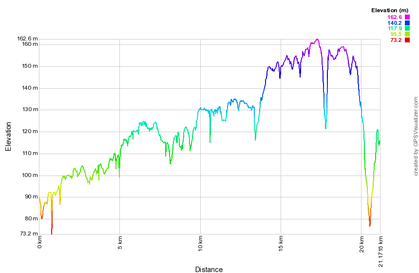 (The image at the left shows the profile of the hike. Remember that all vertical profiles are relative!)