
South Twin
| Quick Look - South Twin (from east Twin) | |||||
|---|---|---|---|---|---|
| Difficulty | Round trip | Total climb | Location | Internet Maps | |
| 7.4 mi. | 1950 ft. | N42.2291 W74.4388 | AllTrails | ||
Turn onto Bloomer Rd. off Route 23A just west of Tannersville. At the Y in the road bear left onto
Platte Clove Rd. Continue on this road for about 3.75 miles and turn right on Prediger Rd. Go to the end
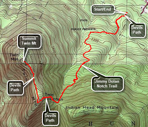
of the road and turn right onto the access road to the parking area. The red Devil's Path begins at the Prediger Rd PA. Get on the red-blazed Devil's Path
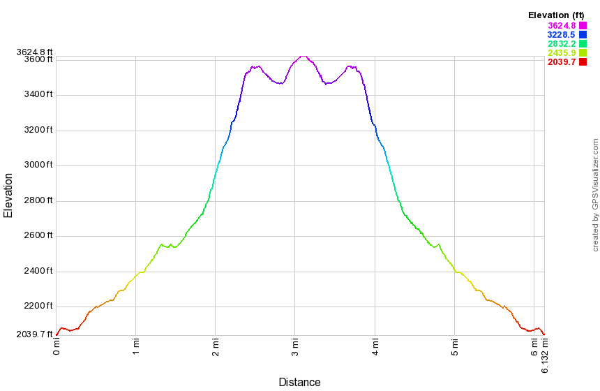
and hike .25 miles to the junction with the Jimmy Dolan Notch Trail. Bear right on the blue Jimmy Dolan Notch Trail and hike 1.35 miles to Jimmy Dolan Notch which is the col between Indian Head and Twin Mountains. The trail starts out gaining elevation gradually and then becomes steeper and rockier as you approach the notch. The last .3 miles ascends at a 27% grade. Turn right on the red Devil's Path and begin the ascent of Twin Mountain hiking another .3 miles at a 27% grade until the trail levels. Be sure to watch for a lookout on the left side of the trail which has great views of the Hudson River, Indian Head Mountain and the Catskill Community. The Devil's Path breaks out onto the southern peak of Twin where there are more great views. From here the descent to the southwest is steep but eventually flattens some between the two peaks. Climb to the highest point on South Twin and the return the way you came.
A second option is to bushwhack from the south end of the Mink Hollow Trail. Take Route 28 to Route 212 in Mount Tremper and follow it all the way to Lake Hill near Cooper Lake. In Lake hill I turn north on Mink Hollow Road and drive to the parking area at the end. The road is paved to the parking area. From the parking area head north on the trail until the private property on the left of the trails ends. From this point head east and slightly south toward the high point of South Twin. This route requires crossing at least one stream. There are also some very steep climbs on the direct route to the east. Heading north a little and climbing to the ridge may be easier.