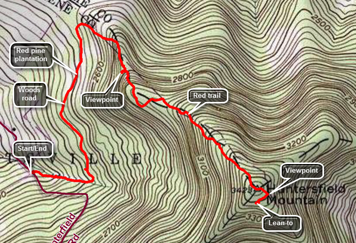
Huntersfield Mountain
Huntersfield is on the Catskill Highest Hundred list. It is often done in conjunction with Richmond Mountain which is also on the CHH list. Ashland Pinnacle, Ritchmeyer Mountain and Mount Pisgah also lie along this ridge. Huntersfield has excellent views to the north, south and east. The southern view from the lean-to at the summit reveals the mountains on the Devil's Path but is dominated by Slide Mountain.
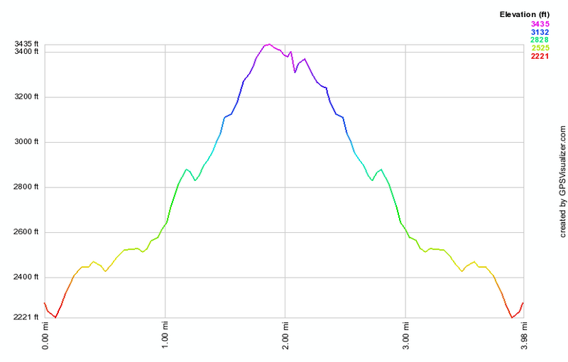
| Quick Look - Huntersfield (out and back from the west) | |||||
|---|---|---|---|---|---|
| Difficulty | Round trip | Total climb | Location | Internet Maps | |
| 4.3 mi. | 1276 ft. | N42.35556 W74.3467 | AllTrails | ||
 Of course, directions to a location depend on your starting point. Find Prattsville on Route 23 just SE of the Schoharie Reservoir. The town isn't very big. Turn north onto Washington Street which soon becomes Route 10. Watch for a sign with a Y indicating a definite split in the road. Do NOT worry about any of the side roads. At the Y bear left onto Route 11 which soon turns into Marv Rion Road. At the end take a right onto Huntersfield Road which takes you straight toward the mountain and an apparent DEAD END! Continue ahead on the dirt road in good condition. After a short trip up the dirt road a sign announcing Huntersfield Forest will appear on the right. Park on the left across from the sign to avoid blocking the road.
The first part of the trail parallels and then crosses a small stream before joining a wide and well-maintained woods road. The trail follows this road through a beautiful pine forest as it slowly climbs making its way north and AWAY from the mountain. Several places along the road significant blowdown blocks the main trail but the path has been rerouted in these areas. The trail then makes an abrupt turn to the east and then to the southeast as it begins to climb up toward the summit. After a short distance there is a viewpoint to the right of the trail which is worth investigating. There are MANY other views along the way but none allow photography since they are blocked by trees even in the winter. The trail continues up and at times passes through some rocky areas but none are difficult. More possible viewpoints disappoint. In about a mile a yellow blazed trail comes in from the right and just after it a USGS benchmark signals the summit. Continue passed this area to where the red trail continues straight ahead to the Ashland Pinnacle and Richmond Mountain beyond. Turn right here on the yellow trail and head toward the lean-to. Immediately after the turn a lookout appears on the left. The views here are toward the east with the Pinnacle and Richmond visible. After taking in these views, continue on the yellow trail at the lean-to. Here the trees have been cut to afford a view to the south. Slide Mountain dominates this views but other peaks are visible. When you have had your fill, retrace your steps back to the car.
| Quick Look - Huntersfield (loop from the west) | |||||
|---|---|---|---|---|---|
| Difficulty | Round trip | Total climb | Location | Internet Maps | |
| 4.4 mi. | 1240 ft. | N42.35556 W74.3467 | AllTrails | ||
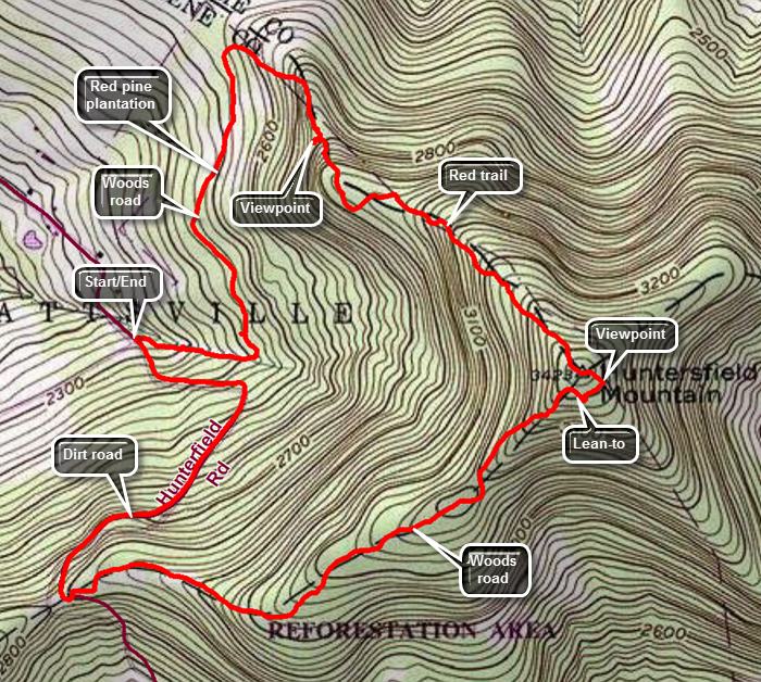 Of course, directions to a location depend on your starting point. Find Prattsville on Route 23 just SE of the Schoharie Reservoir. The town isn't very big. Turn north onto Washington Street which soon becomes Route 10. Watch for a sign with a Y indicating a definite split in the road. Do NOT worry about any of the side roads. At the Y bear left onto Route 11 which soon turns into Marv Rion Road. At the end take a right onto Huntersfield Road which takes you straight toward the mountain and an apparent DEAD END! Continue ahead on the dirt road in good condition. After a short trip up the dirt road a sign announcing Huntersfield Forest will appear on the right. Park on the left across from the sign to avoid blocking the road.
The first part of the trail parallels and then crosses a small stream before joining a wide and well-maintained woods road. The trail follows this road through a beautiful pine forest as it slowly climbs making its way north and AWAY from the mountain. Several places along the road significant blowdown blocks the main trail but the path has been rerouted in these areas. The trail then makes an abrupt turn to the east and then to the southeast as it begins to climb up toward the summit. After a short distance there is a viewpoint to the right of the trail which is worth investigating. There are MANY other views along the way but none allow photography since they are blocked by trees even in the winter. The trail continues up and at times passes through some rocky areas but none are difficult. More possible viewpoints disappoint. In about a mile a yellow blazed trail comes in from the right and just after it a USGS benchmark signals the summit. Continue passed this area to where the red trail continues straight ahead to the Ashland Pinnacle and Richmond Mountain beyond. Turn right here on the yellow trail and head toward the lean-to. Immediately after the turn a lookout appears on the left. The views here are toward the east with the Pinnacle and Richmond visible. After taking in these views, continue on the yellow trail at the lean-to. Here the trees have been cut to afford a view to the south. Slide Mountain dominates this views but other peaks are visible. When you have had your fill, continue passed the lean-to on the yellow trail following a woods road. Soon the yellow trail will turn to the right and ascend back to the summit. Continue on the wide woods road which is not marked but is very obvious. At 3.6 miles there is a large pile of red shale. Walk out to a dirt road which is the junction of Jim Cleveland Road coming up from the south and Huntersfield Road. Turn right to walk the woods road back to the car. The road is usually in good shape. Continue to follow the woods road until you spot your car on the right side of the road.
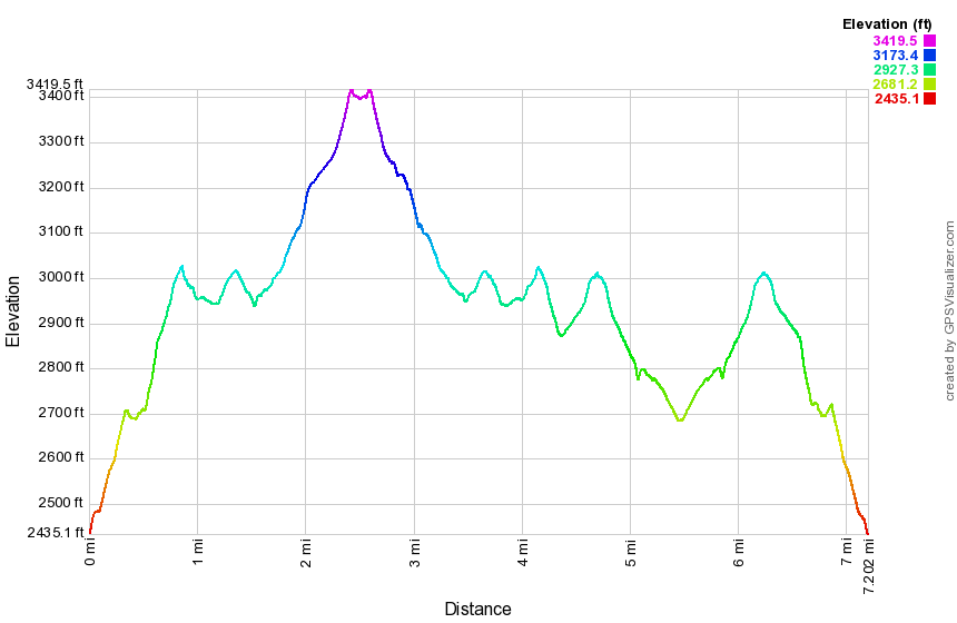
| Quick Look - Huntersfield and Ashland Pinnacle (from Partridge Road) | |||||
|---|---|---|---|---|---|
| Difficulty | Round trip | Total climb | Location | Internet Maps | |
| 7.2 mi. | 1876 ft. | N42.35476 W74.32104 | AllTrails | ||
Of course, directions to a location depend on your starting point. Find Prattsville on Route 23 just SE of the Schoharie Reservoir. The town isn't very big. Turn north onto Washington Street which soon becomes Route 10. Continued east for about 6.5 miles to Partridge Road. Turn left and head north on the paved road. The road turns to rough pavement and then gravel. After 1.6 miles, the road comes to a dead end in a rather large parking area.
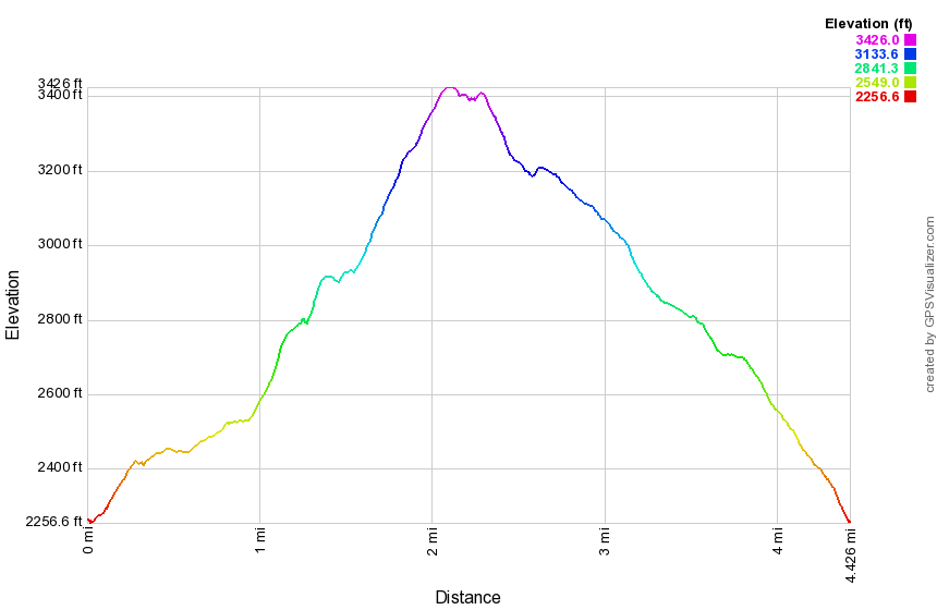
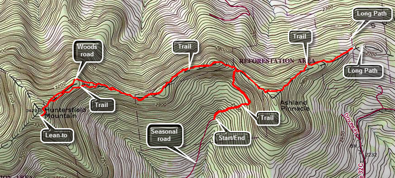
The yellow trail for the parking area is obvious. The yellow blazes seem to follow a woods road up to a ridge but the markers are few and far between. You may have to simply follow the woods road and ATV tracks which keep leading up. The trail starts off heading northeast but at .3 miles the trail levels off and begins heading northwest and then north to the ridge at .65 miles. The yellow trail ends here. Turn left to follow the red blazes west toward Huntersfield Mountain. The trail continues to climb until about .9 miles when it hits the top of a small hill and then starts to descend. In some places the aqua blazes of the Long path are still intact even though that trail has been relocated to the east! The trail rolls as it drops a little and then comes to the top of another small hill at 1.3 miles. It follows the ridge line and is sited mostly along wide woods roads which makes the walking pretty easy. At 1.75 miles the woods road continues straight ahead with no obstacles but the trail veers right into the woods and then rejoins the woods road about 100 feet ahead. Continue to follow the woods road watching for blazes the best you can. They sometimes disappear and then reappear later so use your best judgment. Following the woods road as long as it is going west and up works well. At 2.45 miles there is a junction with the yellow spur trail to the lean-to. Turn left and head over to the lean-to. There is a viewpoint cut out in front of the lean-to looking south to the Catskills. Head back along the yellow trail to a viewpoint that looks east toward Ashland Pinnacle. Return to the red trail heading east to go back the way you came. At about 2.7 miles turn right off the nice wide and flat woods road and begin to follow the red markers of the trail. It may be hard to spot the markers and the trail becomes narrower. At 3.1 miles rejoin the woods road. At 4.4 miles you will be back at the junction with the trail back to the car. Continue straight ahead on the red trail. Over the next quarter mile ascend to the shoulder of Ashland Pinnacle along a woods road. Immediately after this point the trail begins to descend as the trail drops off the ridge a little and then regains it. Walked another .8 miles losing about 340 feet of elevation. At 5.5 miles the trail breaks out into a clearing where there are aqua blazes for the Long Path. Turn around and head back the way you came. At 6.6 miles you will be back a the junction with the yellow trail to your car. Turn left and followed your route back to the car.