Stoppel Point
Stoppel Point (from North South Lake)
| Quick Look | ||||
|---|---|---|---|---|
| Difficulty | Round trip | Total climb | Internet Maps | |
| 7.5 mi. | 1530 ft. | AllTrails | ||
 The hiking trails around the North Lake South Lake Campgrounds may be the most scenic in the Catskills.
As you hike the Escarpment Trail the history and the views just seem to get better with every passing
mile. Many spots have names like Inspiration Point and Artist's Rock. Even places that aren't
named have beautiful views of the Hudson River and surrounding countryside. There are many combinations of paths that
can ;lead to Stopple Point. This path is the shortest and most direct.
The hiking trails around the North Lake South Lake Campgrounds may be the most scenic in the Catskills.
As you hike the Escarpment Trail the history and the views just seem to get better with every passing
mile. Many spots have names like Inspiration Point and Artist's Rock. Even places that aren't
named have beautiful views of the Hudson River and surrounding countryside. There are many combinations of paths that
can ;lead to Stopple Point. This path is the shortest and most direct.
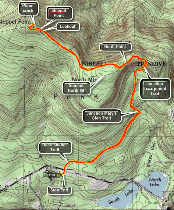
Turn north on Rt 18 from Rt 23A in the town of Haines Falls. After about 1 mile, turn right on Scutt Road just before the entrance to the state campgrounds. Turn right into the parking area. Walk up Scutt Road and across CR-18 to the yellow marked Rock Shelter Trail. Follow this trail for 1.3 miles where it intersects the Mary's Glen Trail. Turn left and follow the Mary's Glen Trail .8 miles to the blue blazed Escarpment Trail. Turn left on the Escarpment Trail toward North Point. Be prepared to CLIMB as you ascend .2 miles to North Point. Take in the views of the lakes and campgrounds below. Stay on the Escarpment Trail as it rises for another .35 miles to an area near the summit of North Mountain. Continue on the Escarpment Trail for another 1.4 miles to an open rock ledge which is Stoppel Point. Enjoy the views to the north and east before turning around and retracing your steps. If you want, continue on the Escarpment Trail for another .5 miles to the wreckage of an old airplane before turning around.
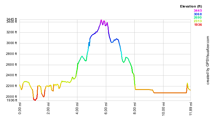
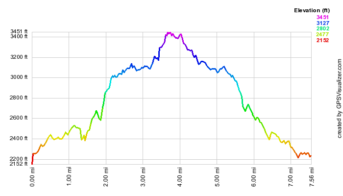 (The image at the left shows the profile of the hike. Remember that all vertical profiles are
relative!)
(The image at the left shows the profile of the hike. Remember that all vertical profiles are
relative!)
Stoppel Point (from Colgate Lake)
| Quick Look | |||||
|---|---|---|---|---|---|
| Difficulty | Round trip | Total climb | Internet Maps | ||
| 11.9 mi. | 1986 ft. | AllTrails | |||
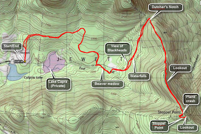
Take Route 23C north from Route 23A in Tannersville. Stay on this road until it crests the hill at Onteora Park and passes the stone church at the top. Stop here for some very nice views of the Devil's Path. Continue down the other side of the hill to East Jewett. Turn onto CR 78 which should have a sign for Colgate Lake. Pass Colgate Lake on the right and park at the DEC parking area on the left. The gate marks the beginning of the yellow-blazed Colgate Lake Trail. The trail starts through a meadow with some nice views of the surrounding mountains. After about a quarter of a mile it enters the woods. The trail is mostly flat and winds its way in back of Lake Capra which is a privately owned inholding in the Catskill Park. There are several bridges of different types over various bodies of running water.
Along the trail watch for a beaver meadow on the left at about 2.5 miles. Walk out to the beaver meadow which was once a beaver pond. There is a nice view of Blackhead Mountain from here and the meadow itself is pretty. Just passed the meadow is a beaver pond and the trail skirts this area. A little further at about 3.1 miles is another meadow with another great view of Blackhead Mountain. A few hundred feet up the trail you can cut into the woods on several informal trails or you can make your own. There is a nice small, secluded waterfall here. Back on the main trail it is another 2.3 miles to the junction of the trail with the Escarpment Trail. This last part of the walk is more uphill as you ascend to Dutcher's Notch. You will be walking between the Escarpment on your right and another ridge on your left. On your immediate left is a deep ravine. The terrain is rugged and beautiful but offers no views.
At the junction with the blue-blazed Escarpment Trail, turn right and be prepared to climb. The trail takes you up to the Escarpment which was on your right as you were coming up the Colgate Lake trail. The trail climbs some but is not too steep. Once on the Escarpment the trail is mostly flat until Stoppel Point. All along the trail you can see that you are on a ridge and that there might be interesting views especially on your left. Keep walking and wait for some real viewpoints! At 1.2 miles is a great lookout right on the trail with views to the north and northeast. Back on the trail the climbing gets steeper now as you begin to ascend to Stoppel Point. In a little less than a mile you will find the wreckage of a two-seater Piper Cub right on the trail on the left. Passed the wreck only a few hundred feet is a lookout to the south and west.
Keep walking on the trail and pass the point where your GPS might indicate the location of Stoppel Point. Walk until you find a DEC signpost and a GREAT lookout to the north and northeast. To get back just retrace your steps. Another option is to park a car at the Schutt Road parking area near North South Lake State Campgrounds. You can then walk through over North Mountain and North Point and experience the rest of the lower end of the Escarpment Trail.