
Bramley Mtn
| Quick Look - Bramley Mtn | |||||
|---|---|---|---|---|---|
| Difficulty | Round trip | Total climb | Location | Internet Maps | |
| 3.7 mi. | 950 ft. | N42.2972 W74.8182 | AllTrails | ||
 From Delhi, NY head north and east on Route 10. In East Delhi cross the river at the Fitches Covered Bridge and turn left on County Route 18. After about 2 miles turn right on Glen Burnie Road and start to look for DEP signs. After a little over .5 miles there will be a woods road on the left with a gate and some room to pull over on the side of the road. There is a trail kiosk near the gate. Park here to begin your hike with a choice of trails.
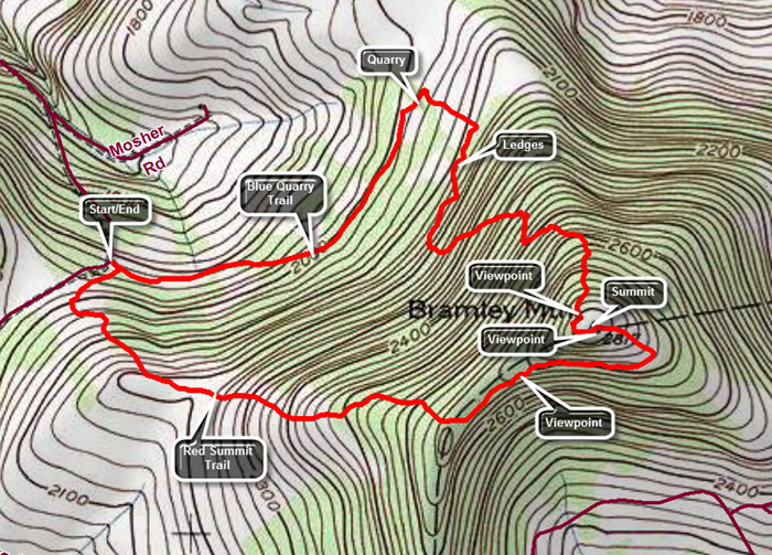
The red Summit Trail goes to the right directly to the summit over 1.8 miles.The blue Quarry Trail goes straight ahead and passes through a quarry before wending its way to the summit over 2.1 miles. Walk straight ahead on the blue Quarry Trail which follows a woods road that is very open but can be damp and muddy in some places. At about .8 miles the trail passes through the quarry and splits with blue markers going both left and right. Head to the right as the trail enters the woods and immediately turns almost 180 degrees. The trail alternates between paralleling the ridge and then heading up the mountain several times before making the final ascent. Eventually the trail turns and begins a steady climb up to the summit. It passes by several interesting ledges and rock formations. There are numerous switchbacks which make the walk longer but mitigate some of the steeper climbs. Near the top the trail passes around and through some rock ledges and the trail crew has expertly created some steps out of natural materials. Near the top at about 1.9 miles and just before the summit is a nice viewpoint with a stone bench. Turn left here and follow the trail too the summit which is only a few hundred feet away. Over the 1.1 miles from the quarry the trail gains 770 feet with and overall average grade of 13% despite the many switchbacks. At the summit you will notice the concrete pilings for the fire tower. There is also a lookout to the south and southeast and the Pisgahs near Andes are clearly visible. They were once the site of a ski area. Return to the summit and walk in the direction that the arrow points to follow markers for the red Summit Trail that will return you to the parking area. The Summit Trail starts out as wide woods road but at .15 miles from the summit a sign clearly indicates a right turn. The trail follows another woods road that is more open but is often covered in long grass. Along the ridge there is a nice view off to the left. Continue to follow the woods road as it entered the woods. As the trail approaches the road it turns right and enters the woods to start downhill to the car. This part of the trail is soft and easy walking but only lasts .15 miles until you are back at the parking area.
From Delhi, NY head north and east on Route 10. In East Delhi cross the river at the Fitches Covered Bridge and turn left on County Route 18. After about 2 miles turn right on Glen Burnie Road and start to look for DEP signs. After a little over .5 miles there will be a woods road on the left with a gate and some room to pull over on the side of the road. There is a trail kiosk near the gate. Park here to begin your hike with a choice of trails.
The red Summit Trail goes to the right directly to the summit over 1.8 miles.The blue Quarry Trail goes straight ahead and passes through a quarry before wending its way to the summit over 2.1 miles. Walk straight ahead on the blue Quarry Trail which follows a woods road that is very open but can be damp and muddy in some places. At about .8 miles the trail passes through the quarry and splits with blue markers going both left and right. Head to the right as the trail enters the woods and immediately turns almost 180 degrees. The trail alternates between paralleling the ridge and then heading up the mountain several times before making the final ascent. Eventually the trail turns and begins a steady climb up to the summit. It passes by several interesting ledges and rock formations. There are numerous switchbacks which make the walk longer but mitigate some of the steeper climbs. Near the top the trail passes around and through some rock ledges and the trail crew has expertly created some steps out of natural materials. Near the top at about 1.9 miles and just before the summit is a nice viewpoint with a stone bench. Turn left here and follow the trail too the summit which is only a few hundred feet away. Over the 1.1 miles from the quarry the trail gains 770 feet with and overall average grade of 13% despite the many switchbacks. At the summit you will notice the concrete pilings for the fire tower. There is also a lookout to the south and southeast and the Pisgahs near Andes are clearly visible. They were once the site of a ski area. Return to the summit and walk in the direction that the arrow points to follow markers for the red Summit Trail that will return you to the parking area. The Summit Trail starts out as wide woods road but at .15 miles from the summit a sign clearly indicates a right turn. The trail follows another woods road that is more open but is often covered in long grass. Along the ridge there is a nice view off to the left. Continue to follow the woods road as it entered the woods. As the trail approaches the road it turns right and enters the woods to start downhill to the car. This part of the trail is soft and easy walking but only lasts .15 miles until you are back at the parking area.
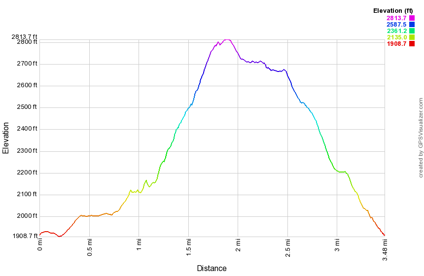 (The image at the left shows the profile of the hike. Remember that all vertical profiles are relative!)