
What You Missed
Spring 2024
Spring 2024
![]()
![]()
![]()
![]()
![]() On Friday, April 26th, I planned to do a hike to a 3500 foot peak. I chose Balsam Lake as it is close to my house and has a fire tower. I looked up the last time I had hiked a 3500 foot mountain and found I had not done one for all of 2023! Our ambulance calls sky-rocketed last year and I covered 760 calls meaning I averaged 2 a day. This is a lot for a volunteer in a volunteer agency! Fortunately, we have several more EMTs coming up and that will allow me to get back to hiking again. I had arranged for a driver and crew to cover calls so I was free to enjoy the hike. When I got up in the morning at 6:30 AM it was only 42 degrees so I knew I would need a jacket of some kind as the temperature at the trailhead would probably be cooler. The forecast was calling for temperatures to rise rapidly into the 60's. I was a little concerned about the hike as I did not know how I would handle the climbing and elevation gain but I knew BLM is relatively short. As I started to get ready at 9:15 AM Sheila was excited as she loves to be outside. I decided to wear my Mammut long-sleeved crew shirt with a long-sleeved baselayer. I put on a pair of RailRiders hiking pants which are expensive but last a long time and have features like deep pockets and a generous cut which I really like. I decided to put on my Keen Durand hiking boots which fit well. I added a new pair of Xstance insoles in an effort to find the best support and cushioning for my feet. These insoles have shock absorbing gel pads, TPU arch support, and memory foam cushioning all wrapped in a breathable fabric. The insoles have been hyped by their manufacturer and seemed to be living up to their claims. I grabbed a pair of Leki MicroVario poles I have been using for some time because they are light and lock without slipping. I did don my Mammut hoody which has lots of zippers to dump heat. This jacket has a hood but I decided to wear a light knit hat. I did put on my OR Crocodile gaiters as I knew the trail might be wet and muddy from the recent rains. I put on my Mammut hoody which has lots of zippers to dump heat if necessary. I put my gear in the back of the car and Sheila in the back seat and left the house at 9:45 AM. I headed toward Roscoe on Old Rt 17 and I turned right on the Beaverkill Road. I headed north toward Lew Beach and Turnwood. The Beaverkill Falls were flowing freely with a goof volume from the recent rains. The road conditions were pretty good but deteriorated when the pavement ended. The roads were dry and there was a lot of dust. I passed the White Castle and the Buddhist monastery and continued on toward the trailhead.
On Friday, April 26th, I planned to do a hike to a 3500 foot peak. I chose Balsam Lake as it is close to my house and has a fire tower. I looked up the last time I had hiked a 3500 foot mountain and found I had not done one for all of 2023! Our ambulance calls sky-rocketed last year and I covered 760 calls meaning I averaged 2 a day. This is a lot for a volunteer in a volunteer agency! Fortunately, we have several more EMTs coming up and that will allow me to get back to hiking again. I had arranged for a driver and crew to cover calls so I was free to enjoy the hike. When I got up in the morning at 6:30 AM it was only 42 degrees so I knew I would need a jacket of some kind as the temperature at the trailhead would probably be cooler. The forecast was calling for temperatures to rise rapidly into the 60's. I was a little concerned about the hike as I did not know how I would handle the climbing and elevation gain but I knew BLM is relatively short. As I started to get ready at 9:15 AM Sheila was excited as she loves to be outside. I decided to wear my Mammut long-sleeved crew shirt with a long-sleeved baselayer. I put on a pair of RailRiders hiking pants which are expensive but last a long time and have features like deep pockets and a generous cut which I really like. I decided to put on my Keen Durand hiking boots which fit well. I added a new pair of Xstance insoles in an effort to find the best support and cushioning for my feet. These insoles have shock absorbing gel pads, TPU arch support, and memory foam cushioning all wrapped in a breathable fabric. The insoles have been hyped by their manufacturer and seemed to be living up to their claims. I grabbed a pair of Leki MicroVario poles I have been using for some time because they are light and lock without slipping. I did don my Mammut hoody which has lots of zippers to dump heat. This jacket has a hood but I decided to wear a light knit hat. I did put on my OR Crocodile gaiters as I knew the trail might be wet and muddy from the recent rains. I put on my Mammut hoody which has lots of zippers to dump heat if necessary. I put my gear in the back of the car and Sheila in the back seat and left the house at 9:45 AM. I headed toward Roscoe on Old Rt 17 and I turned right on the Beaverkill Road. I headed north toward Lew Beach and Turnwood. The Beaverkill Falls were flowing freely with a goof volume from the recent rains. The road conditions were pretty good but deteriorated when the pavement ended. The roads were dry and there was a lot of dust. I passed the White Castle and the Buddhist monastery and continued on toward the trailhead.
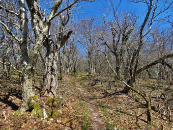 When I got to the "Seasonal Maintenance" sign, I was happy but hoped there would not be many cars coming from the opposite direction. The road was narrow but in good condition depsite the recent rains. We arrived at the parking area at 10:20 AM and found no other cars in the lot. I was a little surprised as it was Friday and the forecast was for a beautiful day. The temperature was 54 degrees. Sheila jumped out of the car and started to explore the parking area which was familiar. I decided to wear my Mammut hoody as I knew I could open zippers when I got warm and stow it in my pack if I needed to do so. The skies were bright blue without any clouds. I planned to take the hike slow as I wanted to make sure I did not tire myself out by going too fast. The trail was drier than I expected with out a few damp spots here and there. I noticed that several larger bloodworm had been cut and cleared and assumed a DEC crew had done the work. I stopped at the trail register to sign in. The trail register had been repaired from the pieces that were there on previous trips. As we walked up the trail, I noticed that it needed some trimming but was clear of major blowdowns. Walking was easy as the trail has only a slight incline until the turn up the mountain. I tried to keep a relaxed pace even though I felt I could have pushed harder. When got to the first trail junction, we started up the mountain and I could immediately feel the difference in the incline. I opened all the zippers on the hoody and was still warm.
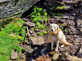
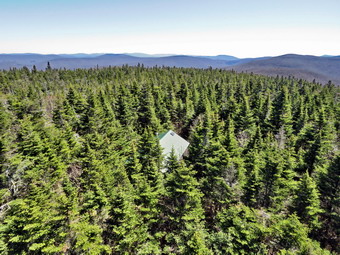
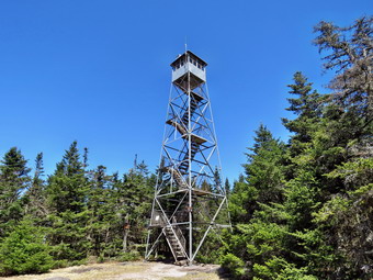 The first part of the trail is a gentle climb and I was feeling pretty good with an occasional stop for less than a minute to catch my breath. The trail was mostly dry but there were a few damp spots. Over the next half mile the trail gains about 750 feet before leveling off which means an average of around a 28% grade! The trail has a lot of rocks and roots with more and more being exposed by the erosion caused by more people using the trail. I also noted the trail was getting wider as people were not sticking with the established route. Sheila is always able to hike faster than I can and she was running far ahead on the trails and then taking off following game trails through the woods. We kept moving along with Sheila always ahead but not too far which encouraged me. The climb seemed shorter than I remembered even though I had not tried a sustained climb like this in a long time. Several times I thought we were near the trail to the lean-to but had another steep section to climb. Finally we reached the trail to the lean-to and continued straight up the hill through a short but steep climb. We passed the 3500 foot sign and the trail became a small stream from the spring just above. We arrived at the spring which was actually flowing better than I had expected. Sheila got a drink and I took picture of her at the spring and the spring itself. We left the spring and climbed the stone steps to the summit plateau where the trail flattens a little. All the steps were very wet and I was careful to use the poles and be sure of my foot placement. Once we were on the flatter part of the trail, I felt much better since we were not climbing. I stopped to take a few picures of the trail and the twisted trees all around us. On many peaks the 3500 foot elevation marks the beginning of the evergreen trees but not here. We continued on the trail and passed the Millbrook Ridge Trail to Alder Lake which is also the route of the FLT. I did stop to take a few shots of the trail through the balsam firs. As we continued on to the fire tower clearing, we passed the relocated privy on the right side of the trail. We arrived at the tower clearing at 11:45 AM after hiking 1.7 miles. The skies were still a bright blue but there were no clouds. There was a woman sitting at the picnic table so I put my pack down on the big rock. The woman and I exchanged greetings. She was from Margaretville and had parked at the Millbrook Road trailhead. I had not brought a leash for Sheila and resigned myself to the fact she would climb the tower with me. Unlike many other dogs, Sheila will climb all the way up the tower and back down! I walked over to the tower with my camera and started to climb. I saw that some of the steps had been replaced and were slightly wider and sturdier than the old ones. As I rose above the treeline, the breeze hit me and I raised my hood. I climbed to the top of the tower just below the locked cab. I took pictures of the surrounding landscape from the top of the tower in all directions. I missed having some puffy white clouds in the sky. I stopped on the landing just below the cab and looked around. The scene was beautiful and, as always, I knew that pictures could not do it justice. I took a number of shots of the trees and cabin below and then turned my attention to the mountains. I took shots in all directions getting pictures of the Devil's Path to the north and some of Graham. Eventually I was satisfied I had enough pictures and wanted to get back down. I walked back to my pack and put away my camera, took a drink and got out a bar.
 The woman at the picnic table started out ahead of us and I wondered how long it would take for us to catch her. We headed down the Millbrook side of the mountain at 11:55 AM. We walked down the trail on the other side of the mountain passing the cabin. The trail was very dry on the descent and covered in many small rocks which made things very "slippery". We met one woman coming up the trail so I pulled Sheila off to the side as she passed. She told me that there was a group coming up the trail with three dogs! When the trail flattened some, we came to areas which are usually muddy and were muddy this time. On one of the descents, we passed the woman who had been at the picnic table. A little farther along we met another man hiking toward us and each of us said "Hello". As we came to another flat area, I saw what looked like a golden retriever approaching with the owner just behind. He called the dog but the dog ignored him. Fortunately, the dog seemed friendly and exchanged sniffs with Sheila. I stayed where I was as another woman approached and told me there were two more dogs on the way. I waited until the owner leashed the dogs and passed by us. We continued on the trail and soon we were approaching the junction with the Dry Brook Ridge Trail that connects Millbrook Road to the Beaverkill Road. We passed through the gate at the bottom of the trail. We came to the trail junction with Sheila in the lead and I said to her "Back to the car" without making any signal Sheila immediately turned right and walked down the trail! There was a sign at the junction warning hikers to stay on the trails and that Graham Mountain was closed to all hikers. The trail has a lot of rocks but they were mostly dry. There isn't much to see on this return trip so I set a faster pace. I looked down to the Gulf of Mexico below and marveled at the steepness and extent of the descent. We encountered places where there had been some blowdowns and all had been cut and removed from the trail. There were also a few new blowdowns which were smaller and could be cut with hand tools. I looked down into the Gulf of Mexico several times but did not see or hear any water. The trail, which had been very narrow, was wider since more people were using it. After just less than a mile, we were back at the trail junction where we had turned up the mountain earlier. We continued on toward the car by retracing our steps. Along the way we met a family of three from Livingston Manor enjoying the nice weather. I signed out at the trail register and we continued to the parking area. We were back in the parking area at 1:10 PM after hiking 4.5 miles in 2 hours and 50 minutes with stops to rest, relax and take pictures. We had climbed 1200 feet in elevation. The temperature at the car was 62 degrees.
![]()
![]()
![]()
![]()
![]() On Tuesday, April 23rd, I wanted to get out and do a longer hike after weeks of covering ambulance calls. I called another EMT to cover for me so I was free to spend several hours hiking. I thought about going to balsam Lake Mountain as I had not hiked a mountain in some time. In the end I changed my mind as the drive to Balsam Lake Mountain was too long. I also wanted a hiking companion and knew Cindy would not want to climb a mountain. I decided that Alder Lake would be nice so I asked Cindy if she would like to go. She said "Yes" and we started to get ready at 9:15 AM with the temperature in the high 50's and plenty of sun and blue skies. I thought we would hike to the Beaver Meadow Lean-to which would be better named the Beaver Pond Lean-to as the beavers have returned. They have built an impressive dam and there are at least two lodges. I knew I could extend the hike by going to the falls on Alder Creek downstream of the lake. Sheila was hovering around me as she can always detect when I am getting ready for a hike. I decided to wear my Mammut long-sleeved crew shirt with a long-sleeved baselayer. I wore my Railriders hiking pants which are expensive but last along time and have features like deep pockets and a generous cut which I really like. The pants have Velcro closures at the ankles. I thought about warmer pants but decided against it. I decided to put on my Keen Durand hiking boots which fit well. I added a new pair of Xstance insoles in an effort to find the best support and cushioning for my feet. These insoles have shock absorbing gel pads, TPU arch support, and memory foam cushioning all wrapped in a breathable fabric. The insoles have been hyped by their manufacturer and seemed to be living up to their claims. I grabbed a pair of Leki MicroVario poles I have been using for some time because they are light and lock without slipping. I did don my Mammut hoody which has lots of zippers to dump heat. This jacket has a hood but I decided to wear a light knit hat. I did put on my OR Crocodile gaiters as I knew the trail might be wet and muddy from the recent rains. I got our gear and Sheila in my car and left Livingston Manor at 9:45 AM and drove north and west on Old Route 17 toward Roscoe. Just outside of town I turned right on the Beaverkill Road and headed north. I continued on the Beaverkill Road through Lew Beach and Turnwood toward Alder Creek Road where I made a left. I continued to the end on the road where I turned right toward Alder Lake. I drove up the access road very slowly as there are some very rough spots. When I got to the parking area there was one car in the upper parking area and one in the lower parking lot. The temperature was 54 degrees but the sun made it feel much warmer. The skies were bright and sunny with lots of blue but no puffy white clouds. We started out on the path toward the "lawn" at 10:05 AM.
On Tuesday, April 23rd, I wanted to get out and do a longer hike after weeks of covering ambulance calls. I called another EMT to cover for me so I was free to spend several hours hiking. I thought about going to balsam Lake Mountain as I had not hiked a mountain in some time. In the end I changed my mind as the drive to Balsam Lake Mountain was too long. I also wanted a hiking companion and knew Cindy would not want to climb a mountain. I decided that Alder Lake would be nice so I asked Cindy if she would like to go. She said "Yes" and we started to get ready at 9:15 AM with the temperature in the high 50's and plenty of sun and blue skies. I thought we would hike to the Beaver Meadow Lean-to which would be better named the Beaver Pond Lean-to as the beavers have returned. They have built an impressive dam and there are at least two lodges. I knew I could extend the hike by going to the falls on Alder Creek downstream of the lake. Sheila was hovering around me as she can always detect when I am getting ready for a hike. I decided to wear my Mammut long-sleeved crew shirt with a long-sleeved baselayer. I wore my Railriders hiking pants which are expensive but last along time and have features like deep pockets and a generous cut which I really like. The pants have Velcro closures at the ankles. I thought about warmer pants but decided against it. I decided to put on my Keen Durand hiking boots which fit well. I added a new pair of Xstance insoles in an effort to find the best support and cushioning for my feet. These insoles have shock absorbing gel pads, TPU arch support, and memory foam cushioning all wrapped in a breathable fabric. The insoles have been hyped by their manufacturer and seemed to be living up to their claims. I grabbed a pair of Leki MicroVario poles I have been using for some time because they are light and lock without slipping. I did don my Mammut hoody which has lots of zippers to dump heat. This jacket has a hood but I decided to wear a light knit hat. I did put on my OR Crocodile gaiters as I knew the trail might be wet and muddy from the recent rains. I got our gear and Sheila in my car and left Livingston Manor at 9:45 AM and drove north and west on Old Route 17 toward Roscoe. Just outside of town I turned right on the Beaverkill Road and headed north. I continued on the Beaverkill Road through Lew Beach and Turnwood toward Alder Creek Road where I made a left. I continued to the end on the road where I turned right toward Alder Lake. I drove up the access road very slowly as there are some very rough spots. When I got to the parking area there was one car in the upper parking area and one in the lower parking lot. The temperature was 54 degrees but the sun made it feel much warmer. The skies were bright and sunny with lots of blue but no puffy white clouds. We started out on the path toward the "lawn" at 10:05 AM.
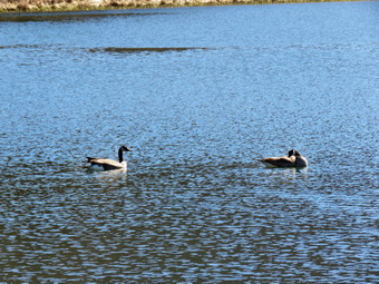
 We walked along the path which passes by the stone foundations which marks the last remnants of the Coykendall Mansion. The house had been built as a large hunting lodge and then was gifted to the Boy Scouts of America. When the state took over the property, the mansion fell into disrepair with campers tearing boards away to use for campfires. The state added a fence but it did not deter people so the house was eventually burned to the ground. As we walked down the right side of the lawn, I noticed that the grass was short as it had no grown up yet and the picnic tables that were present were easily accessible. I walked toward the dam and the "beach" where I normally take pictures. I took out my camera and snapped some shots of the lake and the hills around it. The sun was bright and was making it difficult to get good shots. The sunlight bouncing off the lake was causing the ripples in the water to sparkle. I was almost done photographing when two geese took off from shore and landed on the water. I took some shots as they swam away from shore. We walked across the lawn toward the trail around the left side of the lake and started walking east along the trail on the north side of the lake. The trail was wet in many places with a few muddy spots. The brush and branches that had overgrown the trail were now dead and the walking was much easier but some still hung in the path. This reminded me that I should call my maintainer for this trail to see if he intended to work on it. The small streams that cross the trail had some water in them. Sheila was happy to be out and ran ahead and then returned to us. Mostly she was happy to walk along between us. I began to remove small branches from the trail and moved one larger one. I stopped for a moment to take some pictures of Cradle Rock Ridge on the other side of the lake. There was also an old beaver lodge near the shore and I took some pictures.
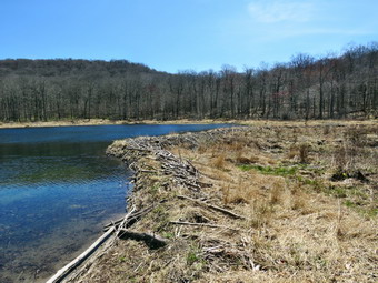 We continued on the trail and we crossed the bridges on the trail near the head end of the lake. I could see the beaver dam that impounded some water from the inlet streams was still intact. I stopped to take pictures of the dam and the water behind it. We continued on the trail toward the junction with the Millbrook Ridge Trail. At the point where a path leads to the left to some primitive campsite, a large tree that had fallen across the trail was still lying on the ground. We were able to step over them but it was not easy. I could cut them with my hand tools but it would take a long time! I made a note to call the local ranger to see if we could schedule a time to remove them with a chainsaw. At the trail junction, we turned left to head toward the lean-to on the Millbrook Ridge Trail. The trail was wet in some places and muddy in quite a few areas. Fortunately, the trail showed more use than I had expected and was relatively clear of blowdowns and branches. There were a few small blowdowns which I removed from the trail. There were also some older and rotten trunks that I was able to move and this continued for the rest of the hike. I did find a few blowdowns that I had cut and a few more that should be cut. We crossed some streams that run across the trail and were now flowing nicely. Alder Creek had quite a bit of water and we could here it as it ran downstream over the rocks. The sunlight was sparkling off the water and the lack of leaves on the trees allowed us to get some great views. some of the large, older blowdowns which had been across the trail had been cleared. The trail is pretty obvious and the blazes easy to see in most places. For the next 1.5 miles the trail climbed and then leveled off several times. The elevation gain is several hundred feet but the grade is never more than 12% and averages around 6%. There isn't too much to see along the way but this day was very pleasant because of the temperature and my mood.
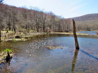
 The trail leveled off at the first beaver meadow and I decided to walk out to the edge of the meadow to take some pictures. The meadow was larger than I had thought. I returned to the trail and we crossed a small stream. Sheila took the time to get a drink and splash in the water. At 2.2 miles we began the last climb and I found that the going was easier than I thought it would be. Cindy on the other hand was getting tired and wanted to stop and wait for me. I encouraged her and she continued to walk. As we started the climb, we came across a few more blowdowns. Soon we arrived at the beaver pond. Where there had once been a beaver meadow, there was now a pond with a dam and a beaver lodge. The pond was lower than the last time I had visited but still occupied the entire meadow. As we came to the spot on the trail opposite the beaver dam, I walked off the trail to the right and found a good viewpoint. I took pictures of the pond and the dam which I thought would be good as there were reflections in the pond. I also took some shots of the beaver lodge with the lean-to in the background. As I looked around I was overcome by the feeling of joy at seeing what God has created! I realized that the return trip would be much easier as it was almost all downhill. Cindy had walked along the shore of the pond to a big rock where she had seated herself for a snack. I sat down beside her and ate a bar and had a drink. It was 11:45 AM and it had taken us 1 hour and 40 minutes to get to the pond. Sheila decided to take a swim and then come shake herself off next to us. After we got a drink and a snack, Sheila began zooming around us and jumping over us. At 11:55 AM, we decided we would turn around and return to the car. We walked out to the main trail and turned left and started back to the parking area. The walk was all downhill or flat so it did go quickly. It also helped that I was not taking any pictures! We were soon at the loop trail around Alder Lake where we turned right to return the way we came.
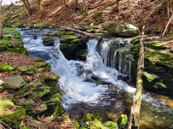
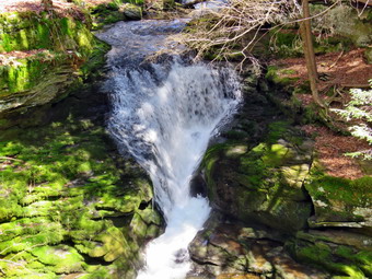 We crossed the bridges and found an open view of Cradle Rock Ridge. We continued on the trail toward the parking area. We walked up the hill toward the ruins of the lodge and then toward the parking area. As we approached the parking area, I noted that it had taken only 70 minutes to walk back to the parking area. I decided I had just enough time to walk down to Alder Creek to visit the waterfalls and take some pictures. Cindy went to the car while Sheila and I turned left on the path that leads down to the spring and then right to walk downstream along the creek. I stopped when we came to the first small waterfall. I got out my camera and walked to the flat rocks along the streambed. I took some pictures of the rapids upstream and then walked a little farther downstream. I was able to get some shots of a small falls and one that is about 10 feet tall. I went back to my pack, stowed the camera and walked back up the bank to one of the woods roads. We walked downstream on the woods road until I found a path that I knew led down to the stream. We walked down the path to a viewpoint over the highest falls which drops about 20 feet. There was plenty of water flowing in the creek and the lighting was not too bad. I took a number of pictures including some of a smaller falls below the main one. When I was done, I decided it was time to go back to the car. We walked back up the path to the woods road and followed it back to the path and the parking area. We were back at the car at 1:20 PM after hiking 5.0 miles in 3 hours and 15 minutes with 30 minutes of stopped time. The elevation gain was 800 feet. Our moving speed was 2 MPH.
![]()
![]()
![]()
![]() On Monday, April 22nd I planned to get out for a hike but found that a member of Highland EMS would be at our building to respond to calls for their EMT class. I changed my plans, met with the EMT student and gave her a tour of our rigs. I waited around the rest of the day for a call and, fortunately, we got one a little after 1300. After returning from the call, I reviewed it with the student and we both left the building. I had almost given up on taking a walk but decided I would go across the street to hike on Round Top. At 4:15 PM I began to get ready with the temperature at 60 degrees on the back porch with partly sunny skies. As I began to get ready, Sheila was keeping a careful eye on me as I dressed as she would hike every day. Sheila often examines and sniffs my clothing to make sure I am serious about hiking. I decided to wear my Mammut long-sleeved crew shirt without a baselayer due to the warm temperature. I wore my Railriders hiking pants which are expensive but last along time and have features like deep pockets and a generous cut which I really like. The pants have Velcro closures at the ankles. I decided to put on my Keen Durand hiking boots which I ordered a half size larger than the previous pair. These shoes fit well out of the box but get much tighter when I add a decent insole. Without the third party insole, by feet hurt from the lack of support. I added a new pair of Xstance insoles in an effort to find the best support and cushioning for my feet. These insoles have shock absorbing gel pads, TPU arch support, and memory foam cushioning all wrapped in a breathable fabric. The insoles have been hyped by their manufacturer and they really do seem to deliver. I did decide to wear my Mammut hoody as I did not like many of the lighter jackets I have. The hoody has pit zips that open all the way to the lower hem. I did not bother with a hat or gloves. I decided to take my Leki poles with external locks as the internal twist locks sometimes fail. I did not put on gaiters as I knew there would be no snow, ice or mud. I took my cell phone with me because even though I planned to hike quickly, I was pretty sure I was the only EMT around to respond. At 4:30 PM we walked out the door to start the hike. I grabbed Sheila's leash from my car and put it on her as we walked up the driveway. I aimed to hike for about a little over an hour and complete two figure 8's. Sheila was happy to get out as we headed down the driveway and across the street. We crossed the street and walked to the parking lot next to the Presbyterian Church. We walked to the back of the church and began the ascent of the steepest hill behind the church. The hill is short but gets the circulation pumping and is the steepest and longest climb on the "trail." I let Sheila off her leash so I could use my poles and did stop not on the way to the top of the hill. I could really feel that I had been hiking more consistently. At the top we paused for a minute so I could look around at the hills that surround the hamlet of Livingston Manor. The skies were a mixture of clouds and sun. We continued the hike by turning left at the trailhead. The trail was covered in leaves and damp in some places.
On Monday, April 22nd I planned to get out for a hike but found that a member of Highland EMS would be at our building to respond to calls for their EMT class. I changed my plans, met with the EMT student and gave her a tour of our rigs. I waited around the rest of the day for a call and, fortunately, we got one a little after 1300. After returning from the call, I reviewed it with the student and we both left the building. I had almost given up on taking a walk but decided I would go across the street to hike on Round Top. At 4:15 PM I began to get ready with the temperature at 60 degrees on the back porch with partly sunny skies. As I began to get ready, Sheila was keeping a careful eye on me as I dressed as she would hike every day. Sheila often examines and sniffs my clothing to make sure I am serious about hiking. I decided to wear my Mammut long-sleeved crew shirt without a baselayer due to the warm temperature. I wore my Railriders hiking pants which are expensive but last along time and have features like deep pockets and a generous cut which I really like. The pants have Velcro closures at the ankles. I decided to put on my Keen Durand hiking boots which I ordered a half size larger than the previous pair. These shoes fit well out of the box but get much tighter when I add a decent insole. Without the third party insole, by feet hurt from the lack of support. I added a new pair of Xstance insoles in an effort to find the best support and cushioning for my feet. These insoles have shock absorbing gel pads, TPU arch support, and memory foam cushioning all wrapped in a breathable fabric. The insoles have been hyped by their manufacturer and they really do seem to deliver. I did decide to wear my Mammut hoody as I did not like many of the lighter jackets I have. The hoody has pit zips that open all the way to the lower hem. I did not bother with a hat or gloves. I decided to take my Leki poles with external locks as the internal twist locks sometimes fail. I did not put on gaiters as I knew there would be no snow, ice or mud. I took my cell phone with me because even though I planned to hike quickly, I was pretty sure I was the only EMT around to respond. At 4:30 PM we walked out the door to start the hike. I grabbed Sheila's leash from my car and put it on her as we walked up the driveway. I aimed to hike for about a little over an hour and complete two figure 8's. Sheila was happy to get out as we headed down the driveway and across the street. We crossed the street and walked to the parking lot next to the Presbyterian Church. We walked to the back of the church and began the ascent of the steepest hill behind the church. The hill is short but gets the circulation pumping and is the steepest and longest climb on the "trail." I let Sheila off her leash so I could use my poles and did stop not on the way to the top of the hill. I could really feel that I had been hiking more consistently. At the top we paused for a minute so I could look around at the hills that surround the hamlet of Livingston Manor. The skies were a mixture of clouds and sun. We continued the hike by turning left at the trailhead. The trail was covered in leaves and damp in some places.
We passed by all the places where I had cut trees to remove them from the trail. At the first trail junction, I said "Right" and followed Sheila as she turned right and started up the woods road which has the gentler approach of the two. There were a number of small branches on the trail from the winds that had passed through the area. I removed these branches either by dragging them off the trail. It was a pleasure to walk on the trails and it was obvious more people were using them. At the end of the woods road, we turned left up the hill on the trail. I could see the frame and tarps that covered the mouth of one of the "caves". It looked like someone had cleaned up the area and might be using it again. We continued up the trail to the first trail junction with the upper blue trail where we turned left to follow the yellow trail along the base of Round Top. We continued on the yellow trail along the base of Round Top. We came to the next junction with the blue trail and turned right to head up the blue trail toward the summit. When we got to the switchback, we turned right and followed it until it came back to the main blue trail. The fact that the switchback sidehills in places made the walk a little more difficult. We turned right and then continued straight ahead and up the hill toward the summit of Round Top bypassing the white crossover trail. As we walked over the high point, I removed a couple of branches from the trail. We continued over the summit and down the blue trail toward the junction with the yellow trail. We bypassed the white crossover trail again and continued down to the yellow trail. At the junction with the yellow trail we turned right and walked the yellow trail along the base of Round Top toward the next junction with the blue trail. At the next junxtion, we turned left and started slightly downhill toward the lookout over town. We passed the "sitting rock" and continued downhill.
When we reached the lookout, we followed the yellow trail as it turned left and walked down the hill to the first trail junction. We immediately turned around and started back up the trail. I could feel that I was out of shape but I did not have to stop to get up the hill. We ignored the trail to the lower lookout and followed the yellow trail. We followed the yellow trail as it turned right and headed uphill toward the junction with the blue trail. We hiked up a short but steep little hill and arrived at the trail junction. We turned right to follow the trail along the base of Round Top. We again passed under the blowdown and arrived at the next junction with the blue trail. We turned left to start the walk up the blue trail toward the summit. I was going to simply continue over the summit but Sheila had other ideas. Sheila turned left on the white crossover trail as if she wanted to make sure I inspected it. We continued to walk along the white trail until it met the main blue trail on the other side of the hill. There were no blowdowns blocking the trail. We turned left and left again on the switchback in the blue trail. We followed the switchback out into the forest and then back to the main trail. We turned left and walked downhill to the yellow trail where a left turn again took us along the base of Round Top and under the blowdown on the trail. At the junction, Sheila and I turned right and walked down the trail to the woods road. We followed the woods road downhill with the ledges to the right. At the first trail junction, we turned left and walked straight out to the trailhead. We turned right and walked downhill and crossed the parking lot to the road. We waited to cross the road as several cars went by and then crossed to the driveway to the house. It was 5:40 PM and we had hiked a little over 2 miles in 1 hour and 10 minutes. It was a pleasant hike and there had been no ambulance calls!
![]()
![]()
![]()
![]() On Saturday, April 20th I was awakened by a morning ambulance call. When I went to sleep, it was still raining but when I woke up the rain had stopped and there was some sun along with clouds. When I returned home, I decided to go across the street and hike on Round top since I could still respond on calls. I began to get ready with the temperature at 53 degrees on the back porch. As I began to get ready, Sheila was running around barking at my every move as we had not been out for four days due to rain and other commitments. Sheila often examines and sniffs my clothing to make sure I am serious about hiking. I decided to wear my Mammut long-sleeved crew shirt but without a baselayer. I wore my Railriders hiking pants which are expensive but last along time and have features like deep pockets and a generous cut which I really like. The pants have Velcro closures at the ankles. I decided to put on my Keen Durand hiking boots which I ordered a half size larger than the previous pair. These shoes fit well out of the box but get much tighter when I add a decent insole. Without the third party insole, by feet hurt from the lack of support. I added a new pair of Xstance insoles in an effort to find the best support and cushioning for my feet. These insoles have shock absorbing gel pads, TPU arch support, and memory foam cushioning all wrapped in a breathable fabric. The insoles have been hyped by their manufacturer and they really do seem to deliver. I decided to take my Leki poles with external locks as the internal twist locks sometimes fail. I donned my Mammut hoody for the pockets I needed to stow some gear. It has pit zips that open all the way to the lower hem. I decided to take my Leki poles with external locks as the internal twist locks sometimes fail. I decided I did not need a hat or gloves. I brought along my phone in case there were any calls. At 11:30 AM we walked out the door to start the hike. I grabbed Sheila's leash from my car and put it on her as we walked up the driveway. I aimed to hike for about a little over an hour and complete two figure 8's. Sheila was happy to get out as we headed down the driveway and across the street. We crossed the street and walked to the parking lot next to the Presbyterian Church. The parking lot was packed with cars even though it was not Sunday. We walked to the back of the church and began the ascent of the steepest hill behind the church. I released Sheila from her leash so I could use my poles effectively. The hill is short but gets the circulation pumping and is the steepest and longest climb on the "trail." I did not have to stop once on the way to the top of the hill and the trip went quickly. At the top we paused for a minute so I could look around at the hills that surround the hamlet of Livingston Manor.
On Saturday, April 20th I was awakened by a morning ambulance call. When I went to sleep, it was still raining but when I woke up the rain had stopped and there was some sun along with clouds. When I returned home, I decided to go across the street and hike on Round top since I could still respond on calls. I began to get ready with the temperature at 53 degrees on the back porch. As I began to get ready, Sheila was running around barking at my every move as we had not been out for four days due to rain and other commitments. Sheila often examines and sniffs my clothing to make sure I am serious about hiking. I decided to wear my Mammut long-sleeved crew shirt but without a baselayer. I wore my Railriders hiking pants which are expensive but last along time and have features like deep pockets and a generous cut which I really like. The pants have Velcro closures at the ankles. I decided to put on my Keen Durand hiking boots which I ordered a half size larger than the previous pair. These shoes fit well out of the box but get much tighter when I add a decent insole. Without the third party insole, by feet hurt from the lack of support. I added a new pair of Xstance insoles in an effort to find the best support and cushioning for my feet. These insoles have shock absorbing gel pads, TPU arch support, and memory foam cushioning all wrapped in a breathable fabric. The insoles have been hyped by their manufacturer and they really do seem to deliver. I decided to take my Leki poles with external locks as the internal twist locks sometimes fail. I donned my Mammut hoody for the pockets I needed to stow some gear. It has pit zips that open all the way to the lower hem. I decided to take my Leki poles with external locks as the internal twist locks sometimes fail. I decided I did not need a hat or gloves. I brought along my phone in case there were any calls. At 11:30 AM we walked out the door to start the hike. I grabbed Sheila's leash from my car and put it on her as we walked up the driveway. I aimed to hike for about a little over an hour and complete two figure 8's. Sheila was happy to get out as we headed down the driveway and across the street. We crossed the street and walked to the parking lot next to the Presbyterian Church. The parking lot was packed with cars even though it was not Sunday. We walked to the back of the church and began the ascent of the steepest hill behind the church. I released Sheila from her leash so I could use my poles effectively. The hill is short but gets the circulation pumping and is the steepest and longest climb on the "trail." I did not have to stop once on the way to the top of the hill and the trip went quickly. At the top we paused for a minute so I could look around at the hills that surround the hamlet of Livingston Manor.
We entered the woods at the trailhead and continued on to the first junction. The trail was damp and a little slippery in places. Sheila and I both seemed to have the same idea as I wanted to go straight up to the lookout and Sheila chose that path. Climbing the hill seemed easy but I did slip a few times. When we reached the top of the hill, we followed the yellow trail as it continued passed the upper part of the lookout. Where the trail turned right we followed it uphill passing through a large area of dead ferns. Some trees were showing what looked like buds which I took to be a sure sign of spring! We passed the sitting rock and continued uphill to the junction with the blue trail. We turned right to follow the yellow trail along the base of Round Top. As we walked the old woods road, I found several bushes and small trees hanging into the trail. I made a note to bring a set of loppers next time. I also noticed that many of the paint blazes need a touch up. As we continued to the next junction with the blue trail, we came to the spot where a medium sized birch tree had fallen across the trail. On our last trip I had removed this blowdown from the trail. At the junction with the blue trail, we turned right to climb the trail toward the summit. We passed by the white crossover trail and continued over the summit. We started down the other side slipping a little and bypassing the white trail. We did turn left on the switchback in the blue trail. We followed it out into the woods and back again to the blue trail farther down the hill. We turned left on the main blue trail and walked downhill until we were back at the junction with the yellow trail. We turned left and again walked along the yellow trail to the next junction with the blue trail. This time we turned right and started to walk down the trail to the woods road. Sheila and I started down the woods road at a quick pace passing another blowdown that had been lying across the trail. This larger blowdown I had also removed on our previous trip.
When we reached the first trail junction, I debated not doing another figure 8 as I was teaching a CPR course at 2:00 PM and wanted to go home to take a shower. I decided I wanted to get a little more exercise! We turned around and started back up the woods road we had just descended. We set a faster pace up the woods road and turned left to stay on the yellow trail as the woods road ended. At the junction with the blue trail we turned left to stay on the yellow trail along the base of Round Top. We walked passed by the fallen birch tree and passed by some bushes that were still hanging into the trail. At the second junction with the blue trail, we turned right and began to ascend the hill. We turned right where the switchback led us out into the forest and then back to the main blue trail. We turned right and headed for the summit but immediately turned right om the white crossover trail. We walked along the trail checking for blowdowns and brush in the trail. At the junction with the blue trail, we turned right and headed down the other side. At the base of the hill we turned right on the yellow trail and again walked along the base of Round Top to the second junction with the blue trail. This time we turned left and headed down the yellow trail toward the lookout. At the viewpoint where the yellow trail turned left we followed it and walked down the hill to the very first trail junction. We continued to walk straightahead out to the trailhead where we turned right. I put Shiela on her leash and we walked downhill to the road behind the church. We walked out through the parking lot and across the street to our driveway. We were back home at 12:30 PM after hiking just over 2 miles in 1 hour.
![]()
![]()
![]()
![]()
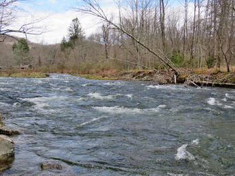
![]() On Thursday, March 14th, I wanted to get out for a short hike near home for the exercise and for the relaxation. I also knew that the forecast was for rain later in the week. I thought about going to the Beaverkill Campgrounds to see the level of the water in the stream after the recent rains. I asked Cindy if she wanted to go and she agreed. As we started to get ready at 12:00 PM the temperature was 58 degrees on the back porch with sunny skies and some puffy white clouds. As usual, Sheila was excited but was trying to be the "good dog". I got dressed in my Mammut crew top but decided against a baselayer. I wore my Railriders hiking pants which are expensive but last along time and have features like deep pockets and a generous cut which I really like. The pants have Velcro closures at the ankles. I decided to put on my Keen Durand hiking boots which I ordered a half size larger than the previous pair. These shoes fit well out of the box but get much tighter when I add a decent insole. Without the third party insole, by feet hurt from the lack of support. I added a new pair of Xstance insoles in an effort to find the best support and cushioning for my feet. These insoles have shock absorbing gel pads, TPU arch support, and memory foam cushioning all wrapped in a breathable fabric. The insoles have been hyped by their manufacturer and they really do seem to deliver. I decided to take my Leki poles with external locks as the internal twist locks sometimes fail. I donned my Mammut hoody for the pockets I needed to stow some gear. It has pit zips that open all the way to the lower hem. I did put on a light hat and took a pair of light knitted gloves which I knew I probably not need. I brought along my phone but resolved to leave it in the car as there is no service in the area anyway. I put our gear in the back of the car and Sheila in the back seat and we left the house at 12:20 PM. I drove out Old Route 17 toward Roscoe and turned right on Beaverkill Road. As we started the descent into the Beaverkill Valley, I turned left on Campsite Road and followed it down to the parking area near the Beaverkill Covered Bridge. There was one car parked in the lot as I pulled in and parked. A glance at the river showed that the level was as high as it had been this year. The sandy beach was barely visible and the rock I usually stand on to take pictures was under a considerable amount of water.
On Thursday, March 14th, I wanted to get out for a short hike near home for the exercise and for the relaxation. I also knew that the forecast was for rain later in the week. I thought about going to the Beaverkill Campgrounds to see the level of the water in the stream after the recent rains. I asked Cindy if she wanted to go and she agreed. As we started to get ready at 12:00 PM the temperature was 58 degrees on the back porch with sunny skies and some puffy white clouds. As usual, Sheila was excited but was trying to be the "good dog". I got dressed in my Mammut crew top but decided against a baselayer. I wore my Railriders hiking pants which are expensive but last along time and have features like deep pockets and a generous cut which I really like. The pants have Velcro closures at the ankles. I decided to put on my Keen Durand hiking boots which I ordered a half size larger than the previous pair. These shoes fit well out of the box but get much tighter when I add a decent insole. Without the third party insole, by feet hurt from the lack of support. I added a new pair of Xstance insoles in an effort to find the best support and cushioning for my feet. These insoles have shock absorbing gel pads, TPU arch support, and memory foam cushioning all wrapped in a breathable fabric. The insoles have been hyped by their manufacturer and they really do seem to deliver. I decided to take my Leki poles with external locks as the internal twist locks sometimes fail. I donned my Mammut hoody for the pockets I needed to stow some gear. It has pit zips that open all the way to the lower hem. I did put on a light hat and took a pair of light knitted gloves which I knew I probably not need. I brought along my phone but resolved to leave it in the car as there is no service in the area anyway. I put our gear in the back of the car and Sheila in the back seat and we left the house at 12:20 PM. I drove out Old Route 17 toward Roscoe and turned right on Beaverkill Road. As we started the descent into the Beaverkill Valley, I turned left on Campsite Road and followed it down to the parking area near the Beaverkill Covered Bridge. There was one car parked in the lot as I pulled in and parked. A glance at the river showed that the level was as high as it had been this year. The sandy beach was barely visible and the rock I usually stand on to take pictures was under a considerable amount of water.
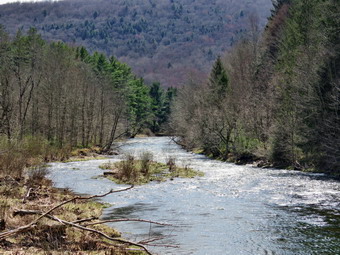
 We started our hike at 12:35 PM by walking out of the parking lot to the bridge with the temperature at 56 degrees. The bridge that had been closed after a car hit it and did some damage was now open. When we got to the other side, I looked at the trail and saw that it was completely bare but had some water running down and across the bottom of hill. We turned left on a woods road that parallels the river and started down the short hill. I had decided to take some pictures on the way out so when we got to the spring house on the right I stopped and got out the camera. I took some shots of the spring house and then turned my attention to the small stream that ran from it into the river. This shallow stream was covered in duck weed which was a bright green. I took several pictures at different zooms before packing up to cointinue the hike. When we got to the first culvert, I followed a path down to the edge of the stream. I took some pictures upstream catching the bridge and the white water of the rapids which were very pronounced. I took a few more shots with different zooms. I also took some pictures downstream and one of the water coming out of the culvert. When I was done, I packed away the camera and walked up to the woods road. We continued on the deserted woods road. We could hear the river and see the whitecaps on the water. I looked up to see a hiker coming toward us with his dog. We both paused to put our dogs on leashes and then passed by each other. Even though the landscape was bleak the sunlight and blue skies added an interesting dimension. The whole area had a serene feel enhanced by the sound of the flowing water. On the trail we passed by several areas with picnic tables. TheSe tables sit unused and rotting along the road, a testimony to better days when this area had camping areas. Now this area is used for day use. We walked by more tables which had not been used in years. A little later we came to what was once a bathroom for some campsites that had long since disappeared. There were more tables in this area. We stopped and I walked to the stream where rocks had been piled up and contained by wire screen. I walked to the edge and stood on some rocks to take more pictures of the stream in both directions. Sheila came over and stood on the wall next to me. The rapids in this area were really pronounced and the sunlight was playing off the water. I returned to the picnic table where I left my pack and took a few shots of the bathroom and the woods road before we contiuned on the woods road. At about .7 miles into the hike the woods road met the paved road that serves the campsites. I stopped to take some pictures of the campsites without any snow and with the lighting from the sun. We continued on the road through the campsites and along the river. Many of the campsites have a cement block fireplace with a grill but some were upgraded to poured concrete. Everything was very quiet except for the water in the river. This was not surprising as the campsites were closed. There were several trees that had been felled and bucked by state employees that maintian the campgrounds.
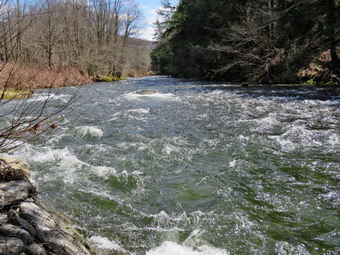
 We walked along the paved road to the last campsite where the road ends and I walked down to the edge of the river. I was careful to watch where I was walking as I did not want to slip into the cold water. Sheila decided it was warm enough to take a swim! I tried to get a few shots of her in the water. I stopped to take some pictures of the river especially downstream. When Sheila came out of the water, she did not seem to be cold but did start to run around. We continued a little further passed the last campsite and walked a path along the river. I took some shots downstream where the river turned to the left. The water was very clear with a pronounced greenish tint from looking through to the bottom. As we walked back passed the last campsite, we continued on the campsite road toward the last bathroom. When the road split, we stayed to the left to walk the parallel section of road back through the campsites. This road parallels the one we walked out on to make a sort of loop. We stopped near the end of the road where it starts up to the Berry Brook Road. I wanted to explore the area along the ridge that parallels the road. It was clear to me that Cindy did not want to go on an adventure so we continued along the woods road. This had happened before so I knew that if I was going to explore it would have to be when Cindy was not with me. We returned the way we had come although at a quicker pace. We continued our hike and I began to look to the left where the land rose out of the valley to a ridge. I could see that the land leveled off part of the way up and then started up again. I had walked up a path to this area on a previous hike and had no intention of trying it again as I was looking for something new. I had wanted to start further back but will save that for another time. We passed the spring house on the main campsite road. We walked up the hill to the road and turned right to walk through the bridge. At the end of the bridge, we turned right to head back to the car. Cindy got in the car and I stowed my poles and my pack. I got out the camera and Sheila and I walked over to the river. It was hard to find a place to stand to take pictures. We worked our way across a finger of the stream to a spit of land near the rock where I normally stand. I took pictures downstream where the rapids were really rolling. When I was done, we took a different route back to the car. We were back at the car at 1:50 PM having hiked 2.8 miles in 1 hour and 15 minutes with plenty of stopped time for pictures. The car's thermometer read 58 degrees.

![]() On Tuesday, April 9th I planned to get out to trim some trees on Round Top and the Parksville Rail Trail. At 12:30 PM I began to get ready with the temperature at 76 degrees on the back porch with sunny skies. I knew the actual temperature would be lower as the sensor on the back porch is in the sun. I decided I would take Sheila with me and asked Cindy if she would like to come to help me trim the trees. I was a little surprised when she was not interested since we had a good time the last time we worked together. As I began to get ready, Sheila was keeping a careful eye on me as I dressed as she would hike every day. Sheila often examines and sniffs my clothing to make sure I am serious about hiking. I decided to wear my Mammut long-sleeved crew shirt without a baselayer due to the warm temperature. I wore my Railriders hiking pants which are expensive but last along time and have features like deep pockets and a generous cut which I really like. The pants have Velcro closures at the ankles. I decided to put on my Keen Durand hiking boots which I ordered a half size larger than the previous pair. These shoes fit well out of the box but get much tighter when I add a decent insole. Without the third party insole, by feet hurt from the lack of support. I added a new pair of Xstance insoles in an effort to find the best support and cushioning for my feet. These insoles have shock absorbing gel pads, TPU arch support, and memory foam cushioning all wrapped in a breathable fabric. The insoles have been hyped by their manufacturer and they really do seem to deliver. I did decide to wear my Mammut hoody as I did not like any of the lighter jackets I have. It has pit zips that open all the way to the lower hem. I did put on a light hat but did not take any gloves. I decided not to take any hiking poles as I would be carrying an ax and saws. I did put on gaiters as I thought there might be some mud. I took my cell phone with me because even though I planned to hike quickly, I was pretty sure I was the only EMT around to respond. I put my Silky Sugowaza in my pack and brought my Fiskars ax which I had just sharpened. At 1:00 PM we walked out the door and to the car where I put Sheila in the back seat and my pack and ax in the back of the car. I drove out the driveway and turned right and then left to head up Orchard Street to the trailhead at the top of the cemetery. I grabbed Sheila's leash, my pack and the ax from my car and started the hike by walking up the steps at the trailhead. The trail was covered in leaves but there was no snow or mud.
On Tuesday, April 9th I planned to get out to trim some trees on Round Top and the Parksville Rail Trail. At 12:30 PM I began to get ready with the temperature at 76 degrees on the back porch with sunny skies. I knew the actual temperature would be lower as the sensor on the back porch is in the sun. I decided I would take Sheila with me and asked Cindy if she would like to come to help me trim the trees. I was a little surprised when she was not interested since we had a good time the last time we worked together. As I began to get ready, Sheila was keeping a careful eye on me as I dressed as she would hike every day. Sheila often examines and sniffs my clothing to make sure I am serious about hiking. I decided to wear my Mammut long-sleeved crew shirt without a baselayer due to the warm temperature. I wore my Railriders hiking pants which are expensive but last along time and have features like deep pockets and a generous cut which I really like. The pants have Velcro closures at the ankles. I decided to put on my Keen Durand hiking boots which I ordered a half size larger than the previous pair. These shoes fit well out of the box but get much tighter when I add a decent insole. Without the third party insole, by feet hurt from the lack of support. I added a new pair of Xstance insoles in an effort to find the best support and cushioning for my feet. These insoles have shock absorbing gel pads, TPU arch support, and memory foam cushioning all wrapped in a breathable fabric. The insoles have been hyped by their manufacturer and they really do seem to deliver. I did decide to wear my Mammut hoody as I did not like any of the lighter jackets I have. It has pit zips that open all the way to the lower hem. I did put on a light hat but did not take any gloves. I decided not to take any hiking poles as I would be carrying an ax and saws. I did put on gaiters as I thought there might be some mud. I took my cell phone with me because even though I planned to hike quickly, I was pretty sure I was the only EMT around to respond. I put my Silky Sugowaza in my pack and brought my Fiskars ax which I had just sharpened. At 1:00 PM we walked out the door and to the car where I put Sheila in the back seat and my pack and ax in the back of the car. I drove out the driveway and turned right and then left to head up Orchard Street to the trailhead at the top of the cemetery. I grabbed Sheila's leash, my pack and the ax from my car and started the hike by walking up the steps at the trailhead. The trail was covered in leaves but there was no snow or mud.
 We passed by all the places where I had cut trees to remove them from the trail. At the first trail junction, I said "Right" and followed Sheila as she turned right and started up the woods road which has the gentler approach of the two. There were a number of small branches on the trail from the winds that had passed through the area. I removed these branches either by dragging them off the trail. It was a pleasure to walk on the trails and it was obvious more people were using them. Just before we reached the end of the woods road, we came to a medium-sized trunk across the trail. I put my pack down and retrieved the camera to take my "before" pictures. After this I unsheathed the axe and removed a few small branches from the trunk before getting down to work. I used the ax to cut off the top of tree well off the right side of the trail. I went over to the left side of the trail and marked a spot on the trunk. Just before I began my cut a couple who were hiking passed by and thanked me for the work. The woman wanted to pet Sheila but I declined the offer. I began my cut with making sure it was wide enough to bet the job done. The relatively soft birch trunk cut easily and was was soon on my last swing. Once the trunk hit the ground, the remaining part of the job was to get the long piece of trunk off the trail. I was able to roll it and lift it a little and got it off the trail with out too much effort. I took some "after" shot and then packed up to continue on the trail to the next blowdown. We continued up the woods road and turned left up the hill on the trail. I could see the frame and tarps that covered the mouth of one of the "caves". They were looking like someone had cleaned up the area and might be using it again. I thought I might ask the Town Board if they wanted the eyesore removed from public alnd. We continued up the trail to the first trail junction with the upper blue trail where we turned left to follow the yellow trail along the base of Round Top.
 We soon ran into a medium-sized tree that had fallen across the trail in one of the wind storms. It was another birch but was up in the air and not lying on the ground. I knew this would mean using the saw rather than the ax. I took some "before" pictures amd then got to work. I used the saw to cut the top out if the tree. I made two cuts and dragged the two large branches well off the trail. I went to the butt end of the tree on the left side of the trail and decided where I could make make a cut. I wanted to make sure I cleared the trail but that I also left a small enough section of trunk that I could move. Again the cut went quickly and the section of trunk fell to the ground. I found it light enough to pick up and move off the trail. I took some "after" shots and then packed up. O decided we would complete a small loop so we continued on the yellow trail along the base of Round Top. At the junction with the blue trail we turned left to follow the yellow trail. We walked downhill and passed the "Sitting Rock". At the overlook we followed the yellow trail as it turned left and continued down the steep hill to the next trail junction. We walked out to the trailhead and the car. I put my pack and ax in the back of the car and Sheila in the back seat. I decided we had time to do some work on the Parksville Rail Trail. There were a couple branches I could cut but there were also some larger trunks that would need a chainsaw. At 1:50 PM, I drove down the cemetery hill and out Orchard Street to Rock Avenue. I turned left and left again on Old Route 17. I continued on Route 17 and then turned left on Service Road and drove to the parking area just after Fox Mountain Road. I pulled into the lot where there where no other cars were parked.
 We started out on the trail at 2:00 PM with the temperature at 75 degrees. The first part of the trail was dry as it was in the direct sunlight. Once we entered the trees the temperature dropped some. The trail was drier than a few days before which made the walking easier. It wasn't long before we came to a small tree draped over the trail. I took some "before" shots and then assessed what I would do. It was pretty obvious that I could use the saw to section off the tree. I cut the top out and dragged it off the trail to the left. I went to the standing trunk and cut it again on the right side of the trail. I was able to elevate the section I cut so that I could throw it over the fence. I took some "after" pictures and then packed up to move on. We negotiated some muddy and wet part of the trails. We came to the point where there is a view just before the wooden walkways and bridge. I decided not to stop on we continued on toward the falls. When we came to the large trunk across the trail caused by a mudslide, I again assessed the size of the blowdown and made a note to call the Town of Liberty Supervisor to see if he could get someone to cut these trunks with a chainsaw. I did take a few minutes to move some section of another old trunk that had been frozen into the ground. We continued a little farther and found another large trunk that would be easier to get with a chainsaw. As we continued toward the falls, I looked up to see a man walking toward us. I took Sheila off the side of the trail while the man passed with a "Hello". Just after this point there was another branch in the trail. I took pictures and then made two cuts to remove the branch. I dragged the two pieces off the trail, took some shots and packed up. I decided we would continue on to the falls and then head back. The walk went quickly and we were soon at the falls. The falls were flowing freely but the water looked clearer than last time. I did not feel like walking down to the streambed so I took some pictures from above. We turned around and started back setting a quick pace. I only stopped to take a few shots down to the stream. As we approached the parking area, we met the man we had seen before. We passed each other and Sheila and I headed to the car. We were back by 3:00 PM. As I drove home I felt good that I had spent 2 hours walking and clearing some trails for others.
![]()
![]()
![]()
![]() On Monday, April 8th I planned to get out for a hike nearby before the solar eclipse occurred in the afternoon. At 10:15 AM I began to get ready with the temperature at 65 degrees on the back porch with partly sunny skies. I knew the actual temperature would be lower as the sensor on the back porch is in the sun. I decided I would take Sheila across the street to Round Top to hike. As we began to get ready, Sheila was keeping a careful eye on me as I dressed as she would hike every day. Sheila often examines and sniffs my clothing to make sure I am serious about hiking. I decided to wear my Mammut long-sleeved crew shirt without a baselayer due to the warm temperature. I wore my Railriders hiking pants which are expensive but last along time and have features like deep pockets and a generous cut which I really like. The pants have Velcro closures at the ankles. I decided to put on my Keen Durand hiking boots which I ordered a half size larger than the previous pair. These shoes fit well out of the box but get much tighter when I add a decent insole. Without the third party insole, by feet hurt from the lack of support. I added a new pair of Xstance insoles in an effort to find the best support and cushioning for my feet. These insoles have shock absorbing gel pads, TPU arch support, and memory foam cushioning all wrapped in a breathable fabric. The insoles have been hyped by their manufacturer and they really do seem to deliver. I did decide to wear my Mammut hoody as I did not like any of the lighter jackets I have. It has pit zips that open all the way to the lower hem. I did put on a light hat but did not take any gloves. I decided to take my Leki poles with external locks as the internal twist locks sometimes fail. I did not out on gaiters as I knew there would be no snow, ice or mud. I took my cell phone with me because even though I planned to hike quickly, I was pretty sure I was the only EMT around to respond. At 11:35 AM we walked out the door to start the hike. I grabbed Sheila's leash from my car and put it on her as we walked up the driveway. I aimed to hike for about a little over an hour and complete two figure 8's. Sheila was happy to get out as we headed down the driveway and across the street. We crossed the street and walked to the parking lot next to the Presbyterian Church. We walked to the back of the church and began the ascent of the steepest hill behind the church. The hill is short but gets the circulation pumping and is the steepest and longest climb on the "trail." I did not on the way to the top of the hill. I could really feel that I had been hiking more consistently. The hill was completely devoid of snow and ice. At the top we paused for a minute so I could look around at the hills that surround the hamlet of Livingston Manor. I could not see any snow on any of the surrounding hills. The skies were a mixture of clouds and sun. We continued the hike by turning left at the trailhead. The trail was covered in leaves but there was no snow or mud.
On Monday, April 8th I planned to get out for a hike nearby before the solar eclipse occurred in the afternoon. At 10:15 AM I began to get ready with the temperature at 65 degrees on the back porch with partly sunny skies. I knew the actual temperature would be lower as the sensor on the back porch is in the sun. I decided I would take Sheila across the street to Round Top to hike. As we began to get ready, Sheila was keeping a careful eye on me as I dressed as she would hike every day. Sheila often examines and sniffs my clothing to make sure I am serious about hiking. I decided to wear my Mammut long-sleeved crew shirt without a baselayer due to the warm temperature. I wore my Railriders hiking pants which are expensive but last along time and have features like deep pockets and a generous cut which I really like. The pants have Velcro closures at the ankles. I decided to put on my Keen Durand hiking boots which I ordered a half size larger than the previous pair. These shoes fit well out of the box but get much tighter when I add a decent insole. Without the third party insole, by feet hurt from the lack of support. I added a new pair of Xstance insoles in an effort to find the best support and cushioning for my feet. These insoles have shock absorbing gel pads, TPU arch support, and memory foam cushioning all wrapped in a breathable fabric. The insoles have been hyped by their manufacturer and they really do seem to deliver. I did decide to wear my Mammut hoody as I did not like any of the lighter jackets I have. It has pit zips that open all the way to the lower hem. I did put on a light hat but did not take any gloves. I decided to take my Leki poles with external locks as the internal twist locks sometimes fail. I did not out on gaiters as I knew there would be no snow, ice or mud. I took my cell phone with me because even though I planned to hike quickly, I was pretty sure I was the only EMT around to respond. At 11:35 AM we walked out the door to start the hike. I grabbed Sheila's leash from my car and put it on her as we walked up the driveway. I aimed to hike for about a little over an hour and complete two figure 8's. Sheila was happy to get out as we headed down the driveway and across the street. We crossed the street and walked to the parking lot next to the Presbyterian Church. We walked to the back of the church and began the ascent of the steepest hill behind the church. The hill is short but gets the circulation pumping and is the steepest and longest climb on the "trail." I did not on the way to the top of the hill. I could really feel that I had been hiking more consistently. The hill was completely devoid of snow and ice. At the top we paused for a minute so I could look around at the hills that surround the hamlet of Livingston Manor. I could not see any snow on any of the surrounding hills. The skies were a mixture of clouds and sun. We continued the hike by turning left at the trailhead. The trail was covered in leaves but there was no snow or mud.
We passed by all the places where I had cut trees to remove them from the trail. At the first trail junction, I said "Right" and followed Sheila as she turned right and started up the woods road which has the gentler approach of the two. There were a number of small branches on the trail from the winds that had passed through the area. I removed these branches either by dragging them off the trail. It was a pleasure to walk on the trails and it was obvious more people were using them. Just before we reached the end of the woods road, There was a medium-sized trunk across the trail. I lifted another smaller trunk off the trail but knew I would have to return with tools for the larger one. We turned left up the hill on the trail. I could see the frame and tarps that covered the mouth of one of the "caves". They were looking like someone had cleaned up the area and might be using it again. I thought I might ask the Town Board if they wanted the eyesore removed from public alnd. We continued up the trail to the first trail junction with the upper blue trail where we turned left to follow the yellow trail along the base of Round Top. We continued on the yellow trail along the base of Round Top. We soon ran into a medium-sized tree that had fallen across the trail in one of the wind storms. It would need tools to remove it but should not be much of a problem. I began to think about completing one figure 8 and going home to get the tools. In the end, I decided to wait until another day to remove it. We came to the next junction with the blue trail and turned right to head up the blue trail toward the summit. This trail also lacked any snow. When we got to the switchback, we turned right and followed it until it came back to the main blue trail. The fact that the switchback sidehills in places made the walk a little more difficult. We turned right and then continued straight ahead and up the hill toward the summit of Round Top bypassing the white crossover trail. As we walked over the high point, I removed a couple of branches from the trail. We continued over the summit and down the blue trail toward the junction with the yellow trail. On this side of the hill there was also no snow on the trail and it was essentially dry. We bypassed the white crossover trail again and continued down to the yellow trail. At the junction with the yellow trail we turned right and walked the yellow trail along the base of Round Top toward the next junction with the blue trail. We ducked under the tress across the trail and continued our hike. At the next junxtion, we turned left and started slightly downhill toward the lookout over town. We passed the "sitting rock" and continued downhill.
When we reached the lookout, we followed the yellow trail as it turned left and walked down the hill to the first trail junction. We immediately turned around and started back up the trail. I could feel that I was out of shape but I did not have to stop to get up the hill. We ignored the trail to the lower lookout and followed the yellow trail. We followed the yellow trail as it turned right and headed uphill toward the junction with the blue trail. We hiked up a short but steep little hill and arrived at the trail junction. We turned right to follow the trail along the base of Round Top. We again passed under the blowdown and arrived at the next junction with the blue trail. We turned left to start the walk up the blue trail toward the summit. I was going to simply continue over the summit but Sheila had other ideas. Sheila turned left on the white crossover trail as if she wanted to make sure I inspected it. We continued to walk along the white trail until it met the main blue trail on the other side of the hill. There were no blowdowns blocking the trail. We turned left and left again on the switchback in the blue trail. We followed the switchback out into the forest and then back to the main trail. We turned left and walked downhill to the yellow trail where a left turn again took us along the base of Round Top and under the blowdown on the trail. At the junction, Sheila and I turned right and walked down the trail to the woods road. We followed the woods road downhill with the ledges to the right. At the first trail junction, we turned left and walked straight out to the trailhead. We turned right and walked downhill and crossed the parking lot to the road. We waited to cross the road as several cars went by and then crossed to the driveway to the house. It was 12:45 PM and we had hiked a little over 2 miles and done some trail maintenance in 1 hour and 10 minutes. It was a pleasant hike and there had been no ambulance calls!
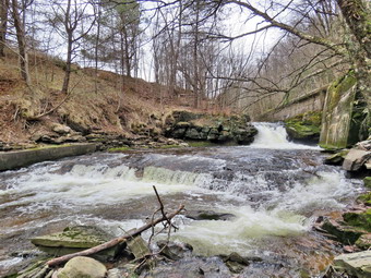
![]()
![]()
![]()
![]()
![]() On Saturday, April 6th, I wanted to get in a hike after several days of poor weather and ambulance calls! I wasn't sure there was another EMT available but I knew I had to get out for my own health. I decided to just go to Parksville and hike the rail trail even though it is under three miles out and back. I thought the stream might be high due to the recent rain which would make the falls interesting. By the time I started to get ready at 12:15 PM the temperature was right around 43 degrees on the back porch but a stiff breeze was blowing. I asked Cindy if she would like to go and she agreed. As we were getting dressed, Sheila alternated between us so she could keep an eye on both of us. I got dressed in my Mammut crew top with a short-sleeved baselayer. This combination is a little bit warmer and appropriate for the cooler weather. I wore a pair of Bauer First Ascent pants which are insulated against the cold and are slightly water repellant. I don't like the fit of these pants and have been looking for a replacement. I decided to put on my Keen Durand hiking boots which I ordered a half size larger than the previous pair. These shoes fit well out of the box but get much tighter when I add a decent insole. Without the third party insole, by feet hurt from the lack of support. I added a new pair of Xstance insoles in an effort to find the best support and cushioning for my feet. These insoles have shock absorbing gel pads, TPU arch support, and memory foam cushioning all wrapped in a breathable fabric. The insoles have been hyped by their manufacturer and they really do seem to deliver. I decided to take my Leki poles with external locks as the internal twist locks sometimes fail. I donned my Mammut hoody to block the breezy and keep me warm. It has pit zips that open all the way to the lower hem. I did put on a light hat and light knitted gloves. I also put on my OR Crocodile gaiters as I thought there would be a mixture of ice, water amd mud on the trail. I put our gear in the back of the car and Sheila in the back seat. We left Livingston Manor at 12:40 PM and drove out Old Route 17 toward Parksville. Just after Fox Mountain Road, I pulled into the parking area on the right side of the road. There was one car parked in the lot and another sitting in the middle of the lot with its engine running! I took my phone with me so that I could respond on an ambulance call if I had to. We started out on the trail at 1:00 PM under overcast skies with some sun amd a slight breeze blowing.
On Saturday, April 6th, I wanted to get in a hike after several days of poor weather and ambulance calls! I wasn't sure there was another EMT available but I knew I had to get out for my own health. I decided to just go to Parksville and hike the rail trail even though it is under three miles out and back. I thought the stream might be high due to the recent rain which would make the falls interesting. By the time I started to get ready at 12:15 PM the temperature was right around 43 degrees on the back porch but a stiff breeze was blowing. I asked Cindy if she would like to go and she agreed. As we were getting dressed, Sheila alternated between us so she could keep an eye on both of us. I got dressed in my Mammut crew top with a short-sleeved baselayer. This combination is a little bit warmer and appropriate for the cooler weather. I wore a pair of Bauer First Ascent pants which are insulated against the cold and are slightly water repellant. I don't like the fit of these pants and have been looking for a replacement. I decided to put on my Keen Durand hiking boots which I ordered a half size larger than the previous pair. These shoes fit well out of the box but get much tighter when I add a decent insole. Without the third party insole, by feet hurt from the lack of support. I added a new pair of Xstance insoles in an effort to find the best support and cushioning for my feet. These insoles have shock absorbing gel pads, TPU arch support, and memory foam cushioning all wrapped in a breathable fabric. The insoles have been hyped by their manufacturer and they really do seem to deliver. I decided to take my Leki poles with external locks as the internal twist locks sometimes fail. I donned my Mammut hoody to block the breezy and keep me warm. It has pit zips that open all the way to the lower hem. I did put on a light hat and light knitted gloves. I also put on my OR Crocodile gaiters as I thought there would be a mixture of ice, water amd mud on the trail. I put our gear in the back of the car and Sheila in the back seat. We left Livingston Manor at 12:40 PM and drove out Old Route 17 toward Parksville. Just after Fox Mountain Road, I pulled into the parking area on the right side of the road. There was one car parked in the lot and another sitting in the middle of the lot with its engine running! I took my phone with me so that I could respond on an ambulance call if I had to. We started out on the trail at 1:00 PM under overcast skies with some sun amd a slight breeze blowing.
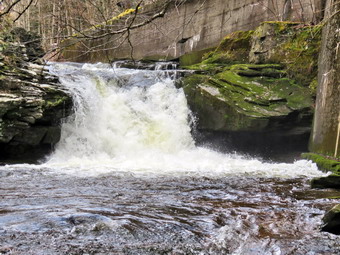 The first part of the trail was free of ice and snow but was damp and soft. Once we were on the trail and sheltered by the trees it was a little cooler and the trail was about as I expected with some snow, some water and some mud. I was surprised that there seemed to be less water and mud than during our last trip. In a short distance we looked up to see a male runner coming toward us. I took Sheila by her collar and we stepped off the trail as the runner went by. We continued our hike and began removing many small to medium sized branches off the trail. Once again we looked up to see a female runner coming toward us and once again I stepped off the trail with Sheila. The runner passed with a "Hello" and we continued on our way. Several times we walked in the water where the ground was firmer. As we walked, I considered my hiking plan. I had thought we would hike out and back on the rail trail but now the trail conditions had made me think we might hike a loop returning by the road. The rail trail runs parallel to the Little Beaverkill and the new section of State Route 17. It follows the route of the O&W railroad and is very flat. The water level in the stream was not quite as high as the last time we had hiked along the trail. We passed several benches placed for people to rest in warmer weather. I stopped at the area just before the wooden walkways and bridge but decided there was nothing different or more interesting than on many trips before. I was not surprised that the walkways were free of ice and snow but they were still slippery. There was some ice before and after the bridge but we wer able to walk around it. There was a new tree down across the trail which could be removed with hand tools. A little further along another tree was leaning over the trail. It was larger and at an angle that would make it harder to remove. We came to the tree I had trimmed to allow hikers to pass. I wanted to clear the trunk itself but decided it would need a chainsaw. We hopped over the trunk and immediately ran into two other smaller trunks across the trail. We continued on the trail heading toward the falls. There was one more small tree across the trail which we easily walked around. As we walked, we could hear an increase in the noise from the stream and I knew the falls was just ahead. When we got to the falls, I could see that the trail to the bottom of the falls was clear of any snow or ice. Sheila and I walked over to the path down to the streambed and began the descent. Cindy decided to sit on the picnic bench at the top and wait for us. At the bottom I put my pack down and took out my camera. I took shots downstream and directly in front of me where the water was very clear. I then turned my attention upstream to the falls. I took shots encompassing the entire scene and then several close-ups of the main falls and the rapids below it. I like the noise of the falls and the volume of water which exude power but also bring me peace. When I was finished, I packed up and walked back up the path to the trail where I met Cindy and Sheila. I took some more pictures of the falls from above and upstream. I packed up my camera and we continued on the trail.
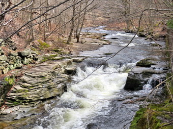 We met two women hiking toward us and we passed with a greeting. It was Saturday but the weather was not the best but it was nice to see some people. Soon we were nearing the Parksville end of the trail passing some rundown and dilapidated buildings which should be removed. Several of the buildings showed that work had been done on them. On the Parksville end of the trail we found the small garden and a very informative sign. We also had to endure the pack of barking dogs that always greets us. The owner came out but as usual the dogs ignored him! The sign listed the businesses and hotels that existed in Parksville during its heyday. The Young's Gap Hotel had room for 600 guests! The sign also explained the role of the railroad in the dairy industry which was a thriving one in all of Sullivan County. After a brief pause, we walked the rest of the rail trail to the Main Street where we turned left. There are many interesting buildings along a short stretch of street but most are unoccupied and crumbling. There are a few residences and one small home had a Tesla in the driveway charging with no garage in sight. When we got to the access road, we passed the Dead End Caf� which brought back memories of when it was a thriving business. An OPEN sign still hung in the window. We turned left and walked on a gravel path that paralleled the road. We passed what was once the synagogue but is now the Parksville Arts Center with a Star of David on the front! The path continued to a parking area and then exited the other side. We continued on this path passing the building which once held Memories where I had bought several items at auction. The path ended in another parking area so we had to walk the shoulder of the road to get back to our car. There was almost no traffic on the road and the shoulder was wide and the drivers considerate. We arrived back at the car at 2:25 PM after hiking 2.8 miles in 1 and 25 minutes. My phone had not sounded meaning there had been no ambulance calls.
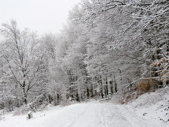
![]()
![]()
![]()
![]()
![]() On Thursday, April 4th I was awakened by an early morning ambulance call. When I went to sleep, it was still raining but when I woke up there was snow on the ground! I had to clear 3 inches of snow off my car and make my way down the drive way to respond. When we arrived on the scene, there was no patient and we teetered to base. By 10:00 AM things had calmed down and I decided to go across the street and hike on Round top since I could still respond on calls. I wanted to take some pictures of the snow that had fallen. I began to get ready with the temperature at 35 degrees on the back porch amd light snow still falling. I knew that was the temperature climbed the snow would start falling off the trees. This makes for poor photographic conditions and a shower of "snow bombs" dropping on the trail while hiking. I decided to take my pack so that I could carry my camera and because it adds weight making the hike more challenging. As we began to get ready, Sheila was running around barking at my every move. Sheila often examines and sniffs my clothing to make sure I am serious about hiking. I decided to wear my Mammut long-sleeved crew shirt but without a baselayer. This might mean I would be a little cool at the beginning of the hikes but it also meant I would not be dripping in sweat climbing the hills. I wore a pair of Bauer First Ascent pants which are insulated against the cold and are slightly water repellant. I don't like the fit of these pants and have been looking for a replacement. I decided to put on my old Salomon b52 winter boots which I have worn for many seasons. I noticed that they were dry and needed a coat of waterproofing. I wore my OR Crocodile gaiters to keep the snow out of my shoes. I decided to take my Leki poles with external locks as the internal twist locks sometimes fail. I did decide to wear my Mammut hoody to block the breeze and keep me warm. It has pit zips that open all the way to the lower hem. I did put on a fleecy hat and a pair of light gloves. I brought along my phone in case there were any calls. At 11:35 AM we walked out the door to start the hike. I grabbed Sheila's leash from my car and put it on her as we walked up the driveway which was not shoveled or plowed. I aimed to hike for about a little over an hour and complete two figure 8's. Sheila was happy to get out as we headed down the driveway and across the street. We crossed the street and walked to the parking lot next to the Presbyterian Church. The parking lot was partly occupied by a dump truck, trailer and back hoe. I wondered why the equipment was parked there. We walked to the back of the church and began the ascent of the steepest hill behind the church. I released Sheila from her leash so I could use my poles effectively. The hill is short but gets the circulation pumping and is the steepest and longest climb on the "trail." The hill was completely covered in untouched snow. I was sad that no kids had been out to sled on the hill and no one else had decided to take a walk. I did not have to stop once on the way to the top of the hill and the trip went quickly. At the top we paused for a minute so I could look around at the hills that surround the hamlet of Livingston Manor. I took out my camera and took shots of the snow both near and far. The snow that was still falling made it difficult to get good pictures. The snow was wet and was beginning to wet my pack and jacket.
On Thursday, April 4th I was awakened by an early morning ambulance call. When I went to sleep, it was still raining but when I woke up there was snow on the ground! I had to clear 3 inches of snow off my car and make my way down the drive way to respond. When we arrived on the scene, there was no patient and we teetered to base. By 10:00 AM things had calmed down and I decided to go across the street and hike on Round top since I could still respond on calls. I wanted to take some pictures of the snow that had fallen. I began to get ready with the temperature at 35 degrees on the back porch amd light snow still falling. I knew that was the temperature climbed the snow would start falling off the trees. This makes for poor photographic conditions and a shower of "snow bombs" dropping on the trail while hiking. I decided to take my pack so that I could carry my camera and because it adds weight making the hike more challenging. As we began to get ready, Sheila was running around barking at my every move. Sheila often examines and sniffs my clothing to make sure I am serious about hiking. I decided to wear my Mammut long-sleeved crew shirt but without a baselayer. This might mean I would be a little cool at the beginning of the hikes but it also meant I would not be dripping in sweat climbing the hills. I wore a pair of Bauer First Ascent pants which are insulated against the cold and are slightly water repellant. I don't like the fit of these pants and have been looking for a replacement. I decided to put on my old Salomon b52 winter boots which I have worn for many seasons. I noticed that they were dry and needed a coat of waterproofing. I wore my OR Crocodile gaiters to keep the snow out of my shoes. I decided to take my Leki poles with external locks as the internal twist locks sometimes fail. I did decide to wear my Mammut hoody to block the breeze and keep me warm. It has pit zips that open all the way to the lower hem. I did put on a fleecy hat and a pair of light gloves. I brought along my phone in case there were any calls. At 11:35 AM we walked out the door to start the hike. I grabbed Sheila's leash from my car and put it on her as we walked up the driveway which was not shoveled or plowed. I aimed to hike for about a little over an hour and complete two figure 8's. Sheila was happy to get out as we headed down the driveway and across the street. We crossed the street and walked to the parking lot next to the Presbyterian Church. The parking lot was partly occupied by a dump truck, trailer and back hoe. I wondered why the equipment was parked there. We walked to the back of the church and began the ascent of the steepest hill behind the church. I released Sheila from her leash so I could use my poles effectively. The hill is short but gets the circulation pumping and is the steepest and longest climb on the "trail." The hill was completely covered in untouched snow. I was sad that no kids had been out to sled on the hill and no one else had decided to take a walk. I did not have to stop once on the way to the top of the hill and the trip went quickly. At the top we paused for a minute so I could look around at the hills that surround the hamlet of Livingston Manor. I took out my camera and took shots of the snow both near and far. The snow that was still falling made it difficult to get good pictures. The snow was wet and was beginning to wet my pack and jacket.
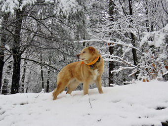 We entered the woods at the trailhead and continued on to the first junction. Sheila and I both seemed to have the same idea as I wanted to go straight up to the lookout and Sheila chose that path. Climbing the hill seemed easy but I did slip a few times. I noticed that there were boot prints and paw prints in the snow and I was happy that someone had enjoyed the walk with their dog. The snow had already started falling from the trees. When we reached the top of the hill, we detoured to the left and walked out to the lower lookout which was covered in snow over some ice below. I got out my camera and took pictures of the lookout and the shots of the school and the town below. I directed Sheila to go to the upper lookout but she was being very stubborn. Eventually she went up to the ledge and posed for some pictures. I packed up my camera amd walked back out to the main yellow trail where we turned left to walk to the upper lookout. Where the trail turned right we followed it uphill through a winter wonderland. All the trees were covered in snow and I love walking in snow that no one else as touched. The boot and paw prints had only gone as far as the lookout! We passed the sitting rock which was piled high with the white stuff. We continued uphill to the junction with the blue trail. We turned right to follow the yellow trail along the base of Round Top. I stopped to take some picture of the snow hanging on the bushes. As we walked the old woods road, I found several bushes and small trees hanging into the trail. I used my poles to knock the snow off and many of the branches rebounded.
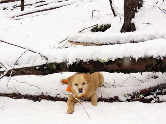 As we continued to the next junction with the blue trail, we came to a medium sized birch tree that had fallen across the trail. I took a few shots and it was clear the tree could be removed, with some effort, using hand tools. At the junction with the blue trail, we turned right to climb the trail toward the summit. We passed by the white crossover trail and continued over the summit which was also beautiful with trees encased in snow. We started down the other side slipping a little and bypassing the white trail. We did turn left on the switchback in the blue trail. We followed it out into the woods and back again to the blue trail farther down the hill. We turned left on the main blue trail and walked downhill until we were back at the junction with the yellow trail. We turned left and again walked along the yellow trail to the next junction with the blue trail. This time we turned right and started to walk down the trail to the woods road. Sheila and I started down the woods road at a quick pace but came to another blowdown lying on the trail. This one was larger in diameter than the previous one but had fewer branches. This one could also be removed with hand tools. When we reached the first trail junction, I debated not doing anither figure 8 but knew I would not take any pictures so the walk would be quicker. We turned around and started back up the woods road we had just descended. We set a faster pace up the woods road and turned left to stay on the yellow trail as the woods road ended. At the junction with the blue trail we turned left to stay on the yellow trail along the base of Round Top. We walked under the fallen birch tree and passed by some bushes that were still hanging into the trail. At the second junction with the blue trail, we turned right and began to ascend the hill. We turned right where the switchback led us out into the forest and then back to the main blue trail. We turned right and headed for the summit passing by the white crossover trail. We walked over the summit and down the other side again passing the white trail. At the base of the hill we turned right on the yellow trail and again walked along the base of Round Top to the second junction with the blue trail. This time we turned left and headed down the yellow trail toward the lookout. At the viewpoint where the yellow trail turned left we followed it and walked down the hill to the very first trail junction. We continued to walk straightahead out to the trailhead where we turned right. I put Shiela on her leash and we walked downhill to the road behind the church. We walked out through the parking lot and across the street to our driveway. We were back home at12:55 PM after hiking almost 3 miles in 1 hour and 20 minutes.
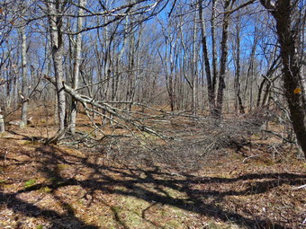
![]()
![]()
![]()
![]()
![]() On Saturday, March 30th I wanted to get out for a hike after a week of poor weather and ambulance calls. My son-in-law Brad was around for a few days and I thought we might go to Frick Pond and cut two blowdowns that had been reported. We responded to an early morning ambulance call and returned home to get some breakfast. We I started to get ready at 11:00 AM with the temperature at 43 degrees and a stiff breeze blowing. The skies were blue with some nice white clouds. I put on my Mammut long-sleeved crew top with a light long-sleeved baselayer as I knew it would be cooler at the trailhead. This combination is a little bit warmer and appropriate for the cooler weather. I wore my Railriders hiking pants which I thought would be warm enough despite the low temperature. They are expensive but last along time and have features like deep pockets and a generous cut which I really like. The pants have Velcro closures at the ankles. I decided to put on my Keen Durand hiking boots which I ordered a half size larger than the previous pair. These shoes fit well out of the box but get much tighter when I add a decent insole. Without the third party insole, by feet hurt from the lack of support. I added a new pair of Xstance insoles in an effort to find the best support and cushioning for my feet. These insoles have shock absorbing gel pads, TPU arch support, and memory foam cushioning all wrapped in a breathable fabric. The insoles have been hyped by their manufacturer and they really do seem to deliver. I decided to take my Leki poles with external locks as the internal twist locks sometimes fail. I donned my Mammut hoody to block the breezy and keep me warm. It has pit zips that open all the way to the lower hem. I did put on a fleecy hat and took a pair of light knitted gloves. I also put on my OR Crocodile gaiters as I thought there would be some water and mud on the trail. I put my Silky Sugowaza Sugowaza saw and Silky KatanaBoy 500 saw in my pack. The Sugowaza is a fixed blade in a scabbard and is great for branches and smaller trunks. The KatanaBoy has very large teeth and a lot of them and folds. I also brought my Fiskars ax which I knew Brad could carry. I put our gear in the back and Sheila in the backseat and headed out the DeBruce Road at 1:25 PM. After 6 miles, at Mongaup Pond Road, I turned left and continued to follow the road bearing left onto Beech Mountain Road at the fork. There was one car parked in the larger lot as I pulled into the smaller parking area.
On Saturday, March 30th I wanted to get out for a hike after a week of poor weather and ambulance calls. My son-in-law Brad was around for a few days and I thought we might go to Frick Pond and cut two blowdowns that had been reported. We responded to an early morning ambulance call and returned home to get some breakfast. We I started to get ready at 11:00 AM with the temperature at 43 degrees and a stiff breeze blowing. The skies were blue with some nice white clouds. I put on my Mammut long-sleeved crew top with a light long-sleeved baselayer as I knew it would be cooler at the trailhead. This combination is a little bit warmer and appropriate for the cooler weather. I wore my Railriders hiking pants which I thought would be warm enough despite the low temperature. They are expensive but last along time and have features like deep pockets and a generous cut which I really like. The pants have Velcro closures at the ankles. I decided to put on my Keen Durand hiking boots which I ordered a half size larger than the previous pair. These shoes fit well out of the box but get much tighter when I add a decent insole. Without the third party insole, by feet hurt from the lack of support. I added a new pair of Xstance insoles in an effort to find the best support and cushioning for my feet. These insoles have shock absorbing gel pads, TPU arch support, and memory foam cushioning all wrapped in a breathable fabric. The insoles have been hyped by their manufacturer and they really do seem to deliver. I decided to take my Leki poles with external locks as the internal twist locks sometimes fail. I donned my Mammut hoody to block the breezy and keep me warm. It has pit zips that open all the way to the lower hem. I did put on a fleecy hat and took a pair of light knitted gloves. I also put on my OR Crocodile gaiters as I thought there would be some water and mud on the trail. I put my Silky Sugowaza Sugowaza saw and Silky KatanaBoy 500 saw in my pack. The Sugowaza is a fixed blade in a scabbard and is great for branches and smaller trunks. The KatanaBoy has very large teeth and a lot of them and folds. I also brought my Fiskars ax which I knew Brad could carry. I put our gear in the back and Sheila in the backseat and headed out the DeBruce Road at 1:25 PM. After 6 miles, at Mongaup Pond Road, I turned left and continued to follow the road bearing left onto Beech Mountain Road at the fork. There was one car parked in the larger lot as I pulled into the smaller parking area.
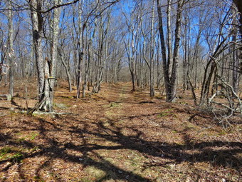 We got ready to hike and started out at 11:35 AM. We walked out the woods road to the Quick Lake Trail at the trail register. The woods road was damp and muddy in spots. Looking ahead we could see that the trail from the register was very wet and muddy in many places. We could also see a couple with a spirited dog on a leash trying to pick their way along the muddy trail. I put Sheila on her leash and we walked at a pace to get by the other hikers and their dog. As we passed, we greeted each other as their dog barked its head off. Brad and I kept up the pace working around or through the mud and water. When we got to Gravestone junction we headed right on the Loggers Loop to find the first blowdown. This trail was a little less muddy and there were no larger pools of water. Within a few hundred feet we came to the primitive campsites on the left. There was a large branch from an even larger tree that had fallen across the trail effectively blocking it. Hikers had been walking around it but I hoped we could remove all of it from the trail. I put my pack down and took out the camera to take some "before" pictures of the mess before us. We walked up to the blowdown and started to form a plan. We first hauled away all the loose branches and when we were done it already looked better. I used the Sugowaza to cut some of the smaller branches to expose the rest of the large branches. Brad and I dragged what I had cut. What remained were the main branch and some slightly smaller ones. As we were deciding what to do next, the couple with their dog appeared. It seemed they wren't sure what to do but the decided too stay on the trail and walk passed us. At least they walked off the trail and did not walk through our workspace or under anything we were cutting. Most people usually say "Thank you when they see people clearing the trail for them but these two were silent.
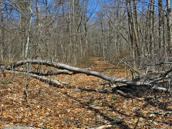 We decided to use the KatanaBoy to cut one of the higher branches that was not supporting anything else. Brad used the bigger saw and quickly cut away the branch which I dragged away. We decided to cut the largest branch toward the top and Brad made a cut that was done in seconds. Brad made another cut of the larger diameter main branch. We had to be careful as I had not brought along any wedges to free the saws if they started to bind. I usually make a cut from the top down and then remove the saw and make a cut up from the bottom. Brad's approached was to cut so fast that the saw ahd no chance to bind! As he finished the cut the branch rotated but we were able to avoid getting hit. The rest of the main branch collapsed against the trunk of the trail. We dragged the section that was Brad had cut away. At his point another hiker approached and walked around our work without a word of thanks or greeting! I guess people don't understand that the trails are maintained by volunteers for the use of others! That left a few smaller branches to cut and remove. When we were done, we put away the tools and I took a few "after" pictures of the now clear trail. It appeared that it had never been blocked! We walked along the trail clearing a few branches and small trunks here and there. We hot the highest point on that section of trail and started down a long hill to Times Square. This part of the trail was muddy in may posts with some standing water. As we approached Times Square, we could Se the couple and their dog at the trail junction. They hadn't gotten very far and seemed to be wondering where they should go next. I put Sheila on her leash again as the couple tried to get their dog off the trail. The dog kpet barking as loudly as possible as we turned right and headed up the Big Rock Trail. I released Sheila from her leash which allowed me to more effectively use my poles as we climbed up the hill.
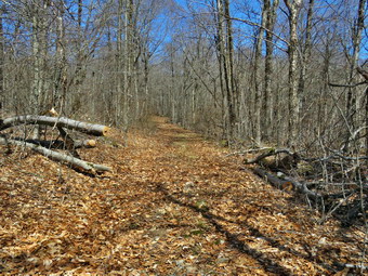 We started up the Big Rock Trail and the initial part slowed me down some. After I adjusted my breathing, the climb was easier. We made it to the top of the first climb where the trail faltered out a little. Up ahead we could see one small trunk across the trail followed by a much larger trunk with several branches. We stepped over the small trunk and walked to the larger blowdown. I took some "before" shots of the blowdown before we started to work. We cleared out some of the loose banches and cut a few small trees that were in the way. I used the small saw to cut the top out of the tree leaving only the larger trunks. The largest trunk was well supported on the butt end with the part over the trail just hanging in midair. Brad used the KatanaBoy to cut a section off the top of trunk. All I contributed was some downward pressure. The section quickly dropped to the ground and just as quickly Brad had it off to the side of the trail. Brad then picked a spot further up the trunk which was 8 or 10 inches in diameter and applied the saw. This cut took a little longer but not much. That section dropped to the ground and Brad maneuvered it off the trail. There was still a piece of another trunk sticking out into the trail so Brad cut that piece off. This time flipped the piece off the trail and we were done. I took some quick shots of the trail we had just cleaned. We walked down to the trail to the small trunk and I took some pictures. I grabbed the ax and cut the top off the trail. Brad was able to picot what I had cut off the trail. We were done so I snapped a few "after" pictures. I packed everything up and we started back down the Big Rock Trail to Times Square. As we descended the last part of the hill, we could see a family was occupying most of Times Square. I put Sheila on her leash as I intended to walk across the trail junction and stay on the Big Rock Trail. As we passed be the family, we exchanged greetings. The trail was wet in spots and muddy in others. We crossed the two bridges over the inlet streams and I pointed out to Brad how high the water was. We continued through the spruce tunnel which was completely bare. The last time I had been under these trees there was a layer of ice with more ice falling from the trees! We walked over the boardwalks which were clear of snow and ice. As we continued on the trail we ran into section of mud just before the junction with the Quick Lake Trail. We turned left on the Quick Lake Trail and headed for the bridge at the outlet end of Frick Pond. The trail was damp and muddy but in better shape than on my last trip. We walked across the bridge and I decided not to stop for pictures. Next it was up the hill for a quick walk to Gravestone Junction to complete the loop. We headed back to the car on the Quick Lake Trail which seemed just a bit drier than on our trip out two hours earlier. As we walked back to the car on the woods road, I could see that there were now four cars parked in the smaller lot and four more in the large area. We had met more people than I had since the previous fall. We were back at 1:35 PM. Walking about 2.5 miles and working on two large blowdowns had taken about 2 hours. I like to think I can do as much work with hand saws and axes as with a chain saw. Everything can be cleared with hand tools but it usually takes more time.
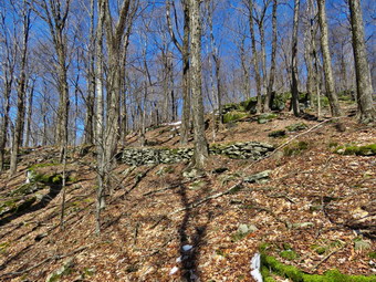
![]()
![]()
![]()
![]()
![]() On Monday, March 25th, I wanted to get out for a longer hike to continue my efforts to hike more frequently I had an overnight ambulance call and slept in until 8:30 AM. I knew that I was the only EMT available to answer calls but I also needed to take some time for myself and Sheila. Rather than travel too far I decided to go to Frick Pond and hike the Flynn Trail where I could hike some uphill miles. This would give me some choices of how far I wanted to hike and the route I would take. I also wanted to see if there were any trees that needed trimming to make hiking easier. I asked Cindy if she wanted to go and was surprised when she said "Yes" as she generally does not like hills. I wanted to hike to the lookout by the cabin on the shoulder of Beech Mountain but knew Cindy would not like that much uphill hiking. As I started to get ready at 1:15 PM, the temperature on the back porch was 48 degrees with sunny skies! This was a far cry from the rain and cold weather over the weekend. I put on my Mammut long-sleeved crew top with a light long-sleeved baselayer as I knew it would be cooler at the trailhead. This combination is a little bit warmer and appropriate for the cooler weather. I wore my Railriders hiking pants which I thought would be warm enough despite the low temperature. They are expensive but last along time and have features like deep pockets and a generous cut which I really like. The pants have Velcro closures at the ankles. I decided to put on my Keen Durand hiking boots which I ordered a half size larger than the previous pair. These shoes fit well out of the box but get much tighter when I add a decent insole. Without the third party insole, by feet hurt from the lack of support. I added a new pair of Xstance insoles in an effort to find the best support and cushioning for my feet. These insoles have shock absorbing gel pads, TPU arch support, and memory foam cushioning all wrapped in a breathable fabric. The insoles have been hyped by their manufacturer and they really do seem to deliver. I decided to take my Leki poles with external locks as the internal twist locks sometimes fail. I donned my Mammut hoody to block the breezy and keep me warm. It has pit zips that open all the way to the lower hem. I did put on a fleecy hat and took a pair of light knitted gloves. I also put on my OR Crocodile gaiters as I thought there would be some water and mud on the trail. I put our gear in the back and Sheila in the backseat and headed out the DeBruce Road at 1:25 PM. After 6 miles, at Mongaup Pond Road, I turned left and continued to follow the road bearing left onto Beech Mountain Road at the fork. When we arrived in the parking area there was one car parked in the larger lot. I pulled into the smaller lot with Sheila acting as if she hadn't hiked in a month as she ran around and headed for the trail. The temperature was 46 degrees and the skies were blue with white clouds. We crossed the road and began our hike at 1:45 PM.
On Monday, March 25th, I wanted to get out for a longer hike to continue my efforts to hike more frequently I had an overnight ambulance call and slept in until 8:30 AM. I knew that I was the only EMT available to answer calls but I also needed to take some time for myself and Sheila. Rather than travel too far I decided to go to Frick Pond and hike the Flynn Trail where I could hike some uphill miles. This would give me some choices of how far I wanted to hike and the route I would take. I also wanted to see if there were any trees that needed trimming to make hiking easier. I asked Cindy if she wanted to go and was surprised when she said "Yes" as she generally does not like hills. I wanted to hike to the lookout by the cabin on the shoulder of Beech Mountain but knew Cindy would not like that much uphill hiking. As I started to get ready at 1:15 PM, the temperature on the back porch was 48 degrees with sunny skies! This was a far cry from the rain and cold weather over the weekend. I put on my Mammut long-sleeved crew top with a light long-sleeved baselayer as I knew it would be cooler at the trailhead. This combination is a little bit warmer and appropriate for the cooler weather. I wore my Railriders hiking pants which I thought would be warm enough despite the low temperature. They are expensive but last along time and have features like deep pockets and a generous cut which I really like. The pants have Velcro closures at the ankles. I decided to put on my Keen Durand hiking boots which I ordered a half size larger than the previous pair. These shoes fit well out of the box but get much tighter when I add a decent insole. Without the third party insole, by feet hurt from the lack of support. I added a new pair of Xstance insoles in an effort to find the best support and cushioning for my feet. These insoles have shock absorbing gel pads, TPU arch support, and memory foam cushioning all wrapped in a breathable fabric. The insoles have been hyped by their manufacturer and they really do seem to deliver. I decided to take my Leki poles with external locks as the internal twist locks sometimes fail. I donned my Mammut hoody to block the breezy and keep me warm. It has pit zips that open all the way to the lower hem. I did put on a fleecy hat and took a pair of light knitted gloves. I also put on my OR Crocodile gaiters as I thought there would be some water and mud on the trail. I put our gear in the back and Sheila in the backseat and headed out the DeBruce Road at 1:25 PM. After 6 miles, at Mongaup Pond Road, I turned left and continued to follow the road bearing left onto Beech Mountain Road at the fork. When we arrived in the parking area there was one car parked in the larger lot. I pulled into the smaller lot with Sheila acting as if she hadn't hiked in a month as she ran around and headed for the trail. The temperature was 46 degrees and the skies were blue with white clouds. We crossed the road and began our hike at 1:45 PM.
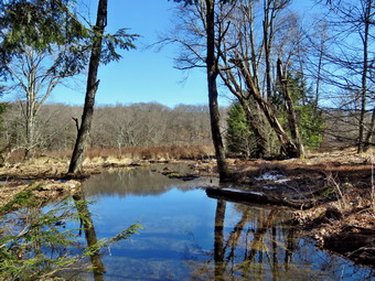 The Flynn Trail is sited along what used to be Beech Mountain Road which was the access for the Beech Mountain Boy Scout Camp. We walked the trail through the woods which was mostly damp with a little mud but no snow. We passed by several trees I had cut and removed from the trail. Some were cut with the help of local Ranger Eric Stratton. There was one new tree that had fallen across the trail which would require tools to remove. We continued on the Flynn Trail and turned right on the woods road and continued to set a good pace up the hill. The trail gains a little over 600 feet in 1.7 miles to the highest point at the junction with the Big Rock Trail. It was obvious that a large volume of water had run down the trail during the weekend rain storms as their was a trench with many displaced ;eaves. We passed the hemlock that used to form a tunnel but was cleared by the DEC. The trail continued to be free of snow although we could see some in the woods especially in the shadows. I began to find some small branches on the trail which I removed. I also found some larger branches and trunks that had come down in the high winds of the recent storms. At one point I looked up to see couple hiking toward us. I escorted Sheila if the trail to allow the hikers to pass. They said "Hello" and I asked what route they had taken. They did not know the names of the trails but indicated they had come up the Big Rock Trail from Frick Pond. They told us there were no blowdowns and the trail was easy to walk. As we hiked Cindy noticed a road to the right of the trail and wondered if it led to the clearing further up the trail. I asked if whe would like to hike it and she agreed. I knew the road led up over the ledges that we usually pass by on the Flynn Trail and then came back down to the Flynn Trail. The road starts out clear of brush and blowdowns but quickly becomes obscured. We worked out way around and over the brush and blowdowns until we were near the highest point on the trail. I saw the stonework that supported the road which indicated it was not simply a wagon track through the forest but a constructed road. I pointed this out to Cindy and then walked off the road to take some pictures. When I was done, I walked back to the road and we continue up to the highest point on the road. I dropped my pack and took some sots of the ledges and rocks further up the ridge. I then walked out onto the large rock that forms a ledge that we see when hiking up the Flynn Trail. I took some picture of Sheila and some down to the Flynn Trail below. I finished up and packed away my camera and we walked the short downhill to the Flynn rail. We turned right and started up the trail. When we came to the area near the clearing to the right of the trail, we noticed the amount if snow had increased off the trail. I asked Cindy if she would like to walk up to the clearing but she declined. I noticed that I was very relaxed and decided I needed to get out more as the other things that I do can be stressful. Further up the trail, we did run across a few small trees across the trails and one very large one. I worked to remove some of the branches around the large blowdown to clear a path for hikers. We kept walking uphill and we were soon at the junction with the Big Rock Trail. This junction was clear of snow but the forest floor off the trail was covered in snow in all four directions. Cindy noticed that the trail sign had been damaged and that it looked purposeful! I took some pictures of the sign to send to the forester. We turned left to walk down the Big Rock Trail where the layer of snow off trail continued for some time. The hike down the trail went well and more quickly than I expected. It was definitely easier than the uphill hike. This trail can be tricky as there are several levels that make it seem like the bottom of the hill. It definitely helped to have someone to talk to while hiking. We did run into a large blowdown with a good-sized trunk and many branches. The blowdown almost blocked the trail and would require tools to remove it. As we came to the bottom of the descent, the snow disappeared.
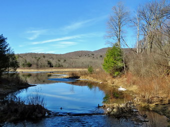 We were soon at Times Square and I thought about turning right to hike up and around the Logger's Loop to add some distance to our hike. Cindy did not like this idea and she turned left to hike the uphill Loggers Loop back to Gravestone Junction. She thought this would be easier in her hip! Sheila and I continued our hike by walking straight across Times Square to stay on the Big Rock Trail. The Big Rock Trail around the back of Frick Pond can be very wet, and this day was no exception. There was water, mud, and frozen water and mud in most place along the trail. We passed the very large blowdown which Ranger Stratton and I had cleared. As we headed for the two small bridges on the trail, we ran into a some ice and snow which made the trail very slippery for me. Sheila was having no problem with the ice and snow. We came to the two small bridges over the inlets to the pond and I decided to stop to take pictures. The water under the first bridge was backed up from the wetlands and was higher than it had been for some time. At first I attributed the height of the water to the recent rains but looking downstream I saw the outline of some beavers dam. I took pictures from several angles and with varying zooms. I took a picture of the second bridge which was completely covered in snow. I also took some shots upstream. The area under the second bridge had a stream fowling but the volume was lower. When we got to the area that was covered by tall evergreens, we again ran into a lot of ice on the trail. It was clear that the trees had been covered in ice which had fallen onto the trail. The wooden boardwalks had some ice and snow and continue to show wear with many boards loose and other beginning to rot. Much of the boardwalk now "floats" in midair as the supports are rotting. I did not stop to take pictures and continued the hike.
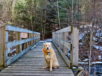 The rest of the trail was free from snow to the trail junction but the trail was very muddy in many places. At the next trail junction we turned left on the Quick Lake Trail to head for the bridge across the outlet of Frick Pond. A glance to the right and I could see the trail was open and free of blowdowns. Cindy and I had cleared some blowdowns on the last trip and no more had fallen in this area. As we walked along the west side of Frick Pond to the bridge across the outlet of the pond, there was a some snow and ice as the trail is shaded by trees and bushes. The small stream that exist in this area were swollen and running with a high volume of water. We crossed the bridge and I put down my pack and got out the camera. I took shots of the pond and of Beech Mountain from different angles. I also took some pictures of Sheila on the bridge. When I was done, I packed up the camera and started up the hill toward Gravestone Junction. The hill was covered in ice forcing me to the sides of the trail. At the top, we continued along the trail to Gravestone Junction. The junction is named for the memorial near the junction for a tragedy involving the Lobdells. The father of this family was the caretaker for the Frick popery and the family lived in a cabin along what is now the Quick Lake Trail. One night the cabin caught fire. The parents were able to get out but their two children were trapped inside and died in the flames. I wondered where Cindy might be but assumed she had made it back to the car while I was taking a slightly longer path. I heard a dog barking and a voice yelling at the dog to come back. The dog did not pay attention and soon came into view. When he saw me, he stopped and then turned around and went back to his master. I did not bring a leash but attached one of my hiking poles to her collar. We walked out the trail from Gravestone Junction and continued on the Quick Lake Trail passing the Lobdell memorial marker. The trail back to the register was alternately covered in watre and ice sometimes mixed with mud. We passed the trail register heading toward the parking area. We continued straight ahead to follow the woods road out to the car in the small lot. Sheila saw Cindy by the car but stayed with me as I directed until I let her go. We arrived at the car at 4:15 PM having hiked over 4 miles in 2 hour and 30 minutes with an elevation gain of almost 800 feet. The temperature was 48 degrees at the car. There were now two different cars parked in the larger lot. I checked my phone and found there had been no ambulance lass! I backed out go the lot and headed home feeling a little tired but very relaxed. As we passed Mongaup Pond Road, I thought about stopping to go to Mongaup Falls but kept driving instead!
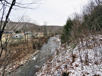
![]()
![]()
![]()
![]()
![]() On Friday, March 22nd, I wanted to get in a hike before the winter weather watch took effect for the weekend! This would also be the first hike of the spring although the weather did not reflect that. After an early morning ambulance call, I decided to take some time to hike on a cool but sunny day. It was 10:15 AM when I decided to just go to Parksville and hike the rail trail even though it is under three miles out and back. As I started to get ready the temperature was 25 degrees. The skies that had been sunny were now overcast. I asked Cindy if she wanted to go and she surprised me by saying "Yes". I got dressed in my Mammut crew top with a long-sleeved baselayer. This combination is a little warmer than what I sometimes wear but I thougth that it would be colder in the shade of the trees on the rail trail. I wore my Railriders hiking pants which I thought would be warm enough despite the low temperature. They are expensive but last along time and have features like deep pockets and a generous cut which I really like. The pants have Velcro closures at the ankles. I decided to put on my Keen Durand hiking boots which I ordered a half size larger than the previous pair. These shoes fit well out of the box but get much tighter when I add a decent insole. Without the third party insole, by feet hurt from the lack of support. I added a new pair of Xstance insoles in an effort to find the best support and cushioning for my feet. These insoles have shock absorbing gel pads, TPU arch support, and memory foam cushioning all wrapped in a breathable fabric. The insoles have been hyped by their manufacturer and they really do seem to deliver. I took a pair of Leki poles with external locks as the internal twist locks sometimes fail. I wore my Mammut hoody to block the breezy and keep me warm. It has pit zips that open all the way to the lower hem. I put in a light fleece hat and brought along a pair of light gloves. I also put on my OR Crocodile gaiters as I thought there would be a mixture of snow, ice, and mud on the trail. I put our gear in the back of the car and Sheila in the back seat. We left Livingston Manor at 10:40 AM PM and drove out Old Route 17 toward Parksville. Just after Fox Mountain Road, I pulled into the parking area on the right side of the road. There were no cars parked in the lot as we were getting ready to hike. I left my phone in the car so that I could enjoy the hike. We started out on the trail at 11:00 AM with very little sun under overcast skies.
On Friday, March 22nd, I wanted to get in a hike before the winter weather watch took effect for the weekend! This would also be the first hike of the spring although the weather did not reflect that. After an early morning ambulance call, I decided to take some time to hike on a cool but sunny day. It was 10:15 AM when I decided to just go to Parksville and hike the rail trail even though it is under three miles out and back. As I started to get ready the temperature was 25 degrees. The skies that had been sunny were now overcast. I asked Cindy if she wanted to go and she surprised me by saying "Yes". I got dressed in my Mammut crew top with a long-sleeved baselayer. This combination is a little warmer than what I sometimes wear but I thougth that it would be colder in the shade of the trees on the rail trail. I wore my Railriders hiking pants which I thought would be warm enough despite the low temperature. They are expensive but last along time and have features like deep pockets and a generous cut which I really like. The pants have Velcro closures at the ankles. I decided to put on my Keen Durand hiking boots which I ordered a half size larger than the previous pair. These shoes fit well out of the box but get much tighter when I add a decent insole. Without the third party insole, by feet hurt from the lack of support. I added a new pair of Xstance insoles in an effort to find the best support and cushioning for my feet. These insoles have shock absorbing gel pads, TPU arch support, and memory foam cushioning all wrapped in a breathable fabric. The insoles have been hyped by their manufacturer and they really do seem to deliver. I took a pair of Leki poles with external locks as the internal twist locks sometimes fail. I wore my Mammut hoody to block the breezy and keep me warm. It has pit zips that open all the way to the lower hem. I put in a light fleece hat and brought along a pair of light gloves. I also put on my OR Crocodile gaiters as I thought there would be a mixture of snow, ice, and mud on the trail. I put our gear in the back of the car and Sheila in the back seat. We left Livingston Manor at 10:40 AM PM and drove out Old Route 17 toward Parksville. Just after Fox Mountain Road, I pulled into the parking area on the right side of the road. There were no cars parked in the lot as we were getting ready to hike. I left my phone in the car so that I could enjoy the hike. We started out on the trail at 11:00 AM with very little sun under overcast skies.
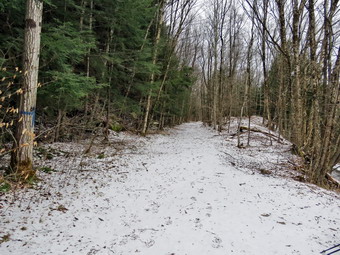 The first part of the trail was completely bare and frozen making it dry. There was some snow on the sides of the trail. We looked up and a man was walking toward us with a small dog which was barking its head off. I put Sheila on her leash and we walked by. Sheila eyed the other dog as if she was wondering why there was so much commotion. Once we were on the trail and sheltered by the trees it was slightly cooler and there was more snow and ice on the trail. There was a little water in a few places but most of the trail was frozen. We were able to set a fast pace as we did not have to work our way around mud and ice. The rail trail runs parallel to the Little Beaverkill and the new section of State Route 17. It follows the route of the O&W railroad and is very flat. The water level in the stream was high and there was some ice in the stream in several places. We passed several benches placed for people to rest in warmer weather. I stopped at the area just before the wooden walkways and the bridge to take some pictures down to the stream. The stream looked very cold and was made even colder by the overcast skies. I also took pictures of the trail which was covered in snow. The trail and walkways were covered in snow in both directions. As we walked over the walkways, we had to make sure of our footing as it was very slippery. We came to the area where a mudslide had brought down earth and a number of trees onto the trail. There was also a covering of ice in this area which was very slippery. We hopped over the trunk and carefully walked along the edge of the ice. Once we were off the ice, we picked up the pace again. We continued on the trail heading toward the falls. As we walked, I could hear an increase in the noise from the stream and I knew the falls were just ahead. When we got to the falls, I debated whether or not I would descend the path to the streambed. I decided that I had enough pictures from the base of the falls and would take some shots from the trail.
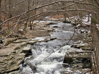 I like the noise of the falls and the volume of water which I find peaceful. I took some more pictures of the falls from above. I also took shots upstream where there was a nice contrast between the stream and the leaves on the ground. I packed up my camera and we continued on the trail toward Parksville. Soon we were nearing the Parksville end of the trail passing many places where there were signs work was being done to clean up the area. There was a large dog on Te other side of the stream that was making some serious noise. His owner directed him to quiet down which helped. I asked the owner the breed of the dog and he said he was part Belgian Malimois and Anatolian Shepherd. The dog was impressive in size and demeanor. There seemed to be a major construction project encompassing several lots. As we approached the Parksville end of the trail we saw another man and his dog coming toward us. I could instantly see that the dog was a German Shepherd and we stopped to talk to the owner. He confirmed that his dog was a purebred two and a half year old German Shepherd. Our dogs greeted each other but the shepherd was much more interested than Sheila. We parted as Cindy and I headed for the Parksville end of the trail. We found the small garden and a very informative sign. The sign listed the businesses and hotels that existed in Parksville during its heyday. The Young's Gap Hotel had room for 600 guests! The sign also explained the role of the railroad in the dairy industry which was a thriving one in all of Sullivan County. After the briefest pause, we turned around at 11:42 AM and started back to the car. We kept up a good pace as we had already seen what the trail had to offer and I had taken my pictures. On our way toward the falls we caught up to the man with the shepherd and passed them. We passed the falls and eventually came to the icy area by the mudslide. I decided to go off the trail to avoid the ice and mud. We continued over the bridge and the walkways and soon broke out of the trees. We eventually arrived back at the car at 12:15 PM after hiking 2.8 miles in 1 hour and 30 minutes. My phone showed there had been one ambulance call but another EMT and driver had covered it.