
Cabot Mtn
| Quick Look - Cabot Mtn | |||||
|---|---|---|---|---|---|
| Difficulty | Round trip | Total climb | Location | Internet Maps | |
| 6.6 mi. | 2260 ft. | N42.0368 W74.662 | Google Maps | ||
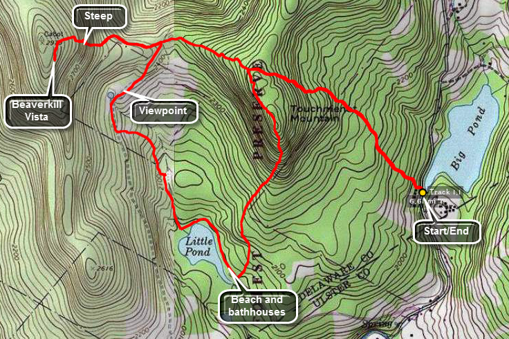 Take the Beaverkill Road from Livingston Manor and drive for about twenty minutes to the intersection
with Barkaboom Rd. Drive up the Barkaboom Rd for less than a mile and park at the forest preserve
parking area. Walk down the access road and up Barkaboom Road for a short distance. The trail begins
on the left and this is where the register is located. After another .75 miles, you reach the
top of Touch-Me-Not Mountain. At this point turn right and stay on the red blazed trail. After .5 miles
this intersects with the yellow blazed Little Pond Trail. Stay on the red trail and get ready to climb!
Cabot Mt is only 2970' high but the ascent is somewhat steep. The Beaverkill Vista gives a beautiful
if somewhat restricted view of the Beaverkill Valley with Little Pond below. Turn around and descend Cabot. Turn right
on the Little Pond Trail which leads to the campgrounds. Along the way there is a nice viewpoint about a quarter mile after the trail junction. The field has an old foundation and a small pond. I always think this would be a great place to have a cabin except for the long hike to get there! As you descend from this viewpoint there may be a few small streams to cross. There is also a beaver meadow on the left of the trail. When you get to the Loop Trail around Little Pond, you may turn left or right. Turning to the right allows you to circle Little Pond and adds .2 miles to the trip. Follow the loop trail to the bathrooms and main buildings. At this point find the blue Campground Trail behind the bathrooms. This trail is steep in places as it climbs back up TouchMeNot Mountain for about 1.15 miles until it meets the
red Touch-Me-Not Trail. Turn right and retrace your steps back to your car at Big Pond. From the bathrooms you may also walk .85 miles out
the Little Pond Campgrounds access road and turn left on Barkaboom Road. After .5 miles you will be back
at the car.
Take the Beaverkill Road from Livingston Manor and drive for about twenty minutes to the intersection
with Barkaboom Rd. Drive up the Barkaboom Rd for less than a mile and park at the forest preserve
parking area. Walk down the access road and up Barkaboom Road for a short distance. The trail begins
on the left and this is where the register is located. After another .75 miles, you reach the
top of Touch-Me-Not Mountain. At this point turn right and stay on the red blazed trail. After .5 miles
this intersects with the yellow blazed Little Pond Trail. Stay on the red trail and get ready to climb!
Cabot Mt is only 2970' high but the ascent is somewhat steep. The Beaverkill Vista gives a beautiful
if somewhat restricted view of the Beaverkill Valley with Little Pond below. Turn around and descend Cabot. Turn right
on the Little Pond Trail which leads to the campgrounds. Along the way there is a nice viewpoint about a quarter mile after the trail junction. The field has an old foundation and a small pond. I always think this would be a great place to have a cabin except for the long hike to get there! As you descend from this viewpoint there may be a few small streams to cross. There is also a beaver meadow on the left of the trail. When you get to the Loop Trail around Little Pond, you may turn left or right. Turning to the right allows you to circle Little Pond and adds .2 miles to the trip. Follow the loop trail to the bathrooms and main buildings. At this point find the blue Campground Trail behind the bathrooms. This trail is steep in places as it climbs back up TouchMeNot Mountain for about 1.15 miles until it meets the
red Touch-Me-Not Trail. Turn right and retrace your steps back to your car at Big Pond. From the bathrooms you may also walk .85 miles out
the Little Pond Campgrounds access road and turn left on Barkaboom Road. After .5 miles you will be back
at the car.
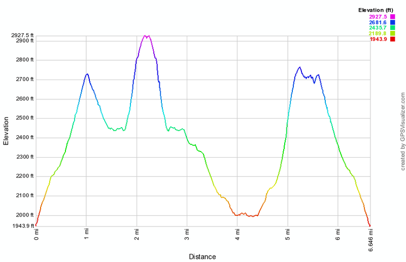 (The image at the left shows the profile of the hike. The highest point is the summit of Cabot Mountain.)