
Ginseng Mt
The Wildcats are two peaks located near Slide Mountain in Ulster County in the town of Denning. There is private land in some areas near the Wildcats so try to stay on state forest. They are two of the wildest peaks on the CHH list. Hikers seldom see another person during their walk and there a few signs of any civilization. The Denning trailhead, one possible starting point, is truly in the "middle of nowhere" and that's just where the hike starts! Another possible starting point is the Slide Mountain trailhead. <
| Quick Look - Ginseng Mt | |||||
|---|---|---|---|---|---|
| Difficulty | Round trip | Total climb | Location | Internet Maps | |
| 6.0 mi. | 1150 ft. | N42.3411 W74.1955 | AllTrails | ||
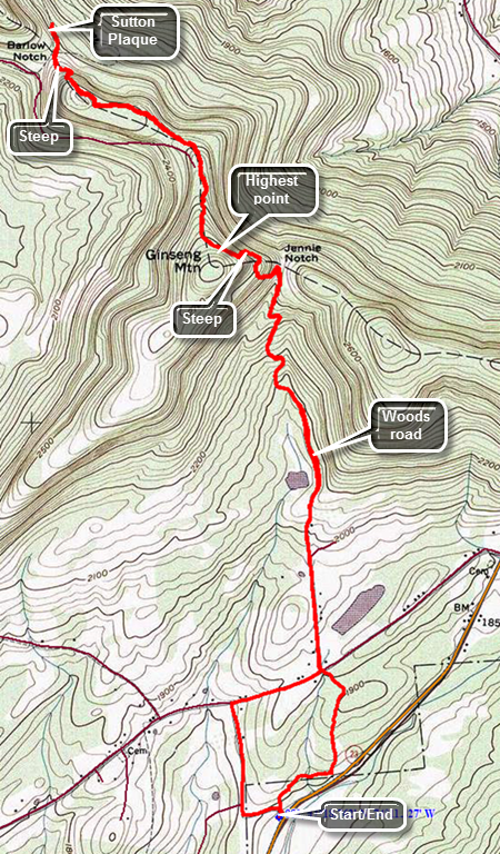
Drive east on Route 23 from the village of Windham. Watch for the Elm Ridge parking area and Cross Road on the left or north side of the road. Park in the parking area and when you are ready walk to Cross Road. Cross the road and find the trail marked with blue plastic discs as well as the aqua blazes of the Long Path. The first .33 miles is pretty flat and actually parallels Route 23. The trail is not always well-maintained and can be overgrown. In addition, the area can be very damp during wet seasons which seems to attract insects. The trail turns north and begins to rise but only slightly. Walking through the evergreens may remind you a little of some of the places over on Windham High Peak. At .75 miles you will come out of the woods and cross Old Road to Jennie Notch Road. The trail follows Jennie Notch Road to where it dead ends. There is a small pond or lake on the right with a mountain behind it which can be quite picturesque. The paved road soon turns to dirt and then ends at about 1.3 miles where there is an open gate. The road actually continues as a grassy lane which is easy to follow even though the blazes are few and far between. Initially the grade of the road is gradual. It is obvious that the road was important and built up with a shale base at some point. You will pass a small pond on the left with some very limited views through the trees. Starting at 1.8 mikes the grade increases until Jennie Notch at about 2.4 miles. Along the way you can see some cliffs on the left which defines part of Ginseng Mountain. There are several switchbacks along the way but at the Notch the trail turns to the left more than 90 degrees. It begins to head up the mountain and soon the grade is 30% or more! This doesn't last very long and between 2.6 and 2.8 miles the trail begins to sidehill along the north shoulder of Ginseng Mountain. The trail levels a little at the top and then starts to descend. Sometime before the descent turn right off the trail and walk a short distance to the top of Ginseng Mountain. Return to the trail and retrace your route to the car.
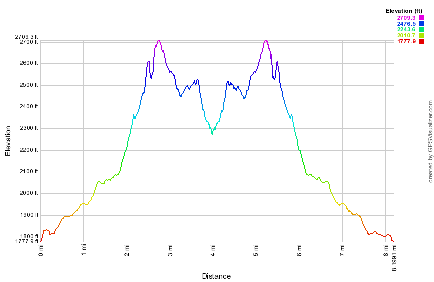 (The image at the left shows the profile of the hike. Remember that all vertical profiles are relative!)
| Quick Look - Wildcats (from Slide trailhead) | |||||
|---|---|---|---|---|---|
| Difficulty | Round trip | Total climb | Location | Internet Maps | |
| 6.8 mi. | 1668 ft. | N41.9877 W74.441 | Google Maps | ||
From Route 55 in Curry between Neversink and Grahamsville, turn left on Route 47, the Frost Valley Road. Drive north and park at the Slide Mountain trailhead just before the Winnisook Club on the right. You may also get to the Slide Mountain trailhead by driving south on Route 47, the Frost Valley Road, and parking in the area just south of the Winnisook Club.
After parking cross the Neversink and stay on the Phoenicia-East Branch trail for about 1.4 miles or so where you can head into the woods in a west-southwest direction. Your bushwhack will take you across the Wildcat Range ridge. Be sure that you look for the highest spots as you go as there are several bumps on near each summit. From Wildcat (the west peak) you can head all the way back, walk out to the Denning trailhead or walk north-northwest to the Biscuit Brook parking area. The last two options require car spots. The last option requires that you cross the Neversink River. The river here can be high at times, the water swift and cold. There are not too many shallow areas to cross and watch out for any private property areas.