
Mount Pleasant
| Quick Look - Mount Pleasant | |||||
|---|---|---|---|---|---|
| Difficulty | Round trip | Total climb | Location | Internet Maps | |
| 9.8 mi. | 2400 ft | N42.03400 W74.30845 | AllTrails | ||

Turn onto Woodland Valley Road from Route 28 west of Phoenicia. After crossing the bridge over the Esopus Creek turn left on High Street even though there may be no sign. Watch for Lane Street on your right after about .5 miles. Turn right on Lane Street and drive to the end and make a right to cross over a small stream. Park in the parking area. For the first 1.4 miles the trail gains over 800 feet passing through some switchbacks heading toward the ridge. From that point the trail ascends to the ridge and heads south gaining elevation along the way. At 2.4 miles the trail passes over the western shoulder of Romer Mountain. Continue passed this point heading south. From here the trail rolls some until it begins the final 560 foot climb up Mount Pleasant. As the trail approaches the highest point it turns due south along the western shoulder of the mountain. To reach the highest point bushwhack slightly to the southeast and climb to the summit of Mount Pleasant. Return along the same route you used to get to the summit and follow the trail back to your car.
This trail was created to move the Long Path from a road walk which was all the way from Tremper Mountain to Woodland Valley Campgrounds to a trail hike. The trail ascends the shoulder of Romer Mountain and then stays on the ridge over Mount Pleasant and Cross Mountain. It joins the trail to Wittenberg just south of the trail junction with the trail to the Terrace Mountain lean-to. It is best hiked with a car spot so that you can hike all the way from one end to the other rather than turning around somewhere in the middle or hiking over 15 miles. The trail ascends the shoulder of Romer Mountain using a series of switchbacks. There aren't many views along the way but the walk is pleasant.
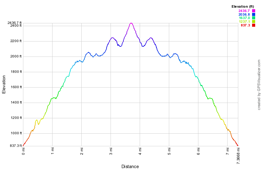
(The image below shows the profile of the out and back hike. Remember that all vertical profiles are relative!)