
Tremper Mountain
| Quick Look - Tremper Mt | ||||
|---|---|---|---|---|
| Difficulty | Round trip | Total climb | Internet Maps | |
| 6.1 mi. | 2100 ft. | AllTrails | ||
 The Tremper Mountain Fire Tower is believed to be the oldest of the reconstructed fire towers in
The Catskills. It was originally constructed elsewhere in 1917 and then moved to its present location.
The trail is mostly along an old road to the summit. It has many switchbacks which make the route
Not as steep as it might be but also add length to the distance. Views of the surrounding mountains
are easily has had from the fire tower.
The Tremper Mountain Fire Tower is believed to be the oldest of the reconstructed fire towers in
The Catskills. It was originally constructed elsewhere in 1917 and then moved to its present location.
The trail is mostly along an old road to the summit. It has many switchbacks which make the route
Not as steep as it might be but also add length to the distance. Views of the surrounding mountains
are easily has had from the fire tower.
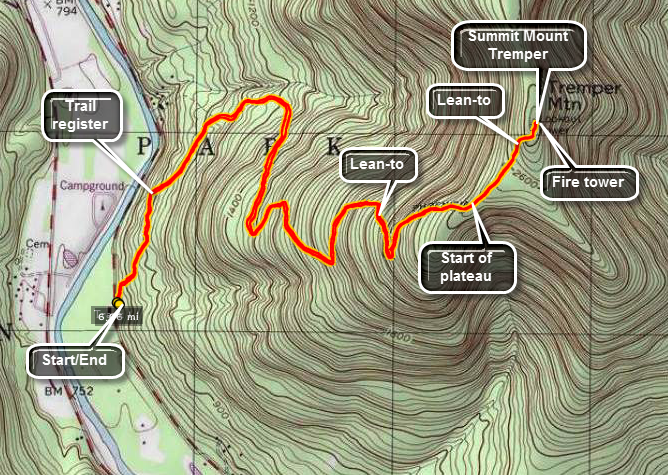
From Rt. 28 turn at the sign that indicates the village of Phoenicia. Continue straight through town until the sign for Rt. 40. Continue of Rt. 40 for about 3/4 of a mile. Pass the first parking area on your right. Park at the next parking area on the left. This area has a sign for the Tremper Mountain Fire Tower. Walk over three bridges and up a hill on the stone steps. Don't be surprised at the lack of a trail register at this point. The register is a little over a quarter mile on the trail. From here follow the well-marked red Phoenicia trail to the tower. The trail is an old road to the tower. It has many switchbacks which makes the incline quiet easy but lengthens the hike. It is possible to cut some of the switchbacks or bushwhack the entire way. BE CAREFUL! There are reports of timber rattlesnakes in this area!
The trail eventually reaches a plateau and after a short hike and a short climb you will be at the fire tower. This tower is surrounded by trees until you get near the top. The views are nice but not as interesting as the ones from Overlook, Balsam or Hunter on a nice day. Retrace your trail and you will be back at your car.
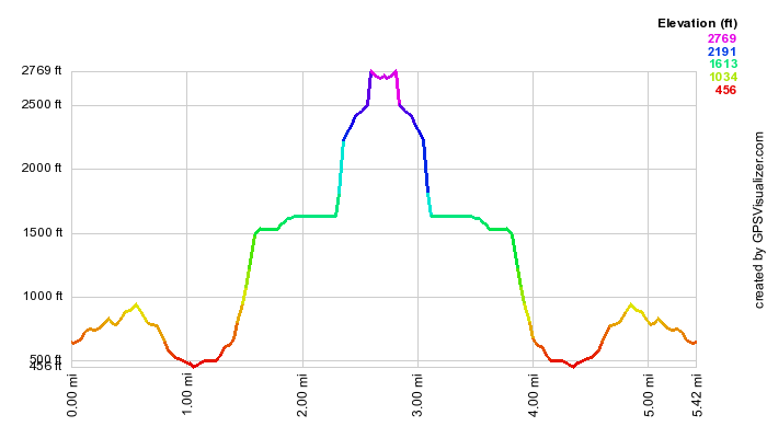 (The image at the left shows the profile of the hike. Remember that all vertical profiles are relative!)