
| Pick a Catskill 35 Peak: |
Graham Mountain
| Trailhead Coordinates | |
|---|---|
| Name | Coordinates |
| Beaverkill Road (end) | N42.0239 W74.5998 |
| Millbrook Road | N42.0704 W74.5738 |
| Alder Lake | N42.0499 W74.6827 |
| Quick Look - Graham and Balsam Lake from Beaverkill | ||||
|---|---|---|---|---|
| Difficulty | Round trip | Total climb | Location | Internet Maps |
| 8.5 mi. | 2165 ft. | N42.0392 W74.5500 | AllTrails | |
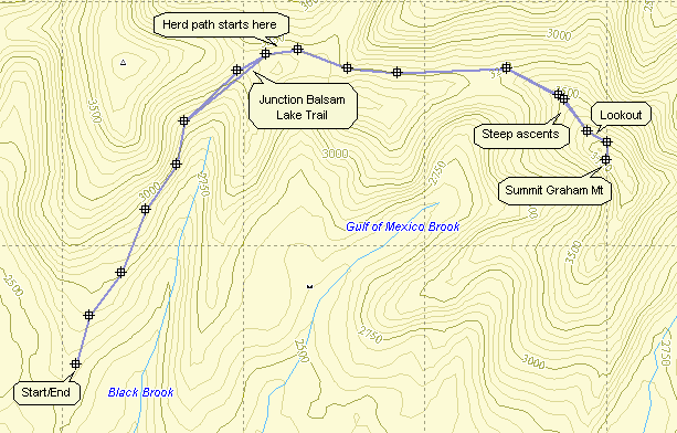
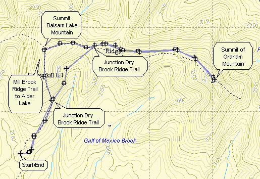 From the intersection of Old Route 17 and DeBruce Road in Livingston Manor, drive 1.3 miles north to Beaverkill Road. Turn right on Beaverkill Road and drive 20 miles to the end of the Beaverkill Road passing through Lew Beach and Turnwood. Park at the trailhead at the end of the Beaverkill Road. The public road dead ends at this spot and a private road on the left continues to the Balsam Lake Lodge. Find the blue-blazed Dry Brook Ridge Trail and hike .9 miles to the first trail junction. Continue straight ahead on the blue-blazed trail to 1.9 miles to a second junction with the Balsam Lake Mountain Trail. Continue straight ahead for .2 miles watching for a path on the right side of the trail. Turn right and follow this path. The path starts a rather gentle ascent with some places descending slightly. At 3.2 miles the path begins a steeper ascent climbing 625 ft. in .8 miles to the summit of Graham Mountain. At the summit there are the ruins of a post-WW II radio repeater station. Descend from the summit following the same route you used on the way up. Turn left at the main trail and hike .2 miles to the junction with the red Balsam Lake Mountain Trail. Turn right and begin the ascent to the summit. The trail gains 415 ft. in .7 miles with several steep sections alternating with flatter areas. The reward for the climb is the fire tower at the summit of the mountain. There is no view from the ground but the views from the tower take in most of the 3500 foot peaks. To return to the parking area continue on the red trail as it exits the summit to the south. The first part of this trail is a gentle descent which becomes steeper as it starts down a set of stone steps near a spring. The steps are often damp and slippery. Along the way the Millbrook Ridge Trail to Alder lake branches to the right at 7 miles. A spur trail to the right just below the spring leads to a lean-to. The trail from the summit to the junction with the blue Dry Brook Ridge Trail is only .8 miles but the loss in elevation is 830 feet. Parts of the trail average a 28% grade. Turn right on the red trail at the bottom of the descent and hike .9 miles back to the car.
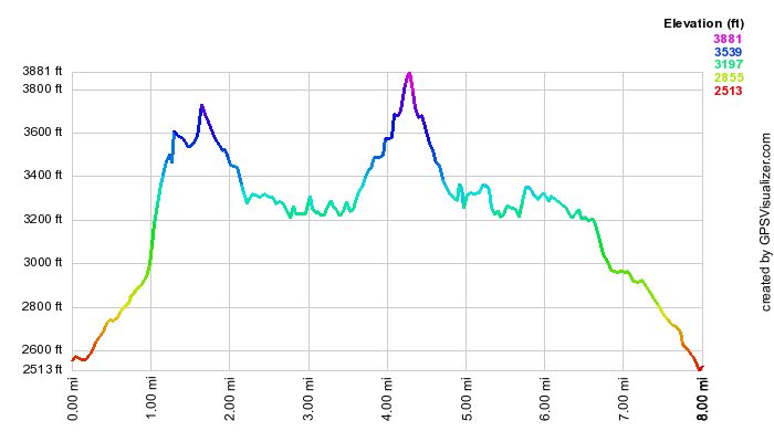
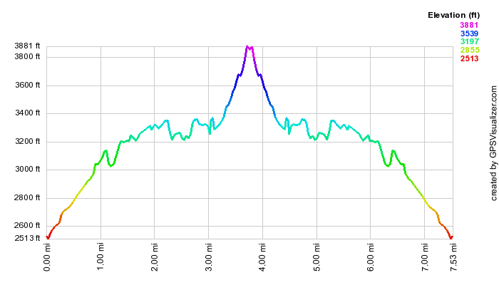
(The image at the left is the vertical profile for the round trip hike. Graham has several points where you think you are at the top but aren't!)
| Quick Look - Graham and Balsam Lake from Millbrook | ||||
|---|---|---|---|---|
| Difficulty | Round trip | Total climb | Location | Internet Maps |
| 10.4 mi. | 2670 ft. | N42 02.73 W74 53.70 | AllTrails | |
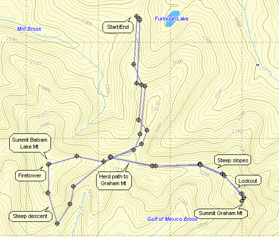
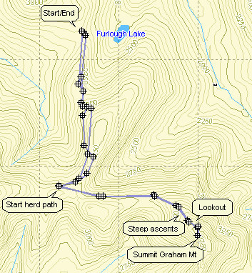
From the bridge in Margaretville drive east on Route 28 for 1.1 miles to Dry Brook Road in Arkville. Turn right and drive 6 miles to Millbrook Road. Turn right and drive about 2.2 miles to the parking area on the right. From the intersection of Rt 7 and Rt 30 east of Downsville drive 11.7 mile east on Route 30 along the Pepacton Reservoir to the Dunraven Bridge. Turn right on BWS 8 and drive 1.9 miles. Turn left on BWS 9 and drive 4.6 miles to Millbrook Road. Turn right and drive 9.8 miles to the parking area on the left. Cross Millbrook Road and begin your hike on the blue Dry Brook Ridge Trail. Much of the trail is on an old woods road which is still passable by four wheel drive vehicle. Hike 1.9 miles to the herd path to Graham on the left. Turn left and follow this path. The path starts a rather gentle ascent with some places descending slightly. At 3.0 miles the path begins a steeper ascent climbing 625 ft. in .8 miles to the summit of Graham Mountain. At the summit there are the ruins of a post-WW II radio repeater station. Descend from the summit following the same route you used on the way up. Turn left at the main trail and hike .2 miles to the junction with the red Balsam Lake Mountain Trail. Turn right and begin the ascent to the summit. The trail gains 415 ft. in .7 miles with several steep sections alternating with flatter areas. The reward for the climb is the fire tower at the summit of the mountain. There is no view from the ground but the views from the tower take in most of the 3500 foot peaks. To return to the parking area continue on the red trail as it exits the summit to the south. The first part of this trail is a gentle descent which becomes steeper as it starts down a set of stone steps near a spring. The steps are often damp and slippery. Along the way the Millbrook Ridge Trail to Alder lake branches to the right at 6.7 miles. A spur trail to the right just below the spring leads to a lean-to. The trail from the summit to the junction with the blue Dry Brook Ridge Trail is only .8 miles but the loss in elevation is 830 feet. Parts of the trail average a 28% grade. At the junction with the red Dry Brook Ridge Trail turn left and hike 3.1 miles back to the parking area.
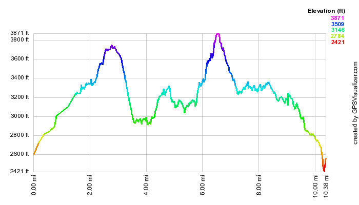
(The image above is the vertical profile for the hike.)
| Quick Look - Graham from Beaverkill | ||||
|---|---|---|---|---|
| Difficulty | Round trip | Total climb | Location | Internet Maps |
| 7.9 mi. | 1900 ft. | N42 02.73 W74 53.70 | AllTrails | |
From the intersection of Old Route 17 and DeBruce Road in Livingston Manor, drive 1.3 miles north to Beaverkill Road. Turn right on Beaverkill Road and drive 20 miles to the end of the Beaverkill Road passing through Lew Beach and Turnwood. Park at the trailhead at the end of the Beaverkill Road. The public road dead ends at this spot and a private road on the left continues to the Balsam Lake Lodge. Find the blue-blazed Dry Brook Ridge Trail and hike .9 miles to the first trail junction. Continue straight ahead on the blue-blazed trail to 1.9 miles to a second junction with the Balsam Lake Mountain Trail. Continue straight ahead for .2 miles watching for a path on the right side of the trail. Turn right and follow this path. The path starts a rather gentle ascent with some places descending slightly. At 3.2 miles the path begins a steeper ascent climbing 625 ft. in .8 miles to the summit of Graham Mountain. At the summit there are the ruins of a post-WW II radio repeater station. Descend from the summit following the same route you used on the way up. Turn left at the main trail and hike .2 miles to the junction with the red Balsam Lake Mountain Trail. Continue straight ahead on the blue Dry Brook Ridge trail. Hike 1.8 miles downhill back to the car.
(The image above is the vertical profile for the hike.)
| Quick Look - Graham from Millbrook | ||||
|---|---|---|---|---|
| Difficulty | Round trip | Total climb | Location | Internet Maps |
| 7.8 mi. | 1850 ft. | N42 02.73 W74 53.70 | AllTrails | |
From the bridge in Margaretville drive east on Route 28 for 1.1 miles to Dry Brook Road in Arkville. Turn right and drive 6 miles to Millbrook Road. Turn right and drive about 2.2 miles to the parking area on the right. From the intersection of Rt 7 and Rt 30 east of Downsville drive 11.7 mile east on Route 30 along the Pepacton Reservoir to the Dunraven Bridge. Turn right on BWS 8 and drive 1.9 miles. Turn left on BWS 9 and drive 4.6 miles to Millbrook Road. Turn right and drive 9.8 miles to the parking area on the left. Cross Millbrook Road and begin your hike on the blue Dry Brook Ridge Trail. Much of the trail is on an old woods road which is still passable by four wheel drive vehicle. Hike 1.9 miles to the herd path to Graham on the left. Turn left and follow this path. The path starts a rather gentle ascent with some places descending slightly. At 3.0 miles the path begins a steeper ascent climbing 625 ft. in .8 miles to the summit of Graham Mountain. At the summit there are the ruins of a post-WW II radio repeater station. Descend from the summit following the same route you used on the way up. Turn right at the main trail and hike 1.9 miles back to the parking area.
(The image above is the vertical profile for the hike.)