| Pick a Catskill 35 Peak: |
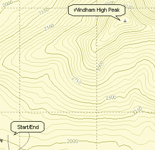
Windham High Peak
Windham is the northernmost 3500. Some approaches are easy and the view from the top can be as far as Albany on a clear day.
| Trailhead Coordinates | |
|---|---|
| Name | Coordinates |
| Batavia Kill | N42.2886 W74.1143 |
| Peck Road | N 42.2967 W74.1694 |
| Route 23 | N 42.31259 W 74.19040 |
| Quick Look - Windham High Peak from Peck Road | ||||
|---|---|---|---|---|
| Difficulty | Round trip | Total climb | Location | Internet Maps |
| 6.5 mi. | 1494 ft. | N42.3147 W74.1439 | AllTrails | |
From Rt. 23C take Maplecrest Road north to Maplecrest and then turn right onto Big Hollow Rd. After a short distance turn left onto Peck Rd. and park in the parking area near the end. Find the yellow-blazed Elm Ridge trail and continue on this trail for .85 miles where it crosses the blue-blazed Escarpment Trail. Take a right here and stay on the trail for 2.4 miles to the summit of Windham High Peak (3524 ft.) This trail winds through some boggy areas where old log foot "bridges" are slowly rotting away. After taking in the view on a clear day, turn around and retrace the same route to the parking area.
Windham can also be approached from the east by parking further along Big Hollow Rd. Access is along
a part of the Black Dome Range trail which intersects the Escarpment Trail that leads to the peak. The
path described above is shorter and certainly not very challenging.
| Quick Look - Windham High Peak from Big Hollow | ||||
|---|---|---|---|---|
| Difficulty | Round trip | Total climb | Location | Internet Maps |
| 6.4 mi. | 2207 ft. | N42 18.88 W74 08.62 | AllTrails | |
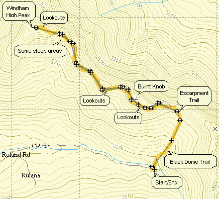
From Rt. 23C take Maplecrest Road north to Maplecrest and then turn right onto Big Hollow Rd. Go to the "end" of Big Hollow Road and park in the parking area on the right. You may also use the snow plow turn around on the left when there is no snow. On the left side of the road find the trail head for the red-blazed Black Dome Trail. The first water crossing across Batavia Kill is on a bridge so there is no problem. Right after the bridge and trail register you must cross a small tributary which can be all but impossible during high water. If you cannot cross here, you may be able to bushwhack along the left side of the stream to an easier crossing. I have bushwhacked all the way up to the Escarpment Trail without too many problems.
After about a mile the Black Dome Trail ends at a T with the blue-blazed Escarpment Trail. Turn left toward Burnt Knob and Windham High Peak. The climb up Burnt Knob is short but can be tricky. In the winter the narrow trail is hard to negotiate with snow shoes. In the drier seasons the loose dirt in some areas makes falling very easy. After about .25 miles there is a side trail to the left which offers a beautiful view of the Blackhead Range to the south. Back on the main trail you will begin to descend from Burnt Knob in only .1 miles. There is a view of Windham just as you begin to descend. The view is much better when there are no leaves on the trees. After about 1.5 miles of most flat walking the climb up Windham begins. There are several spots along the way that offer views; some better than others. One spot in particular is about halfway between Burnt Knob and Windham. Walk of the trail to the right and a rock ledge offers wonderful views to the north and east.
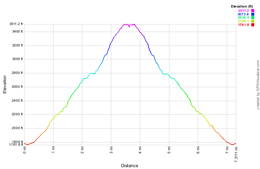
The climb up Windham gets steeper at times but a few switchbacks help out. The distance is less than a mile and Windham is only 3524 ft. in elevation. As you near the top there are two nice lookouts on the right. Continue on to a big pine tree near the top that marks the highest spot on the peak. Retrace your steps to the lookouts and enjoy the view. To get back just reverse your course and return the way you came.
| Quick Look - Windham High Peak from Route 23 | ||||
|---|---|---|---|---|
| Difficulty | Round trip | Total climb | Location | Internet Maps |
| 7.3 mi. | 1860 ft. | N 42.31259 W 74.19040 | AllTrails | |
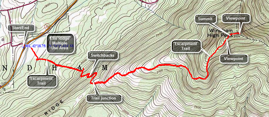
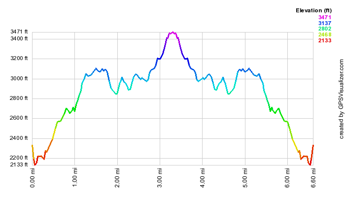
Drive east on Route 23 from the village of Windham. Watch for the Elm Ridge parking area and Cross Road on the left or north side of the road. Park in the parking area and when you are ready walk across Route 23 to the blue blazed Escarpment Trail on the other side of the road just opposite Cross Road. The first part of the trail crosses over a wetland on abridge and some walkways. You will come to a kiosk and a set of trails that branch from the main trail to Windham. These trails are multiuse trails popular with local residents for walking and also used by mountain bikers. Stay on the main trail which after .3 miles begins to get steeper on its ascent up the mountain. The ascent never gets very steep but it is constant as the trail passes through mostly hardwood forests to a trail junction. A few switchbacks along the way moderate what might be a steeper ascent. At about 1.5 miles the Elm Ridge Trail intersects the main Escarpment Trail. There is a lean-to on the right at this junction. Turn left on the Escarpment Trail and stay on the trail for 2.4 miles to the summit of Windham High Peak (3524 ft.) This trail winds through some boggy areas where old log foot "bridges" are slowly rotting away. The woods turn from hardwoods to pines and then back to hardwoods again. The area under the lines can be "spooky" and there are plenty of roots to avoid. Then final climb up Windham gets a little steeper but the views that reward you are worth the climb. Once you reach the summit plateau continue to hike across the top until the trail begins to drop again. Along the way you will be treated to a view on the right to the south which reveals the entire Blackhead Range. A little after this viewpoint is the summit of Windham. DO NOT turn around here as the next viewpoint is only a few hundred feet away. This viewpoint on the left of the trail takes in the area to the north of the Catskills. On a clear day Albany is visible as are the mountains from Huntersfield to Mount Pisgah. After taking in the view, turn around and retrace the same route to the parking area.
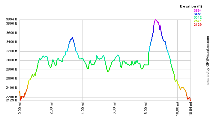
| Quick Look - Windham High Peak and Blackhead from Big Hollow | ||||
|---|---|---|---|---|
| Difficulty | Round trip | Total climb | Internet Maps | |
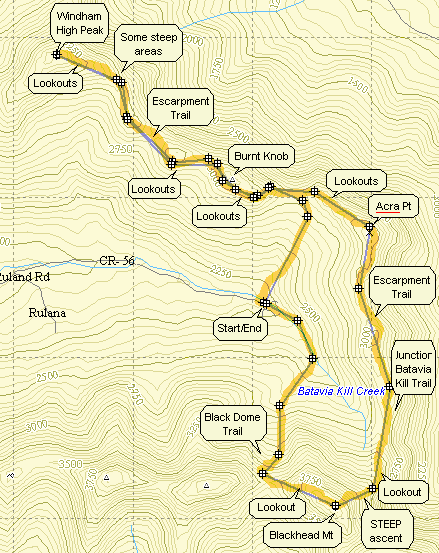
From Rt. 23C take Maplecrest Road north to Maplecrest and then turn right onto Big Hollow Rd. Go to the "end" of Big Hollow Road and park in the parking area on the right. You may also use the snow plow turn around on the left when there is no snow. On the left side of the road find the trail head for the red-blazed Black Dome Trail. The first water crossing across Batavia Kill is on a bridge so there is no problem. Right after the bridge and trail register you must cross a small tributary which can be all but impossible during high water. If you cannot cross here, you may be able to bushwhack along the left side of the stream to an easier crossing. After about a mile the Black Dome Trail ends at a T with the blue-blazed Escarpment Trail. Turn left toward Burnt Knob and Windham High Peak. The climb up Burnt Knob is short but can be tricky. In the winter the narrow trail is hard to negotiate with snow shoes. In the drier seasons the loose dirt in some areas makes falling very easy. After about .25 miles there is a side trail to the left which offers a beautiful view of the Blackhead Range to the south. Back on the main trail you will begin to descend from Burnt Knob in only .1 miles. There is a view of Windham just as you begin to descend. The view is much better when there are no leaves on the trees. After about 1.5 miles of most flat walking the climb up Windham begins. There are several spots along the way that offer views; some better than others. One spot in particular is about halfway between Burnt Knob and Windham. Walk off the trail to the right and a rock ledge offers wonderful views to the north and east. The climb up Windham gets steeper at times but a few switchbacks help out. The distance is less than a mile and Windham is only 3524 ft. in elevation. As you near the top there are two nice lookouts on the right. Continue on to a big pine tree near the top that marks the highest spot on the peak. Retrace your steps to the lookouts and enjoy the view. To get back to the junction with the Black Dome Trail just reverse your course and return the way you came. At the trail junction continue straight ahead on the Escarpment Trail as it ascends Acra Point. There are some nice views of the valley from lookouts on Acra Point. At 7.9 miles into the hike the Batavia Kill Trail departs to the right. Stay on the Escarpment Trail by continuing straight ahead and get ready for the most challenging climb of the hike up the east side of Blackhead. This part of the Escarpment Trail begins to ascend almost immediately and although it does level out after the first ascent it then becomes VERY STEEP. It rises around 1300 feet in less than one mile. At 8.6 miles you will be at the open rock that marks the summit of Blackhead. Signs here indicate that the Escarpment Trail goes to the left. Turn right on the Blackhead Trail which takes you across the summit plateau and then down to Lockwood Gap. Along the way there are some lookouts which have nice views of Black Dome. At the trail junction in Lockwood Gap turn right to take the Black Dome Trail back to the parking area. The walk back to the car is about 1.6 miles but it is all downhill dropping over 1200 feet!